Travel: From Hwy 12, travel south for 30.4 miles on the Hole In The Rock Road. Turn left/east and go 1.0 mile to a large parking area at the trailhead. 2WD vehicles with good clearance should suffice although the final mile is off-camber in places.
Distance and Elevation Gain: 17.8 miles, 500 feet of climbing
Time: 7:00 to 9:00
Difficulty: Trail and wash walking (take water sandals or get your boots wet); navigation easy; no exposure
Maps: Big Hollow Wash, King Mesa, UT 7.5 Quads; Trails Illustrated: Canyons of the Escalante No. 710
Date Hiked: October 24, 2014
Historical Note: Jacob Hamblin, born April 2, 1819, was a Mormon pioneer who helped settle the American Southwest. He was highly respected for pursuing peace with Native Americans, ensuring the safety of Mormon migrants. He extensively explored the Grand Canyon and helped John Wesley Powell plan his second trip on the river.
Quote: If you know wilderness in the way that you know love, you would be unwilling to let it go.
Terry Tempest Williams
Sun shines through the arch to light the back wall of the alcove that houses it.

Route: There are four well-documented routes to the arch. Located within the Grand Staircase-Escalante National Monument, this is a straightforward roundtrip hike from the Red Well TH down Coyote Gulch. For those continuing on, overnight permits are available free from the Escalante Interagency Visitor Center in Escalante.

This image looks west to Fifty Mile Bench and Straight Cliffs from the trail register at TH 4,525'.

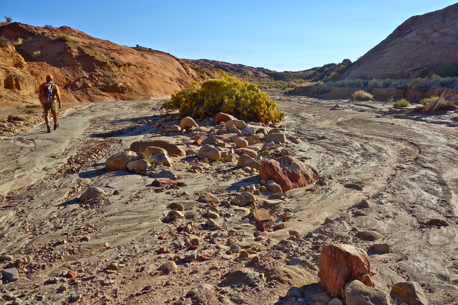
Walk east on an abandoned road and cross into the Glen Canyon National Recreation Area at 0.3 mile.

The road thins to a single track which splits to later rejoin. Stairstep steeply down a talcum dirt ramp into Big Hollow Wash. A cairn marks this important route into and out of the wash. In a few steps, Coyote Gulch joins downcanyon-right (DCR).

Coyote is broad, flat, and firm-bottomed with low walls. Old, widely branching cottonwoods co-exist with rabbitbrush.
Water begins flowing just before (ironically) the Dry Fork of Coyote Gulch joins downcanyon-left (DCL) at 2.0 miles. Now, passage is brushy with braided trails. Running water is shallow and small crossing logs are sufficient to ford without getting your boots soaked. At 2.9 miles come to a waterfall. Bypass DCR. The trail splits after climbing 150 feet; both re-enter the wash.

At 3.5 miles, canyon walls noticeably heighten.

There are multiple crossings.
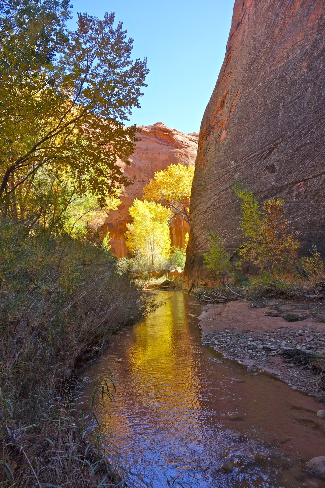
At 4.5 miles, pass through a gate, fastening the chain. Two tributaries add significant water at 4.9 and 5.8 miles DCL. Sheer walls overhang the river and shade prevails in late October. Many beautiful alcoves reside throughout the canyon.

At 6.7 miles, the river makes a sharp bend to the right and a side canyon joins DCL. At 6.9 miles, mighty Hurricane Wash comes in DCR. Many people choose to access Jacob Hamblin Arch from the Hurricane TH because it is a couple of miles shorter roundtrip. I heard it called, "The Death March" years ago but I don't know if that is a valid descriptor. There is excellent camping at the confluence. This curvy area, with so much going on, is a little confusing; just follow the flow downstream. It is another 1.6 miles to the arch.

The final stretch has the highest walls, over 400 feet tall. They are pleasantly decorated with black varnish, stripes, and lichen. Along the base are seeps and hanging gardens. The river is tightly coiled like a serpent. Nature clearly loves the circle; one bend forms a 270 degree arc with 100 feet of overhang. The canyon is reminiscent of the Paria River.
After Hurricane swooshed in, water sandals were a relief. At 7.7 miles there is a side canyon, DCL. Almost there! At 8.5 miles, the river makes a sharp turn to the right. The massive arch is in an alcove located on the outside of the bend. The geometry is unusual. The river has created goosenecks. Therefore, the walls are peninsular with an alcove in the apex. At Jacob Hamblin, the arch is formed in the roof of the alcove, creating a tunnel-like look.

You can climb up the rubble pile under the arch from this side, but it is impossible to descend on the other, down-river side, shown. (THW, photo)

Turn around and trek home just as you came. I'm not sure about the mileage. My GPS read 8.5 miles one way to the arch but two devices had a total of 17.8 miles. It is a long way home. While many people eschew out-and-backs in favor of a loop, I feel otherwise. The experience is such a sensory overload, it begs to be reversed.

Camping: I prefer Sooner Rocks, south of Dance Hall Rock. Camp on slickrock and friction climb on the sandstone. There are humongous tanks covering this formation. Below is a stitched image of the mother of all tanks, at least 150 feet deep. This is one of three giant sandstone weathering pits in south-central Utah. (THW, photo)

An important note from author Steve Allen about protecting endangered National Monuments in Southern Utah.
I'm a great great great grandson of Jacob Hamblin who Jacob Hamblin Arch was named after. Learn more about Jacob Hamblin on the Jacob Hamblin family website at www.jacobhamblin.org.
ReplyDeleteJake, Thanks for leaving the link. What a beautiful website honoring your patriarch. Debra
Delete