Travel: Long Canyon Road (Kane County Road 6020/BLM 750), is off US 89 between Kanab, Utah and Page, Arizona. In a 4WD with good clearance, turn south 0.6 mile west of the Paria Contact Station (and 0.2 mile west of the Paria River) at mile marker 21.4, the location of Paria Outpost. Zero out your trip meter. In 2013 the dirt road was washed out and impassible. In 2016, it was smooth and excellent. Open and close the gate after the second cattle guard and cross Long Canyon at 1.1 miles. The canyon soon slots up, the road on its left. Pass the third cattle guard at 2.7 miles and cross the wash for the last time at 3.3 miles. The track climbs the center of a narrow, precipitous spine (Do not attempt when wet!) to gain West Clark Bench at 4.2 miles. Avoid all roads branching off to the right. At 5.1 miles, stay straight on BLM 750, avoiding a turn to the right and then the left. The road is subject to sandy patches and there is one short stony cluster that requires good clearance. Park at 7.8 miles where there is a green gate, a solitary juniper, and a Middle Route Trailhead sign and register box. No facilities.
Distance and Elevation Gain: 7.4 miles RT to the arch with 700 feet of total elevation gain; 9.0 miles for the loop with 1,200 feet of climbing
Time: 4:00 to 6:00 depending on route
Difficulty: Trail to Cobra Arch, off-trail along Buckskin Rim, no cairns on Middle Route in 2016; navigation challenging for the loop; no exposure except for the optional downclimb into Buckskin Gulch on the Middle Route; carry all the water you will need
Maps: West Clark Bench, Utah-Ariz 7.5 Quad (a must for the loop hike); Trails Illustrated No. 859, Paria Canyon, Kanab
Date Hiked: April 21, 2016
Poem:
No my soul is not asleep,
It is awake, wide awake.
It neither sleeps nor dreams, but watches,
its clear eyes open,
far-off things, and listens
at the shores of the great silence. Antonio Machado
Cobra Arch looks like a venomous snake, striations down the length of its body, eyes keeping watch. Or, view it literally as a statuesque span of Navajo Sandstone accentuating a Utah blue skylight, its beauty deeply enthralling.
(THW, photo)

Route: The Cobra Arch trail bears southeasterly from the Middle Route Trailhead. It follows the rim of The Dive to a rare break in the Carmel Formation, drops 200 feet, and curves under Point 5,119'. Most hikers will return from the arch as they came. For the navigation savvy, turn the hike into a loop by going southwest to the Buckskin Gulch rim and walking beside the finger canyon for two miles to intersect the Middle Route (which may be hard to detect) just before the plunge into Buckskin. Return north on the route back to the trailhead.

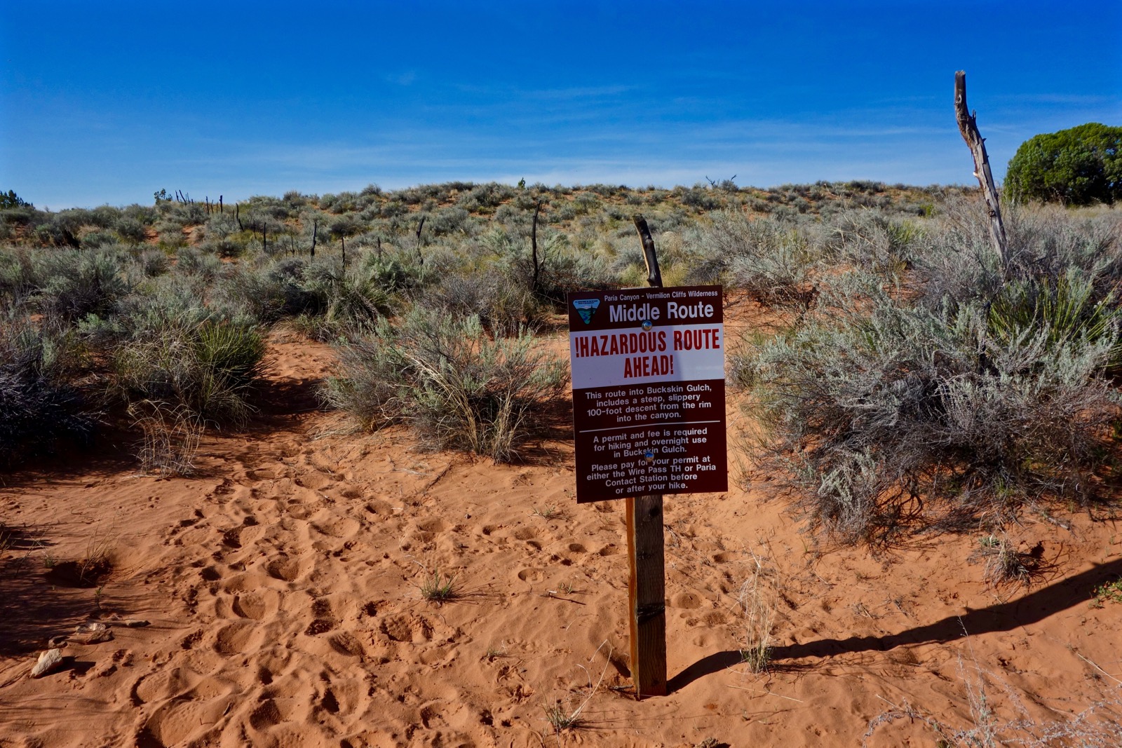
The Cobra Arch and Middle Route Trailhead is just west of USGS survey marker 4,979'. If you plan to use the Middle Route as access into Buckskin Gulch, take the hazard warning seriously. Bring a rope to lower backpacks and carry a permit for an overnight stay. Sign the register and walk south on the east side of a fence, entering the Paria Canyon-Vermilion Cliffs Wilderness (BLM) as you do so.
The track is sandy at first but soon transitions to firm dirt that pierces a sage flat accented with euphedra. An expansive view opens to the south, shown. The Buckskin trench is decipherable, behind it, Steamboat Rock and the cones of Coyote Buttes.

Reach the rim of The Dive and turn east with the trail at 0.2 mile. At 0.3 mile there is a small cairn that presumably marks the junction with the Middle Route. In 2016, this route was not cairned, neither is it on any of my maps lending a surprising sense of obscurity for one of the four permitted routes into the Paria Canyon complex.
The route to Cobra Arch stays on top of The Dive while seeking a weakness in the persistent Carmel Formation cliff band. The Dive is the wall that separates West Clark Bench from Buckskin Gulch. The Carmel is the surface layer and beneath is red Page Sandstone and then creamy white Navajo Sandstone. In this area, the Navajo is stained red by the Page.
The eastward trail passes by beautifully sculpted juniper skeletons. Thriving are snakeweed, prickly pear, and buffaloberry. The flat and fast walking surface could not be easier. It rates 100 points on the pleasure scale. The path turns south along with the rim at 0.7 mile. Now you can clearly see the Buckskin rift and the unmistakable solitary butte in White Pocket.
Reach gently rounded Pt. 5,047' at 1.2 miles. Divert a few steps to the rocky perch for a better view of Pt. 5,119' and our route at its base. The zigzagging Dive goes east and then southeast. Notice a cluster of stacked standing rocks below the trail, shown.

After passing above these peculiar effigies, at 2.3 miles a cairn, image-center, marks the location of the Class 2 drop off West Clark Bench.

Follow the cairns southwest down a rock runner. In April, the leaves of shrub oak are shiny green and cliff rose smells like fancy soap with a hint of cinnamon. (THW, photo)

At 2.6 miles, cairns direct onto a minor ridge but you may stay in the wash since the trail shortly rejoins and crosses it. The trail ascends a sand dune and then a 150 foot sand mountain. You may walk around the latter in the drainage if you'd rather, so long as you divert over to the arch. The dunes are covered in Indian ricegrass, and in the spring, blooming orange globe mallow, primrose, deer vetch, purple spiderwort and primitive-looking yucca blossoms. From their height see the spectacular fins and cross-bedding on the gorgeous walls of The Dive below Pt. 5,119', a geological wonder. (THW, photo)

The second sand dune leads into a chaotic and photogenic cluster of small red domes with turtleback weathering, fluted channels, and a short slot. This charming geology is typical of The Dive runout zones in Navajo Sandstone. Take some time in this lumpy bowl complex. (THW, photo)

The arch is located on the south side of the red stone pocket at 3.7 miles, elevation 4,680 feet. This primal structure with characteristic serpent markings all down its back and two perfect eyes in its hooded head, rises 30 feet up from the earth and spans 35 feet. The underbelly is about eight feet wide. (THW, photo)

Unlike so many unattainable arches, it is a simple scramble to stand on the arced back. (THW, photo)

The serpent stands guard over the distant spell-binding confluence of Buckskin Gulch and the Paria River.
(THW, photo)

Return as you came. If you are doing the loop, walk southwest across a sandy flat and at 4.4 miles, reach the rim of Buckskin Gulch. The canyon floor is enveloped in darkness and the force of the chasm is chilling. Follow the rim as it makes a sharp bend northwest at 4.6 miles. The perimeter world is an astonishing place in its own right with domes extruding fragile fins and claret cup cacti blooming crimson. Progress is steady with no major obstacles on the bench of the rugged rim. The other side looks less accommodating. (THW, photo)

At 5.4 miles, cross the first of two shallow washes in quick succession. Just before the third wash at 6.0 miles, it is possible to see a sliver of canyon floor. Watch for Moqui marbles and a chert flintknapping site. (THW, photo)

We walked by a boulder hefted by lace. (THW, photo)

Shortly before meeting up with the Middle Route, passage is blocked by cliffs and assorted structures. Accumulate some elevation while finding a way through this area. Our diversion is shown on the map above.

At 6.7 miles, 4,540 feet, we passed a crude, block wall. I am not sure if it was erected by cowboys or Ancestral Puebloans. Just east of the Middle Route is a smooth wall with a deep patina and small petroglyphs depicting bighorn sheep and anthropomorphs.

Upon reaching a shallow drainage, we saw footprints in the sand, confirming we were on the Middle Route. Strangely, there were no cairns anywhere. We followed the dry wash to the brink of the chasm.

At 7.1 miles, we reached a very steep friction pitch and got half way down before our shoes lost their stick and we feared for our traction. Next time we will start from the interior of Buckskin Gulch. From our vantage point, it was impossible to see what challenges follow the initial pitch.

Middle Route is clearly an ancient path. High on the east wall overlooking the slim canyon and humans passing through the ages, is a petroglyph panel with sheep and an anthropomorph, image-center.

There were no cairns to mark the return. It worked nicely to ascend the pretty wash indicated on the map above. Find a mix of deep sand, bedrock, and easy step-ups. By 8.0 miles we were clearly off-route because there were no footprints. I'm speculating the route left the wash and went north as indicated by the blue dots on the map (a guess). Meanwhile, we pleasantly followed the streambed northeast and connected with the trail just 0.6 mile east of the trailhead. It was a perfectly good route, if not the official one.
An important note from author Steve Allen about protecting endangered National Monuments in Southern Utah.
No comments:
Post a Comment