Travel From Durango Via Cinnamon Pass: In a 4WD, high-clearance vehicle, from Durango drive 47 miles to Silverton. Turn northeast and proceed up Greene Street, the main drag, to the north end of town. Zero-out your trip meter as you make a soft right onto San Juan CR 2. The dirt road is good at first but degenerates to a slow, rocky surface. In 11.5 miles, 0.5 mile before reaching the abandoned mining town of Animas Forks, there is a brown sign directing you to go right for Cinnamon Pass. You are now on the Alpine Loop. At 11.8 miles, stay right. Drive over bedrock outcrops with uneven ledges. At 12.1 miles there is a sign where the roads to Engineer Pass and Cinnamon Pass split. Make a sharp switchback to the right. This initial shelf section has some off-camber bedrock. The track is steep, narrow, and rocky. Reach the pass, 12,640 feet, at 14.3 miles. Negotiate four, super tight, ledgy switchbacks. At 16.1 miles, continue straight at the spur road to American Basin. Parking for the Cooper Creek Trailhead at 19.4 miles is on the right. There is a good camp here with access to the Lake Fork of the Gunnison River. We kept company with coyote, deer, porcupine, and moose. Allow 2:15 to 2:45 from Durango.
Travel Via Lake City: Drive about two miles south on Colorado 149 and turn right on County Road 30, the Alpine Loop, toward Lake San Cristobal and Cinnamon Pass. Zero-out your trip meter. Stay right near 11.8 miles. After 12.5 miles the road becomes rougher, and between 13 and 14.5 miles it is a shelf road that hugs the south flank of Sunshine Peak. The Cooper Creek Trailhead is just shy of 17 miles with a small parking lot on the left. When it is dry, good-clearance 2WD vehicles should make it to the trailhead. Allow an hour from Lake City.
Distance and Elevation Gain, East Peaks: 11.5 miles; 3,750 feet of climbing
West Peaks: 8.8 miles; 3,800 feet of vertical
East and West Peaks Combination Loop: 13.5 miles; 5,950 feet of gain
Time: Allow 7:00 to 8:30 for East and West loops separately
Difficulty: Trail, off-trail; navigation moderate; East loop is Class 2 with mild exposure; West loop is Class 2+ with intermittent serious exposure
Map: Redcloud Peak, Colorado 7.5 Quad
Dates Hiked: July 13, 2016, East; July 14, 2016, West
Quote: Fear less, hope more. Eat less, chew more. Whine less, breathe more. Talk less, say more. Hate less, love more. And all good things are yours. Gudy Gaskill's favorite Swedish aphorism
Coincidentally, we were standing on Gudy Peak the day Gudy Gaskill died. Old man of the mountain gave the Mother of the Colorado Trail an enthusiastic send-off. (THW, photo)

From Gudy Peak look down on the eastward climbing ridge and Cooper Lake. Image-center is Point 13,484'. Every Mountain is to its right and Cooper Creek Peak, far right. (THW, photo)

Route: Both loops are best done counterclockwise. For the east black-line loop, walk up the Cooper Creek Trail until it crosses the creek at 11,560 feet. Curve off-trail around Pt. 13,405'. Climb northeast to the ridge between Every Mountain and Cooper Creek Peak. Do an out-and-back to Cooper Creek Peak. Climb Every Mountain and Pt. 13,484'. Descend west and then southwest intersecting the trail to Cooper Lake and return to the trailhead on the Cooper Creek Trail. For the west blue-line loop, start once again on the Cooper Creek Trail. Use it to ascend around the base of Gudy Peak's east ridge. Just before Cooper Lake, climb steeply south and gain the east ridge. From Gudy Peak, travel southwest over C.T. Peak and out to the end of the Cooper Creek west ridge. Drop to the west and exit via the Rock Creek drainage. The red lines represent steep route alternatives that friends used successfully.

Cooper Creek Peaks East, Day One
From the trailhead at elevation 10,620 feet, the trail goes north and then curves around to the east on relatively flat terrain. This image shows the camp directly across the road from the trailhead. Rock Creek drainage is image-left and Pt. 13,041' is image-right. (THW, photo)

Sign in at the registration box at 0.4 mile where the trail kicks up. The forest thickens; aspen are lively but conifers are sadly dying from beetle infestation. Cross Cooper Creek at 1.3 miles, elevation 11,160 feet. This would be a boots-off proposition much earlier in the season. Pass a fallen-down, hand hewn log cabin in the woods at 1.6 miles. The path goes directly up the massive drainage with 13'ers on both sides. Before you see Cooper Creek Peak at the upper end of the east ridge, pass under Pt. 13,041', Pt. 13,405', and Pt. 13,471'. C.T. Peak on the west side is visible for a few moments and then Gudy Peak dominates for a good long while, image-center. We saw a ptarmigan protecting her chicks and a golden eagle probing for prey.

At 2.55 miles, 11,560 feet, the lake trail crosses the creek. Leave the trail here, staying on the east side, the black-line route. The topo shows an old trail curving east under Pt. 13,405' but it has essentially been obliterated by scaling red talus. We saw a cairn or two and trail fragments but they are superfluous.

Make a wide sweeping bend into the east fork of Cooper Creek basin. Out from under the talus, walking is pleasant on tundra. Cross to the north side of the stream at about 3.6 miles, 11,900 feet. Cooper Creek Peak is finally visible just left of image-center. Head to the north side of a deep orange trench. We were unable to locate the prospect noted on the topo and apparently walked right over it. In the vicinity of the trench, start climbing northeast to the ridge. Our direct and excellent route weaved through minor outcrops of orange talus and then returned to tundra. We saw signs of abundant elk as we made the moderately steep climb.

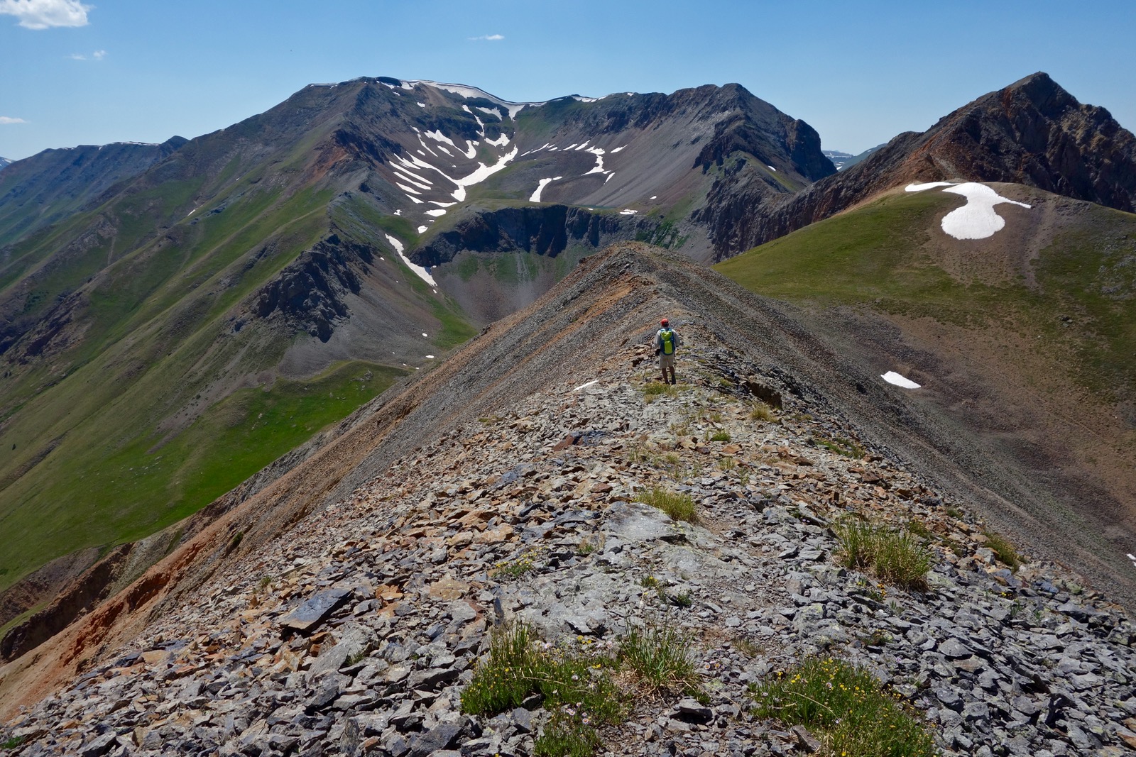
Gain the ridge at 4.7 miles, about 13,380 feet. Cooper Creek Peak, Pt. 13,688', is a hulking, somewhat unattractive mountain half a mile and 300 feet of vertical away to the south. A faint use trail skirts the ridge proper. Why compromise when the scree/talus mix lends itself to staying on the edge of this world. In return, see the ridge running east with two centennial peaks and spikes that put respect in anyone's heart. In this image, Redcloud Peak is just coming into view, image-center.

Crest Cooper Creek Peak at 5.35 miles. Close by are Redcloud Peak, Sunshine Peak, and Sundog. Afar are San Luis Peak and Rio Grande Pyramid. There are better views to come of peaks in the west and north. Incidentally, it looks like it would be a cinch to climb this mountain from the Silver Creek Trail. Only two parties signed the peak register so far in 2016. This image swings from Every Mountain on the right to Gudy Peak cradling Cooper Lake.

Finish the roundtrip at 6.0 miles. Every Mountain, Pt. 13,691', has a complicated southeast climbing ridge. Make use of the social trail offered slope side, southwest of the ridge. The platform is adequate as it swings around to the tiny ridge saddle at the base of the summit block. We caught sight of a bighorn sheep above us on the ridge proper. Summit Every Mountain at 6.8 miles.

You will see half the known world from Every Mountain. Look down into Cooper Lake cradled beneath the continuation of this ridge. The next goal is Point 13,484'. Between here and there is a fairly narrow ridge of broken talus. Several of the wildcat trail go-rounds were too exposed and we chose to stay on the spine. There are good features on the paprika knob. The grey ridge is capped with white rock impregnated with crystal sparkles. Reach the prominence at 7.3 miles.

Here's a look back at the ridge between Every Mountain and Pt. 13,484'. Don't rush this short segment.

The scalloped rib turns west. The descent ridge to the 12,880 foot saddle with Pt. 13,131' is pleasant and generous. My friends who did this entire circuit in one day carried on to Gudy Peak by way of Pt. 13,131' which rises northeast over Cooper Lake. They are technical climbers comfortable with exposed garbage rock. The alternative for reaching Gudy Peak is from the lake outlet. Reach the saddle shown below at 7.8 miles.
The map indicates another prospect in the saddle which we did not see. An old trail once served the prospect. It is all business and goes southwest down the pitch. In 0.1 mile the trail splits. The right option appears to be a slightly better choice for plunging down this gnarly, steep little slope. Cross Cooper Lake outlet at about 8.2 miles, 12,220 feet, and intersect the Cooper Creek Trail. The under-utilized track has been largely swallowed by tundra. Whether you are returning to the trailhead or going to Gudy Peak, just keep walking parallel to the creek until you stumble on the trail. Gudy Peak and C.T. Peak have rock on the loose with significant exposure so tackle these on the same day only if you still have an abundance of mindful energy and the weather is stellar. For those going to the trailhead, close the loop at the 11,560 foot creek crossing at 8.95 miles. The image below shows the lake outlet and Cooper Creek Peak from the 12,200 foot crossing.

Cooper Creek Peaks West, Day Two
From the Cooper Creek Trailhead at 10,620 feet, walk up the trail and this time, cross the creek at 2.55 miles, 11,560 feet. The trail does a rising traverse to the north. The path is two-boots wide and plants are growing in the track so it's not a surprise that it is barely visible or altogether gone as it runs parallel to the lake outlet. As it curves around the end of Gudy Peak's east ridge, shown image-left, the path will become more obvious. Just stay on the south side of the creek, follow the cairns, and make for the upper basin. On the map above, you will notice a red-line route. Some friends successfully bailed from the ridge during a storm on this ultra-steep option. I recommend you take the gentler and more beautiful blue-line route.

This image depicts the basin below the Cooper Lake headwall where the outlet stream briefly runs soft and flat. Water spills over the escarpment in a cascade on the right. (THW, photo)

The trail climbs very steeply up the south/left side of the headwall. The traction sucks, the material crappy and loose. Trekking poles are helpful for this challenge. The trail then goes across a gully through a weakness and makes for the lake. Once past the gully there is a minor tundra platform. Look here for the lowest angle, green-slope approach to the east ridge and begin climbing south. We let a snow field divert us onto a 250 foot climb to the ridge prematurely. This was a mistake. The extraordinarily steep pitch had horrible footing on ball bearings over explosive bubble rock with tumbling exposure. We hit the ridge at 12,820 feet; you should reach it 100 feet higher.

Once on the ridge, pictured, go straight up the first knob. The rock is surprisingly tenuous. An entire section of the nose peeled off in my hold. (THW, photo)

The ridge is rather thin with moderate exposure. Occasionally the taper falls away steeply and the exposure is serious. You will need to bypass left in a few places. Don't trust the rock. Once beyond the couloir gash the terrain eases. This image looks down on Cooper Lake from the ridge.

Scale up the center of the summit block on better rock, a Class 2+ scramble. For me, it was the most enjoyable part of the climb. (THW, photo)

Right near the crest was a sky pilot bouquet and sculptural cornice.

Reach the alluring, long summit ridge of Gudy Peak, Pt. 13,566' at 4.3 miles. Elevation gain to this point is 3,080 feet. The summit register is on the highpoint just north of the ridge juncture. Only two parties had been on the peak so far in 2016. The view highlights Mount Sneffles and the three Uncompahgre brothers: Wetterhorn Peak, Matterhorn Peak, and Uncompahgre Peak which gets grand prize for relief, image-right. Coxcomb Peak and Redcliff are west/left of Wetterhorn.

Watch for ptarmigan while descending the roomy, talus-coated southwest ridge. This image depicts the thin backbone leading to C.T. Peak.

Hit the saddle at 5.0 miles, 12,860 feet. The first section of the spine is a knife but the footing is good. Stay just left of the right-hand drop. There is quite a bit of exposure but you can always find a good route. Just be mindful and deliberate.

The last 150 feet up the summit block looks better the closer you get to it. The rock is good, the experience a pleasure.

Doing the loop counterclockwise enables climbers to ascend the steep and exposed segments and descend on the more rounded ridges. This image looks back on the upcoming ridge. Today's west-side peaks are not gimmes. Crest C.T. Peak, Point 13,312' at 5.3 miles. The view is the most astonishing of the day. Get a good look at one of my favorite hikes to Wildhorse Peak and Dragon's Back.

Flowing from C.T. Peak to the southwest is the wide, almost flat, gorgeous divide paralleling Cooper Creek and Hensen Creek, the corridor that carries the Alpine Loop up and over Engineer Pass. Having hiked the Whitecross Mountain, Handies Peak, Point 13,795' circuit only days prior, I am captivated by the full spectrum view of all three mountains from this vantage point, image-left. (THW, photo)

Reach the end of the suspended part of the ridge at six miles, 13,260 feet. There is no trivial exit via Rock Creek. Going in the opposite direction, friends were able to locate a trail starting from the Colorado Trail Foundation cabin that took them to timberline. They then struck for the ridge on a route that was like going up a whirlpool of falling rock. However, this may be a decent downhill option. Their route is depicted with a red line on my map. In 2016, the cabin was for sale and access may soon be nixed.
Meanwhile, our plan was to climb Points 12,896', 13,540B, 13,477', 13,427', 13,250' and exit via Cleveland Gulch. It was a gentle drop off the ridge due west and up to Pt. 12,896' (topping it at 6.8 miles) to get a closer look at Pt. 13,540B, pictured. Achieving the prominence looked every bit as troublesome as an internet trip report suggested. We hatched a new plan for another day, to walk out to Pt. 13,540B from Cinnamon Pass. A friend reports filigree quartz rock along the way to Pt. 13,427'. (THW, photo)

Even from this lowly 12,000 footer the view north is indisputably stunning. (THW, photo)

Our exit route was inglorious but functioned fairly well until quite close to the Cinnamon Pass Road. Return southwest to the draw, the upper reaches of Rock Creek at 12,600 feet. Work your way down the talus field, avoiding the faces of rock glaciers. While in this region we could hear the incomparable music of water flowing unseen under rock.

Once on tundra, work the southwest side of Rock Creek staying well above it. The route functioned nicely until we got into aspen thickets and minor cliffs while bottoming out. Notice how the blue-line route practically kisses the red-line route at 11,000 feet. Somewhere in that vicinity cross the creek and see if you can stumble onto the trail originating at the cabin. There is no-doubt a private property work-around. Eventually, you'll get dumped back out onto the road about a quarter mile west of the trailhead. In this image, my climbing partner is relishing tundra on the west side of Rock Creek at its emergence zone.

Flowers blooming in the Cooper Creek region in July, 2016: harebell, heart leaf arnica, Jacob's ladder, rayless senecio, osha, myrtle blueberry, bluebell, American bistort, lousewort, monkshood, orange sneezeweed, elephant head, aspen daisy, alpine avens, veronica, native thistle, delphinium, burnt orange agoseris, pygmy bitterroot, minuartia, old man of the mountain, sibbaldia, moss campion, alp lily, alpine violet, snow buttercup, sky pilot, smelowskia (purple!), Fremont senecio, wall flower, king's crown, columbine, pink prairie smoke, corn husk lily, Whipple's penstemon, mouse ear chickweed, strawberry, Richardson's geranium, pussy toes, cinquefoil, caraway, candytuft, yarrow, death camus, Coulter's erigeron, buckwheat, little sunflower, fairy candelabra, tall forget-me-not, mat penstemon, alpine clover, mountain gold, alumroot, whiplash daisy, meadow rue, alpine phlox, and paintbrush: Indian, sulfur, hybridized, and rosy.
No comments:
Post a Comment