Travel: The only navigation challenge is locating Blixt Road which is one of several tracks branching north from Ophir Pass Road. For those traveling from the east link to Yellow Mountain South for a detailed description of Ophir Pass Road. It is 4.1 miles from US Route 550 to the top of the pass. Unmarked Blixt Road is shortly west of Chapman Gulch, 2.0 miles west of Ophir Pass. There is no parking at this juncture so continue downhill 0.2 mile and park on the north side of the road in a pullout at Iron Spring, across from Swamp Canyon Trail, elevation 10,180. This is approximately one mile east of Ophir.
Distance and Elevation Gain: 5.8 miles roundtrip; 3,250 feet of climbing from the parking pullout.
Time: 3:30 to 4:30
Difficulty: Historic wagon road; navigation easy once you locate Blixt Road; no exposure
Maps: Ophir; Telluride, Colorado 7.5 USGS Quads
Date Hiked: July 23, 2017
History: The Ophir/Iron Spring Mining District peaked in the late 1800's when over a thousand people lived in Ophir. Ore was transported to smelters in Silverton over Ophir Pass. Blixt Road linked the Ophir Mining District with Bridal Veil Basin. Brothers Oscar, Gator, and Harry Blixt were sons of a Leadville miner; the three worked the mines outside of Telluride. Blixt Road was built by Oscar. Both Oscar’s Pass and the mountain due west of the pass, Oscar’s Peak, is named for him.
Quote: Clouds move on and the day opens to distance. Whole symphonies live between here and a distant whatever-we-look-at. Richard Hugo
Looking south from Oscar's Peak, the town of Ophir is beside the banks of the Howard Fork of the San Miguel River. The luminous block of peaks rimming the cavernous space include South Lookout Peak, U S Grant Peak, Fuller Peak, Vermilion Peak, Pilot Knob, San Miguel Peak, and Yellow Mountain. (THW, photo)

Route: From the juncture of Ophir Pass Road and Blixt Road, climb north up the south-facing wall of the east-west running ridge dominated by Silver Mountain. From Oscar's Pass climb 300 feet and 0.2 mile west to Oscar's Peak.

From the parking pullout at Iron Spring walk steeply east up Ophir Pass Road. Midsummer, lanky delphinium, cow parsnip, and osha cover the shady floor of the old aspen forest. Continue past the first side road on the left at 0.15 mile. It swings northwest off-route. Unsigned Blixt Road is in another 50 yards, 0.2 mile from the parking area at elevation 10,330 feet. Branch left at an acute angle onto Blixt Road, shown.

The two-track heads north up an established avalanche path, a noteworthy characteristic. Even down in the canyon views are immediate. Hovering above Swamp Canyon is South Lookout Peak, Swamp Pass, U S Grant, and V3.

At 0.35 mile (0.15 mile from Ophir Pass Road), elevation 10,460 feet, the road briefly peters out. Notice a green gate lying on the ground. Turn east/right onto a single track.

After a couple hundred feet of climbing the trail transitions back to an obvious abandoned road that remains a two-track to the pass. Cross a stream in the center of another slide path at 0.7 mile. Climbing consistently, Ophir drops away. Yellow Mountain is image-left. Lizard Head, the Wilson group and Sunshine Mountain are on the right.

Leave the aspen forest behind at 11,180 feet. The track swings parallel to Chapman Gulch while keeping the drainage to the east. (THW, photo)

At 1.35 miles, pass by an old and faded Road Closed sign. "Here to Telluride is a mixture of private and public land. The mine owners haven't fenced you out. Respect their rights and property. Tread lightly." (THW, photo)

Break out of the conifers at 11,700 feet and soon the broad pass is revealed. We inadvertently scared up an elk herd so we took a break to allow them to move on. In this image the elk are on the track where Blixt Road switches to the east away from a secondary mine road at 12,240 feet.
Below, hikers pause beneath the sun west of Point 13,614'. (THW, photo)

Blixt Road was cleaved into a brick-red, ultra steep talus slope. Oscar laboriously built berms using native rock to stabilize the road. Were it not for his masterful engineering the wagon road would have sloughed off and disappeared some time ago.

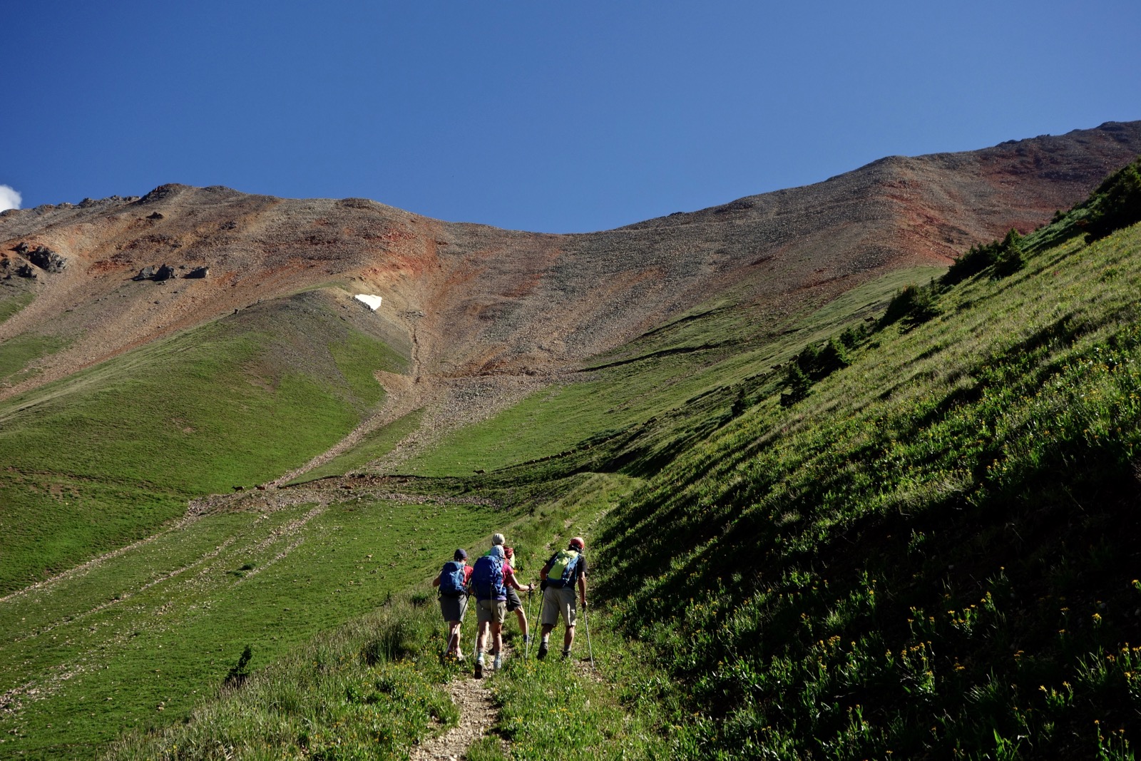
Below, hikers are about to top Oscar's Pass, elevation 13,130 feet, at 2.7 miles. Ophir Pass Road is image-center.
(Rich Butler, photo)

Blixt Road goes up and over the pass and heads down into Bridal Veil Basin. For thru hikers going to Telluride there are three options: Wasatch Connection to Gold Hill; East Fork to Bear Creek; and Bridal Veil Basin to Bridal Veil Creek and the Black Bear Pass switchbacks (see Nader's SummitPost).
From Oscar's Pass look north into Bridal Veil Basin. Three Needles are image-left and Lewis Lake is below "Columbine Pass," 13,058'. Although there are more direct routes to Columbine Lake from the east, there are social trail fragments into the basin and over Columbine Pass to the lake.

From Oscar's Pass it is a quick and simple 0.2 mile northwest to the peak on a relatively broad ridge of broken rock. It is a shallower incline than most of the road.

Strong hikers will crest the roomy flat summit in under two hours. 

The humble peak doesn't call attention to itself but the panorama is one of the best in Colorado. The mountain resides east of midway on a ridge that spans the Ophir Needles, Silver Mountain, Oscar's Peak, Point 13,614', and Lookout Peak.
It looks like you can continue west on the ridge. However, there is a vertical wall east of San Joaquin Ridge Summit that will likely prohibit travel on to Silver Mountain.

North, Wasatch Mountain and La Junta Peak form the divide between the Bear Creek and Bridal Veil Creek watersheds. Uncompahgre Peak, the highest mountain in the San Juans, has landmark status far to the northeast. (THW, photo)

We intended to climb Point 13,614' east of Oscar's Pass, image-left, but weather chased us off the ridge. Lookout Peak is to its right. The bright blue dot is Crystal Lake, a short and highly recommended walk from Ophir Pass.

Trotting down Blixt Road there is one flat switchback, shown below. Overall, this is one of those descents that feels steeper (and perhaps more punishing) than the climb. It is hard to imagine maneuvering heavily loaded burros on the steep path. Perhaps equally impressive, the road now hosts the swift and ultralight runners of the Hardrock 100.
(THW, photo)

A very satisfying, lovely hike...the reward is the absolutely stunning 360 degree view from the top!
ReplyDeleteI am the Great Niece of Oscar Blixt. Oscar took my father and me up Bridal Veil Falls, past the Blixt brothers mine and down the shale road he constructed into Ophir in 1967. It was a thrill. Knew the three brothers. Littleton CO
ReplyDeleteCarolyn, You are living Colorado's history! Thrill, for sure, and privilege as well. Thank you so much for you personal comment on this site. Debra
DeleteDebra,
ReplyDeleteFirst thank you for your blog. It's truly amazing and I love your flora and fauna descriptions!
Second, do you know if you can link Oscar's to San Joaquin Ridge summit...looks possible on top. Just curious if you've done that variant?
I'm happy you are enjoying the blog. Check out the post for San Joaquin Ridge Summit. The opening photo was shot from San Joaquin looking east to Oscar's. So close! At the time we wanted to make the traverse but discarded the idea. "A vertical wall prohibits further travel east, making it impossible to traverse to Oscar's Peak."
Delete