Travel: In Tucson, drive east on Tanque Verde Road and turn left on the Catalina Highway. Drive 5.3 miles and park in a large pullout on the right at the Coronado National Forest sign. This is just before the highway hooks a hard right.
Distance and Elevation Gain: 4.6 miles; 1,460 feet of climbing
Time: 3:00 to 4:00
Difficulty: Off-trail, trail; navigation moderate; Class 3 wall with mild exposure; gneiss is slick--wear sticky shoes
Maps: Agua Caliente Hill, AZ 7.5 USGS Quad or Apogee Mapping; Pusch Ridge Wilderness, Coronado National Forest, USDA Forest Service, 1:24,000
Latest Date Hiked: December 6, 2017
Haiku: Boulder pools await,
A memory of water,
Chuparosa blooms. Thomas Holt Ward
Water flows down multiple courses at the first waterfall series in Soldier Canyon. (THW, photo)

Route: From the Catalina Highway walk north off-trail up Soldier Canyon. Upon reaching a massive chockstone, bypass south and climb a slope to intersect the Soldier Canyon Trail. Descend south on the trail to the highway. Walk down the road to the start. The blue line represents the Soldier Canyon Trail northbound to Gordon Hirabayashi Recreation Area. This alternative exit requires a shuttle. See the end of this post for a map of the upper canyon. Note for Rock Climbers: The Hairpin Turn Area is a moderate sport and mixed climbing venue. Link to Mountain Project for a description of the many routes.
From the parking pullout at 3,020 feet, walk up the highway a few paces and cross the road, entering the canyon.

The canyon walls and continuous boulder field is comprised of Santa Catalina Gneiss. Sotol, prickly pear, desert hackberry, bursage, occasional cottonwood and Arizona oak enliven the canyonscape. Saguaro cling to craggy slopes.

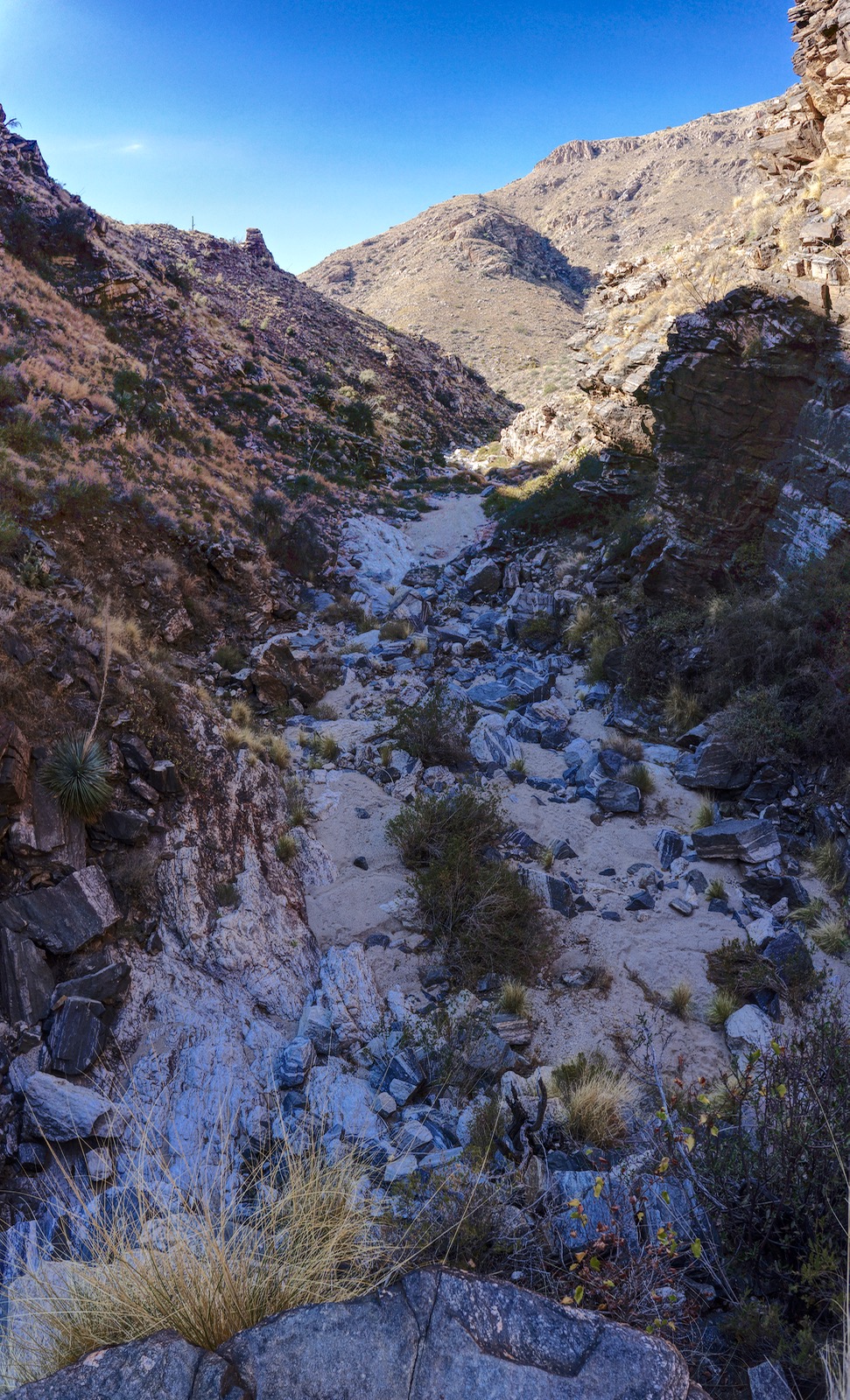
The Catalina Mountains have a great many choked canyons. This ephemeral watershed is relatively small so brush is sparse. You see the essence of this landscape elsewhere but rarely are two full miles of obstruction-free clamoring strung together. The improbability of the route, the proximity to town--it's heaven on earth.

At 0.4 mile, the main fork makes a sharp turn to the northeast/right. My hiking partner has explored the north tributary searching for an egress. He climbed the steep pitch on loose boulders but got repelled at the keyhole in the upper cliffs, shown. The rugged route is not recommended. (THW, photo snapped at the hairpin)

Arrive at the two-tiered waterfall featured in the opening photo. The easiest bypass of the lower fall is upcanyon-left on stair steps. This is an exhilarating class 2 climb.

This image looks down from the upper fall. Tanks are dry after six rainless weeks in autumn, 2017. When flush, water splits into multiple cascades. (THW, photo)

Half a mile into the hike pass beneath a popular climber's wall on the right.

Unlike many restricted chasms which offer but one slim passage, here freestyle bouldering is multiple choice and every option looks appealing. Sometimes the easiest way is through.

In one mile, a steep and brushy side canyon joins upcanyon-right. The main canyon jogs left. This signals the beginning of gigantic boulder jumbles and an increase in difficulty. Either climb the 20 foot slick, slanted boulder, shown, or bypass on the left. Next, skirt left around a 50 foot-tall monument barring the passageway.

Three tall blocks lean right. Go into the opening, as if into a cave. An attempt to bypass on the left got us tangled up in hackberry. Once in the inviting hole, climb up a razor rock and exit right.

Emerge at the base of another climbing wall and scramble into the clear.

Enter a peaceful paradise upon a sandy beach at the base of water carved gneiss sheets. In the Santa Catalina Mountains forerange, intrusive igneous rock was subjected to high temperatures and pressure within the Earth's crust creating gneiss metamorphic rock. Minerals were separated into bands and while the rock was in a molten state, it was subject to ptygmatic folding creating the white crystalline wavy patterns seen below. (THW, photo looking downstream)

In early December, desert honeysuckle, chuparosa, was broadcasting a profusion of red-orange trumpets. (THW, photo)

The gradient and challenge ease for a time. (THW, photo looking back)

At 1.3 miles a side canyon enters upcanyon-left. The main canyon curves to the right and takes you along with it. Pass another tributary entering on the left at 1.6 miles. This final canyon segment is exceptionally beautiful, climaxing in a natural theater with a wide sandy floor and seating on a gently rising stone slope. Approach a 100 foot-tall wall, shown. (THW, photo)

The Class 3 wall has some exposure. If you wish to turn around here, descending the canyon is no more difficult than arising. As seen in the image below, there is a waterfall on the right. The canyon extends further on the left into a narrow crack. Enter the cleft and climb the wall on your right. (THW, photo)

Part way up, move right on a ledge back around toward the main fall. Or, scout around for a route that suits you better. This image was shot looking downcanyon from midway up the wall. (THW, photo)
Here's a look at the final scramble.

Walk on bedrock encased within stone walls. The channel narrows as it bends south. A show-stopper chockstone marks the definitive end of our passage within the canyon.

Ascend the sidewalk on the left.

It soon becomes obvious that there is no way to penetrate deeper into the canyon. Enclosed on three sides, this is a wild, crazy and dramatic end to the lower canyon. The rock radiates power. (THW, photo)

Looking out from within. (THW, photo)

To leave the canyon, walk back down the sidewalk and continue a few more paces. Watch for a viable escape route downcanyon-left. While climbing the steep, brushy hillside, be cautious for there is some exposure. A cliff band near the top of the 200 foot climb will push you to the right. Emerge onto a wide and flat rock platform in Soldier Basin at 2.0 miles, 4,400 feet. The Soldier Canyon Trail is on the shelf just feet away. (If you are going on to Hirabayashi, you may back up and exit the canyon on the west, less exposure, more brush.)

The return route goes south on the Soldier Canyon Trail. However, it is well worth the 0.4 mile spur to peer into the abyss above the chockstone even though you can't catch a glimpse of the monster.

The Soldier Canyon Trail was constructed over 100 years ago and is one of the original footpaths on the Santa Catalina front range. In the 1930's, Trico Electric Cooperative strung up a powerline to the Federal Prison Camp at what is now Gordon Hirabayashi Campground. Prisoners labored to build the Mt. Lemmon Highway. During World War II, some of the prisoners were conscientious objectors. In 1942, Dr. Gordon Hirabayashi challenged the constitutionality of incarcerating Japanese Americans following the attack on Pearl Harbor in 1941. He was convicted and sentenced to serve at the prison camp now named in his honor. Walking down the trail you will see severed power poles, left where they lay.
The trail parallels Soldier Canyon for a time before turning southeast into a small drainage. Vegetation is classic Sonoran: ocotillo, sotol, prickly pear, barrel cactus, mesquite, whitethorn acacia, and cholla: pencil, teddybear, and staghorn. Saguaro grow more numerous as you descend. The track becomes increasingly rubble-filled as it dives toward the roadway.

Pass out of the Pusch Ridge Wilderness at 3.6 miles and hit the pavement at 3.8. It is a fast, pleasant walk down the Catalina Highway on a good shoulder. As you near the hairpin there is a nice view into Soldier Canyon.

Upper Soldier Canyon
Essence: Turn Soldier Canyon into a thru-hike to Hirabayashi. Or, simply do the upper loop as a short, peaceful stroll coupled with playful scrambling. Pure pleasure!
Travel: Drive up the Catalina Highway and turn left at the sign for Gordon Hirabayashi Recreation Area, Mile Marker 7.3. The trailhead is 0.3 mile from the highway.
Distance and Elevation Gain: For the loop, 3.0 miles; 650 feet
Total Time: 1:45 - 2:30
Difficulty: Trail; Class 2+ scrambling with mild exposure
Route: From Hirabayashi Trailhead, walk southwest on the Arizona Trail (AZT) and transfer to the Soldier Canyon Trail. Upon reaching the creek, leave the trail and walk up the canyon.

The trailhead, elevation 4,840 feet, is on the west side of the parking lot. Begin on the AZT (Molino Basin Trail) and transfer to the signed Soldier Canyon Trail in a quarter mile. An elder oak tree minds the junction. The footpath rises gently and crosses into the Pusch Ridge Wilderness. Take a spur trail to the high point of the hike at 4,880 feet, 0.5 mile. From the overview, look through the canyon’s wedge to Tucson and Baboquivari Peak. The Soldier Canyon gorge is in the chasm below. Notice the climbers on the wall, image-center.

The trail makes a steady descent to the canyon floor and crosses the creek at 1.3 miles, elevation 4,380 feet. Leave the trail here and turn upstream. While there are some brushy places, most of the hindering vegetation was blown out in the 2021 monsoons. The experience is positively sublime rising through the lovely grassland basin on gneiss stairsteps. A side canyon joins upcanyon-left at 1.7 miles.

Confront the first of four obstacles at 2.1 miles. The 20-foot pouroff and fall initiates the scrambling series in the upper canyon. Climb up the rock, just left of the falls. It is exposed for the first 20 feet with good traction. Then work the ledges to finish the bypass.

Next, is a low waterfall plugged by a chockstone. Bypass upcanyon-left. (THW, photo)

The gorge constricts but progress continues.

Water spills over stone and swishes into a pool. The pond ripples. Light dances on a vertical sheer wall. The bypass is upcanyon-right (off-image). It might look intimidating but it is welcoming. Don’t over-climb. Descend back onto the canyon floor beside a sculpted dead tree. (THW, photo)

We wrestled with the fourth and final obstacle at 2.6 miles but were thwarted. The exit from the gorge is upcanyon-left. Walk up the ramp (image-left) and then scale blocks for 80 feet. Once free of the gorge walk on a social trail back to the venerable oak tree and close the loop.

No comments:
Post a Comment