Thursday, March 29, 2018

Quartz Peak, 4,052', and Butterfly Mountain, 4,119': Sierra Estrella

Essence: Sierra Estrella (Star Mountains) is southwest of Phoenix and highly visible from the metropolis. The range runs northwest to southeast with Quartz Peak on the ridgecrest just south of the mid-point. Perhaps the entire range was named for the small prominence that blazes star bright in twilight. Yet, in its presence white stone is cool to the touch, reflective as the moon. The Quartz Peak Trail is the only pathway in the range and it is extraordinary. Contrary to warnings on the web, it is easy to follow. The final 0.6 mile is Class 2+. Quartz is a subsidiary of Butterfly Mountain. Only those with considerable experience hiking off-trail in the desert should tackle the one-mile traverse to the East Wing. The ridge is brushy and the scramble up the summit block is exposed. The West Wing must be protected. The Sierra Estrella Wilderness (managed by the BLM) is bounded by the Gila River Indian Community on the north and east; BLM, state, and private lands lie west and south. The long, rugged drive to the trailhead on the west side of the mountains assures solitude.
Travel: Take I-10 west out of Phoenix. Leave the interstate on Exit 126, Estrella Parkway. Drive south through the town of Goodyear. The parkway begins as a 3-lane with palm trees in the median. At 5.2 miles, cross the Gila River and enter the foothills. There is a major housing development in the once tiny town of Estrella. Go through a rotary and at 8.6 miles, turn right/west on W Elliot Road at a signal. Cross creosote flats and at 11.3 miles, turn south on Rainbow Valley Road. Go east on Riggs Road at 20.9 miles. You are now driving toward the range through irrigated cropland. Cross a wide wash at 23.3 miles and intersect Bullard Avenue at 25.0 miles. Jog about 20 feet to the right and then left/east onto a dirt track. Pavement ends and there are patches of soft sand. The road parallels a power line. Cross a cattle guard at 26.0 miles. Periodic trail signs point the way. As you approach the base of the mountains, cane cholla is in its Sonoran homefront and proudly crowds the road. Come to a major transmission line at 30.5 miles and turn south on the powerline road. Go left under the line at 32.5 miles. Park in a large lot at 34.4 miles. There is an outhouse and picnic table at the trailhead but NO water. 4WD with decent clearance is required for sand. Allow 1:00-1:15 from I-10 to the trailhead.
Distance and Elevation Gain: 6 miles RT to Quartz Peak; 8 miles RT to Butterfly Mountain. 2,600 feet of climbing for Quartz; 3,300 feet of gross vertical for Butterfly.
Total Time: 3:00-5:00 for Quartz; add 2:00-3:00 for the out-and-back to Butterfly.
Difficulty: Trail to Quartz; off-trail to Butterfly; navigation easy to Quartz and moderate to Butterfly; no exposure to Quartz, moderate exposure on the East Wing of Butterfly with Class 3 scrambling; long pants for those going on to Butterfly. Carry all the water you will need.
Map: Montezuma Peak, AZ 7.5 USGS Quad
Date Hiked: March 29, 2018
Poem:
From the desert low
We ply the rocky ridge on high
To speak with the star and the butterfly.
Thomas Holt Ward

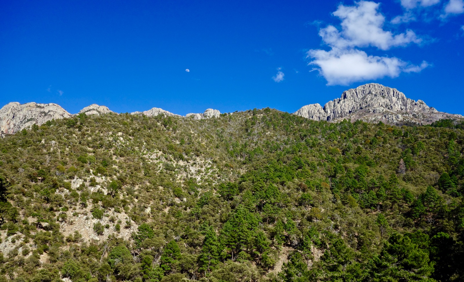
Visiting Quartz Peak is a celebratory celestial experience. Aptly named Butterfly Mountain rises a little higher over moon-white boulders. (THW, photo)
 
Route: The Quartz Peak Trail bears essentially north-northeast to Quartz Peak. Leave the trail and walk east on a ridge to Butterfly Mountain. The East Wing is accessible for scramblers. The West Wing is a technical climb. 

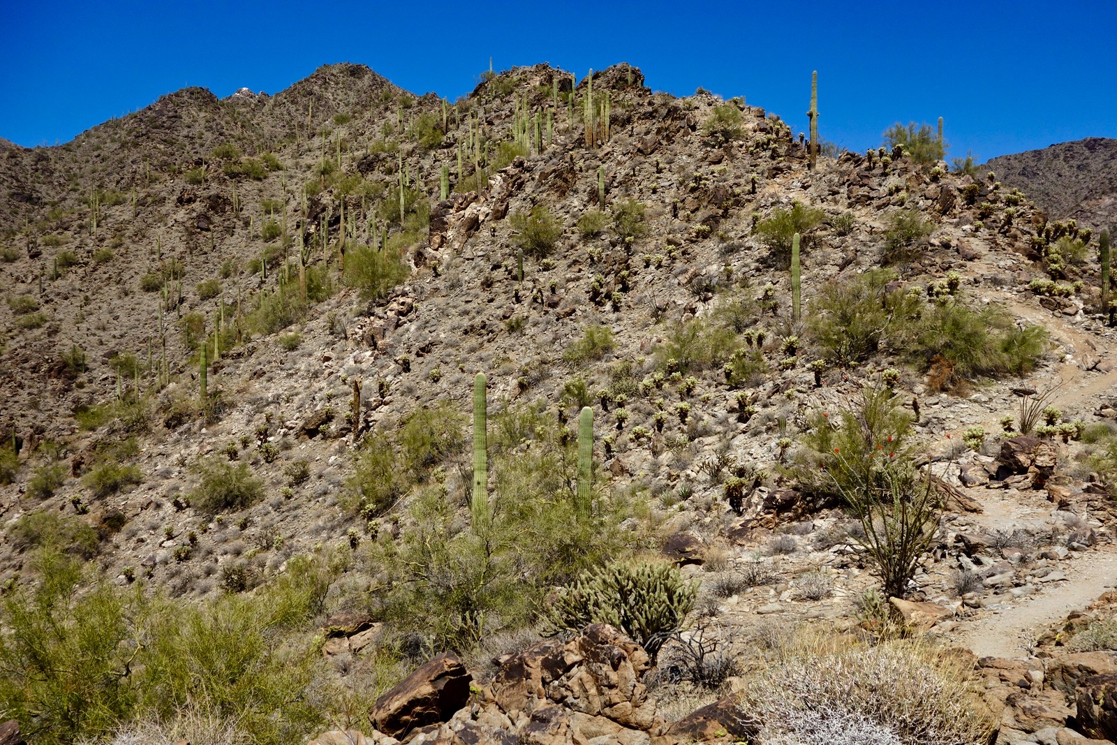
The Quartz Peak Trailhead is located on the floor of Rainbow Valley at 1,560 feet. According to the map placard, Congress designated 14,400 acres as Sierra Estrella Wilderness in 1990. The registration box is a few paces up the trail. This image looks back on the trailhead.

Quartz Peak
Walk northeast up a wide track. The twin summit on the horizon is Butterfly Mountain. The trail turns to the northwest, cairn stacks leading the way. A quartz boulder, blasts of mica light--the trail is positively shining. The pathway rises up the side of the first ridge, pictured. Begin the climb at 0.4 mile on a well-engineered platform dug out of the slope. Already there is a sense of remoteness. Our only company on this day is the Sonoran plant community and mind-blowing rock.

Gain the first of two access ridges at 0.6 mile, Benchmark 1,852'. Having climbed many desert mountains off-trail, the superbly constructed linear treadway with stone steps and retaining walls feels luxurious. The trail favors the west side of the ridge when it is not right on top. Start hiking in the early morning and you will be shaded from the powering up sun. Teddybear cholla crowd saguaro, ocotillo throw flames, a coyote is yapping away. The image below looks back on the first ridge, the parking lot visible. Southwest is Sevenmile Mountain, Peak 2,948' jutting sharply.

At 1.0 mile, elevation 2,290 feet, transition onto the second access ridge. Quartz Peak may be briefly glimpsed.

The ridgeline constricts to 15 feet, the treadway hemmed by boulders as it works both sides of the ridge. Trail builders had an eye for mythic beauty and Sonoran splendor.

At 2.0 miles, Benchmark 3,092', Quartz comes into view once again as the trail transitions onto the south-southwest ridge of the peak. Ascend a rocky outcrop on miniature switchbacks. 

The West and East Wings of Butterfly Mountain are often visible from the trail.

Trail engineering ends on Point 3,523 at 2.4 miles. From here, follow plentiful cairns as the route snakes around on the spine, never straying more than a few feet from the ridgecrest. The challenge increases from Class 1 walking to Class 2+ with very light scrambling. Quartz floaters lie on the surface as the route takes us right under the south-facing summit block. (THW, photo)

Luminous quartz boulders extrude from bedrock. Walk on the path of light.

There are multiple scrambling routes up the east side of the summit.

The rock is highly textured and embedded with mica mirrors.

Pass through white blocks adorning the crest.

The peak is a jumble of pure quartz boulders. From afar the crown looks like a star. But in its presence, stones are moon-white. Albedo renders their surfaces cool. Judging from the joyful mood conveyed in the summit register, people draw genuine happiness and elation from this particular place. Having grown up in the Sierra Nevada, quartz defined my childhood world. But I had never seen anything like this. (THW, photo)

Montezuma Peak, 4,354', is in the southeast quarter of the range.

It is 3.0 miles with 2,500 feet of vertical to Quartz Peak. Most visitors turn back here, and they should. Butterfly Mountain is a commitment well beyond the requirement of the Quartz Peak Trail.

Butterfly Mountain, East Wing
Quartz is not a ranked summit because there is only 275 feet of relief from the shared saddle with Butterfly, not the requisite 300. Allow at least one hour for the traverse from one mountain to another. Looking at the image below, downclimb from the summit block and skirt the first rock outcrop on the south before returning to the ridge.

The ridge looks rather intimidating from afar but is relatively friendly up close. Work the spine as you please, either right on top or just off on the south side. There is mild exposure in places.

At 3.3 miles, go over a knob. A new segment is revealed. Looking at the image below, on our way to Butterfly we skirted the ridge on the south side. Click on this image to see a tempting game trail (which soon disappears). On our return we stayed on the ridge, bypassing a couple of gendarmes. It took slightly longer but was more playful.

At 3.7 miles there is a boulder ball so massive you could mistake it for a butterfly wing. Walk along the southern base of this great feature.

There is little information on climbing Butterfly Mountain so, of course, we just assumed we'd be climbing both wings. But access up the West Wing did not look promising.

The west wall of the wing is well armored.

We circumnavigated looking for a route. The north side is thick with brush and the wall is sheer. The south side is the better route around the wing. We did not locate even a Class 4 scramble option. However, the East Wing looked appealing and well within our abilities.

It is a Class 3 scramble up the East Wing on solid rock with excellent holds. The exposure near the top is moderate. The wing sheers off sharply on both sides. My hiking partner is nearing a false summit.

Mount the East Wing. Fluttering over the diminutive summit were, appropriately, yellow butterflies.

The view was muted by haze and my unfamiliarity with the Phoenix region. To the east, the Gila River is very near the base of Sierra Estrella. Next is South Mountain, the highrises of downtown, Piestewa Peak and Camelback Mountain, and Four Peaks.

The image below looks back on the West Wing and Quartz Peak. The highpoint of Sierra Estrella is the red summit, image-right, Peak 4,512'. Locals refer to it informally as Hayes Peak. Ira Hayes was a Pima Native American and a member of the Gila River Indian Community. As a United States Marine he was one of the six flag raisers in the photograph taken on Iwo Jima during World War II. Hayes Peak (and Montezuma Peak) are on tribal land and permission must be obtained before climbing. "The Community is a closed-reservation which means the land is not open to the outside public. Right-of-entry permits are not issued for hiking." (From the tribal permit application.)

For the return, after passing the boulder ball stay on the lumpy ridge as best you can.

After skirting the rock outcrop, shown, you may forego Quartz, of course. We were compelled to go up and have another look around.

The descent on this particular trail is an unusual pleasure because you can see the footpath winding down the ridgeline well below.

A star and a butterfly are a most unusual pairing. But in the Sierra Estrella they commune together upon our sun-breathing Earth.

The winter of 2017-2018 has been historically dry. In March, wildflowers would normally be competing with rocks for our attention. Sadly, other than the Ocotillo torches, we saw one lupine, one wild hyacinth, and shrubby deervetch blossoming in the shade of the boulder ball.


Monday, March 26, 2018

Mount Wrightson, 9,453', and Josephine Peak, 8,478', Santa Rita Mountains

Essence: Circumnavigate and climb Mount Wrightson, indisputably supreme in the Santa Rita Mountains. Miles are rather long and the elevation gain is substantial but the superior trail mitigates the effort. On the Super Trail walk beneath dramatic south-side cliffs and columnar towers. The climb to Josephine Peak is off-trail and rugged. She is a sweet little grass-topped prominence with superior views of the big-boned bastion to the north. While crowds of people climb Wrightson every year very few ascend Josephine. Both hikes are within the Mount Wrightson Wilderness.
Travel: There are three Green Valley exits from I-19. Watch for a brown sign for Madera Canyon Recreation Area and exit on Continental Road. Turn east under the interstate and cross the Santa Cruz River. In 1.2 miles, turn south on White House Canyon Road which transitions to Madera Canyon Road. Cross three one-lane bridges. The Wrightson run-out zone is typical Sonoran--mesquite, palo verde, prickly pear and silver cholla. The paved road steepens sharply and ends in 12.8 miles at a multi-layered parking lot at the Madera Canyon Picnic Area. Loop around and park near the Old Baldy Trailhead located in the upper lot on the east side. Be sure to pay the day use fee ($8.00 in 2020), or display your National Interagency Pass.
Distance and Elevation Gain: 13.7 miles; 4,700 feet of climbing for both summits
Total Time: 7:30 to 9:30
Difficulty: Trail, off-trail; navigation moderate; no exposure; traction devices are necessary when snow and ice is present; wear long pants to protect against graythorn and brush on Josephine; water is usually present at Bellows Spring; it can be windy and cold on the summit so bring extra layers.
Map: Mount Wrightson, AZ 7.5' USGS Quad
Latest Date Hiked: March 26, 2018
Poem: 
Up where no overshadowing mountain stands,
Towards the great and the loftiest peak
A fiery longing draws me.

Petrarch, c. 1345

Climb Josephine Peak for an uncommon perspective on Mount Wrightson. The Super Trail rings the mountain and spans the image.

Route: Bear southeast on the Old Baldy Trail to Josephine Saddle. This description loops around Mount Wrightson clockwise because it is more aesthetically pleasing but you could go in the opposite direction. Stay on Old Baldy to Baldy Saddle and climb Mount Wrightson on the Crest Trail. Return to Baldy Saddle and link to the Super Trail, swinging south around the peak to Riley Saddle. Do the optional out-and-back to Josephine Peak and then go west on the Super Trail back to Josephine Saddle. Return on Old Baldy.

Study the informative map placard at the Old Baldy Trailhead, elevation 5,460 feet. Two trails climb to Josephine Saddle, Old Baldy (#372) and the Super Trail (#134). Old Baldy is direct (steeper) and shady. It is on north-facing, forested slopes. The Super Trail is longer (more gradual) and traverses south-facing, high-desert, arid slopes. While the map shows a trail to Josephine Peak (#132), don't be fooled. It no longer exists.

Begin walking south on the Old Baldy Trail which makes use of an abandoned road. It parallels one of the tributaries of Madera Canyon. Moon-white sycamore and Arizona Walnut edge the stream. Madera Canyon is a world renown destination for the birding community.  On this morning ornithologist John Bregar identified the following birds as we made our way up the trail: Mexican jay, Bewick's wren, red-shafted flicker, white-breasted nuthatch, dark-eyed junco, canyon wren, and spotted towhee. We did not see an elegant trogon on this day but they begin arriving in Madera Canyon from Mexico in the spring to nest. They favor deep sycamore canyons and Arizona madrone berries.

At 0.3 mile, Old Baldy curves sharply around to the left and segues onto a wide footpath interspersed with bedrock and stone water bars. All of the signs in the Mount Wrightson Wilderness are hand stenciled and artistic, created with a fine point acetylene torch.

Round a corner to the south and see the serrated north ridge of Wrightson, the Santa Rita Crest. Mount Ian, 9,146', is center-right in this image.

Through an opening in the trees the volcanic, solid stone crest of Mt. Wrightson is revealed.

The lower mountain is composed of a crystalline igneous granitic and here it momentarily spans the treadway.

The diversity, age, and girth of trees is a compelling feature of the Old Baldy Trail. On the lower mountain we passed by Southwestern white pine, longleaf pine, Chihuahua pine, ponderosa pine, and Apache pine. We saw silverleaf oak and this magnificent Arizona white oak. (THW, photo)

Reach Josephine Saddle at 2.5 miles, elevation 7,100 feet. I've always been curious about the naming of this location, a saddle between Mt. Wrightson and Mt. Hopkins. After all, the saddle between Mt. Wrightson and Josephine Peak is almost two miles southeast.

On the saddle is a memorial to three boy scouts who lost their lives in 1958 during a storm that "came out of nowhere" and dropped three to four feet of snow on the mountain. As we rested nearby two hikers, one of whom was on his 41st annual Mt. Wrightson climb, told us the tragic details with great animation. Sixty years later the story retains gripping power. Read the account in Death Clouds on Mount Baldy, by Cathy Hufault, a sister of one of the lost boys.

The Old Baldy and Super Trail meet in the saddle and share the footpath for the next 0.2 mile. Stay left for the clockwise route around the peak. The geology transitions to rhyolite volcanics in the Mount Wrightson Formation of the Middle Triassic age. Sandstone bodies are featured prominently on the east side of the mountain. They were deposited within the volcanics in quiet times between eruptions.

As the trail swings around to the northern slopes, the jagged-capped north ridge of Wrightson is featured. The narrow break in the cliffs that affords passage is image-center. The arc through the high basin is one of my favorite segments of the hike. As we approach the crinkled backbone, the desert floor rapidly recedes.

Switchback up the slope and approach the mountain's no-nonsense stone wall. Water was plentiful at Bellows Spring in March, 3.8 miles, elevation 8,150 feet. Don't count on it.

A relic aspen forest is symbiotic with blue elderberry at 8,200 feet. Rise a little higher and encounter limber pine. The trail is confined by crags and chutes so there is a series of tight zigzags.

Gain the north ridge at Baldy Saddle, 4.5 miles, elevation 8,780 feet. The presence of the mountain radiates ascendancy.

As the historic patina-coated sign indicates, several trails intersect at Baldy Saddle. To climb Mt. Wrightson, 0.9 mile off, turn right/south on the Crest Trail.

What follows is one of the finest passages up any mountain. The Crest Trail begins on the east side and wraps around to the north before taking a surprising jaunt to the south for the final approach. The generous north side platform is blown out of bedrock. It gathers snow and ice that often lingers well into spring. Now on solid rock with holding-the-earth-down kind of power, coupled with bird-like loftiness, there is an absolute knowing that one is approaching the highpoint of a Sky Island.

Nut-leaf oak cloaks the uppermost slopes on the south side of the mountain. The summit trail switches up between fanciful rock features. Crest the highpoint of the Santa Rita Mountains at 5.4 miles, elevation 9,453 feet. Upon the expansive summit is a concrete foundation, the remains of the Mt. Wrightson Lookout. An informative sign explains that a six-foot square fire lookout was active from the early 1900s until it was decommissioned in the late 1950s.

Mt. Wrightson was formerly named Mount Baldy. On February 17, 1865, William Wrightson and Gilbert W. Hopkins were working as surveyors for the General Land Office. The two men and a Mexican boy were traveling from a ranch in the Santa Ritas to Fort Buchanan, three miles west of Sonoita, when they were attacked and killed by Apache warriors. Mount Wrightson and Mount Hopkins were named in their honor.

Neighboring Mount Hopkins is two miles west. The Whipple Observatory, in various locations on the mountain, is owned by the Smithsonian Institution. The observatory complex is operated jointly by the Smithsonian and the University of Arizona in Tucson. At skyline in the west are Baboquivari Peak and Kitt Peak. (THW, photo)

The north ridge is accessed by the Crest Trail to Florida Saddle and on into Florida Canyon. Mt. Ian, and Peak 8,853' are the two ranked summits. Also visible is Tucson, Pusch Ridge, Mt. Lemmon, and the Rincon Mountains.
(THW, photo)

The trail system to the mountain is so well constructed it doesn't beat you up. So even after 4,200 feet of vertical many hikers are going to have something left for the Super Trail circumnavigation, if not Josephine Peak. Descend on the Crest Trail back toward Baldy Saddle.

The junction with the Super Trail is located just before the saddle, at 6.3 miles. It is only 1.5 miles longer than returning on Old Baldy but nevertheless carries far fewer people. Hang a hairpin to the right. In 2005, the Florida Fire burned the eastern slopes of the mountain. When I was on the Super Trail on January 1, 2014, there was deep snow and the trail was pretty impossible to follow. We crawled over deadfall and progress was slow.

Baldy Spring is just 0.1 mile from the junction. It has been an unusually dry winter in 2018 and the spring was effectively dry. The Douglas fir forest is a mix of standing dead, old growth, and a thickly packed post-fire tree nursery.

Arrive at the junction with the Gardner Canyon and Walker Basin Trail at 7.1 miles. The trail is on a lovely eastward ridge with very old trees. Round the corner to the south side of Wrightson and there is Josephine Peak looking like a real mountain.

The southern slopes of Wrightson are simply stunning. Rock fracturing created an array of squared-off towers that appear as vertical straight-edged columns. We had debated descending directly from the summit to Riley Saddle. I think we could have pulled it off but it looks troubled with brush and rock outcrops. Oak, manzanita, and graythorn encroach even on the Super Trail. 

Josephine Peak
Reach Riley Saddle at 7.9 miles, 7,940 feet. The 0.7 mile mostly off-trail and demanding hike to Josephine Peak will appeal to only a small percentage of hikers. It took us 45 minutes to climb and 35 to descend. A use trail barges through oak and manzanita. Find it!

The path skirts Point 8,008' on its east side and then disappears 0.2 mile from the saddle. The thrashing begins. Notice the rock outcrop in the image below. It is about 300 vertical feet off the summit. The easiest choice is to skirt the rocky nose on the left/east and then return to the ridge. If I had it to do over again I'd climb straight up the outcrop. Instead, we chose to explore the unseen west side.

We got hung out on a very steep talus slope with undependable rock and Class 3 scrambling. We climbed the somewhat exposed grey blocks.

Once back on the ridge it is straightforward. The only impediment are thick stands of young aspen. Crest Josephine Peak, 8,478', at 8.6 miles. After decades of waiting this was a happy moment for me. The view of handsome Wrightson from the small grass-covered summit is unparalleled. The peak register was placed in 2006 and only four pages in the notebook were filled. I was delighted to see Pete and Judy Cowgill's 2007 signatures. Pete and Eber Glendening wrote the definitive, Santa Catalina Mountains: A guide to the trails and routes, 1998.

The vantage point on Josephine (as short as she is) is surprisingly superb. Shown in the east are the Whetstone Mountains. The highpoint is Apache Peak.

Southeast is Miller Peak, center-right, and Huachuca Peak, center-left. Out of the frame, the Patagonia Mountains roll on south into Mexico where they partner seamlessly with ranges in the soft blue distance.

To return, drop off the summit ball then skirt the outcrop to its east before returning to the ridge at first opportunity.

Back at Riley Saddle turn west on the Super Trail. Look back for another angle on Josephine Peak.

Unique perspectives are gained by circling Wrightson. Thick stands of Emory oak thrive on the southwest slopes and are working their way up into the cliffs. 

The dirt trail makes long, smooth switchbacks down a west-facing wooded slope where we saw a solitary white-tailed buck. Pass under an upended layered igneous outcrop.

Close the loop at 11.0 miles at the junction with the Old Baldy Trail, just 0.2 mile up from Josephine Saddle. We descended on Old Baldy because we wanted to snap photos of the trees. But if you have the time and energy you could extend your hike by staying on the Super Trail back to the trailhead, adding 1.2 miles.

Seen from Madera Canyon Road, Mount Wrightson is resplendent in afternoon light. People often fall in love with this mountain, many seeking to repeat the climb one hundred times.