Travel: From I-10, take Exit 297, Mescal Road. Measure from here and drive north on Mescal Road, a paved two lane. Pavement ends 3.2 miles from the interstate. Transition to FSR 35 at 4.3 miles. It is a graded and wide roadbed prone to washboard. Wind up Ash Creek which drains the Little Rincon Mountains on the east and the Rincon Mountains to the west. Pass Ash Creek Ranch at 7.2 miles. Ford Ash Creek two times. The first and deepest crossing at 8.1 miles may require 4WD with high clearance. Hang a sharp right into a circular parking area west of Ash Creek 10.1 miles from I-10.
Distance and Elevation Gain: 10.0 miles; 2,700 feet of climbing
Total Time: 7:30 to 9:00
Difficulty: A sparsely cairned, barely visible trail to Hidden Pasture, then off-trail to the peak; navigation challenging; Class 2+ scrambling and bouldering; no exposure; stream is intermittent and contaminated so carry all the water you will need.
Map: Galleta Flat West, AZ 7.5' USGS Quad
Latest Date Hiked: December 17, 2018
Quote: The path is made in the walking of it. Zhuangzi, b.369 BCE
The spheroidal nature of granitic boulders, rock stacks, towers, and walls is the compelling feature of this challenging hike.

Route: Navigate northeast on a disappearing trail, primarily on the southeast side of an unnamed northwest tributary of Ash Creek. There is a mile-long stretch of streambed walking. Upon reaching Hidden Pasture climb north to Forest Hill. Return as you came.

To Hidden Pasture
From the parking area at elevation 3,980 feet, walk up the track a few paces under sycamore trees and towering mesquite. Ranching is widespread in the region--damage and water contamination from cattle is extensive. Cross Ash Creek on boulders as best you can. Then, find any passage through the thorny brush while ascending about 60 feet up the hill to a fence line. Outdated websites reference a trail up the slope but it has disappeared. Follow the barbed-wire fence north keeping it on your right. There is a rough fence line trail. (Note for the return: this tempting trail will not lead you back to the parking area.) Pass through a gate at 0.2 mile, 4,040 feet. It is essential that you locate this gate for the old trail leads on from here.

Enter a spheroidal world. Raised up 30 to 40 million years ago the Little Rincon Mountains expose a melange of geological formations. While there is some surface schist, the weathered rock is composed of a range of granite suites. The igneous granitics include coarse grained intrusive rocks. You will find multiple scatters of large quartz nuggets.
The lower vegetation zone is Apache Highlands Grassland. Hidden Pasture and Forest Hill are within the Evergreen Oak Woodland zone. Typical vegetation includes dyebush, mammillaria cactus, yucca, cholla, shindaggers, sotol, resurrection moss, and ocotillo. There are unavoidable nasty thorny shrubs so wear long pants. The recent invasion of buffelgrass, a non-native noxious weed, has contributed to the demise of the trail.
Given the name Hidden Pasture I wondered whether the route was once an established stock trail but I couldn't find any history on that. If you know, please comment. Be intently watchful for cairns, typically just one stone on a boulder. Thankfully, someone went to a lot of effort to mark the route all the way to Hidden Pasture. There are trail fragments associated with some cairns.
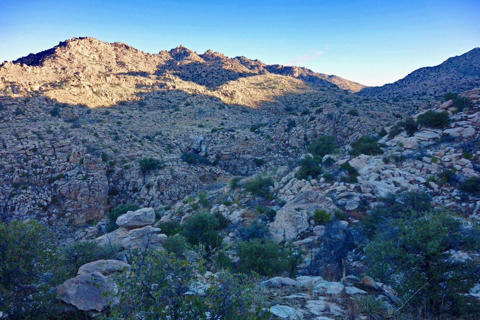
Ascend to a shelf southeast of the canyon. Go up a shallow draw at 0.4 mile. The string of pinnacles and stony knobs on the opposite side of the canyon is the undulating southwest ridge of Forest Hill.
The trail hangs above the canyon at 0.6 mile. It is a dramatic spot with a view of Rincon Peak so far above and the tank-filled waterway cutting a sharp curve below.

The first barrier fall encountered by those hiking up the creek is depicted below, image-center.
Streambed Alternative
In February, 2014, my partner and I didn't know about the standard route so we attempted to reach Hidden Pasture by scrambling up the canyon bottom. There is no trail, it's boulder hopping all the way. If you intend to follow the streambed to Hidden Pasture, from the parking area make your way up Ash Creek to the confluence with the tributary and enter there. The canyon is an exquisitely beautiful and profoundly rewarding stone corridor. The one caveat is an abundance of vicious, shredding catclaw. This image is unusual because it shows the one and only saguaro in the entire region east of the park. (That I know of.)

Here is an image of the fearsome-looking pouroff mentioned above. Bypass upcanyon-left. (THW, photo)

The top of the dropoff is white granite, smooth and still.

Standard Route
The rim trail descends to the canyon floor at 0.8 mile and crosses the creek. The route follows the stream for just 0.2 mile before climbing out of the drainage. Pass a classic barbed-wire fence at 1.3 miles. It is no longer maintained and the gate is open. (THW, photo)

At 1.7 miles, 4,400 feet, the path intersects the creek again. It took us about an hour to cover this initial segment. Memorize the configuration of this location so you don't blow by it on the return. This image was shot looking back at the trail and a couple of short-stack cairns, image-left.

Beside the stream is a distinctive water pocket surrounded by stone sheets exfoliating in unusual flaked scallop patterns.

Work your way up the creek on either side for the next mile. In 2018, the impacts of cattle left the water with an orange-tinge, a bad smell, and choked with algae. Still, sculpted bedrock makes this passage a delight.

Ribs of granite run horizontal to the flow. Multiple generations of Tertiary faulting caused significant tilting of rocks. (THW, photo)

We followed adult cougar tracks all the way to the bypass where we lost his prints but happened upon piles of recent bear scat. We saw no footprints, not even old ones, on the entire hike. If you are looking for solitude, this is the ticket. (THW, photo)

The blade pool. (THW, photo)

Cairns lead out of the wash on the southeast side at 2.7 miles, elevation 4,600 feet. This 1.1 mile bypass runs all the way to Hidden Pasture. This is the most challenging segment of the hike to navigate through boulders and towers, and ridges of rock. Climb a hill and on a knoll there is an old fence and a fallen gate. Notice the handbuilt wall crafted with massive blocks. In the canyon a natural wall spans the chasm. This is the second pouroff encountered on the inner canyon hike. There is a big pool at its base. (THW, photo)

Streambed Alternative
A reflection pool is located between the first and second waterfall.

The second pouroff may be bypassed without difficulty upcanyon-left. (THW, photo)

Standard Route
The trail drops slightly and comes very near the third and final cascade. Every once in awhile, my navigation fails me. In 2014, I didn't have a map or a GPS to help locate Hidden Pasture. After hiking for 2:40 we came to a lovely flat little valley and assumed incorrectly that we were in Hidden Pasture so we turned around there. Rather, it was 0.2 mile above the second fall and quite near the third pouroff, shown below. I can't promise you will be able to negotiate the last barrier fall but it looks simple enough. If you get foiled, just hop on the nearby standard route.

The bypass continues traversing beyond the third fall overlook. Then it drops slightly into a side ravine, turns sharply east and pitches up a draw to get around a substantial stone uplift. There are monster spheroids, pinnacles, and blocks on hiker's left. It is powerful and pleasant. Walk in front of the slab, shown center-right. See the feature photo for another perspective on this location.

Stay dialed on the single-rock cairns and finally pass by a blade where the route tops out at 4,960 feet, 3.3 miles.

Here's another perspective on the blade. The route makes a tight turn to the north at the blade and holds this bearing all the way to Hidden Pasture.

The image below was shot on the return and looks back at the stone ridge. The blade is at its left end in the middle distance. Heading north to the Pasture, walk down the slope and mount the rise from where this photo was taken.

At the top of the rise, Forest Hill is visible for the first time, image-left.

The canyon opens into Hidden Pasture, a broad bowl of grass and oak. It is cradled between the two blocks of the Little Rincon Mountains. Forest Hill, image-center, is north of the Pasture and North Star Peak is south. Ironically, there is no evidence of cattle in the Pasture.
Arrive at the sandy wash on the valley floor at 3.8 miles, 4,900 feet. Elevation gain to this point is 1,200 feet. No matter how strong a hiker, it takes a good amount of time to pause and decipher the route. It took us almost three hours to reach the Pasture. We shaved a good 20 minutes on our return to the trailhead. There was still a lot of hesitation and searching around for cairns but the trail was slightly more obvious returning in better light. Plus, we were getting the hang of it. (THW, photo)

Forest Hill
Roundtrip to the highpoint is 2.4 miles and will take two to three hours. Aim north-northwest for the high saddle just west of the peak. The two rocky knobs west of the saddle are troubled. There are many possible routes up through the jumbled and complicated terrain. Going up we stayed to the right of the side creek but the hillside is boulder-filled and the grasses and brush were so thick we couldn't see our feet.

Our return route, depicted on the map above, is more aesthetically appealing and fun. A significant side drainage comes down from the saddle. It is choked at the bottom so head up through the grass on either side and once it's clear, dive into the drainage.
Work up through the boulders and scoured bedrock slabs staying in the watercourse as much as possible. This route is one of the finest features of this hike. Bypass a couple of impassible pouroffs upcanyon-right. (THW, photo)

Coral bells tucked in protective rocks bloom in mid-December.

Southwest coral bean is a thorny shrub that blooms spring to late summer. The flower is bright red and showy. The poisonous seeds within the legume pods are the same color as the blossom. (THW, photo)

Emerge from the drainage and onto an open slope at about 5,400 feet. Climb another 500 feet with decent footing to the saddle.

Hop over an old fence tracking the ridge and gain the saddle at 4.8 miles, 5,900 feet. My partner climbed the pink knob, shown. He said there are two good routes on the west side, a Class 3 and Class 4 option. The climb is almost vertical but the holds are good all the way up. The little ridge going west from there is problematic.

The pink knob affords the best vista of Forest Hill. For perspective, I am standing at the base. (THW, photo)

The pitch up to Forest Hill is the most enjoyable climbing of the day with light scrambling. It is a relief to pass through a piñon and oak forest. Is the peak named for this stand of trees? I researched the history of the rather odd name but came up empty. If you know, please comment. Crest the highest point in the Little Rincon Mountains at 5.0 miles after 2,480 feet of vertical. The sweet summit is topped with a five-foot block. There are good sitting rocks but no peak register. (THW, photo)

Rincon Peak, 8,482', with its pyramidal apex and landmark status dominates the westward scene.

However, Mica Mountain, 8,664', is the parent summit. Other notable mountains off-image include Bassett Peak in the Galiuro Mountains and Mount Graham. (THW, photo)

We intended to climb North Star Peak, shown, on this day but this hike took considerably longer than we anticipated and the Winter Solstice approached. Perhaps in the spring. South of North Star is Apache Peak, the highest prominence in the Whetstone Mountains. This photo is actually a good shot of Hidden Pasture and the bypass.
(THW, photo)

We look forward to further exploration in this neglected little range. We'll be creating our own pathway through irresistible stone as we walk. As you complete the trek Rincon Peak will be resting under its sky in afternoon light. (THW, photo)

I truly admire your passion for the outdoors. I spent a lot of time in the Organ mountains as a boy and I still want to return to those hidden grottos and streams we discovered. There was for me a magical and spiritual aspect of being when immersed in those great outdoor realms. The photos are breath taking as well. I would love to know what camera you use for your blog as the photos it takes are exactly what I like in digital format. I hope you continue to share your quest with us as I have bookmarked your blog and look forward to each new posting. J. Mason
ReplyDeleteThank you, J. We're out there for the same reasons--insatiable curiosity about our Earth and communion with Nature. I'm shooting with a rather old Sony RX100. My partner, the better photographer (Thomas Holt Ward), is using a Sony Alpha 5100. I process my images with the standard Apple Photos editor; he uses Affinity Photo. Hope to meet you out in the wild some day. Debra
DeleteThank you Debra. I am not surprised since those are indeed great cameras. Happy Trails!
ReplyDelete