Travel: In Tucson, drive to the east end of Speedway Blvd. and turn right into the Douglas Spring Trailhead parking lot. Post your National Parks pass if you have one (not enforced in 2018). This is a popular neighborhood trail system; if the lot is full park on the south side of the approach road. No facilities, no water.
Distance and Elevation Gain: 8.0 miles; 1,700 feet of climbing
Total Time: 4:00 to 5:00
Difficulty: Trail, off-trail; navigation moderate; Class 2+; no exposure
Map: Trails Illustrated No. 237, Saguaro National Park
Date Hiked: December 15, 2018
Quote: And this, our life exempt from public haunt, finds tongues in trees, books in running brooks, sermons in stones, and good in everything. William Shakespeare
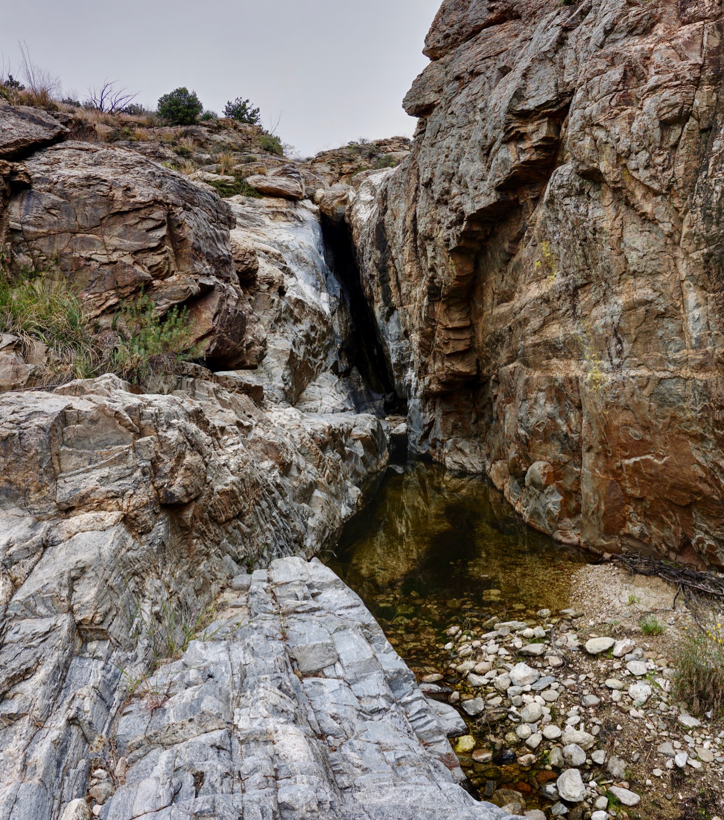
The monochromatic character of stone above and beyond Bridal Wreath Falls is accentuated under sun-defeating clouds. The air untroubled, walking in an envelope of silence, the nearby tumultuous city seems very far away.
(Thomas Holt Ward, photo)

Route: For this stem and loop, hike east on the Douglas Spring Trail (DST) and branch right on the Bridal Wreath Falls Trail. Continue off-trail up the canyon to Tina Larga Tank. Return on the DST. Hike off-trail in the lower canyon either coming or going.

From the trailhead, elevation 2,749 feet, walk east on the DST. The entire hike is within Saguaro National Park, therefore no dogs or bicycles are allowed. The destinations and connecting trails are almost unlimited within the maze.

The national park's trail maintenance crew works most of the winter. The treadway is broad and buff. Sonoran splendor is as it should be in the national park. Saguaros commune with barrel cactus, mesquite, palo verde, a variety of cholla, prickly pear, bursage, creosote, and brittlebush. There's an ocotillo grove further up the trail and dyebush blooms in their presence.
Sign the register at 0.2 mile. The Garwood Trail branches south in a few paces. Walking east, the landscape rises all around. To the north is Agua Caliente Hill and then Pusch Ridge. South is the Rincon Mountains. In repose under a mantel of heavy clouds is the stony summit of Tanque Verde Peak.

The Converse Trail branches right at 0.7 and then the track begins climbing gently up a deeply embedded boulder staircase. This just feels like a very old and regal trail. Some steps have log risers and others are chiseled into bedrock.
We happened upon a park volunteer who was going to hike south on the Carrillo Trail at 1.7 miles. He was doing the popular Garwood Loop: south on the Carrillo Trail, west on the Three Tank Trail, south on the Wildhorse Trail, west on the Carrillo Trail to the Garwood Dam, and north on the Garwood Trail to the DST.
Descend to an unnamed wash at 1.8 miles, 3,400 feet. I highly recommend walking through this beautiful watercourse on your way up or downcanyon.

The trail tracks along the north side of the drainage heading east. The wall beside the trail is composed of scoured and colorful rock with big crystals. This image looks into the lower canyon. Bridal Wreath Falls canyon is left of the cottonwood tree. Helens Dome on Mica Mountain is image-left. (THW, photo)

Recross the lower canyon at 2.2 miles, elevation 3,600 feet. This is where we hopped into the drainage on our return. Note that this canyon does NOT lead to Bridal Wreath Falls so if you are ascending in the channel, get back on the trail here.
The Three Tank Trail branches south at 2.5 miles. At the next signed junction, 2.7 miles, the trail to Bridal Wreath Falls takes off to the right. Ernie's Falls is left. I've heard it described as a "tight little fall with one big drop." We're pretty sure it's not running so we leave it for another day.

Walk through a mesquite forest. Buffelgrass blankets the ground. The Saguaro National Park website states, "buffelgrass is the archenemy of the Sonoran Desert, the invasive grass most likely to cause significant damage to the native ecosystem."

Reach the base of Bridal Wreath Falls at 3.0 miles, 3,800 feet. The day we visited there was only a minimalist flow. My partner returned in March, 2019 when the falls were running. (THW, photo)

Bypass the pouroff on a social trail upcanyon-left.

Climb the pitch with assistance from the roots of a massive mesquite. There's something about climbing trees--such a blast. While there is a little scrambling further on, this is as big as the challenge gets on this hike. (THW, photo)

Stair step up the stone corridor on water polished bedrock. I am enamored by the texture, the color, and sheer volume of exposed stone. The Rincon Mountains are a highly eroded mass of bedrock referred to as a metamorphic core complex. The altered granitics seen here form much of Tanque Verde Ridge. They are 1.4 billion-year-old metamorphosed basement rocks. (THW, photo)

Scale an ancient gray wall. (THW, photo)

Some pretty good scrambling awaits. Be watchful and stay in the main drainage. Even in December hummingbird bush and coralbells, shown, are blooming. It is soundless and serene and inconceivable that we are only a few miles out of town.

Scramble through a boulder garden.

Ascend a clean rock plate. (THW, photo)

Bypass an incision holding up a chockstone at 3.5 miles. (THW, photo)
The creek swings east above the crack. Note that the 7.5 topographical map indicates a couple of link trails in this area. They no longer exist so continue creek walking past a series of pools and shallow tanks. We saw both cougar and deer tracks in the sand. (THW, photo)

Swing around for an elevated view into town and over to Cathedral Rock.

Bypass a reflection pool enclosed between two water-softened barriers. (THW, photo)

The Tina Larga Tank is a stacked stone and cement affair, impossible to miss at 4.0 miles, 4,300 feet. A good portion of the tank has been swept away. While this is our turn-around location, you could certainly continue bushwhacking upcanyon. The DST is just six feet away, upcanyon-left. (THW, photo)

Turn left on the trail and hike consistently downhill. There is a good view shot to the Tucson Mountains and Kitt Peak. Close the loop at 5.2 miles, staying on the DST. If you have not already been off-trail in the lower canyon, leave the trail at 5.7 miles, elevation 3,600 feet where it crosses the wash. Do not miss this glorious half-mile segment. If you are unsure about your canyon-scampering abilities, the lower canyon is the easier of the two presented in this discussion. Glide down white and gray burnished bedrock. (THW, photo)

Pass through the black and white sector.

The canyon takes a dive at 3,480 feet; do a Class 2+ downclimb in the center of the throat. (THW, photo)

Shown below, the drop is pretty tame. Be watchful for the DST crossing the waterway at 6.2 miles. Turn left and return to the trailhead. (THW, photo)

Wish I knew about this a few weeks ago. We turned around at the Falls. Still had a great day!
ReplyDeleteWe just went back and did the whole hike up the canyon. It was early November and the Falls were basically dry. The stream had pools in places. Scrambling was a little tougher than we expected, so was route finding. But it was beautiful. Thanks for the suggestion!
ReplyDeleteLarry, I'm pleased you returned and did the entire hike. I appreciate the comment about your personal experience. Debra
DeleteIf you're interested, here's my account of the hike: https://daringdayhikes.home.blog/2022/11/23/bridal-wreath-canyon-saguaro-np-east/ . I gave your hike a shout-out.
ReplyDeleteYour story about your Bridal Wreath hike is simply delightful, thank you. I had fun poking around in your blog. Keep writing! Debra
Delete