Thursday, April 11, 2019

Tower Peak, 4,170'; Point 4,063'; Bushmaster Peak, 4,110', Tucson Mountains

Essence: This delightful and rewarding half-day circuit visits two ranked summits and one prominent point in the Tucson Mountains just north of Gates Pass. For those who have traveled time and again over the pass the extended summit ridge of Bushmaster Peak is enticing. While there are helpful segments of social trail most of the hike is off-trail on a rubbly surface. All three summits are inexplicably neglected; you are unlikely to run into anyone. These peaks are close to the road and on the western perimeter of Tucson but it's wild country out there.
Travel: West of I-10, Speedway Boulevard becomes Gates Pass Road at the intersection with Camino de Oeste. Take Gates Pass Road for another 2.4 miles and, just before the pass, turn right into the Scenic View. Park in the upper lot. There is a stone bathroom built by the Civilian Conservation Corps and informational placards but no water. No fees. Dogs are not permitted on trails.
Distance and Elevation Gain: 4.3 miles; 1,850 feet of climbing
Total Time: 3:30 to 5:00
Difficulty: Trail, off-trail; navigation somewhat challenging; minimal exposure; carry all the water you will need and hike on a cool day.
Map: Trails Illustrated, Saguaro National Park, No. 237
Date Hiked: April 11, 2019
History: The Bushmasters were members of the 158th Infantry Regiment, foot soldiers of the Arizona National Guard. The first volunteer infantry in Arizona was organized in 1865 during the Apache Wars. They served abroad in World War I, World War II, and Afghanistan. General Douglas MacArthur said of the Bushmasters, "No greater combat team has ever deployed for battle."

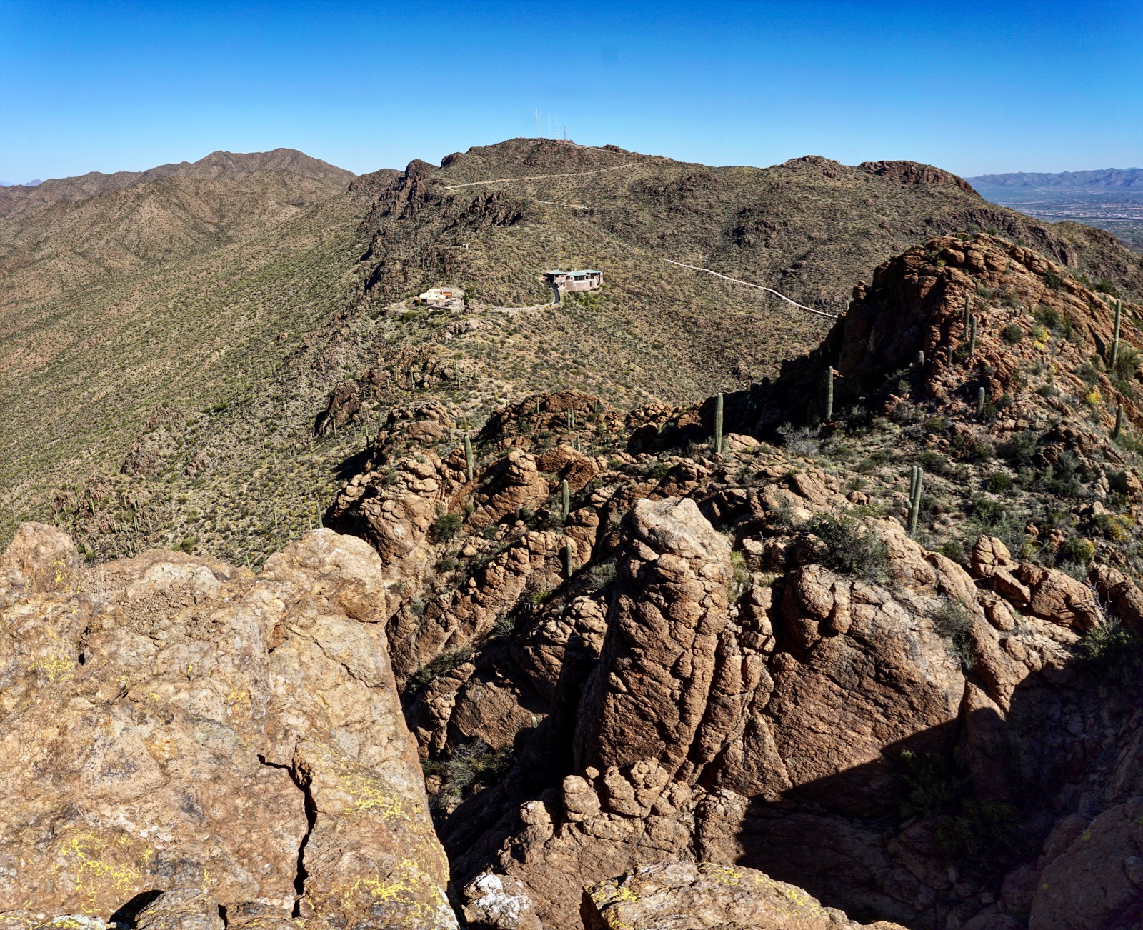
As viewed from the west end of Gates Pass Road, Tower Peak, Point 4,063', and Bushmaster Peak share a common rugged volcanic ridge.

Route: From Scenic View parking hike north-northwest up the south ridge of Point 4,063'. Flank the prominence on the west and climb the south ridge of Tower Peak. Upon completing the spur climb Point 4,063'. Descend on its east ridge and then flank Bushmaster's west ridge on the north and climb up a weakness to the summit ridge. Walk east over Bushmaster to a prominent knob. Drop down a northeast slope and then a southeast draw to the bajada. Walk southwest to close the loop.

Looking at the south wall of Bushmaster from Scenic View, the highest point on the ridge is at the center. The topographical map locates the peak on the east knob. I can't speak to the discrepancy but this hike takes in the entire ridge. Visitors stand within the Bushmaster memorial site.

The commemorative plaque was dedicated in 1989 to all who served as Bushmasters. The mountain is depicted and a snake is curled around a sword. Bushmasters are venomous pit vipers found in Central and South America. The name refers to one of the Three Fates in Greek mythology who determined the length of the thread of life.
(Thomas Holt Ward, photo)

South Ridge of Point 4,063'
There is little information posted for climbing the three peaks so we figured it out as we hiked. First, we wanted to ascend the south ridge of Point 4,063' if possible. That proved both elegant and beautiful. From the parking lot, elevation 3,150 feet, walk up a road cleaved from bedrock to the tiny cabin built by the CCC. The Corps employed 240 men between 1933 and 1941 to construct the improvements in Tucson Mountain Park. Stone structures were intended to blend into the natural landscape. This building has a fireplace, stone table and benches, and log roof. Sadly, it is sullied by graffiti.

Not surprisingly, a social trail heads north on the ridge, at times tracking along the east side. When it braids just stick to the thread closest to the ridgeline.

This segment is an engaging stroll through ash-fall tuff and breccia. The geology of the Tucson Mountains is a jumbled mass of volcanics. Limestone, granite, rhyolite, and schist are also present. The pattern is so confusing and incongruous the formal geologic name for the region is Tucson Mountain Chaos. Examples of all these formations may be seen throughout the hike. (THW photo)

At 0.8 mile, the south wall of Point 4,063' presents something of an obstacle. Stay on the clear and cairned trail as it veers west to flank the peak.

In another tenth of a mile stand on a platform that juts westward. When options diminish I always pause and consider, if I was a trail where would I go? Here, I'd make use of the ramp pictured above my partner's orange cap. To get over there the trail has to contour on a steep slope. The path is thin, the surface loose, and some hikers will feel a mild sense of exposure until they get on the ramp.

Top out in a relaxed and broad space. We stopped here and considered which peak to climb. We'd assumed we would hit up Point 4,063' first but we were already a tad north of it so Tower Peak went to the top of the list. Segue to the south ridge of Tower, still on a wildcat trail.

Tower Peak, UN 4,170'
Make your way to the shared saddle between Tower and Point 4,063' at 3,910 feet. The trail ends here and it is climber's choice up to the summit block. No matter how you work it, getting to Tower is messy. We stayed as close as we could to the ridge on our ascent. This approach had some good scrambling but was infested with punishing thorny plants: catclaw, hackberry, white-thorn acacia, and teddybear and buckhorn cholla. Therefore, I recommended our return route. Track under the slab, image-right, and then power up the scrabbly steep slope. It is not pleasant but it works.

There is one and only one weakness in the cliffrock. A large cairn directs but the way is obvious. I am pretty sure this is the only non-technical route up the mountain.

Crest the summit at 1.4 miles. As befits the name it is a small zenith, the collection of sitting stones surrounded by dramatic drops and standing rocks. The view north is marred by a luxury villa in a most unfortunate place on the boundary of Tucson Mountain Park. Trails End Estates penetrates to the base of the mountain on the east. But there is a good view of the Tucson Mountains, especially of Wasson Peak, the tallest of them all. The peak register was placed by the Southern Arizona Hiking Club in 2005. (THW, photo)

Curious about how we'd climb Bushmaster, we took a good look at it from here and decided to explore the unobstructed gully on the north side of the west ridge, shown, a superb choice as it turned out. Point 4,063', our next objective, is image-right.

Point 4,063'
Retrace your steps on the Tower spur and once in new territory climb the northwest ridge of Point 4,063'. It is an untroubled experience and you will see fragments of use trail. Skirt the summit block on the northeast.

Do a low Class 3 clean block scramble to the top at 1.9 miles. It is a playful little feature. This prominence is the easiest of the three and would be attainable by most hikers as an out-and-back. Look right down on Gates Pass.

This image was shot from the summit boulder looking back on the route choices to Tower Peak.

Bushmaster Peak, UN 4,110'
Point 4,063' is located at a split in the ridge. The route now pivots onto the spine running east. Stay on top of the ridgeline as it goes right over a knob. The ridge is thin in places but it doesn't feel exposed.

In early April, Schott's Yucca was in full blossom looking primitive as usual. (THW, photo)

Arrive at the saddle at 2.3 miles, elevation 3,810 feet. (Bushmaster just makes the 300 feet of lift necessary to be a ranked legal summit). At the base of the stone wall the approach is over. You have two choices for the climb. The more challenging route pitches up on the south side of the west ridge into the headwall chutes. We decided to stick with the plan we formulated on Tower and it turned out to be the definition of pleasant. From the saddle locate a use trail that gets you around to the north side of the west ridge. There may or may not be cairns--just use your best judgement and stick close to the base of the north-facing wall until you come to the all-important break in the cliffs.

In this image I am entering the break. (THW, photo)

Big rocks are well seated in the weakness and create natural stairsteps. It's steep but not too steep. This is one of the better gully climbs out there.

Break out of the gully at 4,020 feet. Bushmaster is dead ahead. There are two knolls on either side. We climbed the one on the west for a complete summit ridge experience. (THW, photo)

Walk east along the top of the escarpment, an exhilarating cruise. I've included this shot down one of the headwall chutes for those who want to pitch up the gnarly way.

There are plenty of good sitting rocks on the roomy rounded summit at 2.8 miles. The Bushmasters may take pride in this beautiful mountain overlooking their plaque at the Scenic View, Gates Pass Road, and Bren Benchmark and Golden Gate Mountain. (THW, photo)

Descent Route to Scenic View Parking
The traverse to the east end of the narrow summit ridge is sublime on big solid blocks. Mount the east knob. We wanted to downclimb the outcrop but we couldn't see the base of the climb and thought better of it.

That was a good decision. We got a much better look at the east end from below and it was out of our league.

From the east knob back up about 50 feet into a notch and then follow a cairned route leading onto the northeast slope. (THW, photo)

Pick your way down while aiming for an obvious saddle.

 As slope descents go, this is a good one with natural big rock steps.

Reach the northeast saddle at 3,710 feet. There's only one way out from here and it is kind of a pain. Plow down the draw bearing southeast. It's loose and full of brush, time consuming and laborious.

We happened upon a dried up a little catchment dam at 3,200 feet and left the draw heading southwest losing elevation as we crossed the bajada. We were attracted to a stand-alone granite boulder and went over to check it out. Sure enough, there were six herky chain anchors on top. You can freestyle from here to the parking lot. We wanted to look at a CCC building so after crossing a dry wash we got on an abandoned road (right turn), intersected a trail, (left turn), went up and over a hill for fun, climbed a rock stack (even more fun), and there was the stone structure, an abandoned bathroom with a charming row of windows. 

A couple of weeks before doing this circuit we hiked from Golden Gate Mountain to Cat Mountain. We were so taken by the Tucson Mountains that we kept coming back to explore everything that tempted us. We covered a fair amount of territory (with more peaks still on the wish list). Here's a look at Point 4,063' and Bushmaster from the north side of Bren Benchmark. (I managed to place the saguaro right in front of the highpoint!) We took one look at those peaks and just had to satisfy that longing right away. And so it goes...on and on.

Tuesday, April 9, 2019

Lemmon Pools and Marshall Peak, Northwest Summit, 8,300'

Essence: This hike showcases multiple features on the south flank of Mount Lemmon. Explore the jumbled and constricted channel of Lemmon Creek whose massive boulders force repeated probes and bypasses. Or, take a wildcat trail to the best pool of them all. Walk through the upper reaches of Wilderness of Rocks, an enchanting maze of free-standing granite stacks, sentinels, balanced rocks, and climbing boulders. Finally, incorporate a climb to the northwest summit of Marshall Peak while completing a popular forested loop that originates in Marshall Gulch. Spend the day in the Santa Catalina Natural Area enclosed within the Pusch Ridge Wilderness, managed by Coronado National Forest.
Travel: Measure from Tanque Verde Road and the Catalina Highway. Drive to Summerhaven, passing the Palisade Visitor Center at 24.5 miles and Loma Linda Road at 28.8 miles. In Summerhaven public restrooms and water are available at the Mt. Lemmon Community Center on the right. Enter the National Forest at 30.3 miles. The Marshall Gulch Picnic Area is closed seasonally between December 15 and March 1. Inexplicably, in April of 2019 the gate was closed and locked. Park at 30.6 miles and walk down the road. If the gate is open, drive another 0.6 mile to the trailhead. Pit toilets, no potable water. No dogs beyond the Marshall Gulch and Aspen Trail Loop. Pay the fee ($5 in 2019) or display your Interagency Pass.
Distance and Elevation Gain: 10.6 miles from the upper gate; 9.4 miles from Marshall Gulch Trailhead; about 2,500 feet of climbing. Allow additional time and distance for creek exploration; your stats will vary.
Total Time: 6:00 to 7:30
Difficulty: Trail, off-trail; navigation moderate; some exposure bouldering in Lemmon Canyon.
Maps: Mt. Lemmon, AZ 7.5' USGS Quad, or, Pusch Ridge Wilderness, Coronado National Forest, USDA Forest Service, 1:24,000
Date Hiked: April 9, 2019
Quote: This was the Earth of which we have heard, made out of Chaos and Old Night. Here was no man’s garden, but the unhandseled globe. It was not lawn, nor pasture, nor mead, nor woodland, nor lea, nor arable, nor wasteland…Man was not to be associated with it. It was Matter, vast, terrific…rocks, trees, wind on our cheeks! The solid earth! The actual world! Contact! Contact! --Henry David Thoreau

The star of the show in Lemmon Canyon is a rock-walled pool. A waterfall effortlessly and ceaselessly carves away at metamorphic Santa Catalina gneiss. (Thomas Holt Ward, photo)

Route: There are several points of access and both short and long loops on the south slopes of Mt. Lemmon. This hike begins on the Marshall Gulch Trail and bears west-northwest to Marshall Saddle. Hike southwest on the Wilderness of Rocks Trail to access the Lemmon Canyon pools. Return to Marshall Saddle and hike south on the Aspen Trail. Climb off-trail to the northwest summit of Marshall Peak. Return to Marshall Gulch on the Aspen Trail.

If the gate is closed, elevation 7,580 feet, walk down the paved road. This is a no-regrets dramatic warmup. Channeled Sabino Canyon creek barrels down the gorge squeezed between asphalt and sheets of granite.

The Marshall Gulch Picnic Area in upper Sabino Canyon is among the most favored in the Catalinas during summer months. It is moments from the hamlet of Summerhaven and less than an hour from sweltering Tucson. Walk across the (thundering) creek to picnic tables shaded by soaring pines. The Marshall Gulch Trailhead, elevation 7,440 feet, is located near the restroom. The 0.6 mile segment from the gate to the trailhead is reflected in subsequent mileages.

The trail kicks up initially and then eases into a gradual climb on the north side of the gulch. Enter the Pusch Ridge Wilderness. The 2003 Aspen Fire ripped through this region and there are massive scorched trees on the ground and spiraling into the sky. Survivors include Douglass fir; ponderosa, limber, and Southwest white pine; Arizona alder; bigtooth maple (return in the fall); and a variety of oak.

Cross the stream at 0.9 mile and climb a series of steps. The stone risers and boulders on either side of the trail are composed of granitic gneiss. There are quartz veins and pegmatite clusters with chunks of mica and feldspar.

After meandering to and fro the crushed granite and cobbled trail crosses again to the south side at 1.5 miles and begins a series of long switchbacks. Reach the saddle at 1.8 miles.

Marshall Saddle, 7,980' 
The Marshall Gulch Trail ends at a five-way junction on Marshall Saddle. The Mint Spring Trail descends 1.7 miles east and then north to Summerhaven. The Aspen Trail climbs north for 1.3 miles to Radio Ridge. Or, going south, the Aspen Trail makes a 2.5 mile semicircle around Marshall Peak and drops back into Marshall Gulch (a popular loop hike). The Wilderness of Rock Trail travels southwest for 4.0 miles, ending at the Mt. Lemmon Trail which, in turn, terminates on Romero Pass.

On the flat rock stacks barely poke above youthful ponderosa. Recovery is happening. To reach Lemmon Pools walk west on the Wilderness of Rock Trail.

Travel in the company of countless weathered granite boulders, slabs, and standing rocks. Climbers have begun exploiting the boulder problems along this trail and deep into the wilderness. (THW, photo)

The trail crosses the waterway frequently. Now, the creek is flush after a wet winter but it is normally dry. Pools may have water up to eight months of the year. Outcrops can be breathlessly dramatic. (THW, photo)

Pass the Lemmon Rock Lookout Trail at 3.7 miles. We ran into some people doing a popular six mile loop. They came down the Lookout Trail (dropping 1,550 feet over two miles), went east on Wilderness of Rocks Trail, and planned to return on the Aspen Trail to Radio Ridge. The Lookout Tower is listed on the National Register of Historic Places. It was erected in 1928 and is the oldest fire lookout still in use in Coronado National Forest. It is a magical little building on a stone perch with an ancient tree beside a rock staircase.

Lemmon Pools
Staying on Wilderness of Rocks Trail, cross the creek and traverse a flat with old growth ponderosa perfectly spaced, the floor softened by needles and cones. At 4.2 miles, half a mile beyond the Lookout turnoff, there is an overlook that can't be denied, shown. Just beyond it (elevation 7,160 feet), a cairn marks the social trail heading left/south to the premier pool in Lemmon Canyon. Follow the cairns and path carefully on a route free of scrambling and exposure. It is roughly 0.3 mile to the pool. (THW, photo)

We had no idea this trail existed so we went another 0.1 mile to the second (and final) creek crossing in upper Lemmon Canyon at 4.3 miles, 7,100 feet. This route is suggested for experienced scramblers who enjoy bouldering and passage challenges, and tolerate some exposure. You will get a much better feeling for this serpentine cleft that fends off humans but gladly embraces water.

Lemmon Canyon is a plummeting corridor with water-polished boulders overhanging pools. Perhaps a nimble free-climber willing to get wet will succeed in remaining in the inner canyon but we were rebuffed almost immediately. We did a bypass downstream-left and then searched for a way back into the gorge.

We worked our way along the southeast side of the creek while visually feasting on weathered formations, stone sculpted over the eons, and shallow pools of crystal clear water.

The pools tempt immersion but the water is moments away from snowmelt. The reduction of elements to rock and water is the signature allure of Lemmon Pools. (THW, photo)

Now and then, especially if I don't have to get somewhere, I like being stymied by the landscape.

We probed in earnest but were unable to descend to this exquisite pool. (THW, photo)

We made three forays down to the creek and back up.

And then we stumbled unexpectedly on a social trail leading down to the water at 7,040 feet. This is the cairned path I mentioned earlier. It was the path to paradise where water flows down a fluted furrow into an elongated, shallow, smooth rimmed, granite bowl. (THW, photo)

Curious, we went on downstream. If we were willing to wade we may have had an easier time of it. But the going was troubled and in 0.2 mile we looked for an exit route. It was pretty challenging escaping the waterway with Class 3 scrambling, some exposure, massive boulders impeding progress, cliff outs, and laterals. Eventually we got to an elevation where we could walk back to the social trail. It was worth the extra effort to arrive in the midst of stunning towers. Now this is the Wilderness of Rocks. (THW, photo)

Take the social trail from the pool back to the Wilderness of Rocks Trail. Horny toads are experiencing a population decline throughout the Southwest. We were delighted by a family of two-inch-long camouflaged lizards scuttling beside the trail.

Back on Marshall Saddle go south on the Aspen Trail. Many of the mature ponderosa were spared so the path barges through multi-generational stands. It tracks between Marshall Peak and the knoll pictured below.

Marshall Peak, Northwest Summit, 8,300'
The optional off-trail spur to Marshall Peak is a super quick little climb, just 0.1 mile with 160 feet of vertical. The Aspen Trail has been rerouted since the USGS Mt. Lemmon quad was published in 1981. The "new" trail tracks higher on the southwest slope of the mountain. Half a mile from the saddle, elevation 8,140 feet, is the most advantageous place to initiate the climb. It is also the least tortuous attack point.

Thorns are ferocious and almost impossible to avoid. Wear long pants.

The climb does have remarkable beauty along the way.

Top out on the northwest summit at 8,300 feet. Curiously, the southeast summit, shown below, is slightly taller and yet we found a summit cairn and peak register on this prominence. Three booklets reside in a small jar. The oldest entry was made by the Southern Arizona Hiking Club on July 14, 1993. A couple of entries insist, "This is not the peak!" My partner suggested that declaring this to be the peak was an act of will. He has been to the actual summit and got viciously slashed.

Chunks of milky quartz are scattered about. The 2003 fire opened the summit vista to the Mt. Lemmon tower complex, the Rincon Mountains, sky islands in the west, and Pusch Ridge. Back on the Aspen Trail, there is a stark contrast between the path deep in Marshall Gulch and this one with multiple panoramas and even some ridge travel. The image below highlights the ridge running from Rattlesnake Peak to Cathedral Rock. (THW, photo)

The Aspen Trail wraps around the south end of Marshall Peak and begins its descent on the east ridge. Switchback on a pleasant, shady, soft dirt treadway. At 7,700 feet enter the aspen realm. Cross the wilderness boundary in a forest of old growth fir. Finish on crystalline steps leading into the picnic grounds. (THW, photo)