Travel: In a 4WD, high clearance vehicle with sturdy tires, from US 550, mile marker 49, turn west into Purgatory Resort and measure from there. Advance toward the upper parking lot. At 0.3 mile turn right on Hermosa Park Road, FSR 578. There is a small brown sign marking this dirt road. The road makes three big switchbacks. Little spurs head off but the main road is obvious. At 3.2 miles go right, staying on Hermosa Park Road. At 3.6 miles turn right on Relay Creek Road, FSR 579. At 4.8 miles go right on Cascade Divide Road, staying on FSR 579. The rocky, painfully slow road is riddled with tire-sucking divots and gigantic potholes. Pando Creek is the third major drainage crossing the road. The second is Camp Creek at 8.4 miles. The road swings under the east slopes of Grayrock Peak and crosses Pando Creek at 9.9 miles. There is no parking in the curve. Park in a pullout on the right side of the road with room for two cars in advance of Pando at 9.8 miles.
Distance and Elevation Gain: 6.6 miles with 2,450 feet of climbing for Grayrock Peak (includes South Point); Peak 12,029' adds 1.2 miles total and 310 feet of vertical
Total Time: 4:00 to 5:00 for Grayrock; Peak 12,029' adds less than one hour roundtrip
Difficulty: Off-trail; navigation moderately challenging; no exposure
Map: Engineer Mountain, Colorado 7.5' USGS Quad
Latest Date Hiked: October 13, 2019
Quote: We walk aware of what is far and close. Here distance is familiar as a friend. Theodore Roethke
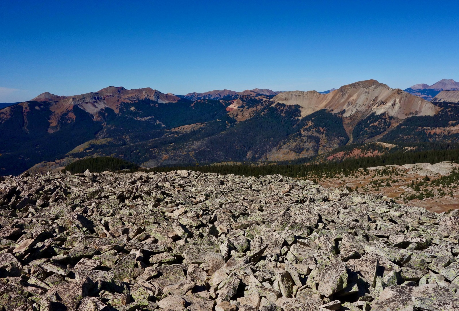
The highpoint of Graysill Mountain is Peak 12,033'. It presents as a small hill on the plateau toward the left in the image below. The Pando Creek drainage is the forested swath bordered on the north by Peak 12,029'. On the skyline is Lizard Head, Grizzly Peak, Vermilion Peak, and Rolling Mountain.

Route: From FSR 579, climb west-northwest while staying well above and north of Pando Creek. Upon reaching the saddle on Graysill Mountain ascend south. Cross the narrow divide to Grayrock Peak. South Point 12,440' is an optional spur. Return to the saddle and climb northeast to Peak 12,029'.

Pando Creek to Graysill Mountain
There is no trail from the road in the vicinity of Pando Creek, elevation 10,400 feet, and there is inevitably a fair amount of confusion about where and how to launch. Following are some options. From the parking pullout, descend northwest on the road. Two streams cross the road in the curve. The first is a tributary of Pando Creek. The imposing rock walls are a warning that this is not the point of access.

This shot of Pando Creek was taken from the pullout. It is at the apex of the curve.

There is a hint of an opening and trail just north of the creek. We started here but, turns out, there was no trail. Instead, the drainage is a steep-walled, tangled mess of deadfall. Do not linger in the creek bottom. At first opportunity, haul up out of creek, climbing very steeply 100 feet onto the north rim of the Pando trough.

Alternatively, continue past Pando on FSR 579 for 0.05 mile and claw up the second tiny draw onto the bench above the creek. That was our descent route and it worked fine.

I have heard that you may also continue on the road past Pando for another 0.15 mile or so. There is rumored to be a pullout. My Forest Service map shows a logging road starting up the hill from here, a presumably gentler route to the bench. There are a bevy of old roads on the lower slopes so find your way back to the creek rim. I intend to return and scope out this alternative in 2020.
The basic idea is to stay well north of the creek and below the south slopes of Peak 12,029' while holding a west-northwest bearing and climbing consistently. We stumbled around a bit and happened upon intermittent segments of trail with very old blazes. Despite our best effort we could not follow the trail all the way to the saddle. At 0.5 mile, 10,920 feet, we walked under a rock glacier flowing from Peak 12,029'.

Walk across the lower end of a talus yard further along. This image features the north face of Grayrock Peak and the east cliffs of Graysill Mountain.

At 0.8 mile we once again happened upon the blazed trail and were able to hang onto it clear to the saddle. If you miss the trail you can still get a pretty good visual on the saddle location.

At about 1.4 miles, emerge from the forest onto the intoxicating immensity of the Graysill Mountain tableland at the saddle, elevation 11,720 feet. It is an exhilarating visual moment that only gets more thrilling throughout the ensuing hike.
Grayrock Peak
The mountain is not apparent at first. Begin walking south in the vicinity of the rim of the Pando bowl. On our way up the mountain we skirted west of a blockfield. On our return we stayed on the rocky rim as indicated on the map above. The tundra is studded with weathered boulders and trees.

If you aren't already on the edge, head southeast and engage the talus at 12,150 feet. The route climbs Point 12,380' (approximated), crosses the narrowest stretch of the divide, and then ascends Grayrock Peak, image-left.

Point 12,380' is a worthy goal by itself because it overlooks both sides of the divide. This image follows the Pando Creek waterway down to the Cascade Creek canyon and up the west slopes of Engineer Mountain.

Swing around to look west over the Hermosa Creek corridor to Whitecap Mountain, and Blackhawk Mountain and Harts Peak, the cluster image-left. Hermosa Peak is southwest of Bolam Pass, image-right.
At its thinnest, the divide is eight to ten feet wide extending for 0.2 mile. Ridge people will marvel as the land just drops away. Passage requires a bit of patience because many of the stone plates are teetering. This landscape is so oversized it is hard to process a mere thread linking two great mountains. Erosion has been ongoing and I am grateful to be here in this moment when humans may cross the bridge to Grayrock, an island mountain.

Near the top of the bridge a social trail skirts to the right of a jumble of unstable rocks on the backbone. The ridge melds into the exceedingly broad, tundra covered, nearly flat backslope of Grayrock Peak.

A large bivouac is located near the rounded crest at 3.2 miles. We searched all about for the peak register that was there in 2014, disappointed that it was gone along with its history. Grayrock is the middle ground between the La Plata and San Juan ranges. See the grand sweep of the Colorado Trail connecting the two.
The total mileage noted above includes the 0.4 mile roundtrip spur to the southernmost point on Grayrock Peak, 12,440 feet. This delightful foray adds just 60 feet of climbing. The South Point looks down on the CDOT maintenance shop at the Cascade Curve on US 550 and up into the Twilights in the West Needle Mountains. Off-image but even closer are the ski runs at Purgatory Resort.

Recross the reef and return to the upcoming route in the saddle at 5.4 miles. I have been chased off this mountain twice by electrical storms. If the weather is good, Peak 12,029' is moments away.

Peak 12,029'
This optional spur long eluded me so I was overjoyed to climb the mellow backslope of the cuesta in 2019. The ascent takes only 20 minutes with just over 300 feet of lift in 0.6 mile. Climb in the sweet spot between the talus and the trees.

There is a large mounded summit cairn and peak register on the crest.

Looking north from this location, the Graysill Mountain plateau segues to Sliderock Ridge and on to Grizzly Peak. Some friends attempted to climb Peak 12,460', the ultra narrow wedge at the south end of Sliderock Ridge. They were summarily booted off the mountain by garbage rock and exposure.

We considered bailing from Peak 12,029' southeast into Pando but it looked unappealing on broken talus. It only took an hour to glide down to the saddle and descend pretty much as we came back to the vehicle.

No comments:
Post a Comment