Travel: From Durango, drive 47 miles to Silverton. Turn northeast and proceed up Greene Street, the main drag, to the north end of town. Zero-out your trip meter as you make a soft right onto CR 2 which is paved for the first couple of miles. Turn right on CR 21 at 1.9 miles. Go to the bottom of the hill and drop a vehicle by the Animas River bridge. At 4.0 miles (not counting the car drop), turn right on CR 4 at the sign for Cunningham Gulch. At the first fork (Old 100 Mine), stay right. Pass the turnoff for Stoney Pass at 5.7 miles. At 7.5 miles, turn right. The dirt surface is good but the grade is steep--4WD recommended. Park on the left at 8.4 miles. Capable vehicles can proceed another 0.5 mile but you pay for it later; the shuttle at the end of the day is already 45 minutes.
Distance and Elevation Gain: 11 miles, 3,700 feet of climbing
Time: 7:00 to 9:00
Difficulty: Trail, off-trail; navigation challenging, carry the maps; mild exposure on the contour trail in upper Arrastra Basin; grave exposure on Hazelton Mountain
Maps: Howardsville; Silverton, Colorado 7.5 Quads
Date Hiked: July 30, 2015
Historical Note: Silverton, Colorado, elevation 9,305 feet, was settled in 1874. It became the hub for outlying gold and silver mining camps. Population peaked at 5,000. The 400 buildings included hotels, banks, 29 saloons, and a red light district on Blair Street. In 1882, the Denver & Rio Grande Railroad operated a train between Silverton and Durango. Now a National Historic Landmark District with a population of 630, Silverton thrives largely because of the renowned Durango & Silverton Narrow Gauge Railroad.
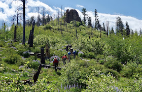
Two hikers descend into Woodchuck Basin. Hazelton Mountain, shown, is on the divide between Woodchuck and Blair Gulch. (Chris Blackshear, photo)
Route: Begin at the Spencer Basin TH in Cunningham Gulch and walk to Blair Gulch. Continue down the road to the confluence of Arrastra Creek and the Animas River. Pass through four high basins, cross four passes, and climb three mountains. The blue-line route is suggested for those who only want to climb Kendall Peak. This option is discussed at the end of the post.
Three principle trails originate in Cunningham Gulch. The trail into Spencer Basin begins as a road on the west side of the gulch. Beginning at 10,800 feet, walk up the road to the stream crossing in 0.1 mile and take a use trail on the right. It rejoins the road at 0.2 mile, having avoided two wades across Mountaineer Creek. The road is hemmed in by black tipped senecio and western chain pod. At 0.5 mile, reach the highest parking area. The road transitions to a trail paralleling high above the creek. Point 13,434', climbed from its north or south ridge, heads the basin.
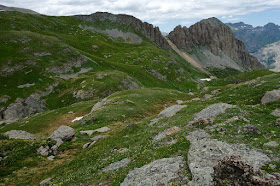
Reach the lower basin in 1.4 miles. The trail steepens until it flattens in upper Spencer, elevation 12,400 feet, at 2 miles. Locate Pass 12,900', shown, east of Pt 13,409'. Traveling north, cross Mountaineer Creek. Fields of alpine avens, marsh marigolds, and pink bluebells send me into reverie and gratefulness.
Pass 12,900' is a straightforward climb, gained at 2.6 miles. Straddling Spencer Basin and Arrastra Basin, these hikers contemplate Kendall Peak.
From the pass, locate Pass 12,920', the low point between Kendall Peak and Peak 13,409'. This second pass is on the divide between Arrastra Basin and Deer Park. A word of caution. The half mile-long contour trail has deteriorated since I was last there in 2010. It is a little edgy. In four or more places the trail platform is gone. Ball bearings cover resistant soil. There is mild exposure on this traverse.
The image below looks back on friends crossing the contour trail.
Reach Pass 12,920' at 3.1 miles. It is one mile round trip to Kendall Peak. This is the highpoint of the day and the highest pleasure. Don't skip it.
Kendall Peak ridge presents in three segments, all of them just narrow enough to feel like a ridge. The walking is Class 2 and exposure is minimal.
In the image below, friends are utilizing the off-ridge trail while climbing the summit block. But why get off the ridge when you can comfortably and happily stay on it?
A selection of Colorado's highest peaks circle the summit. Nearby to the west is Kendall Mountain, image-left. Woodchuck Basin, which this hike spans, is to the north. Hazelton Mountain, perhaps the most enthralling part of the day's journey is further north, center-right in this image.
As for Kendall Peak's northeast ridge, I have been to Point 13,289' from Silver Lake, shown. While I did not continue to the summit, my hiking partner succeeded.
Looking south, Arrow and Vestal steal the show as is their habit. Return to Pass 12,920' at 4.2 miles. (THW, photo)
Drop east to an old mining track in Arrastra Basin at 12,800 feet. Follow it north to the Iowa Mine at 5.0 miles. Historic artifacts litter the area. Please leave them in place. A grate covers a mine shaft that drops to oblivion. The mine is hung on a hillside 600 feet above the Silver Lake ghost town, elevation 12,186 feet.
Little Giant Peak and King Solomon Mountain preside east of Silver Lake and Arrastra Basin. (THW, photo)
Hold the contour to Pass 12,800' at 5.4 miles. This pass is between Arrastra and Woodchuck basins.
Round Mountain, 12,912', is on the broad ridge heading north from the pass. Walking on the taper to the highpoint is welcoming and only 0.4 mile roundtrip. While Round is not a legal summit, do not ignore this glorious, sensational traipse.
Take the mining track west, dropping off the pass into Woodchuck Basin. The rock is broken and we were lured into staying on the old road too long. Once 200 feet below the pass, just go down green ramps to the drainage at 12,160 feet. Pass 12,520' is image-left; Hazelton Mountain is shown at right.
Climb pitched columbine-covered slopes to the final pass at 12,520 feet, 7.0 miles.
Along the way flower communities take turns vying for attention. Here lousewort and rosy paintbrush take over.
If you are not climbing Hazelton Mountain, take the pack trail down into Blair Gulch. Hazelton is 0.5 mile north on the ridge. Go up and over a small, subsidiary peak. Drop to the low point at roughly 12,300 feet. Then climb the first ultra steep green chute. Looking at the image below, the correct slot is the most southerly.
Once on the rock, stay on the short knife edges as close to the east-side towers and chutes as you dare. Drop-offs on the east are vertical but the rock is more solid at the edge. The west slope is too pitched for self-arrest; venture out on it only when necessary. The mountain is covered in loose, small, grey stone. A caveat: some of my friends shrugged off the exposure as mild; for others, it worked the limits of their composure. (THW, photo)
The summit, by contrast, is altogether friendly. Walk to the abrupt north end for a view of the triangular face across the ridge breech. (THW, photo)
Return to the bottom of the green chute and drop 200 feet to the trail in Blair Gulch. Flowers are outrageous, the bluebells head high.
At the head of the deep gorge at 11,600 feet, the trail veers right and encounters a talus slope. Apparently the trail crosses the slope. We soon lost it and so we picked our laborious way almost 400 feet down the talus field.
The Blair Gulch pitch mellows. Follow along the stream to meet up with trail once again at 10,800 feet. The track goes into the woods and comes to a private home, Dana Lode, at 9.0 miles. The land owners graciously allow the passage of hikers. Go around their green gate. Turn right on "Blair Gulch Road," CR 20A. It is possible to drive to this point for the vehicle drop, thereby avoiding the steep descent. A friend said, "The walk down the road is a bad ending." It does have some great mining relics.
Upon intersecting the road out of Arrastra Basin, turn left and in 0.3 mile arrive at the confluence of Arrastra Creek and the Animas River, elevation 9,500.
Thank you, Dan, for sharing this route with me.
Blue-Line Route, Deer Park to Kendall Peak: I did this climb in October of 2008. It was 16 degrees at the trailhead and 10 degrees and blowing hard on the snow-covered mountain. From the Deer Park TH at 11,600', locate the pack trail that goes northwest, curving under the west ridge of Pt. 13,399'. Take this trail to Pass 12,920'. Climb the peak. To create a loop, return to 13,100 feet and descend the volcanic west ridge that straddles Kendall Gulch and Deer Park. My notes suggest it is dramatic with exciting drops. Be a purist and go over Pt. 12,730'. Upon reaching Pt. 12,210', plunge south to the road, then east to the trailhead. The loop is about 5 miles with 2,400 feet of vertical. While you are up there, from Pass 12,920', you can climb Pt. 13,409' via the northwest ridge. The south ridge is a delightful knife edge.


