Travel: In Silverton, drive up Greene Street, the main drag, to the north end of town. Make a soft right onto CR 2 and measure distance from there. It is paved for the first couple of miles. Turn right into Cunningham Gulch at 4.1 miles. The road to the Old Hundred Mine goes left at 4.3 miles; stay right. Pass mining debris and picturesque ruins. At 5.9 miles, stay right as the track to Stony Pass veers left. There is a large camping area with an outhouse at 7.5 miles. At 7.7 miles, the left spur dead ends so stay right. The road crosses Cunningham Creek and begins climbing the west wall making a big switchback. The track deteriorates and steepens. At 8.6 miles the left spur goes down to the Highland Mary Trailhead. Take the right fork and look immediately for a large parking platform on the left at 10,800 feet. 4WD is preferable but 2WD with good clearance and sturdy tires should suffice. Please see the October 11, 2024 comment for a road update--2WD probably won't get you to the platform.
Distance and Elevation Gain: 12.7 mile loop; 4,100 feet of vertical. The alternative return via Highland Mary Lakes is 10.3 miles.
Time: 6:30 to 8:30
Difficulty: Trail, off-trail; navigation challenging; Class 2 with no exposure; Class 2+ with mild exposure on optional Point 13,409'
Maps: Howardsville; Storm King Peak, Colorado 7.5 USGS Quads
Latest Date Hiked: August 14, 2024
Quote: Geometry is one and eternal, a reflection of the mind of God. Johannes Kepler, 1571-1630
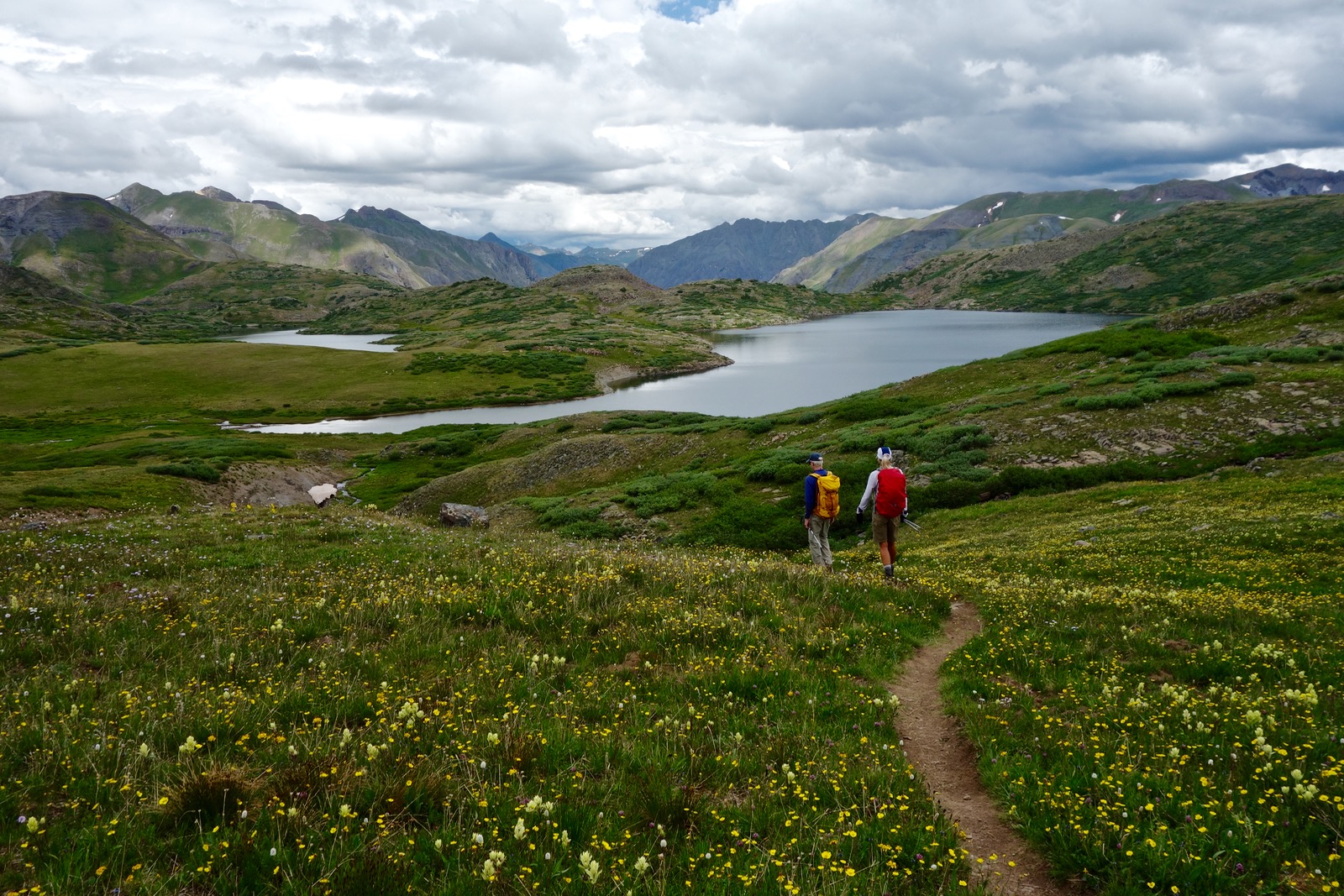
The visual splendor of the Grenadier Range rewards hikers as they traverse from Mountaineer Peak to Mount Rhoda.

Route: From the trailhead in Cunningham Gulch, elevation 10,800 feet, bear west on an established trail into Spencer Basin. Gain "Rhoda Ridge" between Mountaineer Peak and Point 13,409'. Walk south on the ridge while climbing five prominences spanning Point 13,409' and Whitehead Peak. From the Whitehead/Rhoda saddle, walk east to the trail near the highest lake in the Highland Mary chain. Walk southeast to Verde Lakes. Locate trail #674 and go east to intersect the Continental Divide Trail. Travel north-northwest, returning to the Highland Mary Trailhead. Ford Cunningham Creek to close the loop. This is a fabulous loop assuming you find it. The two places that require navigation skills are descending from Rhoda Ridge, and finding trail #674. Many trails on the old topos no longer exist.
The big loop described is the black-line route. The blue-line route is the shorter Highland Mary Lakes option, and the red-dot route is the shortcut from Verde Lake to #674. Click on the map to enlarge.

Three principle trails originate in Cunningham Gulch. The trail into Spencer Basin begins as a road on the west side of the drainage. From the parking area, walk up the road to the stream crossing at 0.1 mile and take a social trail on the right. It rejoins the road at 0.2 mile, having avoided two wades across Mountaineer Creek. (2024 note: The social trail is overgrown. Stay on the road.) The image below shows the road rising from the trailhead and one of the Mountaineer Creek cascades. (THW, photo)

The road is hemmed in by black tipped senecio and western chain pod. The track served mines and evidence is plentiful. Please note that images posted here were gathered from many trips in different seasons over the past 20 years.

At 0.6 mile, reach the highest parking area at 11,240 feet, shown. If you intend to restrict your hike to the Spencer Basin region, park here. (In 2024, the access road was washed out and rutted--dedicated 4WD only.) The road transitions to a trail (signed Spencer Basin) paralleling high above the creek. Sugarloaf, 12,754 feet, is image-center.

The landscape rises in a series of benches. The first reprieve is in one mile at 11,600 feet. Elk were bedded down beside the trail in autumn, their lingering scent musky, green, and sharp. Peak 13,434' heads the basin. Unofficially named Mountaineer Peak, this hike goes over both summit knobs.

Reach the lower basin in 1.4 miles and cross Mountaineer Creek at 12,040 feet. Walk amongst an exuberant assemblage of hybridized paintbrush. Color combinations are delicate and intricate. Below, capped Mount Rhoda is image-right and its east ridge splays across the basin.

At 1.8 miles, 12,220 feet, pass the cairned turnoff for Sugarloaf. In 1.9 miles at 12,400 feet, come to a platform in the upper basin from which you can see the saddle between Mountaineer Peak and Point 13,409'. In autumn, the sense of peacefulness is pervasive. Plants softly sigh after a furious level of summer activity. Below, Mount Rhoda is left, Mountaineer Peak, center, and Point 13,409', right. (THW, photo)

Typically, we've followed the dwindling track as it descends slightly into a marshy catch basin. It works better to stay on the contour until directly east of the saddle. I've approached the saddle from both sides of the ravine. The slope is steep but turf ledges assist. Ideally, when the saddle is free of snow, it is best to top out to the right of the center hump, seen below. That positions you properly for Point 13,409'.

At 2.7 miles, reach the saddle at 13,340 feet. There is but one legal summit on this hike, Mountaineer Peak. However, the four additional prominences have unique, compelling features. The first is Point 13,409', informally named Spencer Peak (LiDAR 13,424', rise 148 feet). This optional out-and-back takes just 20 minutes. Go north on a narrow ridge with excellent scrambling rock.

The summit ridge thins to a mild knife on the short traverse to the northern highpoint. (THW, photo)

From the crest, look directly down into Arrastra Basin. Little Giant Peak is east of Silver Lake. Kendall Peak is an extension of this ridge, off image-left. (THW, photo)

The image below was shot looking back from the north end of Point 13,409'. Point 13,399' tops the west ridge on the right. Return to the saddle, climb the minor knoll and then walk west to this intimate prominence at 3.3 miles. It features a view down into Deer Park which is rimmed on three sides by Rhoda Ridge. Point 13,399' is the highpoint along the northern perimeter.

Rhoda Ridge is notable for its simplicity and ease of passage. The Grenadier Range is quite the opposite. I think of the peaks as "mathematical geniuses." But I suppose it is more sensible to embrace the notion that they were created by an earthly force with a proclivity for the geometric golden mean. From the left: the Trinity Peaks, Vestal Peak's Wham Ridge, Arrow Peak, and in the background on the right, Turret Peak and Pigeon Peak.

Walk south on the ridge to Mountaineer Peak. It is an unobstructed, simple, mostly grassy climb to the north knob. The mountain rolls off west into Deer Park. Near vertical cliffs and couloirs define the east edge as you approach the summit.

Peak 13,434' is a legal summit and the highest point on the divide between Deer Park and Spencer Basin (LiDAR 13,441', rise 503 feet). The companion hike to this loop is the Deer Park circuit which visits seven prominences. The climb begins from Deer Park and rotates clockwise from Point 13,399' to Point 12,829'. Exit from the southwest end of the ridge to Point 12,462' and take the Whitehead Trail back into Deer Park. There are several ways to get started from Deer Park. Once I climbed straight up the gully on the south face of Point 13,399'. Another time, I took the pack trail to the Kendall Peak/Point 13,409' saddle and then a contour trail across the north face of Point 13,409'. I have friends who have climbed from the Kendall Peak saddle up the northwest ridge of Point 13,409'.
In autumn, tundra rolls off from Mountaineer Peak in a pleasing, monochromatic tan. Sharpen your focus and color splashes are unnaturally brilliant: lime green, gold, red and orange. (THW, photo)

The south side of Peak 13,434' is scrabbly to the saddle at 13,121 feet (LiDAR). Mount Rhoda is distinguished by its flat cap rock, easily identified from Molas Pass.

The 20 foot summit scramble straight up the north end is on excellent rock. You can take it any number of ways. I use the stairstep just west of center, shown. This pitch can be avoided by going around to the west for a walk-up.

Crest Mount Rhoda (map 13,402') at 4.5 miles (LiDAR 13,418', rise 297 feet). From this glorious, flat-topped domain scope out the route east to Verde Lakes. In the image below, two of the Highland Mary Lakes are left of center. The small lake where we'll pick up a trail is right of center. Verde Lake is to its right.

The fifth and final ridge prominence is Whitehead Peak, seen here from the summit of Mount Rhoda. Rising only 139 feet from the saddle, it is not a legal summit but there is a unique reason for visiting.

Descend south to the Rhoda--Whitehead pass. According to the topo, the Deer Park Trail once crossed here but I have searched on both sides of the pass and the trail is no more. Crest Whitehead Peak, 13,259' (LiDAR 13,276', rise 139 feet), at 5.0 miles. From this broad, welcoming height the view of the Grenadier Range is spectacular. We are separated only by the Elk Creek trench which carries the Colorado Trail.

Leave the ridge and launch into the second segment of the hike across a continuous flow of universal tundra. The next objective is the highest of the Highland Mary Lakes at 12,620 feet. This lake is located south of Point 12,655'. Either return to the Whitehead/Rhoda pass or simply walk down the tundra ramp northeast from Whitehead Peak. Once you are directly east of the saddle hold an east-southeast bearing, staying perpendicular to Rhoda Ridge, as indicated below. It would be easy to get lost because vision is restricted from one dale to the next. In the summer, king's and queen's crown is abundant.

Intersect the trail about 0.8 mile from the ridge. Horse traffic is evident. Turn right and shortly reach the exquisite lakelet. Cross the outlet on the trail at 6.3 miles. In the image below, you can see the trail going up a slope on the other side of the lake.

Soon after the crossing the trail disappears momentarily. It reappears in a depression all the while heading southeast toward Verde Lakes. Distinguish the treadway from endless sheep trails. Verde Lake is image-left. The path passes two landmark boulders and stays west of another Highland Mary Lake at 6.7 miles. Years ago there was a rare Colorado tansy aster growing in this area, plus snowlover, daffodil senecio and Coulter's erigeron.

White Dome glistens appropriately while rosy and sulfur paintbrush thrive in wetlands just west of Verde Lakes.

In 7.1 miles, the trail passes by west Verde Lake on the north. The lake is characterized by stone ledges along the western shoreline. Fishing is good. In autumn, communities of bottle gentian crowd the trail. (THW, photo)

Upon reaching the east lake, the trail curves north and climbs to a minor pass between the Verde and Highland Mary lake basins, just to the left of this image. Our next objective, trail #674, leaves from the head of the lake and climbs to the low point between the two rounded knolls, shown.

All routes back to the trailhead go up the draw to the north. The tracks diverge after crossing a small stream. If you wish to shave off 2.4 miles, take the blue-line route noted on my map. Simply head north to popular Highland Mary Lakes. Navigation is easy on trampled trail all the way and the hike is spectacular. My favorite part is threading on rock runners between the lakes.
For those doing the big loop, finding #674 is the next navigation challenge. There are a lot of trails with different names in this area, many marked poorly if at all. Note the red-dot route on my map. This route goes east from the aforementioned stream crossing and joins #674. You can take this shortcut route even if the trail is intermittent provided you are good with a map.
For the standard route, from the stream crossing, notice a trail going south toward the shore of east Verde Lake. Follow it around to the head of the lake where there are campfire rings. Scrounge around for #674 here. No cairns mark the route but the trail becomes apparent and carries horse traffic. It goes up the east ridge from the lake. Concentrate to stay on track.
Caution: Do not inadvertently keep going past the lake on the perimeter trail. This is the Whitehead Trail marked on the topo. You will soon be plunging into the wrong world, away from your trailhead.
The image below was taken from trail #674. Mount Rhoda is in the distance. The Highland Mary Trail goes off to the right/north of Verde Lake. (THW, photo)

The shortcut trail joins #674 at 8.1 miles and the well-established track bears east to an overlook at 8.6 miles and turns northeast. The prominent gulch below runs down into Elk Creek. Trail #674 drops roughly a hundred feet to cross the drainage at 8.9 miles, 12,320 feet. Vertical black volcanic walls are on the east side and a talus field on the west.

Marked with posts, the trail climbs gently northeast. We see a stone boy, characteristic of cairns on the Continental Divide Trail, #813. The tracks parallel each other for a time and merge at 9.4 miles, 12,560 feet, the terminus of #674. A golden eagle with a white tail patch probed the ground and we passed a couple of backpackers on the Colorado Trail which shares the route in this area with the CDT. Traveling north, Canby Mountain, 13,478', is image-center.

The Colorado Trail and CDT make a sharp turn to the right toward Stony Pass while our unmarked trail continues straight ahead.

Cruise lazily downhill through the tundra. Two white sheep dogs put up a fuss to divert us from their flocks. I meet them every time I walk through this area. Reach the tipping point at 11.1 miles, 12,050 feet. Sugarloaf is suspended above Spencer Basin and our morning peaks look far away. Plunge down into the sidewall of Cunningham Gulch on a pleasant but steep trail through a rapidly dying forest.

Two junctions await. At 11,380 feet, 11.9 miles, go left toward the Highland Mary Trailhead. The Cunningham Gulch option will take you back on a longer path. Upon reaching the Highland Mary Trail at 12.2 miles, turn right. In another 0.3 mile pass trailhead parking for Highland Mary. Continue down the road and ford Cunningham Creek. Find a shortcut trail on the left that closes the loop.
Sugarloaf, 12,754'
Sugarloaf is an ideal destination for trail hikers who wish to explore Spencer Basin and climb to a stellar vista atop a small mountain. Roundtrip to the unranked summit (LiDAR 12,757', rise 188 feet) is 6.0 miles with 2,000 feet of vertical. From parking at 10,800 feet, walk 0.6 mile up the track to the signed Spencer Basin Trailhead at 11,240 feet.

Bear southwest on the single track, open to hikers, mountain bikers, and equestrians. At 1.8 miles, 12,220 feet, watch for a cairn marking a spur trail heading southeast. You will get a visual of your destination (image-left) and the saddle you must acquire. My first trip to Sugarloaf was in 2012 and the trail has since been trenched from use--you can't get lost!

Step over a pristine, crystal-clear tributary of Mountaineer Creek. The basin tends to be rather boggy and squishy. Be as gentle as you can in this sensitive area.

The trail ascends moderately. It actually skirts the saddle and climbs further than necessary. So when you judge yourself to be under the low point on the ridge, leave the track and make a dash for the saddle at 12,569 feet. Locate a social trail mounting the southwest ridge of Sugarloaf clear to the summit. The first little bit is on a somewhat scrabbly thin ridge composed of volcanic rock. It's Class 2, very fun, and will make you feel like you are climbing a mountain. But do pay attention.

The mountain expands to a broad, grassy crest. Sugarloaf is on the divide between Spencer Basin and Highland Mary Lakes. There are broad-spectrum views into the lake basin, east to the Continental Divide, and south to the Grenadiers. Simply reverse course to return to the trailhead.

This is an image of Sugarloaf shot from Mount Rhoda. It gives you a nice perspective on the structure of the mountain in the context of its surroundings--rolling hills stepping down to the west from the Continental Divide. (THW, photo)

8 comments:
Hi Debra! Thanks for all your great trip reports. There isn't too much info available for the less-traveled hikes in the San Juans and your reports are always so helpful. I have a question about Mount Rhoda. Is there still an 8-foot cairn on the summit?
Thanks so much!
- Katie
Hi Katie, I am delighted you find these little descriptions helpful. My greater mission is to document the American West but if I can be useful while I'm at it, all the better. Alas, the Stone Boy on Rhoda is gone. There's just a little pile of rocks and a peak register. Debra
That was one of the few remaining cairns built by Hayden Survey members (including Franklin Rhoda) in 1874. Would have been neat to see it. Thanks for the info!
Hey Debra, Its dave craft (wimberosa at gmail). Blogger sign-in seems to be having trouble. Anyhoo....never been to spencer basin so looking at google earth in combo with your description makes me think I should be able to easily cross back over from the lower tundra below whitehead (after mountaineer and rhoda ridge crossing) back into spencer basin near the saddle before sugar loaf. That would put me at 7 miles and a nice circuit of these peaks. Seems like you've done this basin a lot. Plausible? Been banging them out myself so far this summer. Trying to get 2 a week. Gotta bag niagara and grizzly shortly. I see you're doing some san rafael swell hikes as well. 3 trips so far this year for me... that place is the shizzle.
The answer is YES. That trail that you took over to verde has a spur off it that goes right to the upper saddle between rhoda east ridge and sugar loaf. Absolutely stunner of a day. The flowers at the back upper shelf below the couloir heading to the saddle north of mountaineer were amazing. Saw absolutely no one in spencer basin. Saw two hikers top out on rhoda while I was on mountaineer. Spencer is definitely a candidate for most beautiful basin in the san juans.
Dave
Dave, Thanks for posting this new trail option on Earthline. I look forward to checking it out. The flowers and the mountains worked their magic and you brought tundra euphoria home with you. So pleased. Debra
Hey Debra! Thanks for signing our book! The road from Cunningham campsite to the 10800 platform is most likely impassible to 2WD from the rain, I have a lifted Subaru and needed 2 goes! Just an update, cheers!
Super important travel information. Thank you for keeping Earthline fresh. It takes a community...
Post a Comment