Point 5,821' and Peak 5,932' are a study in opposites. The rounded,
welcoming point is an easy walkup to a summit that goes on forever. The
well-armored, sheer-faced peak permits one safe path to its airy apex.
Walk east out of the large parking area, elevation 5,760 feet, on a
continuation of the Old Sheffield Road. There is likely to be a lot of
footprints in the sand but they soon dwindle and solitude will be
your companion for the remainder of the day. A friend calls this initial sand slog the Big Hurt and you may agree while trudging uphill at the end of the
hike. Piñon and both Utah and Rock Mountain juniper have managed to take
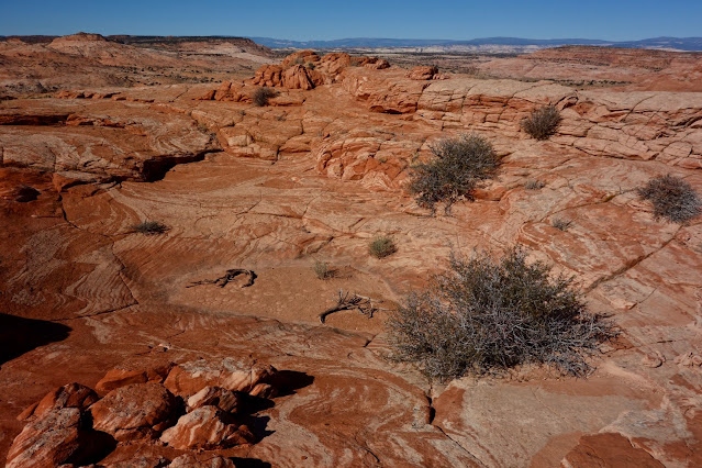
hold on the sand plain. The ubiquitous sand sagebrush, shown, prefers deep sandy soil habitats found
on the Colorado Plateau, including Southern Utah.

In morning light our two primary peaks will appear as silhouettes; they are
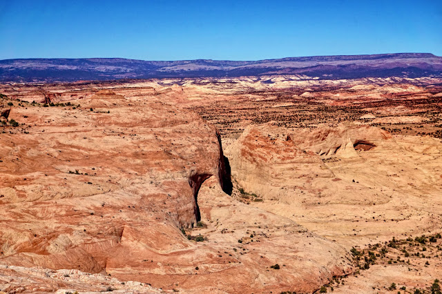
visible on and off as you approach. Looking at this image shot in the
afternoon, the route tracks south of incised Spencer Canyon framed by
deeply fractured, massive sandstone formations, image-left. The route curves southeast
and tracks under the flat-topped mesa, Peak 5,981', and then enters the
grotto between the two prominences, image-right.
For strong adventurers, you could reasonably visit the
Spencer Canyon Grid
either going or coming. It is a rare opportunity to study a right-angled
world with forks bisecting the main canyon on its way to the Escalante River.
Cross into the Wilderness Study Area at 0.8 mile. In 1.3 miles, transition
from the track onto a polygonal sandstone slab at the head of "Ponderosa
Pine Valley." The numerous grand, old growth trees are thriving along a
survival thread where they are moistened by occasional waters in the wash and slickrock runoff. (Thomas Holt Ward, photo)
Hold your eastward bearing while crossing a series of drainages, typically
dry. "Super Tanker Wash" has been a reliable source for clear water in
years past but in 2020 it was bone dry as the Southwest suffers under a
pitiless drought. Cross between the tanks on a stone rib. A tenth of a
mile further, cross a south fork of Spencer. It emanates from the escarpment of Red
Breaks near Point 6,015'. Walk downstream to see the watercourse plunge into the Spencer Canyon abyss. (THW, photo)
Moqui marbles, spherical iron oxide concretions, have rolled into sandstone cracks and spill out onto the surrounding platform. Black jewels cast long shadows in morning light.
At 2.6 miles, turn 90 degrees to the south to skirt a small dome,
image-center. Over the next 1.5 miles bear essentially southeast
passing below a series of prominences, including the south
ridge of Peak 5,981'. This is free-range rambling and you will
inevitably cross fields of sand. But the closer you are to the
formations, the better. Search out sandstone runners.
Make the most of a two-foot-wide sidewalk that curves around and
heads a drainage.
Sandy patches hold clumps of ready-to-harvest Indian ricegrass in the fall
and wildflowers in springtime. (THW, photo)
Sandstone flares from domes onto the benchland in a swirling and oozing blend of cream and terra cotta, colors predominate throughout the region. (THW, photo)
Crawl under a barbed wire fence at 3.7 miles. (THW, photo)
Three tenths of a mile past the fence you will round the south ridge of
Peak 5,981' and see the two contrasting peaks. Descend into a south tributary of the Escalante River, at 4.1
miles. It trenches up further downstream. Walk east around the base of
Point 5,821', shown.
Grotto
We'd spotted this hollow four years prior and resolved to return to see if we could ferret a way in. We anticipated a small enclosure but it turned out to be a large edifice. At 4.5 miles, head south up a relaxed pitch into
the grotto. Note, the circumnavigation loop begins at the start of this
ascent. With all of our probes it was a 4.4 mile loop for a total of 13.4
miles. Your mileage will vary. (THW, photo)
The flat-floored grotto is bifurcated by a ridge trending north from the headwall creating a lower and upper chamber. The subtle hue of piñon and juniper is offset by the bright green leaves of manzanita and golden grasses. The walls of the lower chamber are smooth blank canvases with shallow alcoves. There was no sign of human presence as we walked into the confined and intimate enclosure. (THW, photo)
The flat western face of Peak 5,932' loomed 350 feet overhead as we walked into the squeeze at the back of the chamber. Soon it was a packs-off slot with rippled walls. We were pinched out near the headwall. (THW, photo)
A massive alcove hollows out the entrance to the equally beautiful higher chamber. (THW, photo)
The crack was every bit as compelling as the first. In just a few minutes we were looking down on this slot from Point 5,821'.
Point 5,821'
Climbing Point 5,821' is easily done on the north slope. This image depicts the grotto and Peak 5,932'
from the start of the climb. (THW, photo)
Wander over the face of the slope looking for the shallowest pitch. There are plenty of features that make this climb quite safe and fun.
The surface of the summit ridge is wondrous with outcrops and tanks evolving into weathering pits.
The rounded sandstone crest is complicated and possesses a couple of highpoint candidates. The first is the tallest but at the time we weren't sure so we climbed the knob to the south just in case, shown.
Peak 5,932'
We had no idea whether we could successfully climb the triangular peak and we figured it out on the fly. What follows is a description of our route. I got up there without scaring myself, a key consideration. First, we contemplated crossing the upper chamber headwall, shown. The bridge looked too exposed and we discarded the idea. That proved to be a good decision because the knife ridge ends at a dangerously steep slickrock slide.
We descended southeast on a shallow slope a good distance and crossed a ravine, shown, emanating from the south side of the grotto headwall. It was a pleasure walking on sandstone biscuits.
The south ridge was armored so we started circling. We worked our way up the southeast face using a series
of narrow benches. As is often the case with Navajo Sandstone what looks at a distance like a formidable wall turns out to be a slope textured with safety ledges.
We were fortunate to happen upon a river of black-plate concretions.
We wandered hither and yon finding a path upward. There were some steep friction pitches but they were protected with ledges. We discovered a comfortably wide platform at the base of the summit block at 5,820 feet. Looking at the image below, it is located where the color changes from beige to brick.
We walked north searching the block looking for access. From the platform we could look into the "Milagro Passage." We discovered this corridor on the Spencer Canyon Grid and Ladder Canyon hike. The 50-foot-wide hallway is constrained by towering and sheer carmine walls. (THW, photo)
We'd almost circled to the west face drop when we got lucky and found a plausible route to the crest. We mounted the block at a crack on the north face, image-center. It is a fairly steep friction pitch. The zenith is the tan-colored stone on the skyline.
We were elated and grateful to arrive on the apex, all the more spectacular by its tiny dimension. This image looks west across the gulping gap of the grotto to Point 5,821'. (THW, photo)
Nearby to the east is the Escalante River canyon with the Henry Mountains in the way beyond. On the Red Breaks topographical map, Point 5,543' and its subsidiary look inconsequential and we'd given thought to climbing them, image-left. But from here, they did not look casual and we left them in solitude.
Point 5,575'
Mounting this point on a low ridge was unintentional. It turned out to be our way back to the trailhead. First, we down climbed back onto the platform. From there we descended to the rock outcrop, shown, and then dropped another 100 feet. The idea was to descend the north face but it rolled off and we could never get a visual all the way to the bottom. We retreated back up to the platform and
retraced our steps to elevation 5,700 feet.
At that point we thought it'd be fun to circumnavigate the cluster looking for alternative routes up the peak. We explored the east side of the mountain rich with cracks, alcoves, weathering pits, and dry tanks. We got cliffed out so we thought we'd go through the crack between Peak 5,932' and Point 5,575'. It was pinched at the south end so after fruitlessly hunting around for a way down in, we wandered up Point 5,575' hoping for no further obstacles. Sure enough, it was a gentle pitch down from there. We headed west and closed the loop.
This final image was shot from Point 5,575' toward the east face of Peak 5,932'. From here, it appears that skilled climbers may be able to mount the north face. Given the sublime nature of this route, I wouldn't trade away even one footstep for the sake of a more efficient climb.
An important note from author Steve Allen about protecting endangered National Monuments in Southern Utah.


