Essence: These two remote peaks may be climbed reasonably in one day from separate start points. The drive is a commitment so plan to combine them while you are in there. Located just south of the Gila River, Grayback is composed of weathered intrusive igneous granite and South Butte is volcanic. They each have fascinating features typical of their rock composition and navigation challenges. Cairns are nonexistent on Grayback and sparse on South Butte. Class 3 scrambling and exposure can be avoided. The views north across the Gila River and into the White Canyon Wilderness are superlative. We climbed Grayback first and the descriptions below reflect that. The hikes are on public land administered by the Bureau of Land Management.
Travel: Both hikes are accessed from the Florence-Kelvin Highway. In Florence (AZ 79), turn east on Butte Avenue and measure distance from there. It soon transitions to the Florence-Kelvin Highway. Upon leaving the pavement, 4WD with high clearance is required for both hikes. At 14.3 miles cross a very wide wash on a cement casement. (The left turn on Cochran Road to South Butte at The Boulders is at mile marker 15.6). For Grayback continue on the highway. The road turns to wide, graded dirt at mile marker 18.8. Pass under transmission lines and swing north at mile marker 22.0. Turn left at mile marker 23.1 and reset your odometer. Turn left at 0.6 mile and drive over a cattle guard. The track is prone to big ruts and potholes. At the Tea Cup Substation, 1.4 miles, there is a chaotic intersection and two gates, one locked. Open and close the barbed wire gate and turn right. The road bears northwest and further deteriorates. At 1.8 miles stay straight at a right branch. (Take this road if you want to approach Grayback from the east.) Pass a windmill with only the rudder in place (on topo). Park at 3.85 on the right just past a band of boulders. Allow one hour from Florence. Your mileage will likely vary. For South Butte, return to the Florence-Kelvin Highway and go west. Pass the locked gate for The Boulders and turn right at mile marker 15.6. Measure distance from there. Pass a large parking lot for OHVs. The road branches--stay on the main track. At 5.7 miles turn left into Donnelly Wash. Your vehicle must be capable of driving through six inches of sand. Park off to either side of the wash at 9.1 miles.
Travel: Both hikes are accessed from the Florence-Kelvin Highway. In Florence (AZ 79), turn east on Butte Avenue and measure distance from there. It soon transitions to the Florence-Kelvin Highway. Upon leaving the pavement, 4WD with high clearance is required for both hikes. At 14.3 miles cross a very wide wash on a cement casement. (The left turn on Cochran Road to South Butte at The Boulders is at mile marker 15.6). For Grayback continue on the highway. The road turns to wide, graded dirt at mile marker 18.8. Pass under transmission lines and swing north at mile marker 22.0. Turn left at mile marker 23.1 and reset your odometer. Turn left at 0.6 mile and drive over a cattle guard. The track is prone to big ruts and potholes. At the Tea Cup Substation, 1.4 miles, there is a chaotic intersection and two gates, one locked. Open and close the barbed wire gate and turn right. The road bears northwest and further deteriorates. At 1.8 miles stay straight at a right branch. (Take this road if you want to approach Grayback from the east.) Pass a windmill with only the rudder in place (on topo). Park at 3.85 on the right just past a band of boulders. Allow one hour from Florence. Your mileage will likely vary. For South Butte, return to the Florence-Kelvin Highway and go west. Pass the locked gate for The Boulders and turn right at mile marker 15.6. Measure distance from there. Pass a large parking lot for OHVs. The road branches--stay on the main track. At 5.7 miles turn left into Donnelly Wash. Your vehicle must be capable of driving through six inches of sand. Park off to either side of the wash at 9.1 miles.
Distance and Elevation Gain: Grayback, 2.0 miles, 1,100 feet; South Butte, 2.4 miles, 1,200 feet
Total Time: 2:30 to 3:30 each
Difficulty: Off-trail; navigation challenging; Class 2+ with mild exposure (Plenty of Class 3 and cliffs if you go looking for it.); brushy, wear long pants; hike in winter months and carry all the water you will need.
Maps: Grayback (for Grayback), North Butte (for South Butte) AZ 7.5' USGS Quads
Date Hiked: March 22, 2024
Quote: The colours of things rise up from the roots of the earth. Paul Cézanne
The Gila River flows from its headwaters in New Mexico clear across the state of Arizona to its confluence with the Colorado River in Yuma. As seen from Grayback, under an azure sky the river wends lazily between South Butte and North Butte. (Thomas Holt Ward, photo)

Grayback, 3,570'
There are multiple approaches to the isolated Grayback summit. The route described below is designed to maximize exposure to the extraordinary weathered granite structures found on the southern slopes of the mountain.

Route: Hike northeast to the southeast ridge of Grayback. We left the ridge to bypass a major outcrop. For a Class 2+ finish, return to the southeast ridge and ascend to the summit ridge (black-line route). The blue-line route explores the granite shelf on the south side of the mountain and concludes with a Class 3 scramble on the summit ridge. Note: The Grayback quad has 20-foot contour intervals.

We determined the best parking location on our return. Originally, we parked 0.05 mile sooner and started up an old two-track. We soon were trapped in a mumble jumble boulder squeeze. We backed up and clambered up and over a bank of boulders. The image below was shot from the preferred parking area just beyond the row of boulders at elevation 2,520 feet.


Walk on crushed granite, weaving between boulders and cactus. We were intrigued by black basalt boulders of volcanic origin scattered on the surface. The mountain is primarily composed of crystalline granite. We passed by a dike made from the more typical stone. (THW, photo)

The landscape was awash in typical Sonoran flora--ocotillo, saguaro, barrel cactus, silver cholla, pricklypear, mammillaria, and paloverde. We saw a profuse display of
over-sized, pure white desert chicory blossoms. Most notable was the blooming desert chia, shown. The intoxicating smell of mint was so pervasive it was almost too intense.
(THW, photo)

Purple flowers were featured on our hike--lupine, scorpion weed, and prairie spiderwort, shown. (THW, photo)

The steep climb up the roller is ball bearing slick. (THW, photo)

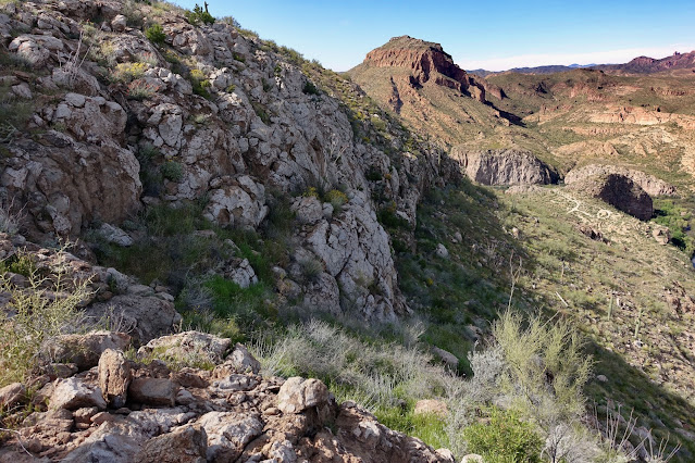
Gain the southeast ridge at 3,130 feet, 0.6 mile. It is a concentrated landscape on this side of the mountain with several approach choices. Looking at the image below, the easier of our two routes mounts the ridgeline on image-right. We bypassed the outcrop midway up the ridge. The more difficult route leaves the ridge and works over to the granite shelf, image-left. It then cuts back up to the summit ridge, hitting it to the right of the stone tines depicted. (THW, photo) 
At 3,220 feet we were up against the formidable outcrop. We bypassed on the left which worked fine. If I had it to do over, I'd see if I could scramble on or close to the ridgeline.
At 3,220 feet we were up against the formidable outcrop. We bypassed on the left which worked fine. If I had it to do over, I'd see if I could scramble on or close to the ridgeline.

On our bypass we walked past a slab with solution cavities covering its south face. The most outstanding and memorable feature of this hike were the massive and flowing weathered granite boulders.

At 3,320 feet the routes split. For the easiest route to the summit, return to the southeast ridge. Instead, we went northwest toward the granite shelf, shown (the blue-line route). This was a highlight, but it did set up a much more difficult summit approach.

The granite platform offers ample opportunity to scamper around. (THW, photo)

Turning back toward the mountain we were met with an impassible wall of piled stone. We bypassed on the south. (THW, photo)

From there, it might make sense to side hill back to the southeast ridge. Instead, we cut straight up to the south ridge and contacted it just north of the tines. It was ridiculously steep and impeded with brush. The difficult bit of climbing was followed by Class 3 bouldering.

The final push was mellow. (THW, photo)

Below, my partner is topping out on Grayback.

Both routes reach the summit in just one mile. The benchmark is unlabeled, absent both name and year. The earliest readable entry in the peak register was 1989 and it was written on crumpled, disintegrating paper. (THW, photo)

Grayback has a prominence of 660 feet. Walk out the summit ridge for unobstructed views to the north. The ridgecrest was enhanced by Mexican gold poppies and white butterflies.

Look across the Gila River and the mountains in the White Canyon Wilderness are discombobulated and painted in swirls of fluid pigment. (THW, photo)

We nailed the most direct and friendliest route on our descent. It took just one hour to return to parking. The vegetation is less dense and there is no Class 3 but it is still quite steep. From the summit we went south a few steps and turned down the southeast running ridge.

We stayed on the ridge until we were even with the granite shelf. (THW, photo)

We left the ridge to avoid the large outcrop we dodged on our way up. We rejoined the southeast ridge once we passed by the slab with the solution cavities, at about 3,400. We retraced our steps down the roller and back to the parking area.

South Butte, 2,848'
As seen from the drive up Donnelly Wash the barrier wall encompassing South Butte is formidable for the hiker. We are so fortunate that there is a break in the escarpment on the northeast that allows access to the backslope of this captivating butte.

Route: From parking in Donnelly Wash, hike off-trail to the saddle northeast of the butte. Head generally west-southwest, threading through weaknesses in cliffbands. Walk southwest up the backslope to the highpoint on the butte. Note: The North Butte quad has 20-foot contour intervals.

Seen from parking at 1,680 feet, the cliff profile of the east wall of South Butte thwarts the hiker. (THW, photo)

Our instructions were simple. "Hike to the saddle and follow cairns up to the summit." To start, we entered the drainage emanating from the saddle.

The waterway was choked so right away we got up onto the slope to its east heading north. There were some very faint signs of a social trail. Caution: We encountered barbed wire in a couple of places about half way to the saddle. I got my boot snarled up in the wire and had to sit down and take my boot off to free it from the pesky barbs.

Iridescent desert globemallow contrasted with the earth-toned chromatic field. (Thomas Holt Ward, photo)

Our pathway was yet to be revealed.

Arrive on the saddle at 0.3 mile, 1,930 feet. A meander in the Gila River is only 0.3 mile away on the other side of the cliff-tiered prominence northeast of the saddle. (THW, photo)

Begin climbing southwest on welded tuff and breccia. The open rock is great fun. However, the volcanic topography gets complicated in a hurry and it would be easy to get into trouble. Follow your intuition while searching out openings in the cliff. Cairns are sporadic. When you do find them, follow their advice.

The route goes past a twelve-foot breccia tower. There's magic in the air.

The next two images were shot in the vicinity of the tower. Look down on a train trestle over the Gila River and afar to the convoluted peaks in the White Canyon Wilderness. (THW, photo)

North Butte tempts from the other side of the Gila River. Another day, perhaps. (THW, photo)

We headed a trough at 1.4 miles, 2,140 feet. Make a mental note of this crucial location for your return trip. The route is trickier to unravel than it appears. In March, 2024, the Sonoran floor was cloaked in vibrant green.

Once past the gully we climbed northwest for 100 feet and then turned south until we could penetrate the upper gray-colored cliff band.

Emerge onto the backslope at 0.6 mile, 2,360 feet. The butte is more voluminous and complicated than it appears from afar. We headed naturally to the ridge south of Point 2,532', shown image-right. We were in the land of flat rocks and they made for a delightful stroll.

We made a pleasant arc to the west edge of the butte, hitting it just north of the highpoint. Nurtured by boulders, the wildflowers were spilling color.

We walked south along the precipitous, no nonsense west scarp. (THW, photo)

Look down on the railroad tracks running parallel to the muddy Gila River.

If your idea of a good time does not involve dancing beside a cliff that essentially resolves into thin air, you can play it safe in the interior.

The high point of the butte is unmistakable. At 1.2 miles you will be in the company of a seven-foot-tall stone boy with a foundation of massive stones. (THW, photo)

The benchmark was placed in 1958. Please see the comment below for a possible interpretation of "ET3" and "WTB" etched on the disk. (THW, photo)

We walked along the top of the butte. With a rise of 958 feet, the views were splendid. This image looks over the appealing stone platform flowing south from the base of the butte. We had planned to explore this flat feature but it was already a two-mountain day and we had a long drive home in front of us. (THW, photo)

In retrospect, I wish we'd followed the edge east and north on our return.

Instead, we returned to the stone boy and essentially retraced our steps down the backslope.

Below, Grayback is positioned between magnificent saguaros. 
Barrel cactus bruisers were plentiful on the butte top.

It is important to locate precisely the start zone for the descent through the gray cliffband. A large cairn served to reassure us.

Here's another perspective on that location. Thick, tall grasses made it difficult to see our feet and holes.
Be sure to avoid what looks like a potentially dangerous plunge down the throat of the trough. As before, we crossed above it at 2,140 feet.

The breccia tower is a more reliable navigation aid than a cairn. (THW, photo)

The desert onion is an ephemeral study in delicacy. Look ultra closely and you will see a host of tiny, brilliant red spiders feasting on the blossoms. (THW, photo)

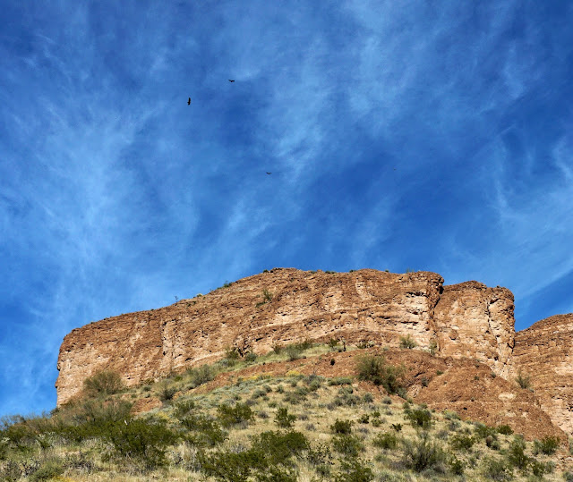
Back in the saddle, three midnight-black vultures circled through a luminous cerulean sky above an opaque, multi-hued overcliff. (THW, photo)
2 comments:
I believe ET 3 represents Electronic Traverse 3. WTB may be the survey party chief's initials or a traverse ID. There's additional interesting discussion of traverse stations at: https://forums.geocaching.com/GC/index.php?/topic/215784-traverse-station/
Jim, Thank you for your insights concerning the benchmark on South Butte. I directed readers to your comment. Debra
Post a Comment