Essence: "Little Picacho" is the informal name for Peak 2,614'. The imposing but delightful blade-like peak is one of thirteen legal summits in the serrated Sawtooth Mountains. It is only 16 feet lower than the range highpoint located within hiking distance to the north. In profile, the mountain resembles nearby famed Picacho Peak from which it gets its moniker. In contrast, climbers rarely visit the small volcanic range located west of I-10 and south of Casa Grande. The short climb to the airy peak should be attempted only by desert mountaineers. While there are dependable holds and the base rock is stable, steep and exposed pitches are troubled with loose debris. The Sawtooth Mountains are within the Ironwood Forest National Monument, administered by the
BLM.
Travel: In a high clearance 4WD vehicle, take Exit 200 from I-10 (Arizona City), one mile east of the I-8 exchange. Measure distance from the traffic light on the north side of the interstate; your mileage is likely to vary from mine. There are truck stops and gas stations at this exit. Drive south on paved Sunland Gin Road. The first traffic light in Arizona City is at three miles. Continue south with the Sawtooth range in clear sight. At 17.0 miles the paved road cranks west and becomes Aries Drive. At Silverbell Estates the paved road swings left. Go straight onto a dirt road prone to ruts--impassible when wet. At 20.8 miles turn north at a visitor information sign posted by the BLM. Open and close the barbed wire gate. The narrow road will leave desert pinstripes on the finish of some vehicles. Follow the fenceline: east, north, east, north. Enter the Monument at 22.5 miles. At 23.5 miles the road angles 45 degrees to the northeast. High clearance is required for steep pitches into and out of washes. Stay straight at a left branch at 24.0 miles. At 24.4 miles turn left/northwest. Park at 25.4 miles near the "Guzzler" (game water) on the topo. See the end of this post for a helpful travel map.
Distance and Elevation Gain: 2.1 miles; 1,000 feet
Total Time: 2:30 to 3:30
Difficulty: Off-trail; navigation moderate; Class 3 with considerable exposure; teddybear cholla hazard--wear long pants; carry all the water you will need and hike on a cool day.
Map: Greene Reservoir, AZ 7.5' USGS Quad
Distance and Elevation Gain: 2.1 miles; 1,000 feet
Total Time: 2:30 to 3:30
Difficulty: Off-trail; navigation moderate; Class 3 with considerable exposure; teddybear cholla hazard--wear long pants; carry all the water you will need and hike on a cool day.
Map: Greene Reservoir, AZ 7.5' USGS Quad
Geology Reference: Geologic Map of the Sawtooth Mountains and the North End of the West Silver Bell Mountains, Arizona Geological Survey, by Charles A. Ferguson, et al., 2022.
Reference to Sawtooth Mountain Peaks: The Desert Mountaineer cataloged his climbs (initially with desert peak luminary Bob Martin) for all 15 peaks in the range spanning from 1986 to 2011.
Historical Note: For those interested in a bit of technological spy history, there are some interesting artifacts in the area. You will find marked on Google Maps the Corona Satellite Calibration Targets. These are concrete geometrical shapes at ground level, some of which remain in excellent condition. A great description can be found on Wikipedia.
Date Hiked: January 15, 2023
Quote: If you think adventure is dangerous, try routine, it’s lethal. Paulo Coelho
Date Hiked: January 15, 2023
Quote: If you think adventure is dangerous, try routine, it’s lethal. Paulo Coelho
The final pitch to the summit spire looks more intimidating than it is. The passage reveals itself as you ascend. Be with the mountain, maintain steady concentration, and the scramble is joyous. (Thomas Holt Ward, photo)
Route: From parking, hike west-northwest to the northwest end of the summit ridge. Pitch southeast to the peak. Return as you came. The Greene Reservoir topo has 20-foot contour intervals.
The "Sawtooth Spire," Peak 2,392', tempts northeast of the parking pullout, elevation 1,750 feet. The Desert Mountaineer left a peak register in 1986 celebrating a "solid Class 4" climb.
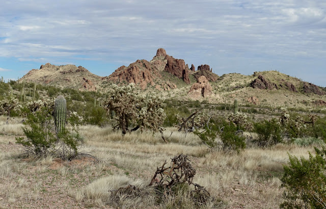
Hike northwest on a road passing an isolated stone mound, the "parking pinnacle." Immersion in Sonoran flora is immediate. Chainfruit cholla, saguaro, creosote, and paloverde are prolific.
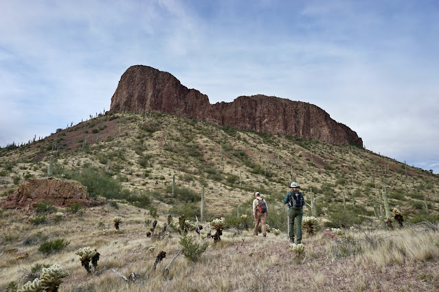
The faceted and perpendicular barrier wall of Little Picacho is visible throughout the approach. (THW, photo)
The track dips into and out of a small drainage at 0.1 mile. Leave the road soon after and maintain a west-northwest heading toward the saddle between peaks 2,614' and 2,630'. Dodging brush is easy enough. Keep an eye out for bighorn sheep known to frequent this range. We saw scat but no animals. (THW, photo)
Evidence suggested we were on a migrant route. There were periodic cairns, paint splotches, white arrows on boulders, and trail fragments--but no sign of recent use. The cairns pegged the way to the saddle through a minor cliffband south of a prominent cave. (THW, photo)
Gain the 2,110-foot saddle at 0.5 mile. Studying the mountain, a gash issues from the saddle between the false summit and the peak. However, this route exploits a weakness in the escarpment armoring, image-right. (THW, photo)
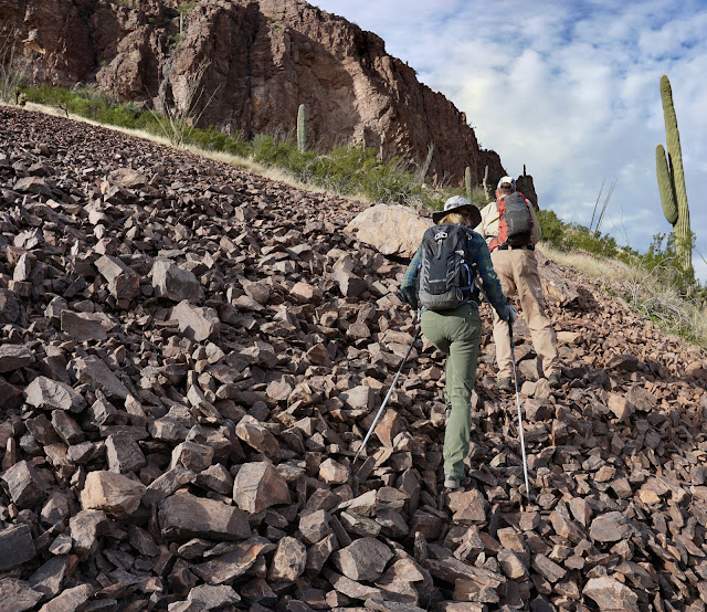
Do a rising traverse crossing swaths of scree, sharp-edged stone exfoliated from the rampart. (THW, photo)
Cliffside, we found significant stashes of trash in cavities--backpacks, shoes, drinking vessels, even a bed fashioned from a saguaro skeleton. Edge along the base of the cliff on a comfortable, if brushy, ledge. (THW, photo)
Migrants have documented three alternate routes to pass over or around the mountain with spray-painted numbers on the wall. At "3" we scouted around the corner and saw no break in the barrier wall for the next 100 yards. So we backed up a few feet and initiated our climb to the ridge.
The most challenging segment of the climb is from this initial pitch to the false summit. The terrain is steep and covered with loose material. Parties with more than two climbers need to be defensive, clearing constricted passages in pairs.
Round onto the northwest ridge at 0.8 mile, 2,340 feet. I found the look of the friable front-wall intimidating. According to the geology map sited above, the formation is composed of crystal-rich trachyte lava and lava breccia. There is a rapid succession of minor cliff bands to weave around and up through. Climbing is Class 3. Search out and test for reliable hand and footholds. (THW, photo)
Views expand as you mount the ridge revealing peaks 2,467' and 2,473' to the southwest. (THW, photo)
Poet Mary Oliver penned, "Attention is the beginning of devotion." Affection for the mountain builds as three climbers concentrate on their every move. (THW, photo)
As you gain elevation the composition of the stone transitions to Trachyte of Indian Head, a fine-grained, extrusive igneous light tan volcanic rock. Indian Head, Point 2,207', is an unranked summit south of Little Picacho.
Top out on the false summit at 0.9 mile, 2,560 feet. The spooky look of the final segment to the zenith has turned many hikers back. Perhaps that explains the register and ceremonial cairn at the mid-way point of the block ridge. Take heart. Our group of four thought the climb to the false summit was more challenging than the finish. If you got this far, give it a go. The 0.1 mile stretch takes about 15 minutes. (THW, photo)
Skirt a precipice on the ridgeline by dropping a few feet to the east and make your way into the saddle. The first slab might be considered the crux for its exposure. Bedrock holds are small but dependable. (THW, photo)
The razorback is three-feet wide in places. Below, a climber straddles one of the thinner serrations. If you have a stomach for (or even enjoy) exposure, the final pitch is great fun. As always let the ridgetop be your guide.
Elation! Stand on the summit pinnacle at 1.05 mile. The airy peak is preferred by raptors who can see unfettered into the blank immensity. With a rise of 544 feet and sheer cliffs on three sides, we could gaze for immeasurable distances over the desert playa to ranges disappearing into the blue distance. (THW, photo)
The peak register is protected in an ammo box. The most recent entry was eleven months prior in February, 2022. The notebook recorded informative notes about other peaks in the range. (THW, photo)
Southwest is the bulky magnificence of neglected Newman Peak and wildly popular Picacho Peak, both in the Picacho Mountains.
To the north, Peak 2,630', the highpoint of the range, is occasionally paired with Little Picacho. For a helpful description of the route over a complex topography please consult GlassMountains. (THW, photo)
Thank you, Dave Kohnke, for your capable leadership and calm, encouraging demeanor on this climb with the Southern Arizona Hiking Club. (THW, photo)
Addendum Photos
The Sawtooth Mountains shot from Sunland Gin Road: Sawtooth Spire, Little Picacho, Highpoint Peak 2,630', and Peak 2,417'.
This partial travel track should help you locate the start of the climb.


No comments:
Post a Comment