Travel: From Durango, drive north on US 550 for 35 miles to Coal Bank Pass. Turn left/west 0.1 mile north of the pass (mile marker 56.9), onto a dirt road that leads shortly to trailhead parking. There is a seasonal outhouse on the east side of the highway but no water.
Distance and Elevation Gain: 6.4 miles and 2,350 feet; Little Engineer adds 1.0 mile and 650 feet
Total Time: 3:30 to 5:30; add 1:00 to 1:30 for Little Engineer
Difficulty: Trail, off-trail; navigation moderate; Class 3+ with considerable exposure at the crux
Map: Engineer Mountain, Colo. 7.5' USGS Quad
Latest Date Hiked: August 29, 2022
Quote: The power of such a mountain is so great and yet so subtle that, without compulsion, people are drawn to it from near and far, as if by the force of some invisible magnet. Lama Govinda
The first dusting of snow on Engineer Mountain and Little Engineer in autumn enthralls. (Chris Blackshear, photo)
The mountain was sculpted by a 2,000 foot wall of ice sliding south during the Pleistocene. It was first scaled by H. G. Prout in 1873, a member of a geographic survey crew mapping the area with the Army Corps of Engineers. So, no, the peak was not named for top guns on the D&SNG Railroad, but rather, in honor of masters of geography and cartography.
Route: From the trailhead on Coal Bank Pass, hike north and then west on the Pass Trail to the Engineer Plateau and junction with the Engineer Mountain Trail. Leave the established trail and ascend the northeast ridge on a fragmented and unmaintained social trail. The blue-line route is an optional extension to Little Engineer.
Pass Trail
The first 2.5 mile jaunt up the Pass Trail accommodates people of all ages and abilities. In a rising traverse from the signed trailhead at 10,660 feet, the trackway plows through wildflowers so opulent and enthusiastic it is a wonder humans can carry on. A sprightly octogenarian is dominated by cow parsnip and mountain delphinium.
A few paces away a different arrangement enchants: little sunflower, Indian paintbrush, rayless senecio, Whipple's penstemon, osha, and columbine.
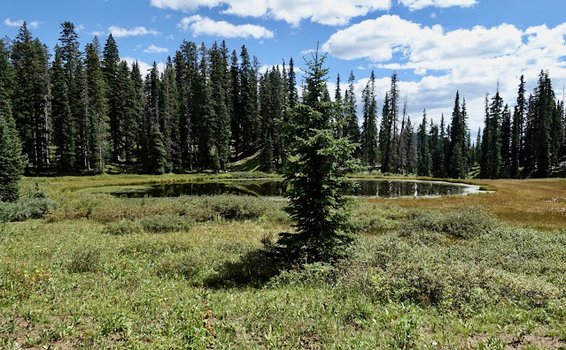
The footpath plunges into a deep and dark subalpine forest. In a mile, pass a perfect disk of water. Every season this pool grows smaller as it proceeds along the age-old Earth path, transforming from lake to meadow.
At 1.3 miles, queen's crown flourishes beside a trickling brook. Limestone boulders adjacent to the track are bejeweled with fossils. At 11,600 feet the path emerges from the woods onto a
broad swath of land, the Engineer Plateau. And now, for the first time, the traveler feels the pulling force of the mountain. (Chris Blackshear, photo)
The stately fallen conifer at treeline marks a favorite resting place, affectionately dubbed the Bus Stop.
Walk a short distance to the four-way junction with the Engineer Mountain Trail at 2.5 miles. Continue straight/west uphill to the solitary boulder, "Social Rock." In 2022, the soil surrounding Social Rock was so eroded it was poised to continue its inevitable downhill slide. (THW, photo)
Trail Note: A left/south turn on the Engineer Mountain Trail guarantees a premiere traipse through golden aspens in autumn. The trail drops 1,760 feet in six miles. The lower trailhead is accessed by turning west off US 550 at mile marker 52.2.
Engineer Mountain, the Climb
From Social Rock, ascend the broad, red northeast ridge of lower Engineer. The unmaintained trail is threaded, shattered, and tiptoe steep. The erosion from so many people going every which way makes this first push a marbly annoyance. Try to stay on the main trail hovering on or near the ridgeline. Toward the top of the red zone the trail penetrates the gray granitic layer.
This image looks back on the red zone and "The Fort", elevation 12,300 feet, a bivouac that serves as a comfortable and generous room-with-a-view for those who choose not to proceed. From here, the hike becomes a climb for experienced scramblers. Resist the urge to continue if you do not tolerate exposure or if small children are in your care. (THW, photo)
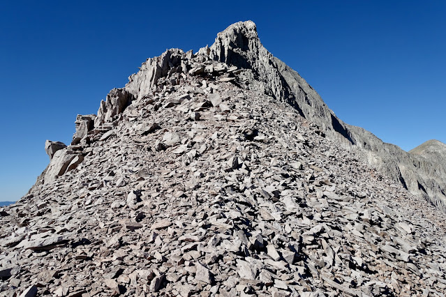
Engineer has some of the finest talus climbing in the local mountains. There is a hint of a trail up through the first blockfield.
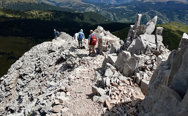
The crux awaits above the standing rocks.
Enter a three-foot slot and scramble easily up the initial ten feet, protected on two sides. Below, two downclimbing mountaineers are transitioning from the most exposed part of the crux into the slot. (Jeff Eisele, photo)
The squeeze narrows. The standard choice is to move up through a notch on the left/south side of the crack and onto the exposed face riddled with spiky nibs. Most are very solid, but test. The holds are blockier and the climbing less exposed if you stay very close to the crack on the right, as shown. Avoid wandering out onto the face. In about 50 feet you will come to the stone horn, pictured. An anchor may be set around this feature for people who wish to be belayed.
There is a second way to commandeer the crux. Instead of turning left at the notch, continue straight up the crack, shown. It leads to a chimney that rises vertically to the top of the crux. The rock is
excellent, the climbing relatively easy, but the exposure is chilling. This is the route my 12 year old (with nine
years of climbing experience) relished, but the chimney is not recommend by Earthline. (THW, photo)
Below, three climbers are descending the most exposed segment of the crux. I am positioned near the horn. This part of the climb (both up and down) requires absolute concentration, laser focus, and a good sense for the integrity of stone...or lack of it. The rock is reasonably well seated but test every hold. If you flow, you will mount the crux in about three minutes. (THW, photo)
Below, three climbers are descending the most exposed segment of the crux. I am positioned near the horn. This part of the climb (both up and down) requires absolute concentration, laser focus, and a good sense for the integrity of stone...or lack of it. The rock is reasonably well seated but test every hold. If you flow, you will mount the crux in about three minutes. (THW, photo)
When the pitch decreases, move back onto the ridge at first opportunity. This look-back snap shows a fragment of social trail coming up from the crux, a bit southeast of the ridgeline. If you opt for this trail, be sure to return to the security of the ridge promptly. (THW, photo)
This image was shot just above the previous one. Climbers are descending through another set of spikes and slivers of stone.
This image was shot just above the previous one. Climbers are descending through another set of spikes and slivers of stone.
The final scamper to the summit is pure Class 2 pleasure so long as you stay on the ridge. Do not get lured onto the southeast face as others have done.
Mount the surprisingly flat, linear summit in 3.2 miles. Top time depends on the weather. Engineer attracts electrical storms; reports of hair flying straight up are common. Some people tag the top and rush down because their descent anxiety gets the better of them. Resist. Spin around and revel in the great circle of the horizon punctuated lavishly by peaks as riveting as this one. Only in Colorado! (Chris Blackshear, photo)
A massive rock glacier flows from the north face cliffs. The enfolded green hues are cast from lichen growing on rocks, indicating the glacier is no longer on the move. (THW, photo)
Little Engineer
Roundtrip to Engineer's unranked west crown adds one mile and 650 feet of vertical. Begin by walking westward on the lofty, ten-foot-wide summit ridge. Look over the edges to see lobes of rock splaying out to the north and the south.
The descent to the saddle is steep and somewhat painstaking on small-grade talus that teeters underfoot. (THW, photo)
The 153 foot ascent out of the saddle, elevation 12,460 feet, is enhanced by larger plates of stone.
(Jeff Eisele, photo)
Crest Little Engineer at 3.65 miles. I have climbed Engineer repeatedly over two decades and it was a happy pleasure to finally visit the subsidiary peak in 2022.
If you are tempted to continue descending to the west, beware that some of my friends have made themselves miserable in the process. Avoid the northwest ridge. The terrain sucks you in. It looks good at first but gets ever steeper and has layers of cliff bands with boulders on the loose. Rather, retreat to the saddle and then drop south to almost 11,800 feet before circling around to the north side of Engineer. Endure the tedium of heading east across the rock glacier on the 11,700-foot contour.
Climbers returning up the backside of Engineer are rewarded with an astounding perspective on the sheer, ice-sculpted north face. (Jeff Eisele, photo)
This image looks east from Engineer to successive streams of San Juan peaks. Usually, we are looking at Engineer from far-flung mountaintops. Standing here, the reciprocal relationship is an earned, heartfelt pleasure.
This image looks east from Engineer to successive streams of San Juan peaks. Usually, we are looking at Engineer from far-flung mountaintops. Standing here, the reciprocal relationship is an earned, heartfelt pleasure.
Engineer is a half day hike. In the late afternoon of Summer Solstice, 2012, my partner and I summited unhurriedly in 1:45. We descended past spears of stone set ablaze by the sun-that-hesitates-to-set, re-entered the domain of flowers, enjoyed a toast to the sun at the Bus Stop, and ambled home through woods, surrendering reluctantly to the shortest night. Purple fringe, magenta paintbrush, and alpine avens were at peak flower power on the Engineer Plateau.
Winter Note
The Pass Trail is popular with snowshoers, skiers, and snowboarders. Park in the Coal Bank Pass lot on the east side of the road. The bottom part of the trail crosses below a major avalanche release zone. Slides have obliterated the trail, run across the highway, and buried the bathroom. For the initial climb, seek the protection of the trees to the north, avoiding the base of the slidepath. My favorite snowshoe heads southeast from the Engineer Plateau to Point 11,916', as this group is doing. (Chris Blackshear, photo)
.jpg)


