Travel: Old Sheffield Road (OSR) is off Highway 12 between Escalante and Boulder, UT. At mile marker 70 (where a cattle guard crosses the highway), turn south on a dirt road and zero-out your trip meter. At 5.8 miles in Big Spencer Flat, the main road goes right/south. Take the left fork trending east. The road narrows to a two-track and bogs down in deep sand near the parking area on a flat pad of grey stone at 6.9 miles. It is a good road when dry other than the sand hazard which you can avoid by parking earlier if you are in a 2WD with good clearance. Check road conditions by calling the Escalante Interagency Visitor Center: (435) 826-5499.
Distance and Elevation Gain: 7.0 miles; 1,750 feet of climbing. Note: in May, 2017, the OSR was blocked 0.25 mile before the standard parking. Adjust mileages accordingly.
Time: 4:30 to 6:00
Difficulty: Off-trail, no cairns; navigation challenging. Some hikers will want a 60 foot rope to descend the steep friction pitch into the pit (optional).
Map: Red Breaks, UT 7.5 USGS Quad
Reference: Netoff, Dennis I., and Marjorie A. Chan. "Aeolian activity at a giant sandstone weathering pit in arid south-central Utah." Earth Surface Processes and Landforms 34 (2009): 99-109.
Date Hiked: April 23, 2016
Quote: All this time I had thought that the land was something other than me...Now I could see. We had the same command, driven by the same fundamental longing. I had never been a separate creature from it, not once. All this time I believed that I had my own desires, my own hands. Laughable now. I have always been the land. Craig Childs
The massive Inselberg Pit as seen from Point 5,847'. (THW, photo)
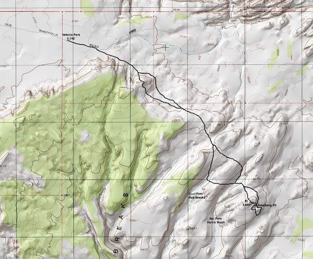
Route: The site lies within the Grand Staircase-Escalante National Monument. We had very little information going into this hike and the pit was hard to locate. We made plenty of navigational mistakes but they added to our pleasure and knowledge of the land. The map below and the accompanying photos should get you there most directly. From the parking area off Old Sheffield Road, walk southeast and climb Pt. 5,974' (or go around it on the east side). Next, gain the saddle between Pt. 6,015' and Pt. 5,887'. Cross the East Fork of Red Breaks Canyon and what I am calling, the North Fork of Harris Wash. Climb Pt. 5,847'. The pit is near the crest of this dome on the southeast side.
From the parking area at 5,740 feet, walk east-southeast down the two-track which soon degenerates into deep sand and then dwindles to a wide trail. To the right/south is a band of cliffs, the Red Breaks.
At 0.4 mile, leave the old road bearing southeast. Walk along the base of the Red Breaks, out far enough to avoid ravines. You may find fragments of a social trail in the sand. Before the deep sand gets annoying, intersect sandstone. The remainder of the hike is on slickrock.
Climb Pt. 5,974'. Yes, you may skirt it on the east side holding the 5,720 foot contour. We did that on our return and it is more efficient. However, there is much to be gained by climbing almost 300 feet to the top of the dome, reaching it at 1.2 miles.
It is a fun little climb to the crest. Behind me are the alluring landforms that lie between the Red Breaks and the Escalante River. Further east are the Henry Mountains. (THW, photo)
On the prominence the windblast is 60-plus mph and I literally cannot stand up. Super charged engines roar inside my ears. We are experiencing the aeolian process at work, the wind's ability to shape the surface of the Earth. From here, get the lay of the land and peg your next goal. Cross the undulating sandstone bench southeast until you are on the right/south side of Pt. 6,015', image-center, top.
Descend on rosy cross-bedding. Pocket sand gardens are protected havens for piñon-juniper and brilliant crimson Indian paintbrush. Splashes of green lichen favor small cracks and divots. Clumps of black moss cling steadfastly to the bedrock.
Polished and grooved ventifacts lay scattered about. If you accidentally kick one off-axis, it will take a thousand years for the aeolian process to create a new shape. Moqui marbles have been rolled by the wind into single layer clusters butted up against backstops. Mounds of turtleback weathering and bedrock polygonal cracks are typical of Lower Jurassic Navajo Sandstone. (THW, photo)
Initially we tried to walk around Pt. 6,015' on its left/east side but got cliffed out. Pass it on the right/south.
Reach the minor saddle between Pt. 6,015' and Pt. 5,887' at 2.2 miles. Now for the first time, you can see Pt. 5,847', the rounded dome just right of center at skyline in this image. The weathering pit is located near the crest on its backside. Left of Pt. 5,847' is a formation I refer to as Three Pinnacles. It doesn't much look like that from here but it will soon enough. Most notably, there are two sizable drainages between this location and Pt. 5,847'.
Cross the first watercourse, the East Fork of Red Breaks Canyon, at its head at about 5,700 feet, 2.5 miles, the most direct route. As indicated on my map, we crossed it somewhat deeply because it is irresistible. The floor is remarkably wide with waves of white rock. A startled coyote bolted. The stats given above assume you will do some exploring in one or both drainages.
Drop far enough into the North Fork of Harris Wash to avoid the cliff structure on its east side, crossing the floor at about 2.9 miles and 5,500 feet. The sand ripples and stone swirls on the smooth stone floor are astonishingly beautiful.
Climb Pt. 5,847', cresting at 3.2 miles. According to Netoff and Chan, the broad dome is subject to exceptionally strong south-westerlies, sand movers. The springtime prefrontal wind we experienced is even more accelerated. My companion is getting pummeled on the highpoint.
Just over the backside of the dome the Inselberg Pit is revealed. I was momentarily distracted by a plate full of Moqui balls. These concretions are created by the precipitation of iron oxide and are common in outcrops of Navajo Sandstone. Please do not succumb to the temptation to take one with you. (THW, photo)
The enormous weathering pit is both wondrous and unsettling. It is slightly oval, 200 feet across. The walls of the pit vary from sloping to vertical to overhung. Its depth ranges from 65 feet to 16 at the breached part of the rim where we may enter. The cylindrical pedestal is 30 feet tall. Three men provide scale.
Reach the access entrance at 3.3 miles. According to Netoff and Chan, the Inselberg Pit is distinguished from other giant weathering pits on the Colorado Plateau by its pillar and active sand dune. The reddish-orange color contrasts with bleached, light pink walls. While a small portion of dunal sand is derived from weathering of the pit floor and walls, most of the sand is transported into the cavity from other sources. Looking at the image below, on the far side from where I am sitting there is an aeolian groove aligned with prevailing wind--a sand funnel. (THW, photo)
Expecting to be alone, we were surprised to meet up with four Utah men who came in from Harris Wash. Not without its own navigation difficulties, they were elated to find the Cosmic Navel on their third try. They had a line secured to a small blackbrush shrub. I found the rope reassuring to get down the initial friction pitch to the augmented Moqui steps which are deep enough to descend without aid. With sticky shoes, some people will be able to make the downclimb without a rope. In this image, I am topping out after leaving the bowl. My flying pigtails are an indicator of wind velocity. (THW, photo)
A few people will be able to access the pit without a rope.
On the floor both the pinnacle and dune have a strong presence. The dune mounds up between the pillar and the south wall. It changes shape, height, and position with every strong wind event. Sand is siphoned into the pit and blown against the outer walls, pushing them back. It takes one thousand years or more to deepen the pit by a few centimeters. Accordingly, the Inselberg Pit is ancient. Estimates vary from 216,000 to 800,000 years old. (THW, photo)
Climb out and circumnavigate the pit on its south side, giving up and regaining 120 feet for a safe passage. In 0.2 mile, find the aeolian groove on the west rim. Walk down into the 30 foot-long, eight foot-wide funnel with its fluted bedrock floor. While running water did not create the groove, at one time in the distant past there was standing water, perhaps a simple water pocket, at this site. While all weathering pits must have standing water in their formative years, water no longer pools inside the Cosmic Navel but quickly drains through porous rock.
The funnel creates a Venturi effect, accelerating the wind by as much as 300%. I am crouching in the image below preparing to sit and scoot until my feet are braced on the rim lip. The windblast was capable of transporting me over the brink along with the sculpting sand. (THW, photo)
To return, continue around above the pit until you are between Pt. 5,847' and the Three Pinnacles.
Then bear roughly northwest and cross the two drainages. Regain the saddle south of Pt. 6,015'. You won't see Pt. 5,974' until you are on top of the next rise. This dome is your massive reassurance cairn signifying that you are on the proper route back to your vehicle. Skirt it on the east bench.
Our Earth, the preeminent artist amongst us, patiently created the weathering pit with her breath and grains of sand. Those of us who by providence, serendipity, or intention are blessed to see this masterful sculpture will surely judge it perfect, just as it is. And yet, the Earth's untiring work continues.
An important note from author Steve Allen about protecting endangered National Monuments in Southern Utah.


