Sunday, June 29, 2014

Indian Trail Ridge Along the Colorado Trail

Essence: Indian Trail Ridge is the great alpine connector, linking the San Juan Mountains with the La Plata Range via the Colorado Trail. The diversity and abundance of wildflowers is as big and bold as the continuous panorama. Design your hike from the Kennebec Pass Trailhead. Turn around at Taylor Lake or do any portion of the out-and-back to the Grindstone Trail. Finish with an optional loop through the "Boulder Playground" at the southern end of the ridge.
Travel: From the US 160/550 intersection in Durango, travel 11.0 miles west on US 160 to Hesperus. Turn right/north on La Plata Canyon Road, CR 124. Zero-out your trip meter. There is a brown, US Forest Service sign with mileages right after the turn. After passing the hamlet of Mayday, the road turns to smooth dirt at 4.6 miles. There are several established campgrounds in this area. In 8.5 miles the roadbed deteriorates with sharp, sizable rocks. At 12.1 miles the road splits; take the left track, FS 571. High clearance, 4WD is recommended from here. It is 14.2 miles to the Kennebec Pass Trailhead from US 160. Allow 1:00 to 1:30 from Durango.
Distance and Elevation Gain: 12.5 miles, 2,620 feet of climbing includes the Boulder Ridge loop
Time: 6:30 to 7:30
Difficulty: Groomed Colorado trail; navigation easy; no exposure; optional off-trail loop has two boulder fields
Maps: La Plata, Colorado 7.5 Quad, or Trails Illustrated No. 144, Durango-Cortez
Latest Date Hiked: July 13, 2024
Quote: Eastward the dawn rose, ridge behind ridge into the morning, and vanished out of eyesight into guess; it was no more than a glimmer blending with the hem of the sky, but it spoke to them, out of the memory and old tales, of the high and distant mountains.  J.R.R. Tolkien, The Lord of The Rings

Sky-high Point 12,181' is one of five numbered points between the Kennebec Pass Trailhead and the Grindstone Trail.

Route: A tangle of 4WD roads and trails pin-wheel off from the Kennebec Pass Trailhead at elevation 11,600 feet. Take a moment to be certain you are heading west on the Colorado Trail toward Taylor Lake. The lake, a popular destination, is a relatively flat 1.2 miles away on a groomed expressway of a trail.

Round the corner and Diorite Peak appears on the left. The southern end of Indian Trail Ridge (ITR) cradles the lake platform.

Just before the lake the trail splits. Turn right, staying on the Colorado Trail. Grindstone Trail, our northern turn-around, is 4.5 miles from here.

Skirt the north side of the lake and begin a 0.6 mile, easy 520 foot climb up to the ridge. The lake recedes while the east block of the La Platas rises to steal the show.

It is simply done and a great pleasure to leave the trail briefly to experience the high points. The 2,620 feet of elevation gain reflects touching the ridge crests while traveling north, and staying on the trail for the return. Below, hikers cross a neck on their way to Peak 12,338', the loftiest rise of the day. (LiDAR has increased the elevation to Peak 12,342' with a rise of 411 feet.)

From Peak 12,338', the view from solitary Lone Cone to the Lizard Head spire is a small slice of the horizon's unfettered circle.

The ridge affords a unique perspective on the west massif of the La Plata Mountains. The arc swings from Diorite to Sharkstooth Peak. Banded Hesperus Mountain, 13,238', is the tallest eminence in the range.

Hikers climb the rocky ridge south of Point 12,181'. Miles slide by in such a hurry on the immaculate Colorado Trail.

The ridge is studded with stone boys, but even without them it would be impossible to get lost on the restricted divide, even if the trail was obliterated by snow.

The flora on this hike was so rich, a friend exclaimed, "Ninety percent of Colorado's wildflower inventory is in bloom." Point 12,078' is where Old Man Of The Mountain lives in absurdly opulent conditions. He keeps house with aromatic phlox; tasty geyer onion and mountain parsley; his feminine companion, rosy paintbrush; and chiming bluebells. Osho must have been standing right here when he wrote, It is simply unbelievable how happy flowers are.

It is just shy of 5.7 miles to the Grindstone Trail. While our hike turns around here, there are options. The Colorado Trail continues north and just keeps on going all the way to Denver. For the Highline Loop, take the Grindstone west to abut the Bear Creek Trail in 4 miles. Turn south to reach the Sharkstooth Trail in another 5.75 miles. Go east on that trail for 3.3 miles back to Taylor Lake. Turn right and walk the 1.2 miles back to Kennebec Pass. That's adding up to more like 21 miles, not a mere 17 as the sign at the lake indicates. The Highline Loop was designated a National Recreation Trail in 1979 because of its extraordinary scenic value.

The Return:
From the ridge, Engineer Mountain dominates the San Juan earthline across the Hermosa Creek rift.

On a portion of the ridge, horizontal slabs of stone are strewn about. Linger amongst a stretch of rocks scattered carelessly like piles of books. The floral arrangement in early summer is arnica mollis.

To be a La Plata devotee, cypher and memorize the names of the mountains marching through the view finder.

These hikers are close to the point where the trail first met the ridge. If you've had enough, simply return to the trailhead as you came for a total of 11.5 miles. If you are game for a frolicsome highlight, by all means, pass through the "Boulder Playground." Leave the trail on the east side of a willow patch, heading for Saddle 12,080' and continue south on the ridge.

Hop along on stepping stones with resistant, crystalline veins.

Cross a swath of boulders and then climb gently for 170 feet to the final roll of the ridge at 12,250 feet. Pass two towers topping the point. Where the ridge splits, descend the southeast rib.

Enormous boulders teeter totter under foot.

Hikers are almost invisible clambering amongst boulders at the southern terminus of ITR.  Intersect the Sharkstooth Trail at 11,600 feet, turn left/north and walk 0.5 mile, passing Taylor Lake to link back with the morning's incoming trail. Turn right/east and retrace your steps 1.2 miles to the trailhead. (THW, photo)

In 2014, I walked ITR with a sizable group of friends and we frightened off the fauna. On a solitary trek I witnessed ravens, swallows at speed, tiny tweety birds foraging on snow patches, a curious ermine, marmots, mountain lion tracks in the muddy trail, deer, and large herds of elk in both the Hermosa Creek and Bear Creek drainages.

Tuesday, June 24, 2014

Hesperus Mountain, 13,238', Southern Approach

Essence: The rarely utilized Echo Basin Route approaches the west ridge of Hesperus from the south. Significant navigational challenges assures a day of solitude. On the mountain, ascend a stair-step progression of cliff-slope formations, staying on the ridge, off-trail, all the way to the summit. Hesperus Mountain is the highpoint in the La Plata range.
Travel: From the US 550/160 intersection in Durango, travel west on US 160 for 24.7 miles to the signed Echo Basin Road and turn right/north. Zero-out your trip meter. Stay on the main road, passing old homesteads and hay meadows. In 2.4 miles continue straight on FSR 566 when the road turns to gravel. The road deteriorates at 3.8 miles where winter plowing stops. The track climbs steadily through scrub oak to a cattle guard at 6.4 miles. Directly east is The Hogback. Beyond the guard are literally acres of blooming mule's ears in early summer. At 6.8 miles bear right at the fork, staying on FSR 566. Climbing, the road glides through an aspen forest. At 8.0 the road forks again; stay left. At 9.9 miles, go right. High clearance and good tires are necessary on the rocky track. At 11.5 miles bear left onto FSR 566G and drive downhill to Echo Creek. You will see Hesperus from the road. Park where large boulders prevent further travel, 11.9 miles. Allow 1:05 to 1:15 from Durango.
Distance and Elevation Gain: 7.5 miles, 3,560 feet of vertical
Total Time: 6:15 to 7:00 hours
Difficulty: Abandoned road, off-trail; navigation challenging; easy Class 3 scrambling with mild exposure
Maps: La Plata; Rampart Hills, Colorado 7.5' Quads
Latest Date Hiked: June 24, 2014
Navajo Prayer:
Mother in the earth
Father in the sky
From where the sun rises
To where the sun sets
To the south and to the north
All in my heart
All in my heart. (Scott Thybony, Burntwater, 1997)

Hesperus Mountain marks the northern boundary of the traditional homeland of the Navajo. It is the Sacred Mountain of the North. 

Hesperus Mountain as seen from Lavender Peak in November, 2007.


Route: Hesperus Mountain must be climbed via its west ridge. I have explored four approaches, one from the south, and three from the north. There is no easy way to summit. All routes present navigational challenges and demanding climbs. If you prefer to use the standard route, please consult Hesperus Mountain: Northern Approaches.

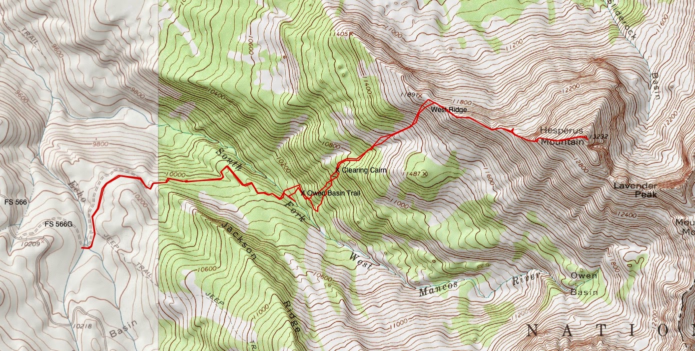
The Echo Basin Route is a gentler approach to the west ridge. However, it is 2.7 miles longer than the shortest northern approach and adds almost a thousand feet of vertical. Irrefutably, the final mile to the peak is one of the finest in the La Plata Mountains. Looking at the track below, the southern approach poses a substantial navigational challenge between the South Fork of the West Mancos River and the west ridge of Hesperus. The rest is simple.

From the parking area at 10,120 feet, cross Echo Creek and walk north on the abandoned road, shown.

The road bends around the base of Jackson Ridge. At the first fork, go left. At the second, bear right. Thimbleberry, columbine, golden banner, elderberry, and orange sneezeweed thrive. Keep a close eye and an intuitive feel on the road for it is disappearing from lack of use. Looking at the topography below, the navigational objective is to thread your way from the river (hidden) up through the woods to the west ridge.

In 1.4 miles, the road ends. Drop 100 feet on a steep use trail to the South Fork of the West Mancos River, 10,120 feet. Cross it on one of several logs. 2023 Note: Do not attempt to ford the river in high water. A young mountaineer was swept downstream and perished in June, 2023.

Clamber 100 feet straight up the slope to intersect the faint Owen Basin Trail. Leave some mark at this location so you can find your way home. Turn right/east and walk about 200 yards. We went a tad too far and ended up in one of many boulder fields.

Hike steeply uphill heading northeast, always northeast. Try to link clearings, staying near the aspens and small drainages. Flowing creeks harbor brookcress and Parry's primrose. When possible, avoid the conifers which cling to steeper slopes.

At about 10,600 feet, there is a cairn in a forest clearing. It is quite probable you will naturally come to this point. Continue through the clearing, do some more thrashing as you climb, always aiming northeast.

In 2.35 miles, at 11,200 feet, break free of the forest in a swale. Navigation from here is obvious. Whew! Simply step from one tundra tuft platform to another as you scale 700 feet up the steeply angled green slope.

The pitch is covered in edible valerian, medicinal osha, and the primitive green gentian (monument plant), shown looking down at the swale.

Intersect the west ridge just east of Point 11,891'. Most handsome Hesperus becomes your guide. The approach is essentially over with 1,341 feet of vertical remaining in the next mile to the summit.

As you move east, rolling up the ridge on a social trail, the standard route on the north side may be examined. Sharkstooth Peak juts from a massive rock glacier.


Phlox, looking like blinding snow patches, is having an excellent year on the ridge. Its wafting perfume induces alpine euphoria.

Upon reaching 12,300 feet where the real climbing begins, notice a social trail that leaves the ridge and makes for the south side of the mountain. This trail seeks to avoid some of the cliffs on the ridge proper. It baffles me that people use this trail which is a side-hill nuisance most of the way. The surface alternates between sink-up-to-your-ankles in shale, and slippery, resistant soil. The ridge, on the other hand, leads you up the mountain joyously. Begin the climb just to the left of the rock outcrop, shown.

Experience the alternating cliff-slope structure of the mountain while walking up through Mancos Shale to the base of the next cliff band. The climb is characterized by the rock so take a moment to read about the composition of the stone by geologist, John Bregar.

Geological Note:
Hesperus is part of the La Plata Mountain laccolith, which is an intrusion of magma between sedimentary layers, bowing the sediments up, where they get eroded off, and baking the sediments in close contact with the magma to hornfels.  The dark and light layers of rock that are so prevalent on Hesperus and Centennial are alternating layers of magma and baked sediment.  Generally, the dark layers are sediment, and the light layers tend to be the congealed magma or hornfels.  You could call the relatively thin, tabular bodies of magma sills, but really, the whole mass of the La Plata Mountain laccolith is a complicated mess of intrusive and sedimentary rocks.

While the cliff may be skirted on the right, it is a fun Class 3 scramble with secure holds to punch up the short wall.

Hold to the north edge of the ridge, surmounting the rising stone staircase all the way to the crest. The only exposure is adjacent to the precipitous north face of the peak.

Hesperus is the highest eminence in the La Plata Range. The summit is compact but the vista is compelling and commanding. (THW, photo)

Lavender Peak, less than a seemingly impossible mile away to the southeast, is captivating. Skilled climbers have, in fact, traversed the ridge from Hesperus to Lavender successfully.  Centennial Peak, 13,062', is the red banded mountain on the left.

Twirling towards the south, The Knife is held down by the Babcock Bad Boys on the left and Spiller Peak on the right.

Further south is the Four Peak Traverse and Helmet Peak.

In the southwest lies Mesa Verde and Sleeping Ute Mountain. Hesperus clearly predominates and deserves respect as the cardinal point of the North. Navajo land and life is secured within the circle of the sacred mountains (Trebbe Johnson). The eastern cardinal point is Sierra Blanca Peak in the Sangre de Cristo Range; in the south it is Mount Taylor in New Mexico; and in the west, Humphreys Peak in the San Francisco Peaks.

In the north is the familiar great swath of the San Juans. For the return, simply down-climb as you came. As you proceed through the woods, following your temporary cairns home, heed the advice of Rene Daumal in Mount Analogue.

When you strike off on your own, leave some trace of your passing which will guide you coming back: one stone set on another, some grass flattened by a blow of your stick. But if you come to an impasse or a dangerous spot, remember that the trail you have left could lead people coming after you into trouble. So go back along your trail and obliterate any traces you have left. This applies to anyone who wishes to leave some mark of his passage in the world. Even without wanting to, you always leave a few traces. Be ready to answer to your fellow men for the trail you leave behind you.

Climbing Hesperus was so deeply satisfying, I will forever carry the mountain in my heart to inform my days.

Wednesday, June 18, 2014

Durango's Silver Mountain, 12,496'; Deadwood Mountain,12,285', From La Plata City

Essence: The La Platas are the "Silver Mountains." A straightforward but somewhat arduous route topped by a peaceful, tundra/talus ridge, culminating at the La Plata's namesake mountain with a view of Durango. An essential climb for those who enjoy assembling a landscape puzzle that solidifies a sense of belonging to Place. 2023 Note: LiDAR has increased the elevation of Deadwood to 12,290' with a rise of 282 feet. Silver is adjusted to 12,486' with 1,336 feet of prominence.
Travel: From the US 160/550 intersection in Durango, travel 11.0 miles west on US 160 to Hesperus. Turn right/north on La Plata Canyon Road, CR 124. Zero-out your trip meter. Just after passing the hamlet of Mayday, the road turns to smooth dirt at 4.6 miles. There are several established campgrounds in this area. The trailhead is at 7.8 miles. Park on the right at placard displays for historic La Plata City. 2WD vehicles should be able to reach the trailhead.
Distance and Elevation Gain: 10.1 miles and 4,350 feet of climbing
Time: 6 to 7.5 hours
Difficulty: 4WD road, social trail, off-trail; steep slopes; navigation moderate; Class 2; short stretch of mild exposure
Map: La Plata, Colorado 7.5' USGS Quad or Apogee Mapping
Latest Date Hiked: September 4, 2023
Quote: To see the greatness of a mountain, one must keep one's distance; to understand its form, one must move around it; to experience its moods, one must see it at sunrise and sunset, at noon and at midnight, in sun and in rain, in snow and in storm, in summer and in winter and in all the other seasons. He who can see the mountain like this comes near to the life of the mountain, a life that is as intense and varied as that of a human being. Such is the greatness of a mighty mountain. Lama Govinda

Silver Mountain, left, as seen from Durango's Rim on February 20, 2014.

Route: Switchback east up a 4WD road located south of Neptune Creek. At the end of the road, take a social trail up the west ridge of Deadwood Mountain. Off-trail, follow the S-curve ridge to Silver Mountain. Retrace your steps.

From the parking area, 9,140 feet, wade across the La Plata River. To find the proper place, walk down the road a few paces, bear right, pass a primitive campground, and make for the river. Ford directly across from FSR 797 (Neptune) that punches up the other side. Note: You will be crossing the river boots-off; either barefoot or in sandals so don't attempt this in the spring run-off or after a monsoon.

In July, 2018, 20 yards downstream from the ford was a substantial, stable log. If present, cross it. Note: This log was washed away in spring runoff, 2019.

Walk up the steep 4WD road. Occasionally it is clear; often trees are strewn across. Frankly, this eternal segment is rather tedious and you will welcome the company of a friend. Or, enjoy the rhapsody of  woodland flowers such as sunny and sprightly heart leaf arnica.

Old mining tracks branch off. Stay on the main road for 1.5 to 2 hours. At 3.3 miles, 11,660 feet, the road splits and there are US Forest Service signs prohibiting further vehicle travel in both directions. The ridgeline social trail begins here and is serviceable all the way to Deadwood's crest. The rounded, wooded ridge is somewhat steep but pleasant.

Rise through the krummholz and bust out into the alpine. Thus begins one of the most exceptional ridge hikes in the La Platas. The sight lines are limitless and the route to the summit is obvious on broken talus.

Crest Deadwood Mountain at 3.8 miles. Net elevation gain is 3,200 feet thus far so a big chunk of the day's climbing is accomplished. Look southwest to appealing Ohwiler Ridge and directly south to Baldy Peak, 10,868'. It is the shortest mountain in the La Platas but one of the most difficult to achieve because of private property issues. Below, the summit cairn on Deadwood Mountain is image-right. This electrical storm blew up in minutes. (THW, photo)

Silver Mountain is commanding and the next 1.25 miles are pure pleasure, taking 45 minutes to an hour. Below, hikers walk southeast following the ridge.

Alpine flowers delight along the way. Mid-summer, magenta paintbrush are profuse as well as mouse ear chickweed, old man of the mountain, moss campion, deep rooted spring beauty, sky pilot, purple fringe, alpine sage, and even a tiny patch of forget-me-nots. In this early-season image, phlox is having a very good year. Get down and sniff this plant for an explosive whiff of euphoria.

Scrutinize Silver Basin on the east side of the ridge for the local elk herd grazing in the tundra.

Clamber over a roller to the low point between the peaks at 12,020 feet. Below, hikers are on a mildly exposed social trail on the north side of the ridge with views of Baker Peak and Lewis Mountain. There is 500 feet of climbing remaining from the saddle. (THW, photo)

The final push up Silver's west ridge is on small talus and tundra with a developing social trail. It will take anywhere from 2:40 to 4 hours to reach the crest from the trailhead with 3,850 feet of gain over 5.05 miles. The summit of Silver Mountain is as broad and welcoming as you imagined it to be when seen from town. Durango is clearly visible from the peak. Below, friends are contemplating the West Block of the La Plata Mountains across the canyon. In the center of the horizon is the West Babcock to Spiller ridge, The Knife. The five ranked La Plata thirteeners are all visible from Silver Mountain.

Your gaze is likely to be pulled back to the beautiful S-curve you just walked upon, shown below. Across the valley is the Four Peak Traverse. If your goal is simply to experience Silver's summit, the easiest way home is to go back the way you came.

These hikers are returning to Deadwood. It looks and feels like a ranked peak but doesn't quite make the 300-foot cut with just 265 feet of prominence. However, given the rollers there is over 400 feet of climbing back to the Deadwood summit. (THW, photo)

Friends walk down the road returning to the trailhead in La Plata City.

Traverse to Baker Peak, 11,949'

For years we tacked Baker onto our Deadwood and Silver climb. We’d start in La Plata City, climb the three peaks, return to the Silver-Baker saddle (11,700 feet) and descend Tirbircio Creek. Now that bailout is off-limits because of a small strip of private property at the confluence of Tirbircio Creek and the La Plata River. Therefore, if you want to climb Baker Peak, lovely but not ranked, you will have to do it as an out-and-back from Silver Mountain.

The traverse adds two miles total and 1,200 feet of vertical: 350 feet going over and 850 feet coming back. Alternatively, climb Baker Peak from Eagle Pass and Puzzle Pass and throw in the traverse to Silver. Follow the link for a description of the traverse.

This image was shot from the south ridge of Baker Peak. The crux of the traverse is the north face of Point 11,818', image-center. (THW, photo)

Baker Peak from Silver Mountain, image-center-left.
 

Historical Note
La Plata City was founded in the early 1880's. As the residential and commercial hub of the La Plata mining frontier, it had a peak population of 1,000. Ore deposits were low grade and limited so mining operations were not profitable. By the 1930's, the humble homesteads, post office, school, and grocery were boarded up or destroyed and the people moved on. (Courtesy, John Sanders)


Following are some of the flowering plants I have seen on this hike: wild iris, lupine, delphinium, white violet, purple violet, red columbine, white peavine, purple vetch, nine bark, Jacob's ladder, senecio (pakera), heart leaf arnica, false Solomon's seal, valeriana occidentalis, ball-head waterleaf, baneberry, Richardson's geranium, elderberry, thimbleberry, native honeysuckle (twinberry), strawberry, whiplash daisy (fleabane daisy), Brandegee's clover, mountain parsley, kittentails, candytuft, draba, king's crown, bluebells, alpine avens, sky pilot, wall flower, alpine sage, tansy aster, mouse ear chickweed, deep rooted spring beauty, snowball saxifrage, alp lily, American bistort, geyer onion, old man of the mountain, rosy paintbrush, moss campion, and alpine clover. Harebell were having a banner year in 2018. (THW, photo)