Essence: Our ambitious plan was to climb three ranked summits and one marked point on the northeast to southwest flowing divide east of the Los Pinos River and west of Weminuche Creek. We thought it was a given we could traverse from Graham Peak to Three Sisters Peaks, South, over Point 12,016', and finish on Granite Peak, our primary objective. We summited the first three and poked at Granite but it was Class 4 so we agreed to return and investigate a south ridge approach. The Pine-Piedra Trail is disappearing. We managed to hang on to it for the first mile. Highlights of the hike include the mixed geology at the limestone-granite contact, the aesthetically pleasing southwest ridge
of Graham Peak, the community of limestone blocks south of Three Sisters Peaks, the granite structure of Point 12,016', and expansive views into the mountains of the Weminuche. The ridge has a string of ultra steep intervening knobs, deadfall, and rough surfaces. There are but few names in peak registers and consequently, there are no social trails. The divide is crawling with bear, elk, deer, and lions--game trails are occasionally helpful. LiDAR has adjusted the elevations thus: Graham Peak,12,533', rise 2,562 feet; Three Sisters Peaks, South, 11,884', rise 339 feet; Point 12,016', 12,041', rise 250 feet; and Granite Peak, 12,155', rise 623 feet. The divide is on the Weminuche Wilderness boundary and managed by the San Juan National Forest.
Travel: From US 160 in Pagosa Springs, turn north on Piedra Road and measure distance from there. Past the Stevens Field Airport, pavement ends at 6.0 miles upon entering the San Juan National Forest. The road becomes FSR 631. Stay on this 2WD road (moderate clearance required) all the way to the trailhead. The roadbed is a mix of washboard and smooth magnesium chloride, broad, graded, and fast. At the split at mile marker 13, follow the sign for Williams Creek Reservoir. At 15.1 miles, enter Hinsdale County and cross the Piedra River. Pass the Piedra River Trailhead and Bridge Campground. At 21.1 miles, FSR 640, Williams Creek Road, leads to three beautiful campgrounds. Staying on FSR 631, cross the Weminuche Valley and go through an open gate at 23.7 miles. The road narrows as it winds up the hillside. It is a shelf in places but never scary. The Sand Creek Trailhead is on the right at 33.3 miles. Soon after, the dirt road is prone to ruts and puddles. The Coldwater Trail south of the road signifies the trailhead is near. Watch for the Pine-Piedra Trailhead sign 50 yards up the hillside north of the road at 38.7 miles. We camped off the Coldwater spur. Our odometer tends to underestimate mileage. Allow 1:45 from Pagosa.
Travel: From US 160 in Pagosa Springs, turn north on Piedra Road and measure distance from there. Past the Stevens Field Airport, pavement ends at 6.0 miles upon entering the San Juan National Forest. The road becomes FSR 631. Stay on this 2WD road (moderate clearance required) all the way to the trailhead. The roadbed is a mix of washboard and smooth magnesium chloride, broad, graded, and fast. At the split at mile marker 13, follow the sign for Williams Creek Reservoir. At 15.1 miles, enter Hinsdale County and cross the Piedra River. Pass the Piedra River Trailhead and Bridge Campground. At 21.1 miles, FSR 640, Williams Creek Road, leads to three beautiful campgrounds. Staying on FSR 631, cross the Weminuche Valley and go through an open gate at 23.7 miles. The road narrows as it winds up the hillside. It is a shelf in places but never scary. The Sand Creek Trailhead is on the right at 33.3 miles. Soon after, the dirt road is prone to ruts and puddles. The Coldwater Trail south of the road signifies the trailhead is near. Watch for the Pine-Piedra Trailhead sign 50 yards up the hillside north of the road at 38.7 miles. We camped off the Coldwater spur. Our odometer tends to underestimate mileage. Allow 1:45 from Pagosa.
Distance and Elevation Gain: Roundtrip to Graham Peak: 5.6 miles, 2,600 feet; our circuit: 10.0 miles, 4,100 feet
Total Time: Graham Peak, 4:00 to 6:00; allow several more hours if you explore additional peaks.
Total Time: Graham Peak, 4:00 to 6:00; allow several more hours if you explore additional peaks.
Difficulty: Trail, primarily off-trail; navigation challenging; Class 2 with no exposure (Granite Peak is Class 4 with exposure, depending on route.)
Map: Granite Peak, Colorado 7.5' USGS Quad
Date Hiked: June 19, 2024
Quote: It was easy here to forget the world of man, to relax into this world of nature. It was a world that compelled all our interest and concentration and put everything else out of mind. Margaret Murie
Map: Granite Peak, Colorado 7.5' USGS Quad
Date Hiked: June 19, 2024
Quote: It was easy here to forget the world of man, to relax into this world of nature. It was a world that compelled all our interest and concentration and put everything else out of mind. Margaret Murie
Weathered granite features enthrall on the summit of Three Sisters Peaks, South. The flowing alpine tundra on Graham Peak (image-center) contrasts with the balance of the scrappy, undulating ridgeline. (Thomas Holt Ward, photo)

Route: From FSR 631, ascend north on the Pine-Piedra Trail. If you lose it as we did, from 11,100 feet, follow the subtle ridge to the divide. Hike northeast to Graham Peak. This is the destination for most hikers. For the traverse, continue southwest on the ridgeline and climb Three Sisters Peaks, South and Point 12,016'. Strong climbers can take a shot at Granite Peak. There is no easy way back down to FSR 631 from Point 12,016'. The blue-line route is merely what we'd try were we to repeat this hike.

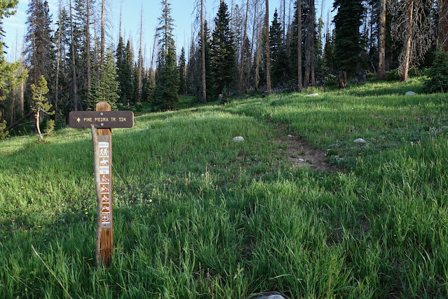
The Pine-Piedra Trail sees so little use there is no official pullout on FSR 631. Pick a wide spot on the road, elevation 10,100 feet, and hike about 50 yards up the slope to the trailhead. Trail # 524 is open to hikers and equestrians only.
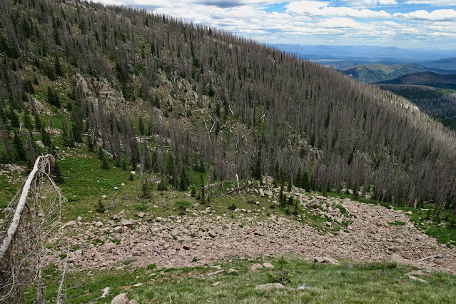
The forest has been ravaged by beetles. About 40 percent of the conifers are alive. Yes, it is disheartening and may partly explain why so few hikers use this historic trail. We saw just one boot print over the course of our entire hike. I'd like to encourage hikers to come out and help keep the trail a living passageway. Holding a north bearing, the trail proved to be an immense help getting to the divide. Flora is taking over the thin thread in places. When the path is hard to decipher, look for log cuts made over the decades. We stepped over deadfall throughout the hike.

The trail stays east of a tributary of Coldwater Creek. At half a mile switchbacks that are not on the Granite Peak quad moderated the grade. While we didn't see wildlife on our hike, we were not alone. We saw the scat and tracks of mountain lions, bear, deer, and elk. Wildflowers were exceptional. I recorded 57 species of blooming flowers, listed at the end of this post. Cross a secondary drainage at 1.0 mile. Surrounding rock was limestone all the way to the divide. At elevation 11,100 feet we lost the trail at a distinctive limestone wall about four feet tall, shown. From there the rest of the hike was off-trail so if you find it difficult to keep track of yourself without a distinct trail, this hike is not for you.

We turned northeast and followed a subtle ridge for about 200 feet, then arced northwest at about 11,400 feet, dodging deadfall all the while.

At 11,500 feet we caught our first up-close view of Graham. We were racing rain all day and struggled with lighting for photographs. (THW, photo)

Right on the ridgetop at 11,680 feet a steel lattice plate covered a vertical mine shaft that plummeted into darkness.

From there, the way to the divide was obvious.

We ascended through slabs and blocks of limestone.

Gain the divide at 2.0 miles, 11,980 feet. The ridge is the location of the granite-sedimentary overlap. Having grown up in the Sierra Nevada Mountains, granite is my favorite stone. If you feel similarly this stretch through intrusive granite with large quartz crystals and pink feldspar will light your fire.
Graham Peak
Graham Peak is 0.8 mile to the northeast. There are three intervening rollers all easily mounted. Initially, we used a scrap of the Pine-Piedra Trail to flank the first one on the west side.

I love the form of this mountain. It has the biggest swath of alpine tundra this hike offers. The divide was covered with elk scat and the scent of animals was strong. We searched the slopes for game but didn't get lucky. (THW, photo)

The final push is moderately steep. Footing is excellent on plant platforms.

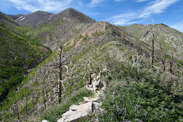
Look down-ridge for a visual preview of the entire traverse to come. (THW, photo)
Mount the broad summit of Graham Peak at 2.8 miles. The peak register was placed in the summit cairn, a five-foot-tall aesthetically pleasing arrangement of granite stones. According to the National Geodetic Survey (1960), the "station mark" is an aluminum tablet set in a granite boulder and the "reference mark" is an eight-foot-tall rock monument with a six foot base. (THW, photo)

The tallest peaks in the Weminuche Wilderness are showcased from the Needle Mountains to the Grenadier Range. (THW, photo)

Peak 12,442' to the north is astoundingly beautiful but looked like a time sink so we neglected it. For those interested in tackling the legal summit, a friend stayed directly on the ridgeline to the summit and returned on remnants of the Pine-Piedra Trail.

Three Sisters Peaks, South
Navigation is simple to this ranked peak. Hold to the ridge crest. At 3.6 miles you will be back at the upcoming intersect. This is the only reasonable exit for hikers whose primary goal is Graham Peak.

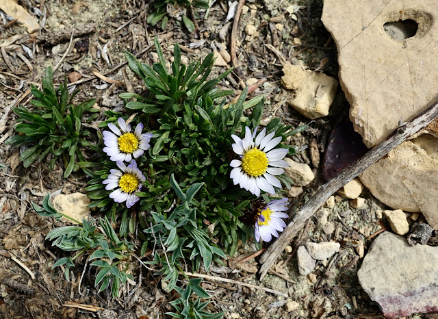
For those going on to Three Sisters Peaks, South, it's a 1,000-foot loss from the summit of Graham to the 11,540-foot saddle. We were fortunate to see Easter daisy (Townsendia rothrockii) blooming all over the ridgetop on this stretch. It is a perennial forb endemic to central and southwestern Colorado occurring from 8,000 to 13,500 feet on exposed limestone and sandstone. Townsendia rothrockii is a rare species with only 35 known occurrences. The Colorado Natural Heritage Program ranks Easter daisy imperiled in the state.
From the saddle the summit is due west with two intervening forested rollers. The first is steeply pitched. A game trail scratched in the dirt was helpful. I came across a large boulder that had recently been turned over by a bear looking for insects, earthworms, and other invertebrates.

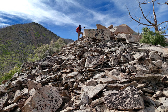
Both knobs are extrapolated at 11,780 feet on the quad but the second is higher. The image below depicts the crest of Three Sisters Peaks, South from the west side of the second roller. The ridge broadened and mellowed out as we closed in on the summit.
Crest the southernmost highpoint on Three Sisters Peaks at 4.7 miles.
There is nothing particularly striking about this summit. However, it
does have a captivating overlook with weathered granite features in the
foreground and Graham Peak off in the distance. (See the feature photo
at the top of this post.)

Point 12,016', "East Granite"
One of my favorite segments of the entire hike is the stretch between Three Sisters Peaks and Point 12,016'. Below, we are descending to the saddle on a delightful limestone ridge. Point 12,016' is the next prominence and Granite Peak is just beyond.

We made use of a game trail on the west side of the limestone nose.

It dropped us into a spectacular cluster of scattered and shattered blocks.

After descending into a second 11,540-foot saddle we were confronted with yet another steeply pitched knob. Flanking it will take you off route. Go straight up on a good surface and top out at 11,700 feet.

While it is a high-angled push to the crest of the point, shown, there are treasures along the way.

There is a gash on the west side of the ridge revealing the true granitic nature of this unranked summit. (The rise is 250 feet, 50 feet shy of the 300-foot requirement for a legal summit.) (THW, photo)

Pause and experience the presence of these powerful stone beings.

Hikers on the traverse will walk by this near-vertical granite wall. (THW, photo)

The mountain swings around in a small arc to the magnificent summit at 5.9 miles. We were simply elated with the environment on this little crest, informally named "Granite East." And yes, there is a peak register. (THW, photo)

Graham Peak is a respectable distance away.

This is a good place to sort out the landscape to the northwest. The Los Pinos River is nearly 4,000 feet below in the first trench. The next ridgeline has a string of 12,000-foot peaks, including Emerald Benchmark. Next, is the Lake Creek drainage flowing from popular Emerald Lake. The flat plateau further west is an extension of Cave Basin.

We got excited about this hike when we were standing on the Dollar Lake Overlook at the end of the Cave Basin Trail in 2023, shown. On the horizon line is Graham Peak (left of my partner). Point 12,016' is the softly rounded prominence to the left of Granite Peak.

The blue-line route on my map above looks like a plausible descent route but I can't vouch for it. The upper ridge flowing southeast from Point 12,016' looks like a fascinating curved limestone structure followed by heavy woods (with a chance of considerable deadfall). The ridgeline is subtle and you would have to be a skilled navigator to pull this exit route off.
Granite Peak Attempt
From Point 12,016', Granite Peak looked close and not all that tough so we went for it. We learned the mountain is deceiving. It is much more difficult than it appears.

Our plan was to climb the wall in the vicinity of the patch of snow, shown below, and ascend the green ramp.

The front wall was solid Class 4 and we weren't up for it so deep into the hike.

We dropped below the wall and started climbing the first available chute. It was steeper and slicker than it looks in this photo. I was barely clinging to the side of the mountain. Self arrest in the event of a tumble was doubtful.

We backed out and sneaked around into the next chute. We climbed to 11,900 feet where we were confronted with formidable chaos. We still had 250 feet to climb (and a very long drive home) so we called it a day. We have two friends who handily climbed the Class 4 wall and proceeded to the summit from there. So, climbers take heart.
Back to the Trailhead
We side-hilled over to the southeast ridge of Point 12,016', hitting it at 11,640 feet, below the curved, open limestone feature.
I swung around and snapped Granite Peak from our traipse to the ridge. Clearly, there is a straightforward, mellow ascent from Granite's south ridge. If we're back in this remote area, we'll try again.

We continued down-ridge bearing southeast. A quick perusal of our route (black-line on my map) indicates we repeatedly slid off the broad ridge erring to the south, and correcting. In a mix of limestone and sandstone we found scattered pieces of banded chert. (THW, photo)

At 11,100 feet the ridge became even more amorphous. It was a tough hike out clamoring over deadfall. We met up with an old roadbed at 10,160 feet, and followed it down to FSR 631 at 10,000 feet, one mile from the Pine-Piedra Trailhead. This image was shot from the road looking back up at the curved limestone structure on the southeast ridge of Point 12,016'.

Following, is the list of blooming wildflowers in order of appearance: mouse ear chickweed, purple vetch,
strawberry, white peavine, Richardson's geranium, delphinium, mountain parsley, fairy candelabra,
golden banner, elderberry, purple violet, draba, Geyer's onion, native honeysuckle, orange sneezeweed, golden groundsel senecio, Solomon's seal,
elegant death camas, meadow rue, Jacob's ladder, anemone, king's
crown, columbine, glacier lily, current, gooseberry, mountain
bluebell, wallflower, Easter daisy, clover, old man of the
mountain, red columbine, edible valerian, kittentail, globe flower,
snowball saxifrage, sky pilot, alpine sage, alpine avens, moss campion, alpine sandwort,
pygmy bitterroot, sibbaldia, heart leaf arnica, osha, Indian paintbrush, western valerian, alpine
phlox, myrtle blueberry, snow buttercup, Parry's primrose, ivesia,
marsh marigold, ball-head waterleaf, nine bark, green gentian, and plantainleaf buttercup, shown. (THW, photo)