Travel: Hike begins on Black Bear Pass. In a 4WD-low vehicle with high clearance, turn west from US 550 at mile marker 80 on San Juan County 16, FSR 823. (The track becomes one-way to Telluride at mile 6.25.) Much of the road is a suspended shelf. Bedrock makes for ground clearance problems; there is little wiggle room. Branch right at one mile. There is one very steep, exposed segment where traction is an issue. Arrive at the roomy pass in 3.2 miles. Allow 1:45 from Durango.
Distance and Elevation Gain: 6.5 miles; 2,200 feet of climbing
Time: 5:00 to 6:00
Difficulty: Chiefly off-trail, some historic mining roads; navigation moderate; north ridge of Trico has moderate exposure and Class 3 scrambling on loose rock
Map: Ironton, Colorado 7.5 Quad
Latest Date Hiked: September 13, 2015
Quote: The rock changes, the channel changes, the wind just carries air from one place to another, more constant than the rock. The rock is ephemeral, the wind, eternal. Ann Zwinger
Mailbox whimsy on Imogene Pass.
Route: The figure eight hike begins at Black Bear Pass. Go north, staying on the ridgetop, cresting Trico Peak, Peak 13,510', and Telluride Peak. Upon reaching Imogene Pass, turn essentially south, visiting Ptarmigan Lake. Return to the south ridge of Peak 13,510' via a tundra bench. Divert from the ridge at the saddle north of Trico Peak. Go southwest and join the Black Bear Pass road. Walk south to the pass.
Park at the top of Black Bear Pass at 12,840 feet. Mount Sneffels, 14,150 feet, is directly above the sign.
From the parking area climb the rounded south ridge of Trico Peak. A social trail assists with this quick and easy, if steep and scrabbly, climb.
Attain Trico Peak, 13,321 feet, in 0.6 mile. The name derives from Tri-County. San Juan, Ouray, and San Miguel counties converge at this apex. The two sides of this mountain are starkly different. The descent looks improbable, if not impossible. There is a way but it is not for everyone. This is the only scramble of the hike.
Stick to the ultra steep, thin ridge. Don't trust the footing--big slabs are on the move. Hand holds on anchored blocks make the difference. Be methodical; take it slowly. Below, I've reached the red layer where the pitch eases.
(THW, photo)
Bottom out at 12,850 feet, one mile. The mining track heading left/southwest, shown, is our exit route at the end of the hike. Peak 13,510' is in the distance.
Stay on the ridge over Pt. 12,938'. The appealing layered rock stacks are extrusive igneous San Juan volcanics. The stone cleaves into thin slabs or sheets that cover the walking surface for much of the journey.
Cross an old trail bifurcating the pass at 12,870 feet. The climb to Peak 13,510' is gentle and grassy. Reach the summit at 1.8 miles and find a peak register. The prominence has an unobstructed view of Telluride. Look down on the infamous Black Bear Pass road where it drops out of sight at Ingram Falls. West, the string of peaks on Ballard Ridge stand in front of the Wilson group and the distant solitary landmark, Lone Cone.
Mount Sneffels Wilderness is northwest.
Swing along an arc to handsome Telluride Peak, staying on the scalloped and precipitous west edge of the ridge. Walking is easy and visually stunning.
Pass directly above Ptarmigan Lake where you can study the return route.
The 13,240 foot saddle is not quite deep enough for Telluride Peak, 13,509 feet, to qualify as a legal summit. However, both Trico and Peak 13,510' are ranked peaks. The gentle climb up the south side is adorned with lovely slabs. The highpoint is just west of the ridge. Reach the capstone at 2.6 miles.
Ajax Peak hides the town of Telluride. Take in the sensational view of Imogene Pass and beyond it, Chicago Peak and United States Mountain. A social trail is well established to Imogene Pass. Go over Pt. 13,365'. Visit the Fort Peabody Guardhouse, stabilized by San Miguel County. Wood carved inscriptions date to 1904.
Reach Imogene Pass, 13,114 feet, at 3.4 miles, our northern terminus. The pass is typically festive with 4WD aficionados.
Walk east on the Imogene Pass Road to the first right at 3.6 miles, following signs to the Overlook. Go around a gate and follow the road south, passing scattered mine artifacts while descending to Ptarmigan Lake at 12,939 feet. The Reds dominate east of Hwy 550.
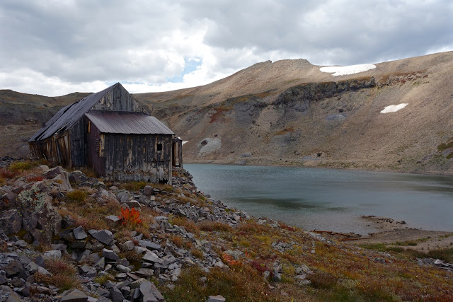
Stay on the road on the east side of the lake, passing a picturesque but disintegrating lakeside house at 4.3 miles. Mining relics litter the area.
At 4.4 miles, leave the road and climb the rocky slope south of the lake on an historic trail. It takes off left/east of the orange gully, image-left.
Do a rising traverse southwest to about 13,200 feet. Mid-summer, the tundra is lush with rosy paintbrush, purple fringe, daffodil senecio, columbine, and queen and kings crown. Hold this contour, passing west of Pt. 13,268', until you are back on the ridge south of Peak 13,510' at 5.3 miles. If Pt. 13,106' looks too appealing to miss, tag it and then go west to the ridge.
Go back over Pt. 12,938' to the saddle at 12,850 feet, 5.7 miles. At the base of Trico's north ridge, leave the spine on the abandoned road heading right/southwest. The objective is to return to Black Bear Pass without re-climbing Trico Peak, shown.
The mining track was intact in 2011 but sloughing rock has obliterated some of it. The route is a little rugged but serviceable. When the road peters out, find a good place to cut down to the Black Bear Pass road. We hit it at 6.1 miles, 12,650 feet. Turn left and walk 0.4 mile back to the pass.


No comments:
Post a Comment