Essence: The climb to Mount Huffman is as playful as hiking gets in the desert. Mount a solid slab of stone. The mountain is located on the northeast wall of the Chisos Basin along an arc of peaks ringing the enormous eroded bowl. The short, half-day hike begins from Panther Pass on the divide between Green Gulch and Chisos Basin. Mount Huffman has a triplet of prominences. The summit is northwest of Point 6,300'. Both are easy scampers for hikers comfortable with off-trail terrain. The "Huffman Pinnacle" is technical. The peak is named for Calvin C. Huffman, a Texas legislator who introduced the bill to provide funds to create Big Bend National Park. The 801,000-acre park was established in 1944.
Travel: Park in the lot for the popular Lost Mine Trail. It is on the south side of Basin Road just west of Panther Pass. The lot fills early.
Distance and Elevation Gain: 1.5 miles; 1,000 feet
Total Time: 2:00 to 3:00
Difficulty: Off-trail; navigation easy; Class 2+; mild exposure
Maps: The Basin, TX 7.5' USGS Quad; or, Trails Illustrated No. 225, Big Bend National Park
Park Fees and Camping: Please link to the Big Bend website for current information.
Date Hiked: October 7, 2022
Song: I was so much older then, I'm younger than that now. Bob Dylan
The imposing east-facing cliffs of Point 6,300', the Huffman Pinnacle, and the summit of Mount Huffman are seen from a pullout north of Panther Pass in Green Gulch. See SummitPost for an exposed Class 4 route from this location.
Route: Of note: Mount Huffman does not appear on The Basin quad but it is printed on the Trails Illustrated map. Panther Pass appears on the quad but not Trails Illustrated. From Lost Mine Trail parking, walk up the road to Panther Pass. Ascend the south ridge of Point 6,300'. Descend northwest to the 6,140-foot saddle and climb the southeast ridge of Mount Huffman.
From Lost Mine Trail parking, elevation 5,720 feet, walk up Basin Road to Panther Pass, 5,780 feet. Below, hikers on the Lost Mine Trail are directly under the 400-foot fortress wall of Casa Grande.
Cross the road and head for the south ridge of Point 6,300'. The route to the ridge is clear but a subtle social trail gets you started. It carefully weaves around local inhabitants: catclaw, lechuguilla, sotol, pricklypear, and spiny hedgehogs. Long pants are always a good idea when hiking off-trail in the Chihuahuan Desert.
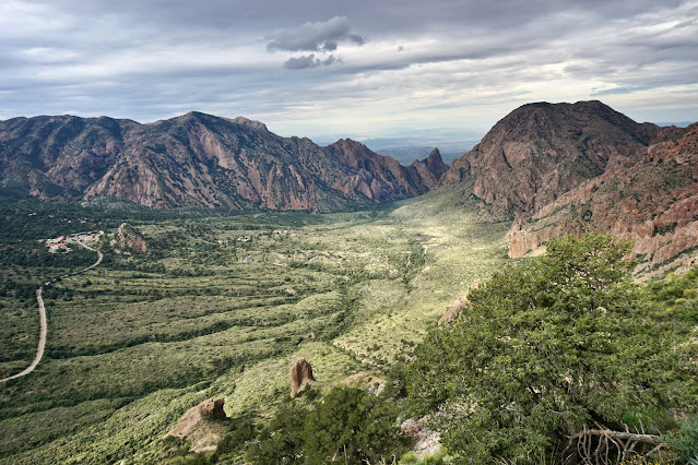
Soon, the surface is composed of more rock than plants and the going gets even easier. Stay right on top of the natural ridge. It doesn't take much elevation lift to see the entire Chisos Basin and out through The Window. Just west of the ridgeline curvature is an assemblage of weathered, welded tuff columns and pinnacles.
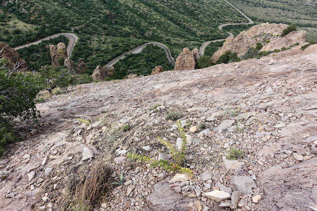
Just 0.3 mile into the hike, approach an extensive pink slab.
The bedrock sheet is composed of a volcanic extrusive granitic. There are plenty of features that assist with traction but make sure each footfall is solidly placed because there is some exposure...along with an equal amount of exhilaration.
Arrive on the tiny rounded crest of unranked Point 6,300' after just 0.4 mile of hiking and 580 feet of elevation gain. If you only have an hour to spare, turn around here after taking in expansive views of the Chisos Mountains. On our return, we walked out the east ridge a ways just for fun and spotted a fuzzy, thick-bodied brown and black desert tarantula.
For those going on to Mount Huffman take a moment to get oriented. Below, a false summit of Peak 6,905' is the tall prominence in the background. Mount Huffman stands in the sunny foreground. The Huffman Pinnacle is image-right. (THW, photo)
The hike described here is "just a walk." The Huffman Pinnacle is on a ridge flaring northeast. A cairn marked the start of the technical climb on friable rock. (THW, photo)
Descend the northwest ridge to the 6,140-foot saddle while threading through cactus. Natural rock pathways assist. We arrived in the saddle under a sodden sky.
Go right up and over the first knob you encounter. The rock is stable and wonderfully sticky underfoot.
My favorite segment of the hike was ascending a rounded rock rib. (THW, photo)
The upper ridge is effectively a linear Chisos Basin overlook. Carter Peak is the spire framing The Window on the south. Vernon Bailey Peak is the hulking mass northeast of the opening. (THW, photo)
The final length of spine is narrow and troubled with vegetation in all the wrong places. We diverted to the east where there's a bit of a natural passageway. Don't give up any more elevation than you must.
Reach the summit after just 0.7 mile of hiking. Easy and thrilling are not often paired making Mount Huffman both exceptional and sensational. Everywhere you look there are spikes and slivers of rocks, and skinny ridges made of fins. The topography is complex on all sides. The solitary summit boulder was stained white. There was no evidence of human visitation and we wondered if the aerie was the private domain of an eagle. (THW, photo)
Through splashes of sunlight we looked out over the higher peaks in the Chisos Mountains: Emory, Lost Mine, and Casa Grande. Below, the standing stones on the lower slopes of Peak 6,905' might well be called the Pulliam Pillars. Unnamed, the peak has a whopping rise of 1,125 feet. While it is higher than unranked Pulliam Peak and Bluff to its north, all three are incorporated into one massif.
Don't rush the return. Pirouette around the cactus and savor the short stroll down the stone rib.
Descending from Point 6,300', use caution near the top where loose material is concentrated. The pitch is just steep enough to be slippery.
Every mountain has its own origin story and unique characteristics--extending from its inner core to the surface where we walk. My interaction with each mountain varies, much like my response to the people I meet. There's something about this little mountain that infused me with happiness and a sense of renewal. I hope to return some day and get intimately acquainted with its neighbors.


No comments:
Post a Comment