Essence: Beauty accompanies every step toward this commanding Sky
Stone. Free climb for 2,000 feet on sheets and slabs of granite more typical
of the Sierra Nevada than the San Juan Mountains. This hike is best suited for experienced scramblers. LiDAR has increased the
elevation of San Miguel Peak to 13,756 feet with a rise of 1,314 feet, and a
Colorado prominence rank of 209.
Travel: San Miguel may be climbed from the Bandora Mine west of
Silverton, or the Lake Hope Trailhead north of Lizard Head Pass. Both options
are described.
Travel to the Bandora Mine Trailhead: From Silverton, drive north on US
550 for 2.0 miles. At the sign for the South Mineral Campground, bear left
onto a good dirt road. In 4.2 miles, pass the campground and continue for
another 2.5 miles on a slow, rocky, 4WD, high clearance road to the Bandora
Mine. Park on the right. Avoid continuing down to South Mineral Creek.
Travel to the Lake Hope Trailhead: First off, the Forest Service and
many other references call this the Hope Lake Trail. However, the lake is
correctly named Lake Hope on the topo. The turnoff from CO 145 to the
trailhead is on the north side of Lizard Head Pass at about mile marker 61.3.
Turn east onto CR 63A (to Trout Lake). After 1.5 miles, turn left on Hope Lake
Road, FSR 627. The trailhead is 2.5 miles up the rocky road. 4WD is
recommended but 2WD vehicles with good clearance and sturdy tires should make
the trailhead.
Distance and Elevation Gain from Bandora Mine: 10.2 miles, 4,650 feet
Distance and Elevation Gain from Lake Hope Trailhead: 8.0 miles, 3,250
feet
Total Time: 7:00 to 8:00 from Bandora; 6:00 to 7:00 from Lake Hope
Trailhead
Difficulty: Trail, off-trail; navigation considerable; Class 3 with minimal exposure
to the summit, Class 4 with considerable exposure to the optional subsidiary peaks
Map: Ophir, Colorado 7.5 USGS Quad
Latest Date Hiked: September 8, 2024
Quote:
In the mythic tradition the Mountain is the bond between Earth and Sky. Its
solitary summit reaches the sphere of eternity, and its base spreads out in
manifold foothills into the world of mortals. It is the way by which man can
raise himself to the divine and by which the divine can reveal itself to
man. Rene Daumal
A sunbeam spotlights San Miguel Peak as seen from the east ridge of Rolling Mountain.

Route: The Lake Hope Trail bears essentially south. At 11,640 feet, leave the lake trail and cut west on a social trail to the dam at the north end of the lake. From Bandora Mine, hike west to Hope Pass and descend to Lake Hope. At trail's end, climb over Point 12,047' and pitch down to the dam. Both routes join at the dam. Climb southwest staying south of San Miguel's northeast ridge. The most efficient route turns south at 12,760 feet and makes for a tarn at 12,900 feet. Pitch west to the southeast ridge of San Miguel, hitting it at about 13,500 feet. Climb northwest to the summit.


On two previous attempts I was turned back by deep snow in the upper basin. I tried too soon one year and too late another. This image was taken from Hope Pass, 12,445 feet, a good place to secure in your mind the true summit. On the right is a double-humped pair. San Miguel is the rounded summit on the left of the twosome. The flat-topped false summit on the right must be bypassed well below on the south. Many people have gotten in way over their heads climbing this scoundrel, especially in the treacherous notch below the actual peak. While it is possible to reach the crest that way, it is ill-advised for most hikers.

From the pass, give up 580 feet in 0.7 mile on an excellent, heavily trodden path to Lake Hope, 11,860 feet. In this image, the beguiling false summit is at the center. At the sign for Trout Lake, go left on a secondary trail. Just east of the lake is a 190 foot knoll. If you try to get around it at lake level, you'll get cliffed out. Climb over Point 12,047' and descend to the dam at 3.5 miles.

Route from Hope Lake Trailhead to Lake Hope Dam
From the trailhead at 10,720 feet, it is 2.4 miles with 1,220 feet of gain to
the Lake Hope dam. This popular trail is renowned for wildflowers. Initially,
the trail bears east and crosses the streamway in Poverty Gulch at 0.25 mile.
The creek gathers water from the west slopes of Pilot Knob, Golden Horn, and
Vermilion Peak and may be unsafe to ford in high water. Some of the hikers
seen below have over-shot the crossing.

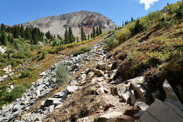
The trail turns south and holds the 10,800-foot contour while passing rivers of talus and old growth spruce with swooping trunks. Views of the San Miguel Mountains are captivating. Below, the intimidating northeast ridge of San Miguel Peak and Point 13,088' are glowing in morning light.

Lake Fork, the outlet stream from Lake Hope, and another pretty creek join
beside the trail at 1.2 miles. A series of switchbacks ascend in earnest to
timberline. Pictured is
Peak 13,302', climbed from Hope Pass or via a knife-edged ridge from Beattie Peak.
At 2.0 miles, 11,640 feet, leave the lake trail and cut west on a social trail for 0.3 mile to the Lake Hope dam. The trail is subtle and fragmentary but we were able to patch it together. Below, the markers are the lone spruce, the fin-shaped cairn, and the trail, image-lower-right. Stay below and north of Point 12,047', image-left.

Off-Trail Route to Summit
Both approaches discussed above meet at Lake Hope's outlet. It is not possible
to see San Miguel's summit from the lake. Between my partner and me, we have
been on half a dozen different routes from the lake to the summit. There's
plenty of freedom of movement but also some hazards best avoided. What follows
is our favorite and most efficient route. It is 1.6 miles from the dam to the
peak with 1,900 feet of vertical. First, cross the dam and climb the obvious
grass ramp.

These hikers are just above the ramp, ascending southwest. They are staying south of the northeast ridge of San Miguel. Yes, my partner did a successful climb to the peak on the northeast ridge but negotiating the notch is tedious and not at all fun.

Hold the southwest bearing to about 12,760 feet, thereby avoiding cliffs encircling the lake on the southwest.

It is steep but easy. Enjoy friction climbing on slabs and sheets of granite,
seeking out tundra runners.


At roughly 12,800 feet, turn south climbing slightly over 0.3 mile to a tarn
at 12,900 feet. Look into San Miguel's percolated waters. (C. Blackshear,
photo)

The southeast ridge of San Miguel is now in full view. The image below was taken from a higher location but it shows the rounded summit on the left, the notch on the northeast ridge, and the false summit seen from the lake, image-right. Looking at the southeast ridge from the tarn, there is an obvious notch just above the saddle (off-image on the left). Halfway between the notch and the summit is your best target for hitting the ridge. Pitch up due west from the tarn to 13,500 feet and then contour over to the ridge.

Use caution while traveling to the ridge. The slabs and boulders are gigantic
and some of them are teetering on the brink of taking out hikers. Stone
resting on the spine is more stable. However, there are a few obstacles to
intuit and finagle your way around. The summit is directly above this cluster
of people; a subsidiary peak is to the left.

The distinctive stone cube on the ridgeline signifies the summit nears.

The summit is surprisingly small for such a colossal structure. (THW, photo)

San Miguel can be seen from all over the San Juans so it follows that the view
from this vantage point is mind-numbing. Framing the expanse, not even two
miles south is colorful
Grizzly Peak, 13,738'.

At the center of this familiar cluster in the east is
Golden Horn
framed by U S Grant to its left, and
Vermilion Peak,
13,909' (LiDAR), on the right.

There are two subsidiary peaks adjacent to San Miguel tempting lovers of Class
4 rock. If the day has been too exposure-free, here is your fix. But don't go
over because you are not sure which peak is highest. Trust me, the one you are
standing on is the legitimate high point. Climb the easier peak on the right
to get warmed up, walking gingerly on the knife.

On the way back, climb down into the notch and scale the Class 4 tower due
west of San Miguel. Face to the rock, my pigtails kept obscuring my field of
vision! Downclimb facing the rock. (C. Blackshear, photo)

Retrace your steps back to periwinkle blue Lake Hope. Those returning to
Bandora must reclimb Point 12,047' (190 feet) and recover the 580 feet to Hope
Pass. For those returning to the Lake Hope Trailhead, there's roughly 100 feet
of gentle ascent in the woods. (THW, photo)

In September, 2012, a massive moose grazed slopes west of the lake. (Betsey
Butler, photo)

For those returning to Lake Hope Trailhead, the north flanks of San Miguel
bear the eternal gift of the ephemeral flower. Below, Lizard Head
communes with rosy paintbrush.

3 comments:
Lovely hike; thanks so much for the great directions. Only saw one other group of hikers above the dam, despite steady stream of people encountered on the way back down from Hope Lake.
How would it be in late February? Like 27th? Is there snow? Is it safe?
According to Colorado SNOTEL the snowpack on Lizard Head Pass is 41 inches on January 15, 2023. Currently, it is snowing. Snow accumulation on San Miguel will be significantly higher. The Colorado Avalanche Information Center rates the avalanche danger "Considerable." I suggest waiting until July to tackle this high 13er. Debra
Post a Comment