Travel: From Durango, drive north on US 550 about 47 miles to Silverton. Continue north toward Ouray for two miles. At the sign for South Mineral Campground, bear left onto a good dirt road. In 4.2 miles, park on the right at the trailhead. Allow 1:15 from Durango.
Distance and Elevation Gain: 12 miles, 4,200 feet of climbing
Time: 6:30 to 8:00
Difficulty: Trail, off-trail; navigation moderate; some Class 3 scrambling and exposure on the summit block.
Map: Ophir, Colorado 7.5' USGS Quad
Latest Date Hiked: August 31, 2019
Quote: The unexpected and the incredible belong in this world. Only then is life whole. C. G. Jung
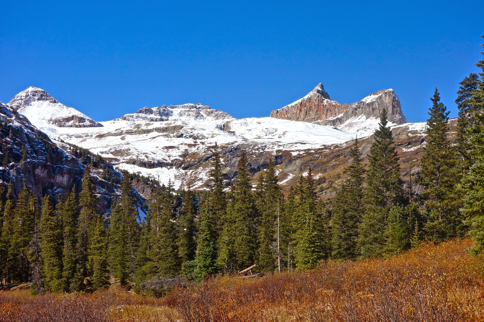
From Golden Horn, Ice Lake is 1,500 feet below. Two friends adorn its twin-like subsidiary peak. (EJB, photo)

Route: From Ice Lake Trailhead, elevation 9,840 feet, take the standard trail to Ice Lake. Continue on a secondary trail toward Fuller Lake. Ascend onto the bench north of the lake and utilize it to gain the Fuller/Vermilion/Golden Horn basin. Climb northwest to the Vermilion-Golden Horn saddle and then northeast to the peak.

The trek to Golden Horn makes pleasant use of the Ice Lake trail, switchbacking lazily up through a subalpine forest of conifer and aspen.

Flowers are abundant and occasionally unusual: Star Gentian and Fringed Grass of Parnassus. (THW, photo)

After 2.2 miles, at 11,460 feet, break out of the trees at the unsigned turnoff for Island Lake. While climbers will continue straight, the junction does afford the first view of the unmistakable Golden Horn, shown below. Indomitable Vermilion Peak, 13,894', image center, is the highest mountain framing the basin. While Vermilion is a challenging Class 3 climb, Fuller Peak, 13,761', the perfect pyramid at left, is the easiest to achieve of the three.

There is typically a two month window for climbing Golden Horn, from early August until the snow flies. Snow lingers deep and late in the upper basin, confined beneath the highest mountains. In the lower basin the outlet streams for Island Lake and then Ice Lake must be forded. The latter can be a boot soaker. If there is time and energy on the return the Ice Lake cascade provides an astonishing exploration option. (THW, photo)

Exit the lower basin on a thin, rocky trail, climbing 740 feet in the final mile to Ice Lake, 12,257 feet. Reach it at 3.6 miles. Profound color saturates your experience of this place.
Colors are the deeds and suffering of light. Goethe

From the shore, the bulky stanchion of Golden Horn's northeast ridge, Point 13,230', obscures its delicate spire. Climbers must skirt this ridge on the left. The easiest way is by use of a bench located between the ridge and Fuller Lake.

Keeping Ice Lake on your right, follow the Fuller Lake trail southwest. Pass a shallow lake whose reflective mirror is pleasingly broken by boulders at 3.8 miles.

Continue up the trail and Golden Horn comes into view.

Cross Fuller Lake's outlet at 4.1 miles and then look for any plausible route onto the bench, about 200 feet up on the right, shown. A social trail and cairns assist the trek across the bench moving southwest.

Visually locate the saddle between Vermilion and Golden Horn, image-right. Follow cairns off the bench at about 12,960 feet to the right/west. Cross the high basin on broken rock void of plant life.

The scrabbly 300 foot climb to the saddle is riddled with short cliffs but you can wiggle your way up through the rock. In fact, there are fragments of social trail that zigzag to Saddle 13,380'. The best track is within the rock trending near the left side. In the image below, climbers are half way up the pitch.

The peak is 400 feet above and 0.3 mile away. In this image, a climber stands on the summit.

The climb begins on loose, gravely soil but quickly becomes a four-point scramble with some exposure on debris-compromised rock. Stay on the craggy ridge as long as possible. The standard route favors the right/east side on slippery soil, shown below. It moves left into a pronounced gap between the two summit spires. I prefer to stay right on the ridge all the way to the spire. (THW, photo)

It is an unexpected delight to discover Golden Horn has two summit pinnacles, double the pleasure. Start with the highpoint which is on climber's left, facing the mountain. The stair-step scramble to the zenith is easier than the approach. Vermilion Peak is image-left. (THW, photo)

The tiny tipped, 4 X 4 foot horn has room for a small cluster of people. Be steady; it is exposed and airy up there.
(THW, photo)

From the summit spire, study the subsidiary block and plot your route. Choose between a couple of slits. (THW, photo)

For the return, I retrace my steps. However, once I saw a man clamber off Golden Horn and do a pure ridge traverse to Pt. 13,230'. He dropped into the basin between Golden Horn and Pilot Knob and re-emerged at Ice Lake.
It is possible to do a gnarly ridge climb from Golden Horn to Vermilion. Or, traverse below the ridge on a bench and arrive not far below the Vermilion-Fuller saddle. I have not done either of these nonconventional routes.
Vermilion and Fuller are typically climbed as a pair from their shared saddle. Once, while standing on the apex of Golden Horn, I waved to some friends on Vermilion. They later referred to Golden Horn as the "Headline-Grabbing Peak."
Ice Lake Basin is a gathering place for drenching rain, hail, sleet, snow, and electricity so start early on a reasonable weather day.
4 comments:
The last shot on the golden horn has is one of my favourite photographs. Just absolutely stunning.
Thank you. Golden Horn is one of my favorite peaks in Colorado with its twin summits of weathered stone overlooking wildly blue lakes.
Is there a way to get your gpx for the hike. Much easier for me with a file. Your route looks great.
You can do it! Let the landscape guide you. My GPX file might just confuse you because I wander all over the place. The maps on my posts are cleaned up versions of my routes. You are going to love this climb!
Post a Comment