Essence: The Henry Mountains are a 56 mile-long chain of five high peaks in remote terrain in south-central Utah. Mount Hillers, also known as Middle Mountain, is located between Mount Ellen and Mount Pennell to the north and Mount Holmes and Mount Ellsworth to the south (the Little Rockies). All five are on the Utah Top 100 Prominence List. Mount Hillers is a big spectacular mountain with a rise of 3,357 feet. LiDAR increased the elevation noted on the Cass Creek Peak quad by five feet to 10,742 feet. The summit ridge is airy and the zenith is in an exceptional position for viewing all of the peaks in the range and into
the large-caliber West. Its perspective on the Waterpocket Fold is unparalleled. The off-trail climb is demanding but worth every ounce of effort. The north ridge is ultra steep with loose material rolling out from underfoot. The hike is on public land administered by the Bureau of Land Management.
Travel: From Hanksville, drive 26 miles south on UT 95. At mile marker 26, turn right on UT 276 toward Ticaboo. Turn right just beyond mile marker 17 (17 miles down the road) at the sign for Starr Springs Recreation Site. At 3.2 miles, the road to the Starr Springs Campground branches to the right. For Hillers, turn left and measure distance from there. The road is well graded but rocky as it swings around the south and then the west flanks of Hillers with plenty of dispersed camping. It is 2WD passable with sturdy tires. At 1.8 miles, turn right on BLM 13500 toward Stanton Pass. Stay on the main road as it climbs and descends, steeply at times. It goes in and out of many ravines. At 10.4 miles, stay straight toward Stanton Pass when a road forks left toward The Horn and Straight Creek Junction. Park off the road at 10.6 miles across from signed BLM 13530. There is no formal pullout. It took us 50 minutes from Starr Springs Campground. Your mileage will likely vary.
Camping: Starr Springs Campground has 12 sites (no reservations), water (2024), cottonwood
shade, stellar views of the Little Rockies, fire pits, tables, pit
toilets, fee, carry out your trash.
Geology: The concept of a laccolith was developed in the Henry Mountains by G.K.
Gilbert in 1877. For more information on the Earth's mountain-building power specific to Mount Hillers, please consult Written in Stone and In the Company of Plants and Rocks.
Distance and Elevation Gain: 6.0 miles; 3,600 feet
Total Time: 5:30 to 7:30
Difficulty: 4WD track, primarily off-trail; navigation moderate; Class 2, ultra steep slopes with loose rocks; no exposure; brushy, wear long pants; ephemeral stream flow--carry all the water you will need.
Map: Cass Creek Peak, UT 7.5' USGS Quad
Date Hiked: June 4, 2024
Quote: Geology is all around us, scarcely thought of as we go about our lives. Yet, it affects everything we do as a civilization, as a society and as individuals. While barely appearing to change from day to day, it works to alter the course of evolution. Preserving a record of creatures and landscapes both ancient and forgotten, the story of our past is written in stone and waiting to be read. Jack Share
A mountain of igneous intrusives thrusts from the soft red forms in the surrounding desert. The south face of Mount Hillers is ringed by a zone of shattered and uplifted sandstone. Alternatively called flanks, spurs, and base crags, color variation correlates with the geological era exposed in the contact zone.

Mount Hillers was named for J. K. Hillers, a photographer with the 1871 John Wesley Powell Colorado River Survey. All the major peaks in the Henry Mountains are visible from UT 276. They startle in their profound contrast with surrounding sage flats, red
sand, and thin, deep canyons cleaved into slickrock. 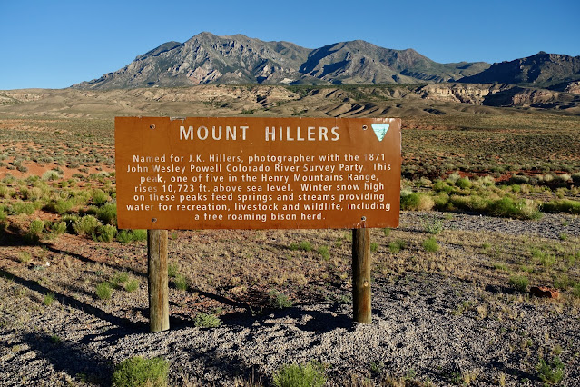
Route: There are different approaches to Mount Hillers. The standard route starts off on a primitive, intermittent, technical 4WD road bearing east beside Cass Creek. Gaining the north ridge is the only navigation conundrum. The blue-line route is the most direct. (We have not been on that route.) Or, ascend to the Cass Creek Peak--Mount Hillers saddle and make your way south-southwest to the north ridge from there. Hike south, climbing steeply over two numbered points to the summit ridge of Mount Hillers and walk east to the peak.

From parking, elevation 7,300 feet, hike east on BLM 13530. Theoretically, the primitive road is open to vehicles and we saw OHV tracks for the first half mile on the rocky road.

Aromatic lupine was blooming in the center and on both sides of the track. We saw a few scattered flowers in blossom: brilliant red Indian paintbrush, royal blue flax, orange globemallow, scarlet gilia, evening primrose, and yarrow. In June of 2003, the Bulldog Fire consumed 34,000 acres of habitat in the Henry Mountains. In the lower elevations the piñon-juniper woodland was torched.

The route passes to the south of Cass Creek Peak, 9,428 feet. It is a captivating mountain with an igneous flank protruding from the massive talus pile. (Thomas Holt Ward, photo)

At 0.7 mile the roadbed was obliterated by Cass Creek and we wandered around trying to find it. The terrain was friendly enough and we just kept bearing east toward the saddle.

At 1.0 mile, 8,000 feet, a remnant of the abandoned road reappeared on the south side of Cass Creek. We rose into the aspen zone at 8,100 feet. Normally, these trembling beauties make my heart sing but the post-fire opportunists became so thick, eventually they ran interference. Over the years as they grow they may get even more laborious for the hiker. We climbed over and ducked under considerable conifer deadfall. The forest must have been incredibly beautiful before the fire.

There was no way we were going to shortcut shy of the saddle. But if you'd like to take the most efficient route to the north ridge proper, consider leaving the road at about 8,400 feet and ascend southeast, shown.

The road completely disintegrates as it closes in on the saddle, 1.6 miles, elevation 8,580 feet. If you wish to add Cass Creek Peak, it is an 848-foot climb. The image below shows the lower mountain from the saddle.

Mount Hillers has two north flowing ridges that terminate in the saddle, shown. It appears that either ridge can be mounted to the peak. However, the standard route is on the ridge further west, image-right, confirmed by periodic cairns. No matter how you work it, getting onto the north ridge is a demanding challenge. From the saddle to the summit the terrain is consistently steep and loose. We started out on an abandoned road, climbing over deadfall, aiming for Cass Creek that runs down the ravine between the two north ridges. The stream was flowing strong and it took some care to find a suitable path into and out of the trench. (THW, photo)

We bashed through deadfall and aspen and were relieved to move out onto a super steep, unencumbered talus slope. (THW, photo)

We worked southwest over to the ridgeline, reaching it at 1.9 miles, 8,900 feet. Notice the double-trunk standing dead in the photo below. (It may be on the ground when you hike!) This is where the blue-line route and our route from the saddle came together. We do not recommend our descent route, also shown on the map above. It departed from there as well but we were entangled in brush as we headed down the hill.

We anticipated a social trail on the ridgetop but there was none, not even any footprints. The ridge was slightly less steep than the approach as we mounted blocky Point 9,162' at 2.0 miles.
Looking back, Mount Pennell and Bull Mountain (now that's a seriously difficult climb) are rippling off north of Cass Creek Peak.

Looking ahead, two distinct rollers precede the summit.
We walked by a gnarled tree communing with stone on the south side of Point 9,162'.

The second knob has an orange top and an intriguing blob of dark gray stone. We saw mountain lion prints pressed into the soil in that area. We saw plenty of mule deer tracks but in all our hiking in the Henry Mountains we've never seen evidence of the "free-roaming" American bison herd.

Below, I'm not positive if this is shale or metamorphosed slate. I find it intriguing that the colorful extrusion is exposed so high on the mountain. Apparently the sedimentary overburden was not entirely removed here as the laccolith upthrust.

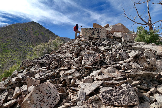
A fractured wall of igneous stone precedes the top of the second roller at 9,380 feet.

Large plates of talus clinked underfoot. This pleasant interlude was over way too soon.

We caught a glimpse of our vehicle 2,000 feet below. It's hard to believe you can so quickly achieve these distances and vertical gain by foot power.

A half dozen very old substantial cairns on the ridgeline signaled we were on the standard route. I can't say they were necessary, but they were reassuring. (THW, photo)

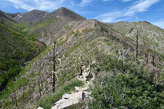
Two decades post fire, incinerated trees were still stately standing. Common species in the Henry Mountains include Douglas fir, spruce, ponderosa pine, limber pine, and aspen. Bristlecone, members of the white pine family, are less common.

The grade steepened as we approached the top of the third roller. Climb almost 900 feet in 0.5 mile. Rocks rolled underfoot and it was hard not to slide backwards. Every step had to be monitored. I love this mountain because of where it sits in the western landscape but it is not an easy trek for the hiker. (THW, photo)

Crest a false knob and continue climbing. (THW, photo)

Round Point 10,295' at 2.7 miles. The summit was in sight, the pitch decidedly more forgiving. Give up 60 feet. The hillside was covered in aspen living in the krummholz zone. Their little white trunks were stunted and twisted from wind and snow.

The climb finishes on a somewhat narrow summit ridge. It's so airy you'll know you are on the peak when you're climbing the last few feet. Even the rocks are different, a light gray diorite.

Crest Mount Hillers at 3.1 miles. The small stone summit enhances the view into "the measureless reaches of the West" (Clarence Dutton, geologist). This has to be the best possible perspective on the Waterpocket Fold. See its 100-mile-long extent and true nature in Capitol Reef National Park west of the Henry Basin Badlands. There were two notebooks in the peak register. The oldest was placed in 1992. The second was placed by the Los Angeles Chapter of the Desert Peaks Section of the Sierra Club in 2003. We were the third party to sign in 2024. (THW, photo)

The La Sal and Abajo mountains were visible to the east. Point 10,578' on the southeast ridge pointed toward Mount Holmes and Mount Ellsworth in the Little Rockies. Catch a glimpse of the Colorado River.

Look over Point 10,413' on the south ridge to Navajo Mountain (another laccolith!) and the Straight Cliffs around the margin of the Kaiparowits Plateau.

Northward, the three ranked summits of Mount Ellen are visible. They may be higher but Mount Hillers is most definitely the tougher climb.

No comments:
Post a Comment