Essence: Bull Mountain is a ribbed hyperbola with a rise of 1,367 feet northeast of the Mount Ellen group. The alluring peak looks spectacular from all vantage points. The off-trail climb is brushy, short and steep. Talus and scree poised at the angle of repose present a hazard to climbers. Avoid with groups. The peak is within the Bull Mountain Wilderness Study Area administered by the BLM.
Travel: From Hanksville, drive south on UT 95 and turn right on BLM 0095 (3150 East) at mile marker 9.9. The road to Granite Ranch branches left at 2.6 miles. Take the right fork toward Lonesome Beaver Campground, staying on BLM 0095, also Fairview Ranch Road. The road ends at Fairview Ranch and a T intersection at 6.0 miles. Turn left on BLM 0096, also Sawmill Basin Road. As the road climbs toward the mountain it gets increasingly rough with cobbles. Park off the east side of the road at 11.7 miles (Point 7,330'). 2WD with sturdy tires and good clearance should suffice.
Distance and Elevation Gain: 2.5 miles; 1,960 feet of climbing Total Time: 3:30 to 5:00
Difficulty: off-trail; navigation challenging; ultra steep and loose Class 2; brushy, wear long pants; trekking poles helpful for powering up and plunging down scree slides; hike on a cool day and carry all the water you will need.
Map: Bull Mountain, Utah 7.5' USGS Quad
Date Hiked: June 5, 2021
Quote: We cannot solve problems by using the same kind of thinking we used when we created them.
Albert Einstein
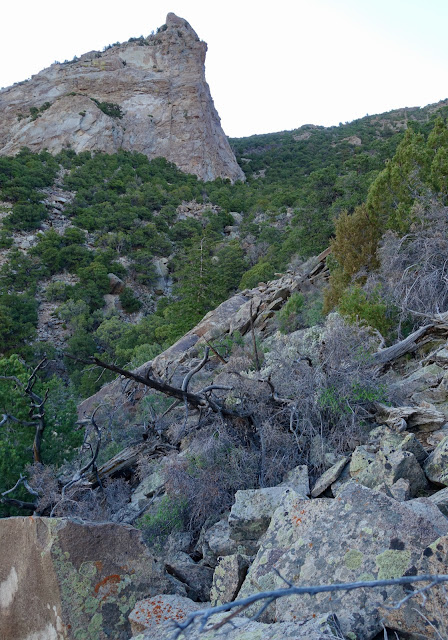
Exposed igneous ribs encircling Bull Mountain are accentuated in dawn light.


The stone ridge above the dome looked appealing so we topped it at 8,140 feet and worked the south side for 300 feet dodging gendarmes. It was a pleasant interlude. We headed back into the swale when the ridge cliffed out.


Route: There are multiple approaches to the summit from the west side and your route will likely vary. We referenced the GPX track of a friend but continuously tweaked it to get ourselves out of trouble. From the parking area, we climbed east on the black-line route. The blue-line descent route takes advantage of scree slides.

We began the hike in the cool hours of the morning and were grateful to be shaded by the mountain. It was 88 degrees when we got back to the car well before noon. From the parking platform, elevation 7,300 feet, analyze your approach. I'll describe our route but there is flexibility to create your own experience. Comments welcome. Looking at the center of the image below, we ascended between the horned rib on the left and the domed rib on the right. We descended to the right (south) of the domed rib to take advantage of scree slides. (Thomas Holt Ward, photo)

Pass by the weathered cone block that served as a landscape marker on our return. It is the first of a series of massive blocks composed of an intrusive igneous granitic, likely porphyritic diorite. In 1877, G. K. Gilbert developed the term "laccolith" to describe the characteristic shapes of the igneous intrusions that core the Henry Mountains. For a more detailed discussion of the geology of the range, see the Mount Ellsworth post.
On the lower mountain it was easy enough to weave around the vegetation--buffaloberry and ephedra provide cover in the mature piñon-juniper woodland. The chipped rock surface made for good footing to begin. As the slope steepened, big boulders became rock puzzlers; trees provided welcome security. There is an ever-present danger of dislodging boulders and rolling them down on your hiking buddy. At 7,850 feet, we were right under the domed rib and were slabbed out.

We did a rising traverse across a talus jumble, shown, working northeast toward the gully in the center of the swale, but not in it. The closer you are to the gully, the steeper it gets.

The stone ridge above the dome looked appealing so we topped it at 8,140 feet and worked the south side for 300 feet dodging gendarmes. It was a pleasant interlude. We headed back into the swale when the ridge cliffed out.

The image below was shot from the north side of the domed rib. From here, it is probably best to aim for the saddle south of Point 9,094', image-left.

We encountered a swath of fine-gravelly scree. The escalator slope was impossible to ascend so we did a lateral toward the horned rib until we were back on talus. The incline pitched more radically on the headwall. Personal note: This mountain worked my mettle, not physically, but mentally. It was frightening to have boulders constantly sliding out from underfoot. However, the climb didn't phase a couple of friends who charged up a few weeks prior. (THW, photo)

Bathed in early light, the four horns on the stone rib radiate power.

The last 100 feet to the north ridge graduated to a more reasonable pitch. We reached the 9,000 foot saddle at one mile. Heading south, rock outcrops have weathered into stacked horizontal slabs.

We crested Bull Mountain at 1.25 miles after 2:15 hours of climbing. (Yes!) It did not possess the dramatic summit we anticipated but there was a cluster of accommodating sitting boulders. The peak register recorded an average of four parties a year. The previous entry was from a Salt Lake City physician who wrote, "THAT was a Bitchathon!" My partner reflected, "If someone asked me about climbing I'd say if you really want to get it sure, but you're just going to be bashing through trees and sliding all over the hillside with rocks rolling all over the place and wishing you were somewhere else."

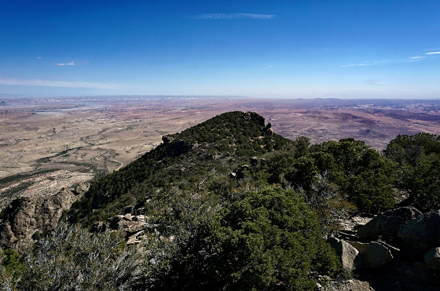
The full-compass view is phenomenal. The south face is a mass of chaos and crags. Splayed out across the horizon are challenging Mount Holmes and Mount Ellsworth in the Little Rockies, image-left, the most southerly sector in the Henry Mountains. Moving right are mounts Hillers and Pennell. (THW, photo)

In the west are South Summit Ridge Peak, Mount Ellen, and Mount Ellen Peak. Mount Ellen, the high point of the Henry Mountains, is ranked number 29 among the 57, P1500 summits in the Lower 48 with 5,862 feet of prominence. Smaller in stature, Bull Mountain nevertheless presents a much higher order of difficulty.

Fairview Ranch is visible on the tableland to the left of deep green Point 9,094'. (THW, photo)

This image was shot from the summit where we plotted our 1.5 hour descent route. We left the north ridge before the saddle searching out scree slides. The cone boulder at the parking area is visible below. (THW, photo)

At 8,600 feet we made fast progress on the upper scree slide. It was fun but a little disconcerting to be in the company of large boulders coming right along for the ride.

We aimed for a familiar gendarme on the domed rib and stayed with the ridge until we reached the topside of the dome at 8,100 feet. We turned south to plunge down a series of slides. We happened upon massive flakes of exfoliated rock, one of the best features of the hike. Then we held a northwest bearing back to the parking platform.

You'd like to go for a ride? The raging bull is best suited for the nimble, strong, and courageous climber.

No comments:
Post a Comment