Travel to Columbus Basin Trailhead: In a 4WD vehicle with good clearance and sturdy tires, from the US 160/550 intersection in Durango travel 11.0 miles west on US 160 to Hesperus. Turn north on La Plata Canyon Road, CR 124, and measure from here. After passing the hamlet of Mayday the road turns to smooth dirt at 4.6 miles. There are several established campgrounds in this area. In 8.5 miles the roadbed deteriorates. At 12.1 miles the road splits. Turn right on FSR 498, the track to Columbus Basin. (For the Kennebec Pass Trailhead proceed straight on FSR 571 for 2.1 miles.) The road is steep and the rocks are sharp. Drive for 0.9 mile and park in a wide pullout on the left. A distinctive fallen log cabin is on the right.
Distance and Elevation Gain: 5.8 miles with 3,000 feet of climbing for both mountains. Lewis Mountain alone is 4.6 miles with 2,300 feet of vertical.
Time: 5:00 to 7:00
Difficulty: Forest Service road, old burro trail, mostly off-trail; moderate navigation; consistently moderate exposure with considerable exposure on low Class 3 knife sections.
Map: La Plata, Colo. 7.5' USGS Quad
Latest Date Hiked: August 18, 2019
Quote: As the hand held before the eye conceals the greatest mountain, so the little earthly life hides from the glance the enormous lights and mysteries of which the world is full, and he who can draw it away from before his eyes, as one draws away a hand, beholds the great shining of the inner worlds. Rabbi Nachmann
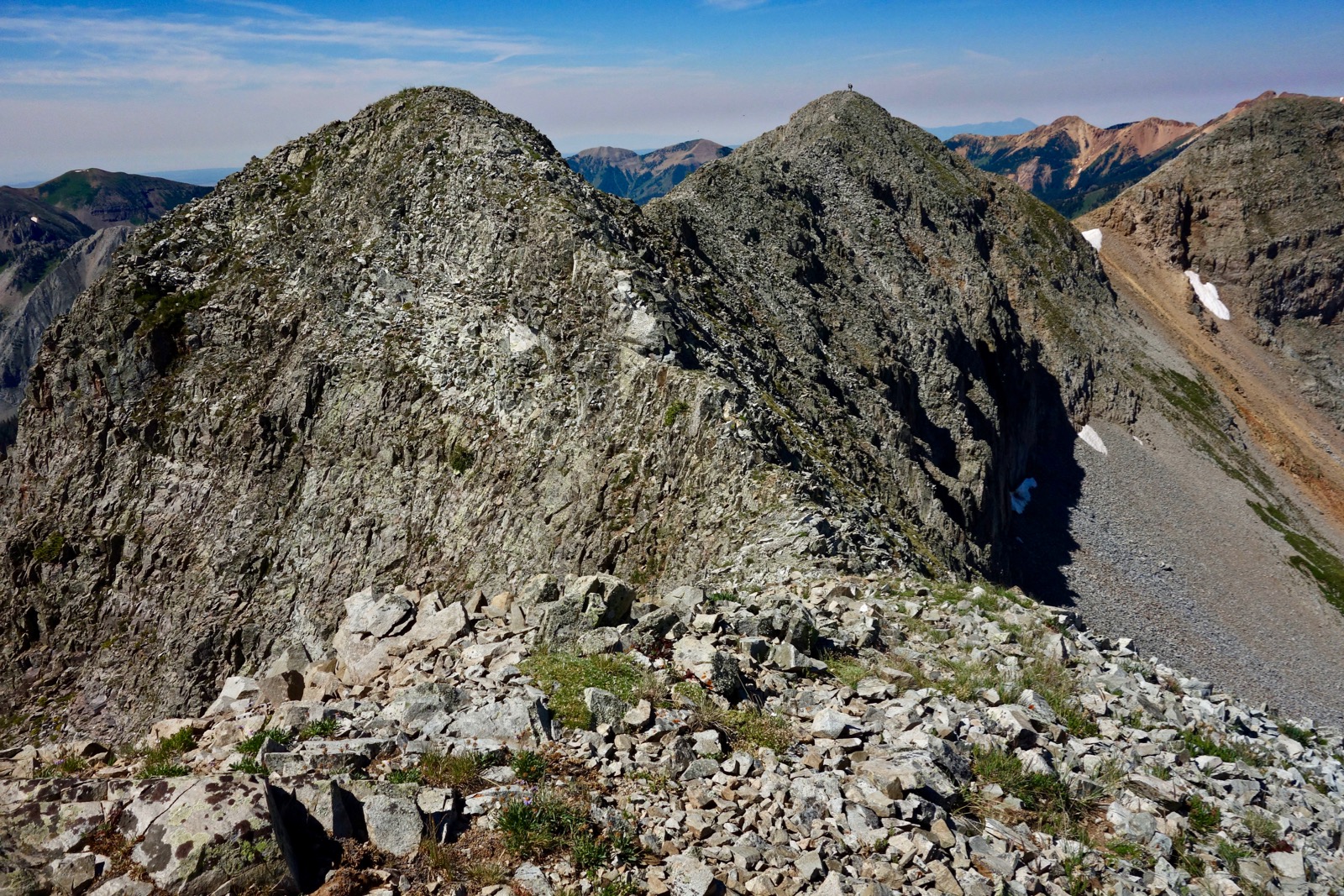
The mystique of Lewis Mountain is simple. It is not what it appears. Viewed from College Rim, the bastion (right of image-center) looks robust, bulky, and alluring. Its steady presence presides over Durango.

In reality, the mountain takes the shape of a loosely draped necklace. All along the thin thread are numerous steep-sided prominences. This image was shot from the south ridge of Snowstorm Peak, an extension of Lewis Mountain ridge.

Route: After trying several approaches and iterations on the Snowstorm-Lewis ridge, the black-line route is my favorite. Alternative routes are discussed at the end of this post. From the parking pullout ascend on FSR 498 as it switchbacks into the upper basin. Segue onto a trail that climbs northeast to the pass at 12,180 feet. Walk north to collect Snowstorm Peak, return to the pass and traverse south, then west, and finally northwest in a mighty arc. Leave the ridge once you are well into the trees and bear east back to the start.

From the Columbus Basin Trailhead, elevation 10,980 feet, walk south on FSR 498. The road gains elevation consistently and pleasantly. The major switchback at 0.3 mile might dissuade you but the rarely traveled road is an efficient path. You certainly could walk up through the basin but it takes longer. This image of the log cabin and parking was taken on our return.

It is a little tricky transitioning to the pass trail and staying on it. To help navigate, this image was taken from the northwest ridge of Lewis Mountain. You will be walking up the road that is on the lower left. The road swings east and crosses the outlet of the small lake that sits high on a hill, shown. The trail begins soon after this crossing and wanders up the hill. If you lose the path (likely) look for it as you top the hill to the north of the lake. Notice the trail making a rising traverse to the north across a scree slope. It then switchbacks up the headwall to the pass. Snowstorm Peak is far left. (Thomas Holt Ward, photo)

Note: In 2005, I climbed to the northwest ridge of Lewis starting in the vicinity of the second switchback. It was fiercely steep on resistant soil with debris at the angle of repose. After circling over Lewis and climbing Snowstorm we retreated to the saddle south of the "Red Ball." We then plunged down to the abandoned road on the east side of the basin, not a repeat route. To complicate matters, we had two big dogs with us who needed a lot of assistance, including hefting, to complete the circuit.
Runners: This trail is integral to Durango's annual Kennebec Mountain Run. The footrace race begins in La Plata City, ascends on CR 124 and FSR 571 to the Kennebec Pass Trailhead, goes through The Notch and along the east side of the ridge past the Bessie G Mine. Then runners take the burro trail to the pass, descend through Columbus Basin, and return to the start.
This image was taken into the sun but it attempts to show the trail leaving the road and the switchbacks to the pass, image-left. Crest the pass at 1.8 miles, elevation 12,180 feet. This also happens to be the low point between the two mountains.

Snowstorm Peak, 12,511'
The spur to Snowstorm is 1.2 miles roundtrip with 700 feet of climbing. The walk is pretty tame with just one short narrow stretch. There are six knobs on the ridge. One rocky outcrop may be easily flanked near the crest on the east side. The Red Ball, Point 12,420', is a false summit. Snowstorm is an excellent vantage point. On a clear day even Lone Cone, the westernmost peak in the San Juan Mountains, is visible.

Lewis Mountain, 12,740'
Return to the pass at 3.0 miles, shown. It is one mile to the Lewis Mountain summit, image-center. Once I counted 12 serrations and yet the ridge is surprisingly free of obstacles. There are a couple you may wish to bypass. Once, while working around a lofty gendarme my hold pulled off the mountain. Test everything.

If you are not comfortable with what you see heading south, turn back. Since my previous visit a fragmentary wildcat trail had developed. It made easy work of the second crest, shown. Note two other hikers out in front of us.

Half a mile from the pass the first and longest section of knife commences.

"The Blade" is the first obstacle. Some people straddle the rock's spine. There is a small ledge on the west side with decent footing. The hand holds vary in dependability so be methodical.

Below, I have come around The Blade. (THW, photo)

The second knife leads to a crest at the apex of the arc, shown. On the La Plata Quad this prominence ranks equal with the summit. But when you get out there, the true zenith is clearly the one with a south ridge pitching down to Eagle Pass. Below, two figures are standing on top. The map does not note or number the highpoint of Lewis Mountain so the exact height is unknown.
The third knife leads to the summit at 3.9 miles. The mountain presents a full-circle viewpoint. Look out over Durango, Lake Nighthorse, companion peaks east of the La Plata River and those across the waterway on the West Block: Parrott Peak to Sharkstooth Peak. Indian Trail Ridge points to the greater San Juan Mountains: the San Miguel Mountains, Mount Sneffels Wilderness, and the Grenadier Range and Needle Mountains in the Weminuche Wilderness.

Return to Columbus Basin
The next series of serrations add up to 300 feet of elevation gain while descending the northwest ridge. The challenge decreases. One friend said this segment is super fun; another said it is one of the most beautiful strolls. But it remains airy so don't let your guard down. First, climb the banded prominence with the broad, flat top. The ridge dives. Ahead is Tomahawk Basin ringed by the three Babcock Peaks, Mount Moss, and Diorite Peak. Centennial Peak is close by to the north.

In mid-August, Arctic gentian were blossoming on the ridgecrest. (THW, photo)

The final push is a steep 230 foot climb to Point 12,530'.

Below, I am standing on the next knob with Lone Cone to my left. (THW, photo)

The last roller has big beautiful blocks with dotted saxifrage growing in crevices. The road and switchback are location indicators.

Stay on the narrow ridge as it goes into the trees at 11,800 feet.

While it is tempting to start the eastward plunge anywhere along here, there is a lot of cliff structure. The ridge broadens as it swings southwest at 11,600 feet. Initiate the drop where you wish. A social trail leaves the ridge making for a bench below. That works. We lingered looking for the golden path and found it. We started rolling off the ridge at 5.35 miles. We hit a big flat and then stuck to gentle slopes pointing east all the way to the road. It was a floriferous year and we waded through Grey’s angelica, monkshood, osha, corn husk lily, bluebell, American bistort, king's crown, arrowleaf senecio, orange sneezeweed, little sunflower, death camas, rosy paintbrush, elephant head, and columbine.

Alternative Routes: Kennebec Pass Trailhead to Snowstorm Peak via Northeast Ridge
This is the blue-line route on the map above. Park in a large lot that serves the Colorado Trail. Snowstorm is 1.5 miles south with 1,000 feet of vertical. From the trailhead, elevation 11,620 feet, walk southeast on an old mining road that still carries occasional 4WD traffic. Curve under the west slopes of Cumberland Mountain and go through The Notch, an obvious blown out feature. The image below shows The Notch and the northeast ridge, a quick but not trivial climb.

After passing through The Notch at 12,000 feet continue on the road until you are past the short razor-topped ridge. Initiate the climb. You will have to move a little east to get around some cliffs before returning to the ridge. If you don't like the looks of the ridge, you have two choices. You can climb the ultra steep east slope of the mountain, shown, or take the red-line route to the Bessie G Mine.

This image was shot from Snowstorm Peak. It looks down on the northeast ridge, the razorback remnant, and the road flanking Cumberland Mountain.

Kennebec Pass to Pass 12,180' via Bessie G Mine
This is the red-line route on the map above. It is about two miles with 950 feet of climbing. Walk through The Notch and continue on the degenerating track for another half mile. The road becomes a trail after passing the mine. The footpath mounts an eastward ridge and then climbs the north side of Ruby Gulch to the pass. The image below was shot from the Lewis Mountain ridge looking back at the trail coming up from the Bessie G to the pass.

Lewis Mountain from Eagle Pass
If your objective is to simply summit Lewis Mountain, take the purple-line route on the map above. Drive up La Plata Canyon Road for 9.4 miles and park at Lewis Creek Road. Or, turn right onto CR 124 A and go up the 4WD road, paralleling Lewis Creek on the north for three miles. The track is steep, rugged, and rocky throughout. Turn-around parking is at elevation 11,360 feet. From the upper parking the summit of Lewis Mountain is 1.1 miles with 1,400 feet of climbing.
I have not taken this route but I know plenty of people who have. The image below was snapped from Eagle Pass on a day I was climbing Bald Knob. Please link to that post for a description of the beautiful walk to Eagle Pass. Then climb north on the ridge which culminates directly on the highpoint of Lewis Mountain.

Snowstorm Peak and Lewis Mountain commingle to create the longest, continuous ridge hike in the La Plata range. There is a sense that the entire spine is the summit, from its thin beginning just above The Notch, swinging around in a great arc, gathering Snowstorm, encompassing Lewis Mountain, and refusing to terminate until it dissipates in the waters of the La Plata River. It is a rim that demands the traveler's unbroken mindfulness. The serrated precipice affords a new perspective on one's inner world and the great circle of the horizon.
Lewis Mountain from Smelter Mountain, February, 2014.

9 comments:
Thank you for your help. Is there a way to access the ridge without venturing onto the knife edge ridge?
On Debra's behalf: I'm afraid not. This one is probably best for those that are seeking a little extra thrill from their ridges. Tomas.
Re the Bessie G mine: There is a small short cut trail to the ridge just above the switchback that leads to the mine. If you look down as you descend from the Notch, you will see an old Ford Bronco on the road before the mine. The most direct route is just before that Bronco. It ascends directly to the ridge and onto the trail near the top of Ruby Gulch.
Thanks for your helpful comment, Brett. Debra
I climbed Lewis in 2022 using the standard route across the ridge. After summit, we continued around ridge for more fun. It still had some exposure, but nothing like the knife edge. There was a very obvious trail too.
After traversing 2 humps west of the peak, we dropped down into a saddle at about 12,300 and decided to call it the day and went straight down a drainage to the trailhead. There was no trail, but very obvious. Other than a couple of scree sections... it was pretty good footing.
The reverse of this would get you to Lewis peak without dealing with the knife edge... though I would always take that route for the fun of it.
Thank you for your helpful note about descending through the drainage. In 2005, I clawed my way up the east-facing slope very near where you were--super steep, resistant soil, poor choice. We then proceeded counterclockwise to Lewis and on to Snowstorm. There are lots of ways to tackle Lewis; the one described above is simply my favorite. Debra
Thanks so much for posting this excellent beta. It was super helpful.
Did Lewis Peak in full moonlight in 1979 while working the Bessie G Mine. I worked for the guy who made that mule trail in the 1950s to get his ore out over the mountain and out the Cumberland Basis. He also made the notch and the road down to the mine. We used to drive ore trucks up and down that road.
Your comment is priceless. You are walking history. I'd love to hear more stories. You may write to me if you wish. debra@vanwinegarden.com
Post a Comment