Essence: Sharkstooth Peak is climbed by a small percentage of adventurers who utilize its namesake trail and for good reason. Slithering, shattered, and chaotic, this mountain is for list completers and the courageous who can't resist the magnetic pull of the little rock pile and its remarkably sharp summit. Ultra steep slopes slide out from underfoot, holds are undependable; self arrest is problematic. I climbed this peak a second time only because I needed better route information. We spirited all over the summit cone to locate the safest passage. There are other conceivable routes but they are a roll of the dice. Navigation must be carefully deliberated and nuanced. Climb with no more than two or three sure-footed partners.
Travel: In a 4WD vehicle with good clearance, from the US 160 and CO 184 signal in Mancos, turn north on CO 184 toward Dolores and measure distance from there. In 0.3 mile, at the sign for Mancos State Park, turn right on Montezuma CR 42. At 5.5 miles, the road becomes FSR 561, West Mancos Road. Pass the Transfer Campground at 10.3 miles where pavement ends. Stay on FSR 561 at 11.1 miles. Pass the Aspen Guard Station at 11.9 miles. Roll through a mature aspen and ponderosa forest and turn right at mile 12.4 on FSR 350, Spruce Mill Road. It remains smooth and graded until mile 18.8. Turn on the right spur signed for the Twin Lakes, Sharkstooth trailheads, FSR 346. The next 1.5 miles require 4WD and good tires. The track is rocky with potholes. There is dispersed camping along the road with ponds and a terrific view of Hesperus Mountain. One third of a mile before the trailhead, the road runs along the base of the Sharkstooth rock glacier. The trailhead is 20.3 miles from Mancos. Allow 1.5 hours from Durango. The small parking area holds six vehicles. Distance and Elevation Gain: 4.4 miles; 1,600 feet of climbing
Total Time: 3:00 to 4:30
Difficulty: Trail, off-trail; navigation challenging; Class 3 with considerable exposure; rockfall hazard, helmets recommended.
Map: La Plata, Colorado 7.5' USGS Quad
Latest Date Hiked: August 23, 2021
Quote: There’s three types of fun. Type 1 fun is stuff that’s fun to do and fun to talk about later. Type 2 fun is stuff that’s not fun to do, but it’s fun to talk about later because you survived it. Type 3 fun is stuff that’s not fun to do and not fun to talk about later. Kyle McDowell (You decide.)
Sharkstooth Peak's punishing reputation repels most hikers. A few climbers can't resist the temptation of its elemental, all-stone fierceness. I will describe what I believe is the safest route but the mountain is unpredictable and there are no guarantees. The risk is yours. 


The trail skirts the southern runout of the Sharkstooth rock glacier. Picas forage amongst the rocks; a magnificent Colorado blue spruce holds back rolling stone.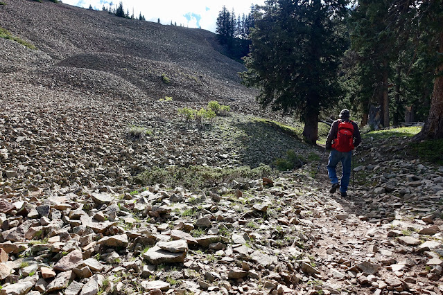


La Plata's largest rock glacier surges out in waves from the peak and its northwest ridge. Burro Mountain, the most northerly ranked summit in the range is an extension of this ridge. Like Sharkstooth, it is a remnant of immensity, the structure that stood in this very place before the forces of erosion had their timeless way. (THW, photo) 


Route: Hike east on the Sharkstooth Trail to Sharkstooth Pass. Off-trail, ascend north-northeast until you are looking directly at the west face of the peak. Pitch east up a shallow gully that sheds from a notch a few yards south of the summit.

Sharkstooth Trail #620 is one of three trails that compose the Mancos Spur. It connects the Western La Platas with the Highline Loop Recreation Trail and the Colorado Trail. The well-established pathway leaves from the east side of the parking lot at elevation 10,900 feet.

The trail skirts the southern runout of the Sharkstooth rock glacier. Picas forage amongst the rocks; a magnificent Colorado blue spruce holds back rolling stone.

Toward the end of August, the woods spoke of impending autumn. After a wet summer, mushrooms were everywhere. Elderberries were an even brighter red than the crimson leaves of fireweed. Osha and delphinium were transitioning from flower to seed. Cobalt blue bottle gentian, the harbinger of winter, spoke to the passage of summertime.
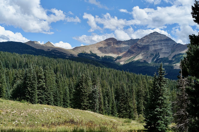
Cross a tributary of the North Fork of the Mancos River on a big, sturdy log at 0.8 mile. Hesperus Mountain, the tallest peak in the La Platas at 13,232 feet, is the banded, laidback triangular slab seen through a break in the timber.

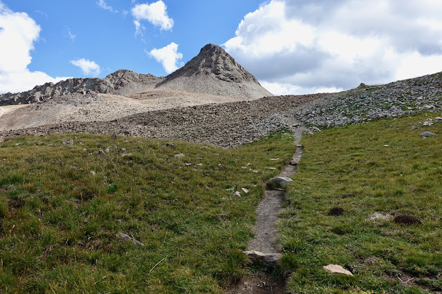
At 11,650 feet, pass above treelimit into the alpine tundra, "...sharp and bare and open, brightly lighted, a land of few shadows." (Land Above the Trees, by Ann Zwinger and Beatrice Willard) Switchbacks moderate the grade, our quarry comes into view, and the trail takes direct aim at the Sharkstooth/Centennial saddle.

Arrive on Sharkstooth Pass, 11,936', at 1.8 miles. (Note: The charming, hand carved Sharkstooth Pass sign went missing in 2021.) Here we leave the Sharkstooth Trail which continues east over "Bear Creek Pass" to link up with the Colorado Trail at Taylor Lake near Kennebec Pass. For most hikers, the pass is a marker on their way to Centennial Peak, 13,062', just 0.8 mile south.
From the pass, Sharkstooth Peak is a 526-foot climb over 0.4 mile. In 2010, I did the roundtrip climb in fifty minutes, but only because I climbed with a skilled navigator who dialed the route without any go-backs. (Eleven years have since passed and neither of us can recall his route precisely.) Most climbers will take 1.5 to 2.5 hours, roundtrip. To begin, head north on the softly rounded ridge until you have a direct shot at the west face of the mountain. Resist the urge to barge up the south face. Yes, some people have been successful using this approach but it is more unstable than the recommended route.

Route Overview
The real challenge begins 200 vertical feet from the top. The summit cone is a small, even intimate, space and the route must be deciphered carefully. Looking at the photo below, the safest passage, and most likely the standard route if there is one, is to climb the shallow gully emanating from the notch right of the apex.

Work your way up and into the gully. At 12,080 feet, the mountain bucks up but the slope is reasonably stable and doesn't get rigorously steep and loose until 12,200 feet.

The fractured rock is poised at the angle of repose. The rock tends to settle in cresting waves--avoid disturbing them. The worst danger is setting off a landslide above you. Navigation is a sustained puzzle. We made progress a dozen feet at a time, readjusting with micro route finding. Soft dirt passages are one clue you are on course.

This image looks down on the gully, more of a debris slide path. The floor of the trough is more stable than the splintered ribs on either side. There are a few good holds but most become dislodged when stepped on or pulled.

This image looks up-mountain from the exact location where the previous photo was snapped. There is no bypass around this exposed Class 3 wall. (Thomas Holt Ward, photo)

The wall ends at a funnel that drains from the notch. (THW, photo)

From the gap it is a short, straightforward walk to the zenith. (THW, photo)

Appropriately, the 4X5 foot fang is the smallest crest of any peak in the La Platas, a good part of its allure. The hard won vantage point has an incomparable view of three thirteeners: Centennial Peak, Lavender Peak, and Hesperus Mountain. (THW, photo)

Swing from Lone Cone eastward to see the San Juans rippling off in the distance. Indian Trail Ridge, the skyway connector between the ranges, is across the Bear Creek Basin. Our friend, Ranger Ott, placed the peak register in October, 2020. About a dozen people have signed since. (THW, photo)


Note on Northwest Ridge
We had heard over the years that the peak was not accessible from the northwest ridge. We wanted to check it out so we did a lateral across the west face and climbed to a small saddle at 12,260 feet, a stunning and dramatic place on the razorback of the rock glacier. We were able to climb about 100 feet on the ridge until we were stopped by a 20-foot cresting wave of rock. (THW, photo)

From the access road perspective, Sharkstooth Peak owns the expression, "Small but mighty."

No comments:
Post a Comment