Travel: From the US 550/160 intersection in Durango, travel west on US 160 for 24.7 miles to the signed Echo Basin Road and turn right/north. Zero-out your trip meter. Stay on the main road, passing old homesteads and hay meadows. In 2.4 miles continue straight on FSR 566 when the road turns to gravel. The road deteriorates at 3.8 miles where winter plowing stops. The track climbs steadily through scrub oak to a cattle guard at 6.4 miles. Directly east is The Hogback. Beyond the guard are literally acres of blooming mule's ears in early summer. At 6.8 miles bear right at the fork, staying on FSR 566. Climbing, the road glides through an aspen forest. At 8.0 the road forks again; stay left. At 9.9 miles, go right. High clearance and good tires are necessary on the rocky track. At 11.5 miles bear left onto FSR 566G and drive downhill to Echo Creek. You will see Hesperus from the road. Park where large boulders prevent further travel, 11.9 miles. Allow 1:05 to 1:15 from Durango.
Distance and Elevation Gain: 7.5 miles, 3,560 feet of vertical
Total Time: 6:15 to 7:00 hours
Difficulty: Abandoned road, off-trail; navigation challenging; easy Class 3 scrambling with mild exposure
Maps: La Plata; Rampart Hills, Colorado 7.5' Quads
Latest Date Hiked: June 24, 2014
Navajo Prayer:
Mother in the earth
Father in the sky
From where the sun rises
To where the sun sets
To the south and to the north
All in my heart
All in my heart. (Scott Thybony, Burntwater, 1997)
Hesperus Mountain marks the northern boundary of the traditional homeland of the Navajo. It is the Sacred Mountain of the North.
Hesperus Mountain as seen from Lavender Peak in November, 2007.

Route: Hesperus Mountain must be climbed via its west ridge. I have explored four approaches, one from the south, and three from the north. There is no easy way to summit. All routes present navigational challenges and demanding climbs. If you prefer to use the standard route, please consult Hesperus Mountain: Northern Approaches.
The Echo Basin Route is a gentler approach to the west ridge. However, it is 2.7 miles longer than the shortest northern approach and adds almost a thousand feet of vertical. Irrefutably, the final mile to the peak is one of the finest in the La Plata Mountains. Looking at the track below, the southern approach poses a substantial navigational challenge between the South Fork of the West Mancos River and the west ridge of Hesperus. The rest is simple.
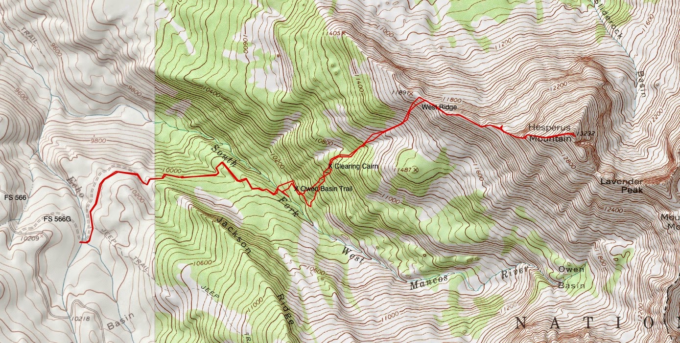

The road bends around the base of Jackson Ridge. At the first fork, go left. At the second, bear right. Thimbleberry, columbine, golden banner, elderberry, and orange sneezeweed thrive. Keep a close eye and an intuitive feel on the road for it is disappearing from lack of use. Looking at the topography below, the navigational objective is to thread your way from the river (hidden) up through the woods to the west ridge.

In 1.4 miles, the road ends. Drop 100 feet on a steep use trail to the South Fork of the West Mancos River, 10,120 feet. Cross it on one of several logs. 2023 Note: Do not attempt to ford the river in high water. A young mountaineer was swept downstream and perished in June, 2023.

Clamber 100 feet straight up the slope to intersect the faint Owen Basin Trail. Leave some mark at this location so you can find your way home. Turn right/east and walk about 200 yards. We went a tad too far and ended up in one of many boulder fields.

Hike steeply uphill heading northeast, always northeast. Try to link clearings, staying near the aspens and small drainages. Flowing creeks harbor brookcress and Parry's primrose. When possible, avoid the conifers which cling to steeper slopes.

At about 10,600 feet, there is a cairn in a forest clearing. It is quite probable you will naturally come to this point. Continue through the clearing, do some more thrashing as you climb, always aiming northeast.

In 2.35 miles, at 11,200 feet, break free of the forest in a swale. Navigation from here is obvious. Whew! Simply step from one tundra tuft platform to another as you scale 700 feet up the steeply angled green slope.

The pitch is covered in edible valerian, medicinal osha, and the primitive green gentian (monument plant), shown looking down at the swale.


Phlox, looking like blinding snow patches, is having an excellent year on the ridge. Its wafting perfume induces alpine euphoria.

Upon reaching 12,300 feet where the real climbing begins, notice a social trail that leaves the ridge and makes for the south side of the mountain. This trail seeks to avoid some of the cliffs on the ridge proper. It baffles me that people use this trail which is a side-hill nuisance most of the way. The surface alternates between sink-up-to-your-ankles in shale, and slippery, resistant soil. The ridge, on the other hand, leads you up the mountain joyously. Begin the climb just to the left of the rock outcrop, shown.

Experience the alternating cliff-slope structure of the mountain while walking up through Mancos Shale to the base of the next cliff band. The climb is characterized by the rock so take a moment to read about the composition of the stone by geologist, John Bregar.
Geological Note:
Hesperus is part of the La Plata Mountain laccolith, which is an intrusion of magma between sedimentary layers, bowing the sediments up, where they get eroded off, and baking the sediments in close contact with the magma to hornfels. The dark and light layers of rock that are so prevalent on Hesperus and Centennial are alternating layers of magma and baked sediment. Generally, the dark layers are sediment, and the light layers tend to be the congealed magma or hornfels. You could call the relatively thin, tabular bodies of magma sills, but really, the whole mass of the La Plata Mountain laccolith is a complicated mess of intrusive and sedimentary rocks.

While the cliff may be skirted on the right, it is a fun Class 3 scramble with secure holds to punch up the short wall.

Hold to the north edge of the ridge, surmounting the rising stone staircase all the way to the crest. The only exposure is adjacent to the precipitous north face of the peak.

Hesperus is the highest eminence in the La Plata Range. The summit is compact but the vista is compelling and commanding. (THW, photo)

Lavender Peak, less than a seemingly impossible mile away to the southeast, is captivating. Skilled climbers have, in fact, traversed the ridge from Hesperus to Lavender successfully. Centennial Peak, 13,062', is the red banded mountain on the left.

Twirling towards the south, The Knife is held down by the Babcock Bad Boys on the left and Spiller Peak on the right.

Further south is the Four Peak Traverse and Helmet Peak.

In the southwest lies Mesa Verde and Sleeping Ute Mountain. Hesperus clearly predominates and deserves respect as the cardinal point of the North. Navajo land and life is secured within the circle of the sacred mountains (Trebbe Johnson). The eastern cardinal point is Sierra Blanca Peak in the Sangre de Cristo Range; in the south it is Mount Taylor in New Mexico; and in the west, Humphreys Peak in the San Francisco Peaks.

In the north is the familiar great swath of the San Juans. For the return, simply down-climb as you came. As you proceed through the woods, following your temporary cairns home, heed the advice of Rene Daumal in Mount Analogue.
When you strike off on your own, leave some trace of your passing which will guide you coming back: one stone set on another, some grass flattened by a blow of your stick. But if you come to an impasse or a dangerous spot, remember that the trail you have left could lead people coming after you into trouble. So go back along your trail and obliterate any traces you have left. This applies to anyone who wishes to leave some mark of his passage in the world. Even without wanting to, you always leave a few traces. Be ready to answer to your fellow men for the trail you leave behind you.

Climbing Hesperus was so deeply satisfying, I will forever carry the mountain in my heart to inform my days.

2 comments:
When you say 6:15 to 7 hours do you mean round trip?
Yes! I just fixed that, thank you. Debra
Post a Comment