Essence: This is the story of the resurrection of a classic trail on the Catalina Front. Palisade Trail No. 99 was once the most heavily used treadway into the high country in the Santa Catalina Mountains. Over time the trail was neglected and became almost impossible to decipher. After avoiding it for years, we recently heard rumors of a major rebuild in the lower reaches. Sure enough, now the footpath is easy to follow for its entire length. Superb engineering makes use of ridge tops, broad shelves, and drainageways. Over seven miles, the trail descends 4,450
feet through multiple life zones while meandering through weathered Catalina granite and gneiss boulders and hoodoos. Commanding views will always be out
in front if you hike downhill, showcasing the magnificence of the Pusch Ridge
Wilderness. The Palisade Trail yields one of the biggest payoffs for the least effort in the range. The trail ends at the East Fork of Sabino
Canyon, one mile east of Sabino Basin and the terminus of the Box Camp Trail. There are considerable similarities between these two premier trails. Strong hikers could combine the two pulling off a mighty loop given a short shuttle on the Catalina Highway. This description exits via the Sabino Canyon Trail and concludes at Tram Stop No. 9. Buy your downhill ticket in advance. The hike is within the Pusch Ridge
Wilderness managed by the Coronado National Forest.
Travel: A lengthy shuttle is required. Drop a vehicle in the main parking lot at Sabino Canyon
Recreation Area and drive to the Palisade Trail
Trailhead.
Sabino Canyon Recreation Area: Located at the
northeast corner of Sunrise Drive and Sabino Canyon Road in Tucson. The parking lot fills on weekends so arrive early. Show your Coronado Recreation Pass, National
Parks Pass, or pay the day-use fee. Tram and fee information. Allow an hour to reach the upper trailhead. Palisade Trail Trailhead: On the Catalina Highway, a quarter mile before the Palisade Visitor Center, at mile marker 19.5, turn left at the sign for Organization Ridge Road, Showers Point Campground, and Palisade Ranger Residence. The road splits. Straight ahead is Camp Lawton and to the right is the Palisade Trailhead. Parking is on the right 0.4 mile from the highway. In the winter, Organization Ridge Road is closed and the gate is locked. Park near the ranger residence and walk down the road. No
facilities, no fees, no water, no dogs.
Distance and Elevation Gain: 10.6 miles to Tram Stop No. 9; 250 feet gain, 4,700 feet loss. Add 3.8 miles if you walk down the paved park road.
Total Time: 5:00 to 7:00
Difficulty: Trail; navigation easy; Class 2 with no exposure; hike on a cool day, autumn through spring, when the trail is free of snow; all streams are ephemeral and Mud Spring is not reliable so carry all the water you will need.
Difficulty: Trail; navigation easy; Class 2 with no exposure; hike on a cool day, autumn through spring, when the trail is free of snow; all streams are ephemeral and Mud Spring is not reliable so carry all the water you will need.
Maps: Mount Bigelow; Mt. Lemmon; Sabino Canyon, AZ 7.5' USGS Quads
Date Hiked: March 20, 2024
Date Hiked: March 20, 2024
History: Hike Lemmon! has a short history of the Palisade Trail, originally called the
Pine Ridge Trail. It was surveyed by E.O. Stratton in 1911 and completed in 1912. It preceded the Palisade Ranger Station constructed in 1934. The telephone line that crosses the trail was installed in 1911
by the Forest Service. It stretched between Sabino Canyon and
Soldier Camp.
Poem:
Long years ago I blazed a trail
Through lovely woods unknown till then
And marked with cairns of splintered shale
A mountain way for other men.
Poem:
Long years ago I blazed a trail
Through lovely woods unknown till then
And marked with cairns of splintered shale
A mountain way for other men.
Arthur Guiterman
Descending on the Palisade Trail, attention constantly vacillates between enchanting stone features in the immediate surroundings and the immense span of earth and sky. Below, a hiker stands on the water-sculpted floor of Pine Canyon above a 100-foot waterfall.
Route: The Palisade Trail begins near the Palisade Ranger Station on the Catalina Highway and descends southwest to its terminus at the East Fork of Sabino Canyon. Hike west on the East Fork Trail and south on the Sabino Canyon Trail to Tram Stop No. 9. Walk or take the tram back to your shuttle vehicle.

The gate to trailhead parking was still locked in mid-March so we parked near the ranger residence and followed the sign for Organization Ridge Road (FSR 7). Our confirmation was a sign for "Palisades Trailhead." (It is a common mistake to add an "s" to Palisade.) The road to the Showers Point Group Campground branches right; stay on the main road.

The Palisade Trail begins on the right side of the road at elevation 7,820 feet. The mileage indicated on the sign to the East Fork Trail is spot on. I had 7.0 miles but we burned 0.2 mile on the spur to play around at the waterworks in Pine Canyon.

The path tracks along the northwest side of Organization Ridge for the first mile. Camp Lawton with Boy Scouts of America is located on the ridge top. Since the trail is north-facing it retains snow well into spring. On March 20, we walked through sizable patches of snow for the first 400 feet in elevation. (Thomas Holt Ward, photo)

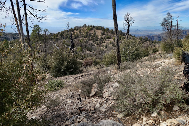
The heavily wooded conifer forest still shows evidence of the Aspen Fire that burned on Mount Lemmon for a month in 2003. Judging from stone steps placed long ago and the Mount Bigelow topographical map, the upper trail adheres to the original alignment built in 1912. The reroute is concentrated below Point 5,950'. The creek in Palisade Canyon was flowing just below the trail. At 0.5 mile watch for a social trail down to a small rock dam. A spur trail on the left climbs to the scout camp. The footpath is composed of dirt, crushed granite, and bedrock.

The trail barges through a hedge of New Mexico locust that has been thankfully trimmed. Across Palisade Canyon was an enticing rock outcrop. You can make out the fire lookout and communication towers on the summit of Mount Bigelow.

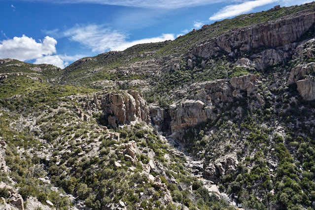
The trail gains the ridge crest and enters the Pusch Ridge Wilderness at 1.0 mile. The ridge seen across the West Fork of Sabino Canyon is topped by McFall Crags, Rattlesnake Peak, and Cathedral Rock. The three summits are among the most enticing (and difficult) to achieve in the Pusch Ridge Wilderness.

The path leaves the ridge top all to soon. At 1.4 miles it goes over Point 7,322', the last numbered point on Organization Ridge, and moves to the southeast side of the Palisade-Pine Creek divide. I thought for sure the trail would go over the roller at 7,260 feet, shown, but no. It flanks it on the southeast and switchbacks down the slope on a footbed of crushed granite and chipped rock. The intrusive igneous stones spent a lot of time underground cooking crystals and they sparkle on the surface. We've left the Temperate Forest biozone behind and are passing through the Madrean Evergreen Woodland with signature madrone, manzanita, juniper, and oak. It is nothing short of gorgeous.
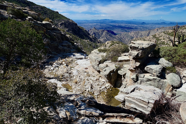
Descending toward the bottom of Pine Canyon, three massive stone buttresses captivate on the opposite wall. The spur trail to the canyon floor and waterworks is adjacent to the lowest buttress. This is the only place on the entire hike where you can easily get down to the creek.

At 2.7 miles, elevation 6,560 feet leave the trail and take a 0.1 mile spur to the creek bed. Do not miss this diversion! Water has carved channels into sheets of polished granite. It's easy for scramblers to work down a series of cascades. We spent considerable time exploring in this outstanding space, fortunate to be there when the water was flowing. (THW, photo)

It is possible to drop to the top of a 100-foot cliff where you can look down to the base of the waterfall. Please use caution! Catalina gneiss is throughout this area and it is notoriously slippery. (THW, photo)

This has to be one of the finest stone sculptures the artisan Earth has ever created.

Below the popular picnic designation (and frequent turnaround for locals), the trail isn't as pounded. The track is thinner and needs a little trimming. However, it remains easy to follow. At 3.0 miles, 6,500 feet, water issuing from Mud Spring was flowing over the trail. Reportedly, the water in a concrete catchment to the right of the trail is clear and cold. We looked casually around for it and didn't find the tank. The trail crosses and recrosses a north fork of Pine Canyon. It is a small waterway with big boulders. Further down we entered a shady drainage with large alligator junipers. The trail moves west briefly to face the south wall of the divide with Palisade Canyon.

The tallest falls in Pine Canyon are noted on the Mount Bigelow quad. They plummet over a band of crenelated cliffs. The best view is at 3.7 miles, 6,020 feet. (THW, photo)
In this closeup you can make out a delicate stream of water. A secondary channel is stained white. (THW, photo)
Turn your attention down canyon to see a remarkable square tower. This is an exceptional elevation in the range where massive stone features and hoodoos are common. Thimble Peak, one of Tucson's prideful landmarks, is still 700 feet below this location.

Over the years resurrection moss has taken hold in the cracks of the well-constructed retaining walls. These block walls are your indicator that you are closing in on the telephone line that stretches across the trail.

Orange flagging at 3.9 miles, 6,040 feet, alerted us to the telephone wire but the ribbon may not be present for you. Below, my partner is holding the wire. A short distance further on was a trip wire at ankle level.

Round the corner and the trail contours west over sheets of bedrock. Trail engineers used this spectacular flat shelf to transition from the east side (Pine Canyon) to the west side (Palisade Canyon) of the divide. (THW, photo)

The trail cranks sharply to the south and passes over Point 5,950'. While we didn't even notice this subtle marker, the Palisade Trail was rerouted from there. Previously, it plunged steeply down three ridges all the way to the East Fork. Major switchbacks have since been introduced to moderate the grade. Be on the alert for a ramp of rock at 4.4 miles, 5,860 feet, shown.

We were in a state of suspension while walking on stone.

It was a thrilling sensation hanging out in space.

As seen from the ramp, Palisade Canyon is clearly a much larger drainageway than Pine Canyon. (THW, photo)

My favorite segment on the whole trail is from the ramp to another significant stone platform a mile off. The trail reroute was masterfully done. It threads through troughs of rock, between boulders, over slabs. It's fun, graduated, and friendly. We could hear the falls in Palisade Canyon. Frankly, we were disappointed this namesake trail doesn't visit or even look down into the many waterfalls in Palisade Canyon, so evident from the Box Camp Trail.

At 5,520 feet, the trail turns due south and holds that bearing for 0.6 mile. For the first time, we could see partially down into Sabino Canyon, our final destination.

The aforementioned stone shelf at 5,360 feet, 5.1 miles, was an excellent lunch spot. We could study the whole trail system in Sabino Canyon. (THW, photo)

We fully expected to plunge directly on the westward ridge. Instead, the reroute took us so far north I began to wonder if we were on the right trail. This beautiful Arizona oak lives beside the trail in the switchbacks.

Eventually we made contract with the west ridge. We had arrived in the Semi-Desert Grassland biozone. At 4,500 feet a string of three-foot-tall cairns on the ridge top heralded the final bend in the trail's trajectory.

At 6.4 miles, the trail spins to the southeast and works its way down to the East Fork. Below, the East Fork Trail zigzags up the flanks of Point 4,986' to Sycamore Saddle. Peak 5,420', image-right, is one of the finest scrambles in the Pusch Ridge Wilderness.

We were now in the realm of sotol, pricklypear, ocotillo, staghorn cholla, and coralroot. We scared up four coatimundi. (THW, photo)

Hop across the bouldery East Fork of Sabino Canyon at 7.0 miles, 4,100 feet.
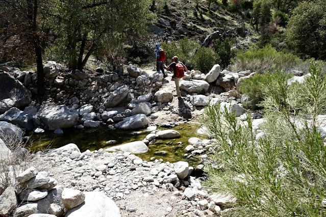
This is mere steps from the signed junction of the Palisade and East Fork trails. Turn right, unless you intend to exit at the Hirabayashi Trailhead (longer hike, shorter shuttle).

The East Fork Trail doubles as the Arizona Trail and it presents as a cross-state trail should--wide platform, smooth surface, and pleasant grade.

The junction with the Box Camp Trail occurs in Sabino Basin just before the left turn onto the Sabino Canyon Trail. It would be an epic day to do a down-and-up on the two trails. Which trail do I prefer? I have a slight prejudice for the Box Camp Trail, perhaps because I hiked it first. My partner prefers the Palisade. It is better defined than Box Camp was in 2020. He thinks there are more huge viewpoints, bench walks, and spheroidals. It baffles me that two trails in such close proximity were built back in the day.
For the rest of us mere mortals walking out at Tram Stop No. 9, turn left onto the Sabino Canyon Trail at 8.0 miles, 3,700 feet. Bust up a short incline (feels so good!) and walk out to an overlook at 8.25 miles. From there you can look up the West Fork of Sabino Canyon and catch your final glimpse of Cathedral Rock.

The Sabino Canyon Trail is one of my absolute favorites. It's perched up high on the east wall of the canyon. It holds the contour while dashing in and out of minor side drainages for over 1.5 miles. Look down into the constricted gneiss gorge and clear up to Mount Lemmon. Sitting atop walls of rock is Thimble Peak, image-left. It's nothing short of trail insanity.

The trail hangs almost 400 feet above the canyon floor.

Black and white banded Catalina gneiss glistens in mid-day sun. It is positively electric.

See Sabino Canyon Road and the upper tram stop well before you arrive. When you get to the junction with the Phoneline Trail, you have half a mile of solid switchbacks to trail's end.

Reach the lower trailhead at 10.6 miles, elevation 3,334 feet.

Be sure to swing around and admire raw, unadulterated beauty as you exit from one of the finest trail systems in the Sonoran Desert.

Flowers came on late in 2024. We noted the following bloomers: Texas toadflax, desert anemone, Santa Catalina prairie clover, sundrop (evening primrose), fairyduster, shrubby deervetch, Mexican gold poppy, scorpionweed, wild hyacinth, Santa Catalina phlox, manzanita, and tiny uncommon redmaids, shown. (THW, photo)

1 comment:
Debra and T thanks for shepherding me down!
Post a Comment