Essence: Climb three peaks and two striking stone promontories on Incinerator Ridge east of the Palisade Visitor Center. The Bigelow, Kellogg Mountain, and Incinerator Ridge trails access the off-trail climbs. The hike begins from the Bigelow Trailhead, 600 feet higher than trail's end at San Pedro Vista. Drop a shuttle vehicle, or walk two miles up the Catalina Highway. The hike is on the far eastern perimeter of the Santa Catalina Mountains in the Coronado National Forest.
Travel: For the shuttle, drive up the Catalina Highway (aka General Hitchcock, Mount Lemmon highways) and leave a vehicle at San Pedro Vista on the right, Mile Marker 17.4. Continue up the highway, passing Incinerator Ridge Road and a sign for Palisade Visitor Center, 1/4 mile. Bigelow Trailhead parking is on the right side of the road at Mile Marker 19.5. If you come to Palisade, you've gone too far. Pit toilet, picnic tables, no water. Fees were forgiven in 2021 but be ready to display your pass.
Distance and Elevation Gain: 5.2 miles; 1,350 feet of climbing
Total Time: 3:45 to 5:00
Difficulty: Trail, off-trail; navigation moderate; Class 2; no exposure (optional Point 7,820' is Class 3 with considerable exposure); carry all the water you will need; avoid when trails are snow-covered; thorns on Kellogg--wear long pants.
Map: Mount Bigelow, AZ 7.5' USGS Quad
Date Hiked: November 30, 2021
Quote: In things beautiful there is an eternity of peace, and an infinity of sight. John Alec Baker
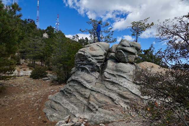
Incinerator Ridge has many stone nubbins and knobs that beckon playful hikers. The terrain drops steeply to the east, settling out in the vast San Pedro River Valley only to rise up once again into the Galiuro Mountains.
(Thomas Holt Ward, photo)
Route: From the Bigelow Trailhead, hike north to the Mount Bigelow-Kellogg Mountain saddle. Ascend west to Mount Bigelow. Return to the saddle and climb east off-trail to Kellogg Mountain. Return once more to the saddle and walk southeast on the Kellogg Mountain Trail. Transition to the Incinerator Ridge Trail and ascend Incinerator Peak, Leopold Point, and Barnum Rock. Climbers may wish to scramble up Point 7,820'. Continue southeast and finish at San Pedro Vista.
Mount Bigelow, 8,540'
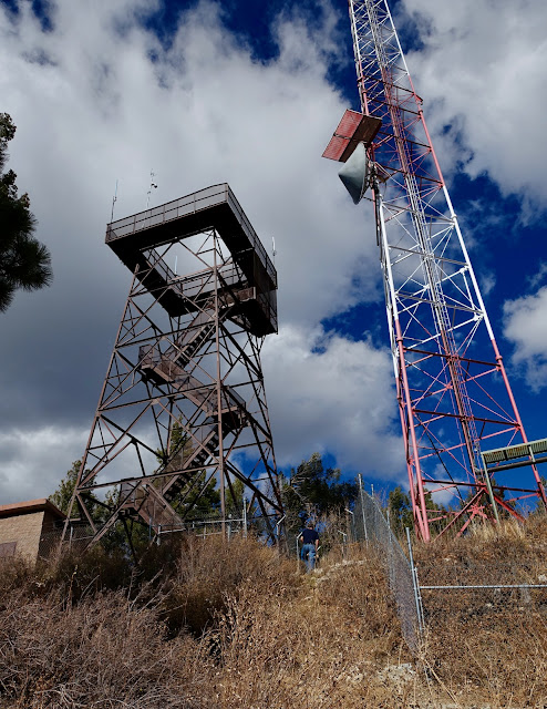
The Bigelow Trail bears north out of the parking lot, elevation 7,940 feet. The dirt path is softened by forest duff, stately ponderosa pines are generously spaced, the forest is uncluttered, and the grade is gentle. At 0.2 mile, the footpath turns sharply to the right, crosses a draw and ambles lazily up the forested slope. Below, the communication towers on the summit of Mount Bigelow can be glimpsed at the start of the hike.
Weathered Catalina Granite boulders are dispersed amongst the trees. If you are a fan of granite, this hike is for you. It's in the center of a massive swath of exposed granite in the Catalina range. I fell in love with this trail as soon as I set foot on it and wondered how it took me so long to discover the sweet pathway.
Arrive on Bigelow Saddle, 8,260 feet, at 0.6 mile. Three trails join in the saddle at a signed junction. The Butterfly Trail continues straight ahead, Kellogg Mountain Trail takes off to the east, and the Bigelow Trail cranks to the west/left. The treadway takes direct aim on the five red and white communication towers that completely take over the industrial summit. The trail ends at the road servicing the towers, 0.9 mile.
To reach the crest, turn right on the road. Just uphill from the fire lookout tower, a short trail climbs 20 feet to the summit. Reach the highpoint of the hike and only ranked peak at 1.0 mile. We were not able to find the benchmark referenced on the topo map and in Hike Arizona.
With an 800 foot rise, Mount Bigelow is well positioned for a fire lookout. In July of 1926, the station reported a forest fire of several acres on the east side of the Galiuro Mountains. The current steel structure replaced the original wooden lookout in 1929. The tower is still used by the U.S. Forest Service as needed for detection.
While Mount Bigelow feels like the busiest mountaintop ever, the vista from the service road is far-and-wide. Below, Incinerator Ridge dips down in waves from Kellogg Mountain. Retrace your steps to the saddle.
Option: Palisade Rock 8,310'
If you are curious about Palisade Rock as we were, start out on the trail toward the saddle. Less than a tenth of a mile below the road, leave the trail and descend south for about 200 feet over 0.1 mile on the rounded ridge, the blue-line route on the map above. The actual highpoint, shown, has a rise of 20 feet and is an easy scramble. It is at the north end of the bulbous outcrop overlooking the Palisade Visitor Center.
Kellogg Mountain, 8,401'
From the saddle, it is only 0.2 mile to the summit of Kellogg Mountain with a 121-foot rise. According to past trip reports, there once was a beaten path along the crest of the west ridge. The landscape has been radically altered by the Bighorn Fire that scorched 119,987 acres in June and July of 2020. The fire spared the Bigelow Trail, Palisade Rock, and the
summit of Mount Bigelow but it swept over
Kellogg Mountain and Incinerator Ridge. The informal trail has disappeared from post-fire trauma and vicious thorny plants are unavoidable. However, the west ridge remains the only reasonable route to the top.
The crest of the unranked peak, 1.6 miles, is known for its tall summit cairns and westward lookout. Clearly, there is local affection for this little hill. The mountain is named after prospector Alexander Kellogg who had a cabin on the mountain in the 1890s. (THW, photo)
Incinerator Peak, Point 8,135'
Return down the west ridge and hike east on the Kellogg Mountain Trail, a half mile connector between the Mount Bigelow saddle and the upper end of Incinerator Road. The old trail with its stone retaining walls cut into the steep slope contours right under the south face of the mountain. My friend remembers lush green ferns and plentiful wildflowers. We were off-season for flowers but the trail had undoubtedly gotten more wild. It plows through the dreaded graythorn and brush tunnels. The pathway switchbacks down Kellogg's southeast ridge with an open view of the next wooded roller, Incinerator Peak.
Incinerator Road comes up from the Catalina Highway and intersects the trail system in the Kellogg Mountain-Incinerator Peak saddle at 2.4 miles. Technically, both the Kellogg Mountain and Incinerator Ridge trails begin here. Transition onto the Incinerator Ridge Trail which bears southeast to San Pedro Vista. There is dispersed camping and plenty of parking for those who want to hike in either direction from here. This was the location of an old dump and the namesake incinerator but we somehow neglected to search for either.
Just 0.1 mile further on is another sign at the start of the Knagge Trail that drops off the ridge to the northeast. For a detailed description of the trail and its history (The Knagges are a well-known Arizona pioneer family.), please link to Hike Arizona. The sign indicates Incinerator Peak is 0.4 mile afar. We glided over it effortlessly at 2.7 miles. The field of vision opens. To the west, look down on the heliport at Sollers Point and Rose Canyon Lake. And in the east, golden mountains flow into the San Pedro River playa. Leopold Point, image-right, is composed of a community of stone.
Leopold Point 8,060'
Leopold Point is just 0.1 mile off the trail with a rise of 80 feet. To make a small loop, leave the trail in the saddle and ascend on a social trail that wraps around the north ridge to the east side of the boulders before cutting back to the west. Or, you could simply take the westside trail to the summit. Either way, you'll be walking through avenues of towering boulders. Leopold was severely scorched by the Bighorn Fire but clusters of massive stone live on to gladden the hearts of visitors.
The summit, 3.0 miles, is a smoothly rounded rock plate whose vista encompasses an immense span. Nearby, Edgar Canyon cuts between Evans Mountain and a peak-studded ridge angling northeast and terminating at Davis Spring. Rising above all else is Mount Graham in the Pinaleño Mountains. (THW, photo)
Barnum Rock, 7,954'
Back on the trail heading south, there are fabulous views of Leopold's southeast rockscape, composed of towering outcrops stepping down in succession. Backcountry camps are just off the trail in the Leopold-Barnum saddle. The main trail gains the north ridge of Barnum and then diverts to flank it on the west. Stay on the north ridge for the 174-foot climb to the rounded crown, shown.
Barnum Point, 3.7 miles, is a rolling series of elevated slabs. We were ecstatic to be on this massive buttress. Climbers must agree because there are anchors all over the mountain. Look back on the four prominences climbed thus far.
San Pedro Vista and Optional Point 7,820'
To reach San Pedro Vista, retrace your steps to the trail. It curves to cross Barnum's south ridge in front of Point 7,820', shown. The half-moon edifice is an optional addition for experienced scramblers.
As shown on the map above, we left the trail once again to check out another nubbin to the southwest. There is exceptional rose colored quartz in this area. From the cap we got an enticing view of Point 7,820'. There are two routes up the aggressive monolith. My partner scaled the west ridge and a friend went up the north face. There is considerable exposure either way.
The west ridge is a Class 3+ scramble with a short razorback leading to the crest.
The alternative approach is a friction pitch on the north face. I shot this on the downclimb.
This image was taken from the top of the point. I'm standing in the gap between the lesser outcrop and the main wall. (THW, photo)
The Incinerator Ridge Trail winds down fairly steeply on a rough, undulating track. We diverted a couple of times from the boulder staircase to check out appealing outcrops. This image looks back at Barnum Rock.
We had the trail and assorted, delightful offshoots all to ourselves even though the Catalina Highway was close by for the duration. Point 7,820' and Barnum Rock are visible from trail's end at San Pedro Vista, elevation 7,340 feet.


No comments:
Post a Comment