Essence: Peak 5,420' is a ranked summit northeast of Thimble Peak with 840 feet of prominence. It presents a delightful adventure for proven scramblers familiar with complex desert terrain. The off-trail segment is less than a mile long but it's a 1,000 piece puzzle. This description assumes hikers are familiar with the trail system to the Thimbles. Having climbed Thimble East many times, we answered a curiosity. Is it possible to traverse between Thimble Peak and its jaw-dropping parent (97 feet higher) to the east? (Not without a major bypass from the wandering arête.) While this hike is best conducted as an out-and-back to Peak 5,420', I will describe what we encountered on the truncated traverse.
Travel: Drive up the Catalina Highway past Molino Basin. Turn left at the sign for Gordon Hirabayashi Recreation Area at mile marker 7.3. The trailhead is beyond the campground, 0.3 mile from the highway. Pit toilets, no water.
Distance and Elevation Gain: 8.8 miles; 2,100 feet of climbing. Add Thimble East and it is 11.4 miles with 3,000 feet of vertical, total. Total Time: 5:00 to 6:30; Thimble East adds about 2:00
Difficulty: Trail, off-trail; navigation challenging; Class 3 with mild exposure; Thimble East is Class 4 with moderate exposure.
Pusch Ridge Wilderness: This hike lies east of the desert bighorn protection area so those restrictions do not apply. Dogs are not allowed in the Pusch Ridge Wilderness.
Maps: Agua Caliente Hill; Sabino Canyon, AZ 7.5' USGS Quads, or Pusch Ridge Wilderness, Coronado National Forest, USDA Forest Service, 1:24,000
Date Hiked: February 25, 2021
Song:
Because I'm happyMaps: Agua Caliente Hill; Sabino Canyon, AZ 7.5' USGS Quads, or Pusch Ridge Wilderness, Coronado National Forest, USDA Forest Service, 1:24,000
Date Hiked: February 25, 2021
Song:
Clap along if you feel like a room without a roof
Because I'm happy
Clap along if you know what happiness is to you.
—Pharrell Williams
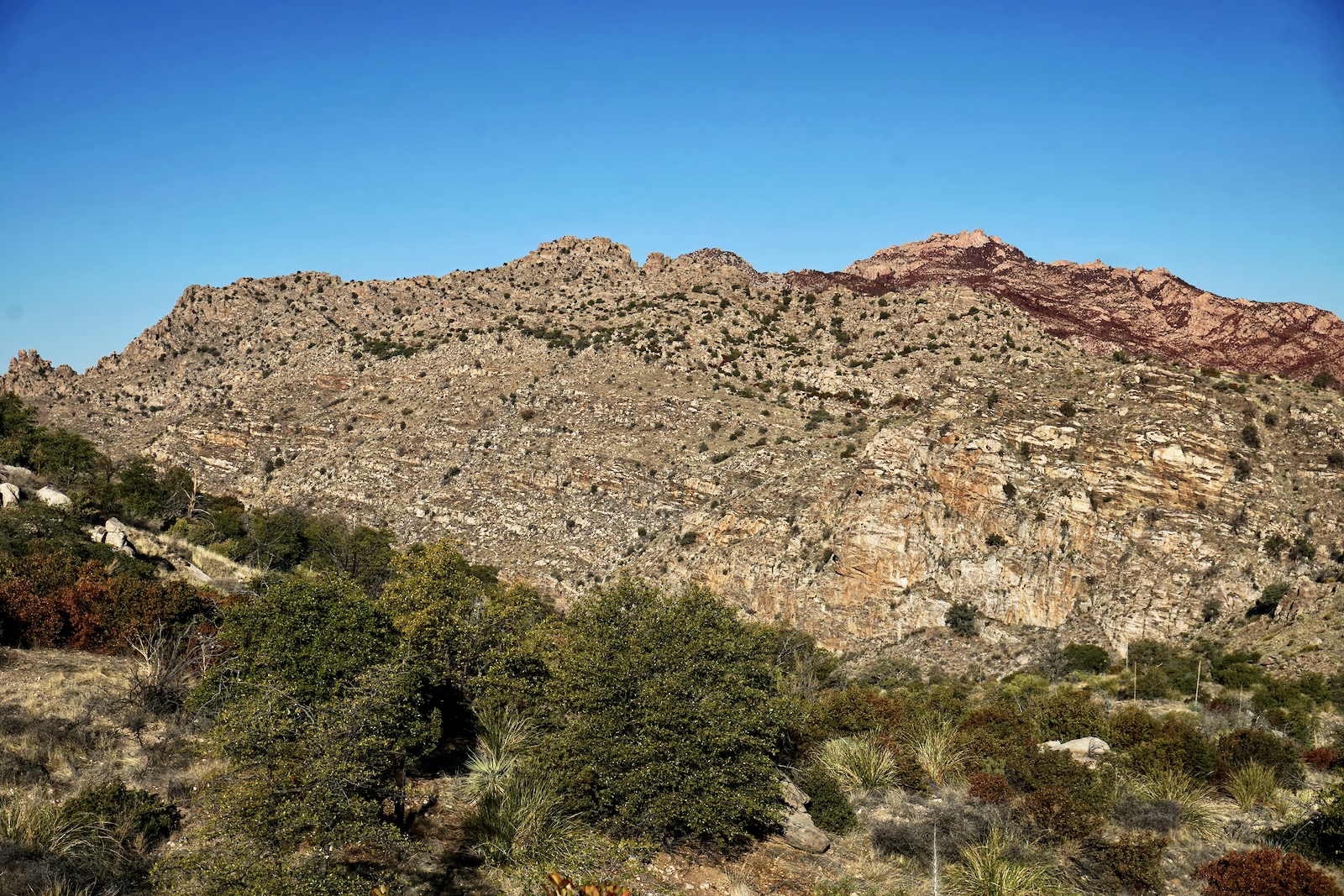
From the Thimble platform, Peak 5,420' looks both irresistible and formidable. You needn't scale the fortress wall at the southwest end of the summit ridge, shown. The mountain is best approached via the east ridge.
(Thomas Holt Ward, photo)

Route: From the trailhead at Hirabayashi, hike northwest over Shreve Saddle on the Sycamore Reservoir Trail. Take the Cut-Off Trail west to the Bear Canyon Trail. Climb west-southwest off-trail to the summit of Peak 5,420'. Return as you came on the black-line route. The blue-line shows our exploratory route from Peak 5,420' to Thimble. Forced off the ridge, we segued to the standard Thimble Peak trail.

Enter the Pusch Ridge Wilderness at Shreve Saddle, elevation 5,020 feet, 1.1 miles. It is located on the divide between Soldier and Bear canyons, the low point between Gibbon Mountain and Peak 5,506'. Cathedral Rock strikes a strong presence, the dominant force on the skyline. Peak 5,420' is the highpoint on the east-west ridge in the foreground. (THW, photo)
The 600 foot descent into Sycamore Canyon is on a classic trail built long ago, the grade carefully managed and interspersed with staircases. Half hidden in the brush are historic stone pillars that once supported the water line running from the reservoir to the Prison Camp.
To the east is the multi-tiered Mt. Lemmon Highway. In the image below, Windy Point is located on the upper road wrap, image-left. The climb to "Tower Stack" (image-center), Peak 6,191' (image-right), and Peak 6,512' (off-image) is quite similar to this hike.
To the east is the multi-tiered Mt. Lemmon Highway. In the image below, Windy Point is located on the upper road wrap, image-left. The climb to "Tower Stack" (image-center), Peak 6,191' (image-right), and Peak 6,512' (off-image) is quite similar to this hike.

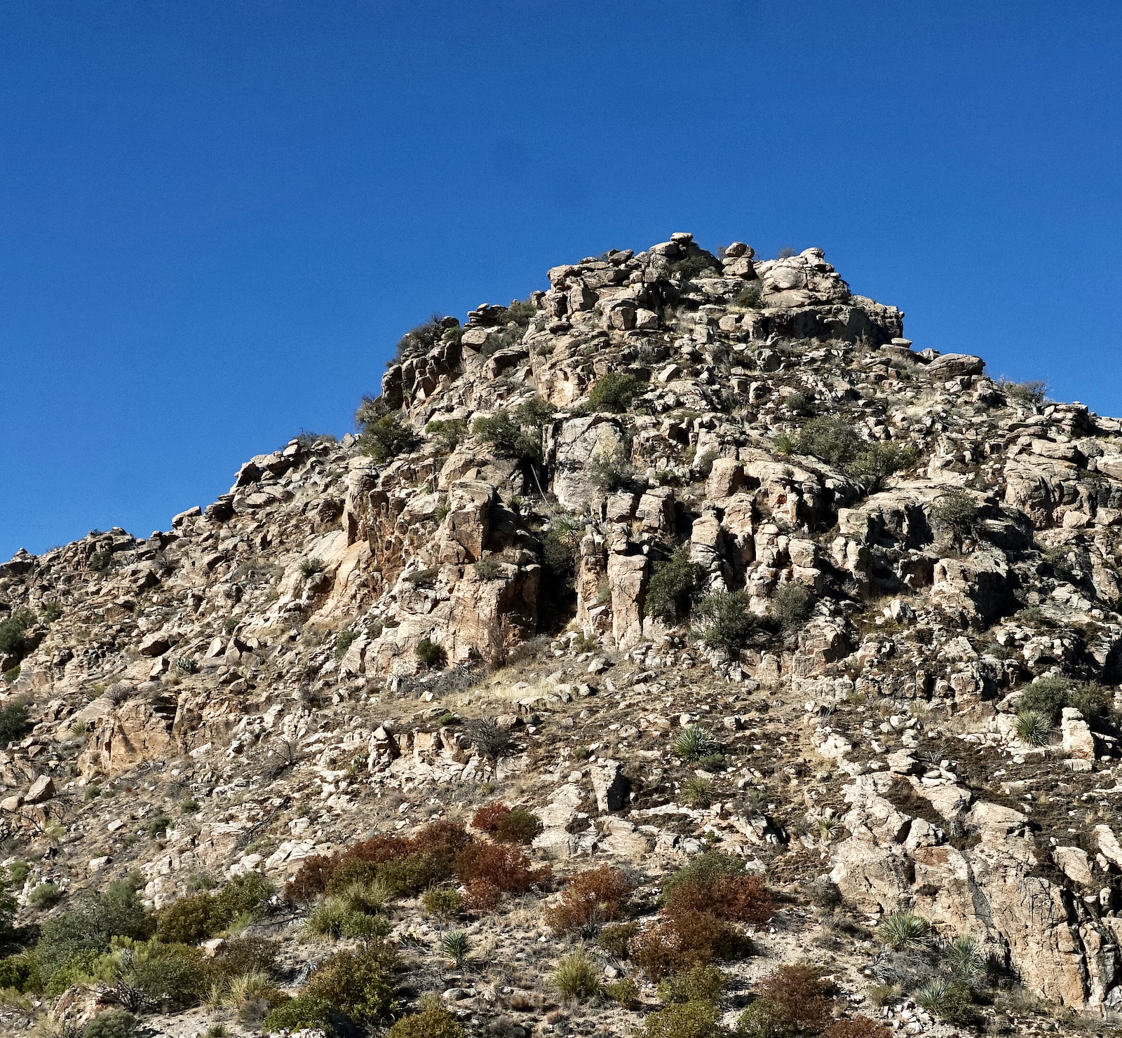
Near the confluence of Bear and Sycamore canyons is a signed spur trail to Sycamore Reservoir at 2.3 miles. Turn right and cross the Bear Canyon drainageway. The trail rises imperceptibly on the bottomland of Sycamore Canyon. At 3.1 miles, a big-stack cairn marks the unsigned Cut-Off Trail, the original Bear Canyon Trail. Crossing the braided drainage is generally a non-issue. However, when the wash is running the ford is tricky. The maintained trail climbs steadily for 300 feet on a crunchy mix of crushed granite threading between slabs of bedrock and resurrection moss. The pronounced east ridge of Peak 5,420' is visible from the trail, shown.

The Cut-Off Trail ends upon reaching the Bear Canyon Trail at 3.5 miles, 4,800 feet. The trek is off-trail from here. Ridge purists may begin climbing right from the junction, a slightly brushier option, shown. Or, turn left on the Bear Canyon Trail. In 0.1 mile, leave the trail, mount north, and angle over to intersect the east ridge. There is more than one route to the peak. I will give you a set of instructions based on our ascent route but capable climbers can exploit other options. For everyone, the standard rule applies. Stay on the ridge unless you are forced off.

The east ridge is composed of a series of stone knobs. Top one and there's inevitably another just ahead--great fun! Knock off 100 vertical feet at a time as passages open. The first significant knob is best scaled through the low Class 3 keyhole, shown. Holds are good but check the integrity of the boulders. At the top of the keyhole, go right immediately, returning to the center of the ridge. The remainder of this first test is surprisingly friendly considering how steep it is. Big boulders hold the ground down. (THW, photo)
Just as game trails guide through steep and uncertain mountainous terrain, resurrection moss often indicates the best footing through boulder fields in the Pusch Ridge Wilderness. Rock hopping is a never-ending delight on this journey.

At 5,100 feet, the peak (image-right) becomes your guide. (THW, photo)

Encounter a near-vertical wall at 3.9 miles, 5,180 feet. This obstacle forced our only significant bypass. We hiked south on a bench while hugging the base of the wall. (THW, photo)

In less than 0.1 mile, we cut west up an earth ramp. The balancing rock at the top of the ramp is your reassurance cairn.

To return to the ridge, some climbers will be able to scale the ten-foot wall at the top of the ramp. We kept going through the crack, giving up about 20 feet. We hooked a 180 up a chute filled with big boulders. From there we turned north and returned to the east ridge at the top of the outcrop we'd bypassed. If you'd rather, after the 20-foot descent you may short-cut across to the east ridge, avoiding the hump.

We were rewarded with a remarkable view of Peak 5,420'.

Stay on the ridgetop, dodging minor obstacles and about 100 feet below the crest you will pass a line of standing-up-rocks at the base of an impassible wall. (THW, photo)

Move left a short distance and then climb up through the open slot, shown.

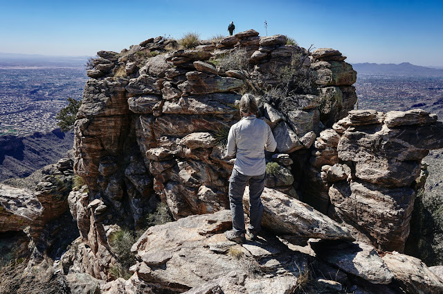
Arrive in a small, flat haven gathered in by three towers. We scrambled up the southwest stack, summiting at 4.4 miles. The north tower, shown, might be a few inches taller but the exposure was too great for us to even consider this conquest. As it is, you have to keep centered and seated to take in the familiar and spacious world spinning around the slim spire.

The easiest option is to return as you came and that is the true intent of this post. Doing so requires very close attention to replicate the upcoming route.
We had been curious for years about the ridge traverse between Peak 5,420' and Thimble Peak. I don't recommend the blue-line route unless you really want to combine the two peaks. We got to Thimble alright but were forced off the ridge well in advance of the 4,900 foot saddle. On our bailout we encountered moderate exposure. I'll describe what we did and you can decide if this is something you'd like to tackle. (THW, photo)

It was pretty effortless to the first significant outcrop on the southwest ridge. It's worth going this far just for the view back to the three-tower cluster topping Peak 5,420'. The sitting spire is on the right. (THW, photo)

Just 0.3 from the summit, we were cliffed out in a community of needles resting on the precipice of a truly massive cliff. (THW, photo)

Rather than turn back, we continued probing by veering southeast. This dumped us on a slope so steep, self-arrest was questionable. We cautiously picked our way down to a safe landing. This image depicts the mellow part of the descent.


On the spur of the moment, we decided to take a quick side trip to Thimble East. At 5.2 miles, 4,720 feet, we intercepted the Thimble social trail just before it swings through a side canyon of Bear, 0.8 mile from the monolith's base. Thimble Peak looks out over a bucolic grassy plain enlivened by sotol, beargrass, pricklypear, yucca, and Arizona oak.

(THW, photo)


Boulders are tossed about on the East aerie. It is a supreme place to alight for moments or hours. The image below captures a climber on the higher West crest, a technical climb. I'm looking at the standard route up a sheer wall.
(THW, photo)

We watched in awe as a life-long Tucson resident and accomplished mountaineer skillfully down-climbed a chimney to the side of the standard wall. I have not tested this route. Attempting this dangerous feat without protection is strongly discouraged by this blog. (THW, vertical pan)

If you are not sure how to get yourself back to Hirabayashi, please consult my Thimble Peak post. If you have energy to burn after ascending to Shreve Saddle, climb another legal summit. Peak 5,506' is accessed by a social trail heading northeast from the saddle. It climbs 486 feet over 0.6 mile to the top of yet another happy world.
2 comments:
This is a fantastic route! Thanks for sharing. Saw this ridge from Gibbon recently and thought it looked interesting. Great to see this write up to corroborate its a viable route. Super fun!
Hi David, Mountains have differing personalities, right? Some are serious but others are playful. Thank you for confirming that this peak is in the pure fun column. And thank you for your contribution to Earthline. Debra
Post a Comment