Essence: Rattlesnake Canyon cleaves the north flank of the Uncompahgre Plateau, plummeting 2,000 feet to the Colorado River at Horsethief Canyon. Rattlesnake contains one of the largest concentrations of natural arches in the United States; some say it ranks second only to Arches National Park. The rugged and demanding 4WD road to the trailhead, open April 15 through August 15, assures solitude. The Upper and Lower Rattlesnake Trails diverge a short distance into the hike. Generally, they are hiked as out-and-backs, tackled in one day. The hike described here begins on the Lower Trail running along the base of the arches and connects with the Upper Trail via a steep friction pitch through Cedar Tree Arch--for skilled canyoneers only! Walk the Entrada Sandstone rim and look down through the windows. There is an optional spur to stand-alone Window Rock Tower. The hike is west of Grand Junction, within both the Black Ridge Canyons Wilderness and the McInnis Canyons National Conservation Area, administered by the BLM.
Travel: Rattlesnake Canyon is accessed from Black Ridge Road, located roughly halfway between the East and West entrances of the Colorado National Monument, 6.5 miles east of the Visitor Center. You will need 4WD with high clearance for the last few miles to the trailhead. The rough technical road has steep switchbacks and lumpy bedrock. (Alternatively, you can access Rattlesnake Canyon from the Pollock Bench Trailhead but the hike is significantly longer.) At the junction of Rim Rock Drive (main park road) and Black Ridge Road, turn west and measure distance from there. The road turns to dirt upon crossing a cattle guard; it is impassable when wet. Turn right at 0.2 mile, leaving the Monument and entering McInnis Canyons National Conservation Area. Climb switchbacks. At 1.5 miles, go left at the sign for Upper Black Ridge Road, Upper Rattlesnake Arches. At the top of a steep gravel hill, pass through an open gate at a cattle guard, 2.5 miles. This gate is locked during the closed period. At 4.7 miles, branch left at a Y. (Straight ahead, the road climbs to a dispersed camp at Point 6,883'.) At 7.1 miles, and again at 7.2 miles, stay to the right. Descend super steep switchbacks off the plateau. It's slow going from here. Park at road's end, 10.2 miles. No facilities.
Distance and Elevation Gain: 7.2 miles (includes Window Rock Tower); 600 feet of climbing. The out-and-backs on the Lower and Upper trails is 7.4 miles. (Add 1.1 miles for Window Rock Tower.)Total Time: 4:30 to 6:00
Difficulty: Trail, off-trail; navigation moderate; Two Class 4 friction pitches with moderate exposure (rope recommended); carry plenty of water and hike on a cool day.
Map: Mack, Colorado 7.5' USGS Quad; Trails Illustrated No. 208: Colorado National Monument, McInnis Canyons National Conservation Area
Reference: The Natural Arch and Bridge Society is a science-based, volunteer non-profit organization promoting the study and preservation of natural arches and bridges. I consulted their encyclopedic website for the formal USGS names and arch statistics cited in this post.
Date Hiked: May 5, 2021
Quote: Standing there, gaping at this monstrous and inhuman spectacle of rock and cloud and sky and space, I feel a ridiculous greed and possessiveness. I want to know it all, possess it all, embrace the entire scene intimately, deeply, totally. Edward Abbey
Quote: Standing there, gaping at this monstrous and inhuman spectacle of rock and cloud and sky and space, I feel a ridiculous greed and possessiveness. I want to know it all, possess it all, embrace the entire scene intimately, deeply, totally. Edward Abbey
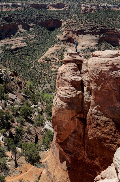
Hikers stand on the Entrada Sandstone rim overlooking Centennial Arch. The span embraces and contains a massive volume of hollowed-out space. (Thomas Holt Ward, photo)

Route: For the hike described, begin at the Rattlesnake Arches Upper Trailhead and walk northwest on the red-line trail to the junction of the Upper and Lower Trails. Descend north on the Lower, blue-line trail. Take the purple-line spur east to Window Rock Tower. Continue west on the Lower Trail and then curve southeast into Rattlesnake Canyon. At the end of the Lower Trail, climb through Cedar Tree Arch to gain the canyon rim. Walk northwest on the black-line rim route. Return on the green-line Upper Trail. For those doing out-and-backs on the Lower and Upper trails, the rim walk is easily accessed from the Upper Trail. Note: the Mack topo has 20 foot contours.

The Rattlesnake Arches Trailhead looks out over the Book Cliffs and the Colorado River meandering through the Grand Valley. At elevation 5,860 feet, the trailhead is the highpoint of the hike. Descend east, then northwest while watching for abundant wildlife: deer, bighorn sheep, and mountain lion.

Five distinctive geological formations are seen on this hike. The access road and trailhead rests on the Morrison Formation. The Jurassic sedimentary rock, composed of mud and siltstone, sandstone, and limestone, is a fertile source of dinosaur fossils. The Morrison overlies the arch-forming Entrada Sandstone, the focus of this hike. The Entrada is held up by the ledge-forming Kayenta Formation. Underlying the Kayenta is cliff-forming Wingate Sandstone. The floor of Rattlesnake Canyon is within the colorful, slope-forming Chinle Formation.

The Upper and Lower trails split half a mile into the hike. Turn right on the Lower Rattlesnake Arches Trail. The well-engineered path steps down through Entrada Sandstone. Reach a second signed junction at 0.7 mile. Turn left toward Lower Rattlesnake Arches to stay on the blue-line Lower Trail. For those taking the purple-line spur to Window Rock Tower, turn right toward the Pollock (Bench) Trailhead. This track connects with the Pollock and Flume canyon trails and the lower trailhead for Rattlesnake Canyon.
Window Rock Tower
The spur to Window Rock Tower is 1.1 miles roundtrip. Walk east on flat, Kayenta-red earth while scanning for arches in the cliffs above. Branch southeast on a well-trodden path at 1.0 mile. Unlike other arches highlighted in this post, Window Rock Tower is an isolated fin arch, a stand-alone remnant separated from the Entrada rim. "South American Arch," has a six-foot span. The U.S. Board on Geographic Names has given official names to the most notable arches visited on this tour. Informal names are indicated with quotes.

Lower Trail
Return to the main trail and continue west. Sensuous, organic sandstone forms captivate in subtle shades of red blush and bisque. Blossoming wildflowers cast brilliant dots of color throughout the piñon-juniper woodland: milkvetch and buckwheat, rockcress and larkspur, popcorn flower and spring parsley, Perky Sue, peppergrass, Indian paintbrush, phlox, globemallow, wallflower, townsendia, and scarlet gilia, shown. Other common desert flora include sagebrush, rabbitbrush, snakeweed, narrowleaf yucca, prairie pricklypear, and ephedra. (THW, photo)

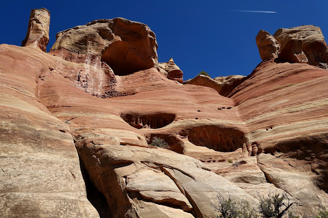
Round the corner into Rattlesnake Canyon at 2.9 miles. The entire series of arches on the upper wall of the canyon are formed along the Entrada Sandstone cliff face. The Lower Trail rests on the Kayenta Formation at the contact with the Entrada. The route never drops to the canyon floor.
Hole in the Bridge Arch and its companion "Leftside Arch," appear right away. Its name references the secondary opening formed by a pothole in the main lintel, shown. It is classified as an adult (most of the alcove roof has collapsed) cave arch with a span of 40 feet and opening height of 30 feet.
Rattlesnake Canyon arches were formed and fashioned by erosion and weathering. The forces of erosion--gravity, wind, water, and ice--wear away and transport the rock. Weathering softens the rough edges of the rock in its original position through physical, chemical, and biological processes.
(THW, photo)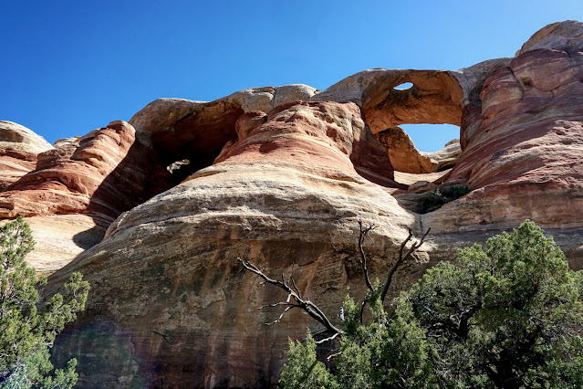


The small perforation, "Leftside Arch," drops a shaft of light into a deep and dark cavity. The alcove entrance mounts up ever steeper. For those contemplating the passage through Cedar Tree Arch, have some fun and test the sticking power of your footfall. (Christian Blackshear, photo)

"Eye Arch" is a 30-foot skylight on the roof of a ground-out, semi-spherical alcove. An irrepressible climber was able to mount the sheer-walled chamber and stand directly under the window.

Monumental and venerable Centennial Arch has a height of 120 feet and span of about 65 feet. The arch is so old it is impossible to know whether it evolved from an alcove or pothole, but there is clear evidence of subsequent development. The cycles of erosion and the vagaries of weather have worked and reworked rock to fashion a testament to Earth's pursuit of beauty. Powerful, architectural columns support the elegant ribbon of stone.
The span is informally known as "East Rim Arch," named by Will Minor, a local sheepherder who wandered McInnis Canyons country for 40 years. He was a storyteller and prolific writer whose columns were published in The Daily Sentinel. In 1993, the U.S. Board on Geographic Names officially designated an arch in Ruby Canyon as Will Minor Arch. (THW, photo)

The wonder of the canyon is ceaseless, enhanced by ever-evolving Entrada forms--stout towers, stacked alcoves, amphitheaters, and solution cavities. On close inspection the sandstone is composed of uniform, fine-grain sands, an indication it was eolian (wind-blown) in origin. Subtle color banding enhances the cross-bedding.

Arches present in quick succession. "Overhanging Arch" is a window on a vault ceiling with an aperture of about 20 feet. We dubbed it "Falcon Arch" because of its bird-like shape and in honor of the 20 bird species ornithologist John Bregar identified on this hike. In particular, we saw and heard numerous Prairie Falcons. Bald and Golden Eagles are common in McInnis Canyons.

Trap Arch formed from a pothole that has expanded to a 30-foot opening. This visually convoluted arch is tucked up high on the north wall of a small amphitheater. It was an irresistible draw for our adventurous lineup. There is no access to the rim from the upper chamber.

If you can get this far up the sheer wall of Trap Arch (Not recommended by this blog!), you'll have no problem scaling through Cedar Tree Arch. Remember, it is riskier to go down than up, and an imperceptible change in slope angle can mean the difference between sticking and sliding. (THW, photo)

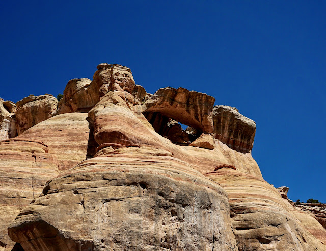
Reach the End of Trail sign at about 4.1 miles where a beautiful view of Cedar Tree Arch ("Rainbow Arch"), awaits. The old pothole arch has an arc lintel spanning 76 feet and a semicircular opening height of 43 feet. Most hikers turn around here, return to the junction with the Upper Trail, and then walk the rim. (THW, photo)

Through Cedar Tree Arch and Rim Walk
Climbers and canyoneers with experience on steep friction slopes may consider scaling two Class 4 pitches to reach the Entrada rim. Having a rope at the ready is recommended. The image below shows the second of three inclines on the first pitch through the arch. A few toe holds gouged into the sandstone assist.

The second pitch leads up onto the rim. In this image, a climber is using the rope secured by the seated individual. (THW, photo)

This image looks down on the second pitch and Cedar Tree Arch.

The lintel of Cedar Tree Arch is unquestionably substantial enough to withstand the passage of hikers eager to cross. If you need to abort the hike, the Upper Trail is a few paces above the rim at Cedar Tree Arch. Turn right to return to the trailhead.

One of the unexpected highlights of this hike was the easy-going rim walk to the northwest, paralleling the Upper Trail. There are literally no obstacles over the next mile. We meandered all over exploring. Stay well away from the cliff edge because it's not always clear which surfaces are overhung.

Please use good judgement when deciding whether to cross an arch. Is it sturdy enough to bear your weight? Below, a daring friend is standing on a pillar on the cliff side of Trap Arch. (THW, photo)

"Falcon Arch" was too thin and vulnerable to carry any of us on its stone wing.

Below, isolated, flat-topped towers rest on the outside curve of an amphitheater. The Lower Trail is visible on the Kayenta bench. Across the canyon, vertical Wingate cliffs overlie the Chinle Formation. (THW, photo)

Viewing Centennial Arch from the rim is riveting and the yearning to fully experience the anomaly takes possession. We sent a light-weight scout out to check the integrity of the span. When she got to the center, there was a crack rendering the structure vulnerable. Out of respect for the Earth itself, we denied ourselves the pleasure of crossing and ask you to do the same.

The photographer caught three friends in a classic stance as they analyze the spell-binding landscape. (THW, photo)

As hikers cross Hole in the Bridge Arch, they pause in turn to look down through the pothole perforating the lintel.

Upper Trail to Trailhead
Soon after passing Hole in the Bridge Arch, at about 5.5 miles, come to the end of the promontory, and stand on the flank of the Uncompahgre Uplift. About four million years ago, the Uncompahgre fault block began to uplift an area from Fruita on the Colorado River to Montrose on the northwest margin of the San Juan Mountains, creating the Uncompahgre Plateau. The image below looks out over the Colorado River and the Black Ridge Canyons Wilderness (75,439 acres), included within McInnis Canyons National Conservation Area (123,430 acres).

You will find the Upper Trail nearby. Hop on it or double back on the rim. Past Cedar Tree Arch, the trail leaves the rim and returns to the Upper and Lower trail split at 6.7 miles. Retrace your steps half a mile southeast to the trailhead.
Addendum
On our second day we did a much bigger hike to Finger Arch and the windows of Mee Canyon. Driving out to the Rattlesnake trailhead, if you know where to look you will see an arch that looks like Centennial's twin on the west rim of Rattlesnake Canyon. On the topo it is 0.3 mile (curving with the rim) south of Point 5,664'. Finger Arch ("West Rim Arch") was the highlight of our arches tour. It is an old alcove arch with a span of about 70 feet. The lintel is roughly horizontal with a thick platform that welcomes all those who wish to cross. The span is suspended well out from the markedly overhung alcove rim.

The other arches we visited were located in an east fork of Mee Canyon. Two Feathers Arch is a young alcove arch. Roof collapse is actively on-going. One feather is clearly visible. The second is tucked up inside the same alcove to the right. (THW, photo)

We strolled up the Two Feathers side canyon for some distance but didn't find more arches. However, we spotted an exquisite penstemon in bloom. (Christian Blackshear, photo)

Crown Arch was the most compelling of the Mee Canyon arches. It is a young and complicated double cave arch, with two, 12-foot spans. Erosion is having its inevitable way. There are massive slabs of exfoliated sandstone in the near vicinity of the arch. (THW, photo)

Tublok Arch was our turnaround. It looks off-kilter and poised to slide from its tenuous hold on the cliff face.
(THW, photo)
