Essence: The thru-hike from Capitol Gorge to Grand Wash is a submersion in exceptional beauty. Marvel at smooth sandstone sheets and the idiosyncratic designs of nearby domes and buttes. Simply attempt to comprehend the wondrous Waterpocket Fold and the grandeur of mountain ranges enfolding the park. This hike is for devotees of Capitol Reef who are familiar with the quirks and hazards associated with its chaotic and labyrinthine landscape. Navigation is the most demanding element of this trek. The off-trail challenge and effort is consistent with what you would expect on the long span between the park's two premier drainageways. We have done the thru-hike in both directions. This description begins from Capitol Gorge because it offers the easier (but longer) route to the Ferns Nipple arena for those doing an out and back. However, there's something to be said for starting the thru-hike from Grand Wash. The most exacting navigation and exposure occurs in the first few miles--is this hike for you? Plus, the Golden Throne Trail is a low-stress finish at the end of a long day.
Travel: The thru-hike requires a short shuttle. Drop a vehicle at the Grand Wash Trailhead and park at the Capitol Gorge Trailhead where the hike begins. Reverse the order if you are starting from Grand Wash. Start early to guarantee parking.
Fruita Campground:
This idyllic, shady campground is adjacent to the Fremont River, tucked
amongst historic fruit orchards. There are bathrooms, fire
grates, picnic tables, and water. You may (and should) reserve six months in advance. Please be sure to cancel your reservations if you are not going to use them. The 71 sites are first-come,
first-serve November through February.Travel: The thru-hike requires a short shuttle. Drop a vehicle at the Grand Wash Trailhead and park at the Capitol Gorge Trailhead where the hike begins. Reverse the order if you are starting from Grand Wash. Start early to guarantee parking.
Fee Information: Park facilities are open year-round.
Distance and Elevation Gain: 10 miles; 2,500 feet (without exploration)
Total Time: 6:30 to 9:00
Difficulty: Trail (2 miles), off-trail (8 miles); navigation most challenging; Class 2+ with one Class 3 move on the final pitch into Grand Wash; moderate exposure; carry more food and water than you think you will need and hike on a cool day.
Maps: Golden Throne; Fruita, UT 7.5' USGS Quads
Latest Date Hiked: Grand Wash to Capitol Gorge, October 25, 2022; Capitol Gorge to Grand Wash, April 11, 2017
Quote: The canyon is like great music, within the reach of everyone and beyond the comprehension of anyone. We can feel it but we can never say it. Charles Bowden
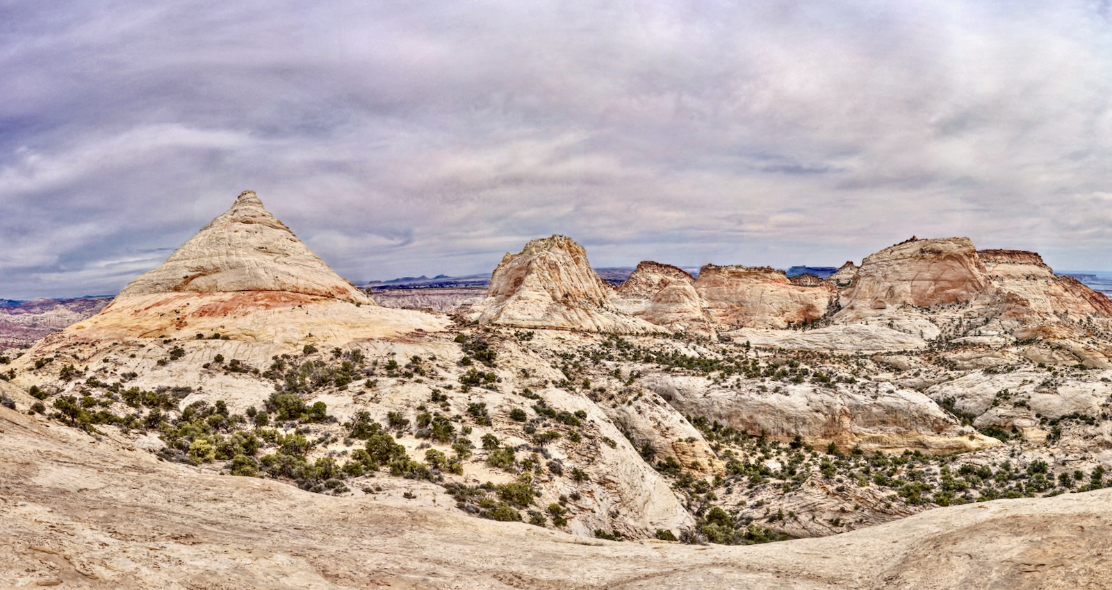
With its perfect conical form, Ferns Nipple is discernible from many locations in Capitol Reef. The prime features of the hike are concentrated in the surrounding locale--whether you are free-ranging amongst the buttes at the head of Bear Canyon, or climbing Ferns Nipple--Class 5 with serious exposure. (Thomas Holt Ward, photo)
Route: For legibility, two maps are presented. While this description begins in Capitol Gorge and goes south to north, the route may be reversed. From the Golden Throne Trailhead, hike roughly northwest to the end
of the trail. Head north along the west side of Golden Throne and then
up a sandstone ramp to the west end of a ridge extending from Point 6,694'.
Walk north-northwest in a drainage to the highpoint of the hike, 6,940 feet. Hold that trajectory and climb over Dome 6,860' to Ferns Nipple.
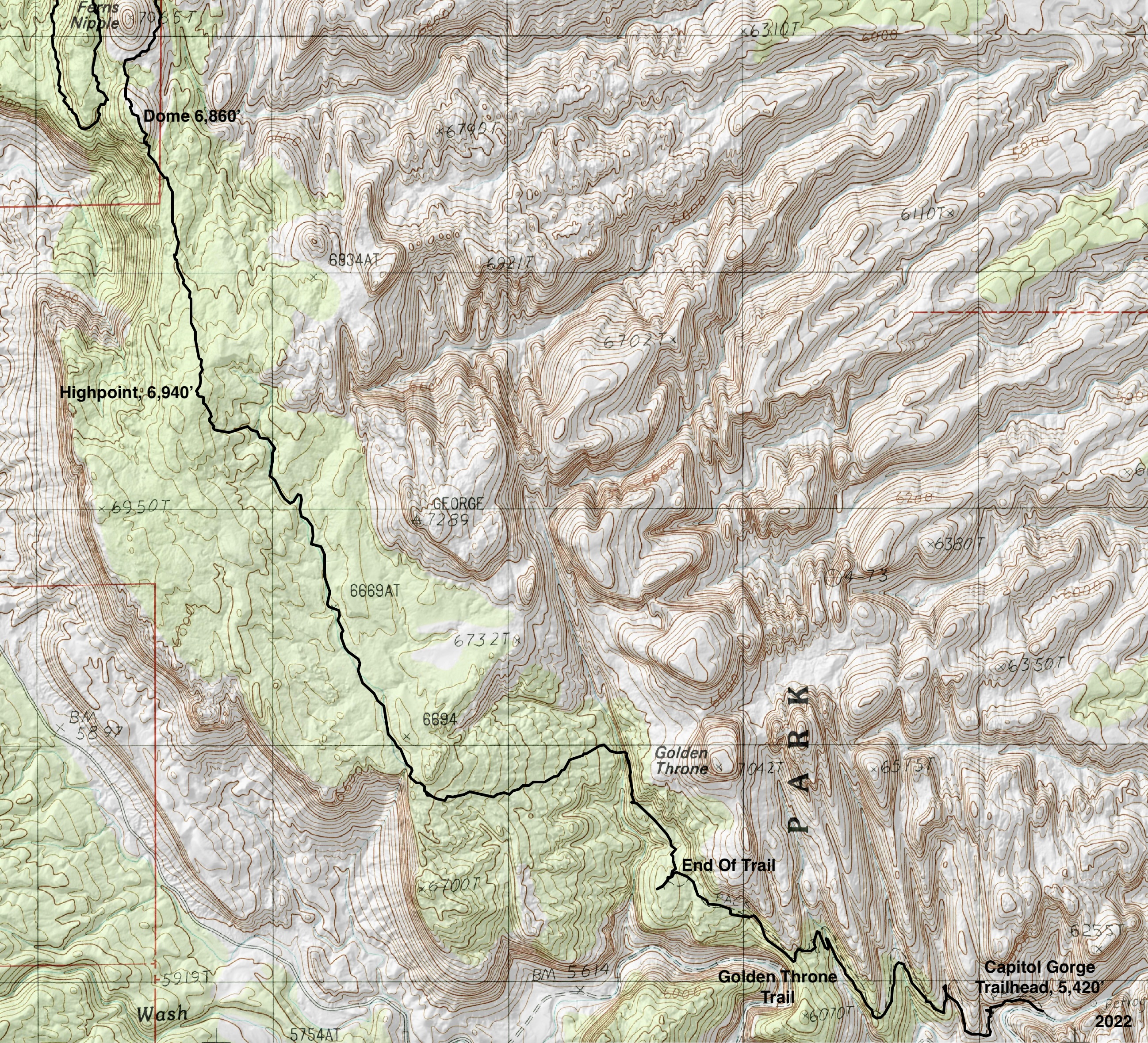
Swing around the north slope of Ferns Nipple and descend south in a broad gully. Round the south end of a ridge and hike north on slickrock benches high above Shinob Canyon. Wind in and out of three, unnamed side canyons. A cairned social trail picks up north of the middle side canyon. Follow cairns into Bear Canyon and on down into Grand Wash. Walk upcanyon to the trailhead.

Golden Throne Trailhead (Capitol Gorge)
The Golden Throne and Capitol Gorge trails leave from different
locations in a shared parking lot, elevation 5,420 feet. Start up the Golden Throne Trail on Kayenta Formation walking ledges pitched at just the right degree for a gradual, consistent ascent. The well-engineered trail weaves between enormous fallen sandstone boulders. Be engulfed in rock--everything is massive. Geological features to watch for are iron concretions flung about the surface, tafoni (cavities in the walls), and mustard-colored Liesegang rings. The popular footpath winds in and out of three, sheer-walled crack canyons. Living on soil-generating ledges are
piñon-juniper, roundleaf buffaloberry, and ephedra.
Blooming in the spring are Utah penstemon, rockcress, paintbrush,
puccoon, cat's eye, and woolly milkvetch. (Please note that the photos used in this post were gathered on many hikes over the years so the skyscape varies.)

The Golden Throne trail ends at 1.9 miles, elevation 6,120 feet. The
overlook is 0.1 mile to the west. With its smooth, vertical walls cloaked in yellow
the Throne is a marvel. To its north are three flat-topped, cliff-bound
buttes. The first two are unnamed and unnumbered. George Benchmark is image-left.

Ferns Nipple
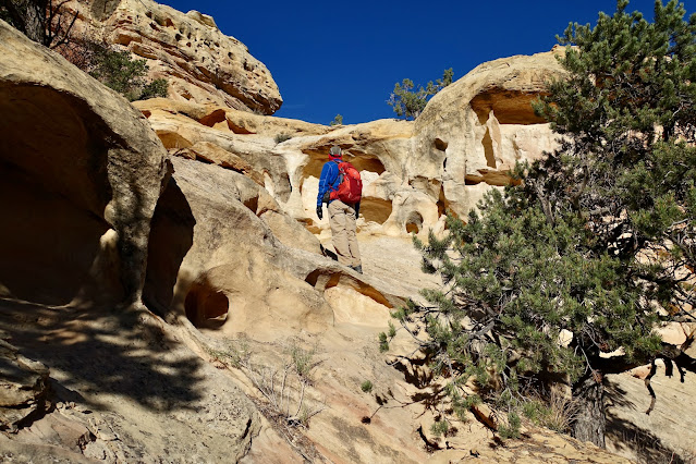
The next navigation objective is the west side of a knobby ridge, image-left. From the end of trail sign, strike out northward on a social trail. The path is a little obscure at first but it quickly becomes more distinct. Throughout the hike, do your best to stay on a use trail or open rock, and avoid stepping on
cryptobiotic soil. The route hugs the west wall of the Golden Throne, pinching between the escarpment and a sharp drop.


Over time, water gushing from the crack between the buttes has carved a fluted channel, pouroff, and pool.

At 2.4 miles reach the (normally) dry streambed just above water-scoured tanks that head the barrier fall. The social trail vanishes and the remainder of the journey will likely be one of solitude. (THW, photo)

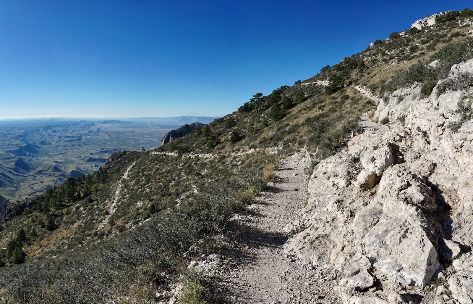
Walk up the drainage about 50 feet and then take a few steps up out of
the wash onto an appealing slickrock incline. Hike west, ascending 500 feet over 0.6 mile to rim's edge. It is possible to thread together slickrock runners and ramps the entire distance. (THW, photo)

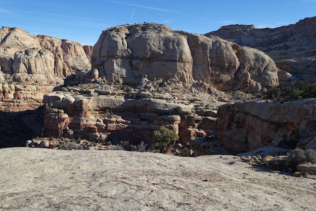
Reach the west end of the ridge extending from Point 6,694' at 3.0 miles. Pause on the vast slab to look back one last time on the Golden Throne with its 500-foot earth mural. Mount Ellen in the Henry Mountains is one of 57 peaks in the Lower 48 with 5,000 feet of topographic prominence. (THW, photo)

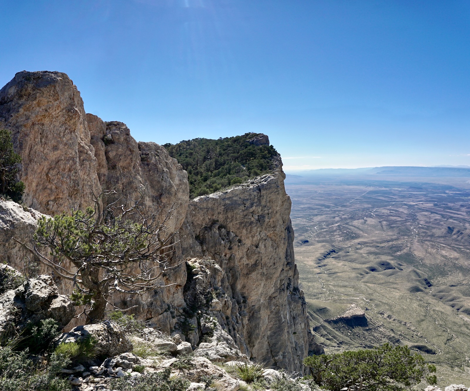
There are plenty of cliff edges on this trek but none compare with the radical 800-foot drop to Scenic Drive. The rim is held up by cliff-forming Wingate Sandstone and thin bands of Kayenta Formation.

The route turns north alongside an impossibly high pouroff. Step into the arroyo beyond the dry fall. The route utilizes nature's pathway for 1.2 miles bearing north-northwest. The wash is brush-free, sandy, and peaceful. Elder juniper, rabbitbrush, and snakeweed surround.

Take the left fork when the wash splits at 3.3 miles. In October, 2022, we followed the prints of an adult bear and two juvenile cubs for the next mile.

The wash splits again at 4.3 miles. Turn west into a secondary drainage. In about 0.1 mile turn out of the streamway and go north onto a subtle east-west running rise. The high point of the hike is on a 6,940-foot knoll at 4.6 miles. One of our favorite adventures in the park is climbing nearby George Benchmark, 7,289', the highest prominence in the region. The knoll affords the first look at Ferns Nipple, a mile away and a straight shot north.

Walk on compacted soil with a crushed rock surface through a piñon-juniper woodland. Scattered on sheets of sandstone are captivating, odd-shaped organic forms--"egg rock." (THW, photo)

The route goes up and over the dome south of Ferns Nipple, image-left. In 2017, the friction pitch on the south side gave some of my friends pause. But it is a perfectly safe climb to the top of the dome at 5.5 miles, 6,860 feet.

From the rounded crest, Scenic Drive is now 1,000 feet below. Vast, timbered, and low-slung, Miners Mountain contributes water into both Capitol Gorge and Grand Wash (separated by the Slickrock Divide). Rising high in the west is Bluebell Knoll on Boulder Mountain, 11,340'.

The surface of the dome is adorned with beige moqui balls and chunks of highly textured lavender-colored rock. Please tiptoe around them and resist all urges to pocket what was birthed here and deserves to live on this dome! (THW, photo)

Alight on the south bench of Ferns Nipple at 5.7 miles. Brilliant Navajo Sandstone dazzles in shades of purple, yellow, mustard, and red.

Alight on the south bench of Ferns Nipple at 5.7 miles. Brilliant Navajo Sandstone dazzles in shades of purple, yellow, mustard, and red.

For me, the finest part of the hike is concentrated in this glorious slickrock world surrounded by multiple buttes with fantastical shapes. We explored east into the upper reaches of Bear Canyon. Reportedly there is a route down Bear that links with Grand Wash. In the spring of 2022, we attempted to go up Bear Canyon from Grand Wash but got turned around at a pouroff. Without a successful trip up, we weren't about to attempt an exit from the head of the canyon.
In 2017, I started up Ferns Nipple from the north side with friends. I
bailed after just 100 vertical feet up the 325-foot rise. The climbing wasn't difficult but I couldn't tolerate the absurd exposure. After a successful climb, some needed a handline for the descent. Carry one.

Ferns Nipple to Grand Wash
Those who are simply visiting the Ferns Nipple region should retrace steps to Capitol Gorge. For those doing the thru-hike, it is four miles from the north side of Ferns Nipple to the Grand Wash Trailhead. For reference, it took us three hours to cover the stretch from Capitol Gorge and almost an hour longer for the north segment. To begin, walk north on a rather narrow rim hugging up against Fern. Weathered blocks are poised to slide off the east slope.
(THW, photo)

Iron concretions are abundant on this side of the butte.

Descend around to the north and west (shown) until you can drop into the gully that runs south along the west skirts of Ferns Nipple. Our route points south for half a mile before turning back to the north. Note: There is an alternate, shorter route from the north slope of Ferns that drops radically into the most southern of the three side canyons in Shinob Canyon. Reference Road Trip Ryan for an excellent description of the Ferns
Nipple climb from the Grand Wash approach. Please consult the trip report before attempting this more challenging route. (THW, photo)

Finagle a way down through the gully. The step-down is a fun little scramble. There are multiple threads; we've worked all of them. The exit from the canyon is at the bright, sandstone landing, image-center. (THW, photo)

This image looks back upcanyon from the exit location.

Critical: you must be transitioning out of the gully by 6,560 feet. Curve west under the south end of the ridge, shown. Below, my partner is doing the hike from Grand Wash and is about to enter the gully.

Hold a north bearing while working broad, slickrock ledges. My field notes gloat over this stretch. There are no cairns--employ the intuitive route, descending all the while. The deep rift forming to the west is Shinob Canyon. It is not named on the Fruita topo but it is referenced on other maps. (THW, photo)

The route winds in and out of three side canyons. To keep them straight I've labeled them on the map as "South," "Middle," and "North." I have been over this stretch four times and commandeering the first two side canyons is the most difficult part of the hike for me. Side Canyon South is complicated by massive boulders in the channel. It is hard to get down in there, but then I tend to approach too high. Cross at about 6,160 feet. This image looks into the canyon from the north. Road Trip Ryan's shortcut to Ferns Nipple begins in this canyon.

Crossing Side Canyon Middle (south of Point 6,309') is dicey. The approach into the canyon is steep but reasonable from the south. In 2022, cairns marked a passage for a crossing at about 6,000 feet. In the past, a social trail led from the creek bed onto a comfortable ledge on the north side, shown.

I have crossed the canyon three times with little difficulty. However, the trail was blown away by a flash flood in June, 2022. The slope on the north side is washed out and trenched, shown. It is composed of rounded rubble balls pitched at the angle of repose hanging above a no-exit plunge. Simply do your best to find a safe place to cross. Figure you are going to drop some time while picking your way to safety. Below, my partner is entering the side canyon from the north.

A well-cairned social trail picks up on the north side and is reliable (and indispensable) all the way to Grand Wash. Capitalize on the slickrock pathway rounding Point 6,309'. Below, straight walled, brick and white striped Shinob Canyon joins forces with Grand Wash.

Side Canyon North is delightful, easy going, and shallow. Take a final look back at Ferns Nipple while leaving Shinob Canyon behind and rounding the corner into the Grand Wash corridor.

Stand on the last expanse of Navajo Sandstone while taking in phenomenal views of Waterpocket Fold and Thousand Lake Mountain. The image below captures groups of people visiting Cassidy Arch drilled into the garnet-colored Kayenta Formation.

Activate your navigation wizard for the 340-foot descent into Bear Canyon. You will be crossing Bear just above its pouroff into Grand Wash. The photo below was snapped from a landing at 5,900 feet, 1.0 mile from the end of the hike. The next objective is the platform across Bear Canyon, image-lower-left.

From the landing, hang a hard left into the gray chute, shown, and scramble down the crack.

Punch down through complicated terrain troubled with cliffs. Follow cairns religiously. You will never guess your way. The route wiggles and weaves, threading from one tiny break in the cliffs to the next. Meander on shelves between weaknesses, shown. Churning down the hillside on this magic path is great fun...provided you don't lose your way. If you lose sight of the cairns, return to the last known one and locate the next before continuing.


Pass through a small stone bowl, its surface riddled with eroded forms and recesses.

Cross Bear Canyon at 5,560 feet, over the top of a beautiful but impassible pouroff. The final passage to the Grand Wash floor is a lengthy bypass of this obstacle. This image looks back on Bear Canyon.

The Bear Canyon platform is just 0.5 mile from the end of the hike.

The drop into Grand Wash is the final challenge. Over time, the unmaintained social trail has improved from braided and haphazardly cairned to distinct and
well marked. It's fun to puzzle out the route as it descends the hillside riddled with large, fallen boulders and thin cliffbands. This is the most exposed portion of the hike. Getting past the crux point is mandatory in order to transition to the next lower level. Below, my partner has just left the platform and is about to reach the crux.

The low Class 3 move is assisted by a small piñon tree growing in a crack.
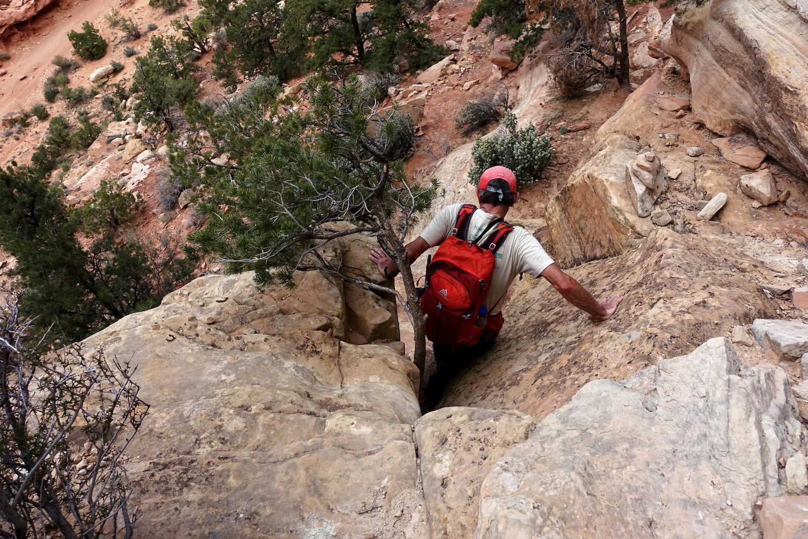
This image looks back at the tree crux on the left. Exposure is moderate and the holds are good, thanks to the little tree. Be gentle with it. (THW, photo)

The route threads from one ledge to another with well-cairned step downs. Arrive on the floor of Grand Wash about 100 paces downcanyon of the Cassidy Arch Trail. The junction is sometimes marked with a cairn on the east side of the canyon. Walk up the watercourse 0.25 mile to the Grand Wash Trailhead, 5,420 feet.