Essence: This trek traverses the Peak 4,416' divide separating Wild Burro and Cochie canyons at the southwest end of the Tortolita Mountains. Climb Peak 4,416' and then explore three additional unranked points. While Peak 4,416' is suitable for all strong hikers, the traverse alternates between magical and painful. Slashing cactus literally destroyed our jeans. This photo-rich post is intended to show off the wondrous weathered stone statuary strung along the ridge. The journey is suitable for intrepid adventurers with a high tolerance for ferocious brush. I suggest exploring the Peak 4,373' divide first to see whether hiking off-trail in the Tortolita Mountains is for you. Approach the ridge via three trails within a vast network admirably engineered and maintained by the city
of Marana.
Travel: The hike begins from the Wild Burro Trailhead, 14810 N. Secret Springs
Drive. Measure distance from Twin Peaks and Tangerine roads. Twin Peaks
becomes Dove Mountain Blvd. at the intersection. Go north on Dove
Mountain. At the
traffic circle at 4.5 miles, take the first right, staying on Dove
Mountain. At the Ritz Carlton gatehouse, tell the attendant you will be
hiking. In another 0.7 mile, turn right and then make an immediately right into the large dirt parking lot. Restroom and drinking faucet, no
fees. Maps are available at the trailhead.
Distance and Elevation Gain: 9.2 miles; 2,200 feet. The difficulty of this hike is not accurately reflected in the statistics.
Total Time: 7:00 to 9:00
Difficulty: Trail, off-trail; navigation moderate; Class 3 with mild exposure north of Little Caprock Peak; hike in winter months and carry all the water you will need. Dress defensively.
Maps: Ruelas Canyon; Tortolita Mountains, AZ 7.5' USGS Quads
Date Hiked: January 22, 2023
Quote: One further freedom, turn me please to stone. José Knighton
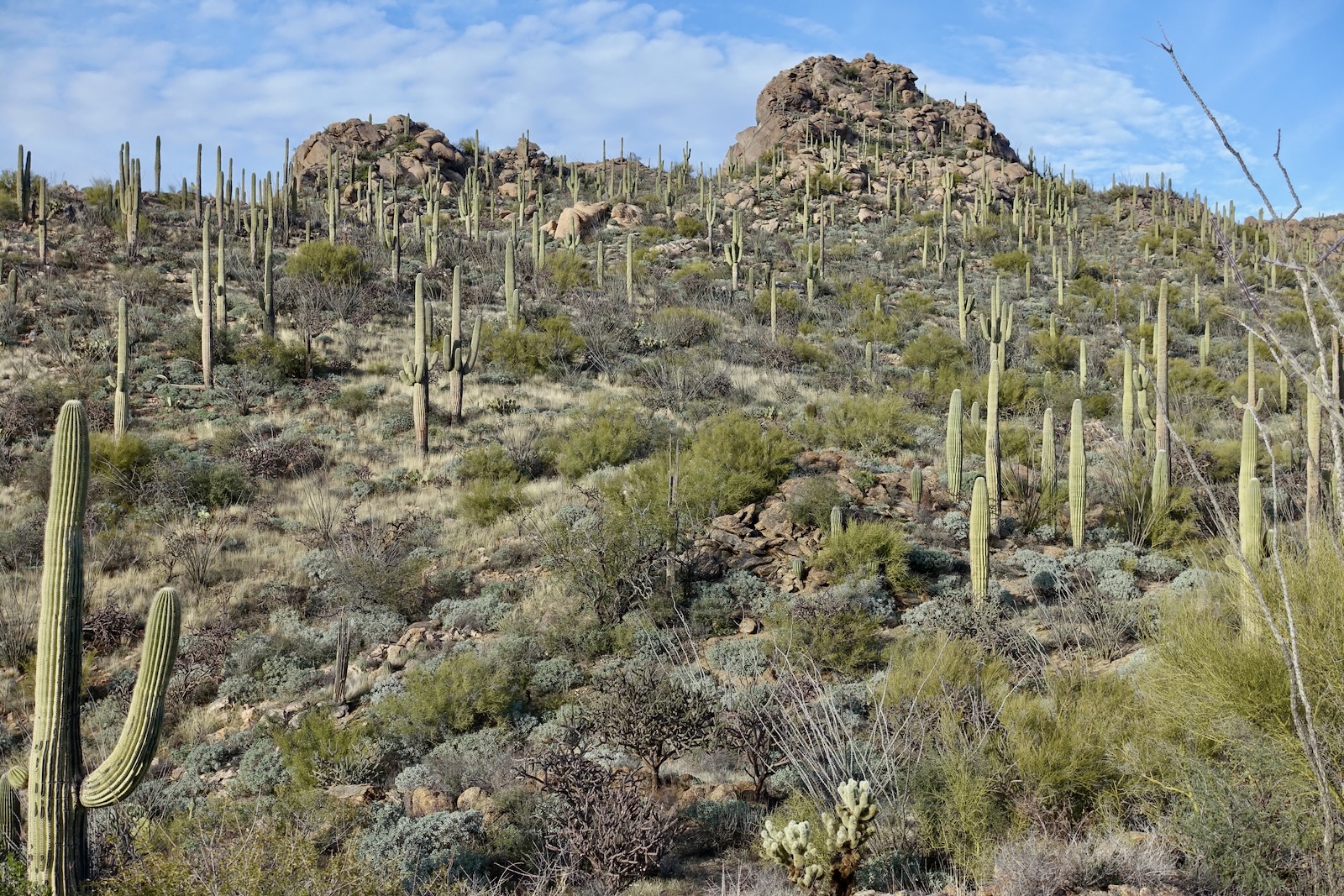
The traverse renders an uncommon perspective on familiar landmarks. From the south, Peak 4,416' and its subsidiary summit appear as one. (Thomas Holt Ward, photo)

Route: Walk northeast up the Wild Burro Canyon wash and link with the Upper Javelina Trail bearing northwest. Turn northeast on the Wild Mustang Trail. Segue onto a social trail heading north and west to Peak 4,416'. Proceed off-trail southwest over Point 4,279', Point 4,161', and Little Caprock Peak. Descend south and close the loop on the Wild Mustang Trail. Note: the Ruelas Canyon topo has 20-foot contour intervals and the Tortolita Mountains quad has 40-foot intervals.

Peak 4,416'
The trailhead for the Wild Burro Trail is on the south side of the parking lot adjacent to the restroom, elevation 2,800 feet. Walk down the ramp and head northeast up the wash. Or, if you wish, follow the Wild Burro Trail as it crosses back and forth over the waterway. Ambling in the wash on granular sand is effortless. (THW, photo)

In half a mile you'll come to a major trail junction. Go left/northwest on the Wild Burro Trail. The cholla habitat is remarkably diverse, the plants maxed out in stature. Pricklypear are magnificent as well. In a tenth of a mile at the signed junction, leave the Wild Burro Trail and head uphill on the Upper Javelina Trail. Travel through a land of spheroids. The superbly crafted trail is so fun it'll make you giddy. Step up on boulders embedded in the trail while mounting a ridgelet. Pitch down into a draw, Climb again on tight switchbacks. Step up a stone staircase enclosed by rock runners and bruiser saguaros. Crest a small ridge north of Point 3,186'.
What's the creation story behind the highly textured rounded boulders? They are 600-million-year-old Tortolita Mountains Granite. Look around and you'll see examples of pegmatite--extreme intrusive igneous rocks with exceptionally large crystals. (Intrusive rocks are formed from magma that cools and solidifies within the crust of the planet.) The range is a northwestern extension of the Catalina
Metamorphic Core Complex
which makes up the Santa Catalina Mountains. The granite was birthed in the Crystalline
Basement and emerged
from beneath the crust by tectonic forces roughly 18
million years ago. Over the eons weathering processes smoothed the edges
and corners to create the spheroids.

At 1.6 miles, leave the Upper Javelina and transition to the Wild Mustang Trail. Views are far-reaching from this junction. Pass by the Cochie Springs Trail at 1.9 miles. The range is known for its abundance of crested saguaros. We counted 22 on our first hike in 2015. Watch for the fan-shaped cristate below the trail at 2.1 miles. (THW, photo)

There is a whole community of elder saguaros on the Wild Mustang Trail. (THW, photo)

At 2.4 miles, 3,580 feet, arrive on a natural platform with a bench and two informative placards. (THW, photo)

To the east we could see the companion divide we explored five days prior: Peak 4,373', Point 4,070', and Peak 4,053'.

Swinging around to our intended ridge, we speculated
this might be a good place to close the loop. Indeed, at the end of the traverse we descended from the knoll image-left.

The trail parallels the Peak 4,416' divide. Some of the primary stone features on the ridgeline are visible from the footpath. It ascends west of slab-riddled Point 4,169'.
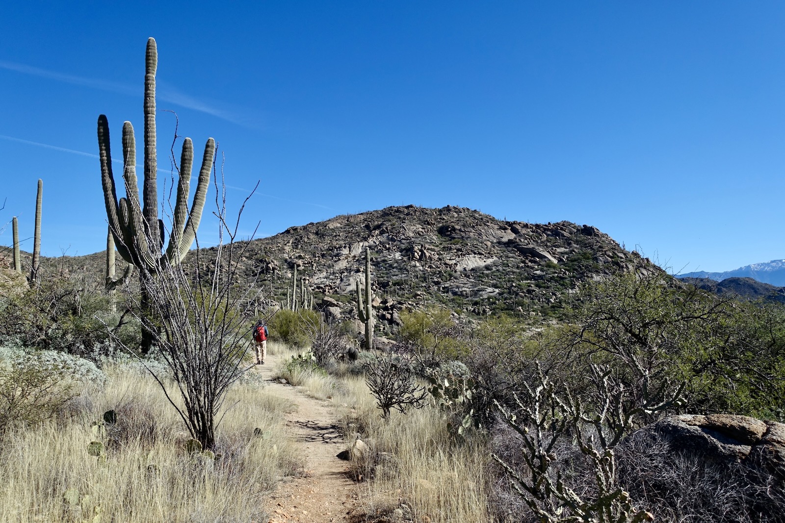
On our first visit in 2015, we took one glance at mesmerizing Peak 4,416' and its subsidiary at 3.6 miles and began looking around for a route up. Stay on the trail for another 0.4 mile. (THW, photo)

You are closing in on the social trail to Peak 4,416' when you pass remarkable, gigantic spheroidal balls perched on a stone slab east of the trail. Give up a few feet and at 4.0 miles, 4,080 feet, go left onto a social trail bearing north. In 2023 there was a gateway cairn five feet up the path. Track along the base of two rollers.

At 4.3 miles a gateway cairn signifies a faint trail splitting off to the right and heading down into Cochie Canyon. "You have to know its there." We ran into five locals who said the path linking the Wild Mustang and Cochie Springs trails was built by three men. The combined initials of their first names spells "JED." And that is the origin of the common informal name for Peak 4,416'. The heavily cairned trail to JED Peak cranks southeast here and ascends to a small saddle south of the mountain.


At the saddle, the route turns due north and makes for the summit. Boulders are laid out in slabs on the surface of this alluring mountain. For hikers accustomed to trail walking, give this final pitch a shot. It's Class 2+, meaning you'll use your hands to steady yourself. But the rock is sticky and you are unlikely to slip. It's just a fun scamper. This is a mountain that wants to be climbed.

Resurrection moss flows over stone. Also known as spikemoss, after just a few hours exposed to moisture, the desiccated plant unfurls and turns bright green. (THW, photo)

I found it truly thrilling to be skimming up granite, so solid and dependable underfoot.


Alight on the summit platform at 4.6 miles. The apex is a pile of spheres. The highest boulder is just three feet in diameter. Standing on the zenith can be a little dicey. If you glance through the peak register protected in an ammo box, you'll learn that the mountain has two unofficial names: JED and Big Caprock Peak.

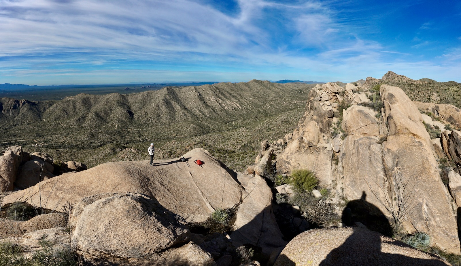
With a rise of 516 feet, the views are expansive. Jeffords Peak, the highest prominence in the Tortolita Mountains at 4,696 feet, is image-left. The multi-monolithic west wall of Pusch Ridge rises east of Oro Valley. And, of course, lofty Mount Lemmon rounds out the horizon.

Be sure to check out the neighboring stone stack with its comfortable standing slab.

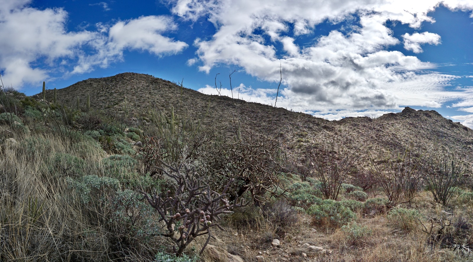
The stack affords an excellent view of the southwest ridge. Our plan was to explore the ridge, going over Points 4,279' and 4,161'. We discovered Little Caprock Peak at the far end and climbed it too. The stone features were more magnificent than anything we could have imagined. But so were the challenges, especially the brush. This traverse is for off-trail desert specialists.
For those turning back from Peak 4,416' you have two (or more) choices. You can simply return to the trailhead as you came--the most efficient route. Or, you may reprise our 2015 circuit. We retraced steps to the Wild Mustang Trail and walked northeast to the junction with the Wild Burro Trail. We followed it all the way back to the trailhead for a total of 10.3 miles, 1,900 feet of elevation gain, 6:00 hours.

Point 4,279'
We didn't explore staying on the ridgeline coming off Peak 4,416'. Big monster boulders looked impossible to negotiate. In retrospect, we wished we had tried. There might have been a way. Instead, we took the standard route back to the little saddle. From there, getting over to the ridge was troubled with prickly brush. We looked for a scramble up the subsidiary outcrop, shown, but didn't find one.


We contacted the ridge south of the subsidiary. The free-standing sentinel was so majestic I wanted to get my hands and feet on it but, no way. (THW, photo)

The idea, of course, was to climb everything we could along the irresistible linear neighborhood. South of the subsidiary a wedge thrusts westward.

We played around on its stone essence. (THW, photo)

Our next destination was Point 4,279'.

The ridgecrest was glorious when we could stay on it. Brush was inconsequential, bedrock and resurrection moss were plentiful.

It was intoxicating spanning to Point 4,279'. We were so fortunate to find a slim passage under an overhanging boulder. We worked the edge of possibility and lit on the square-block crest at 5.1 miles.

Point 4,161'
The image below was shot from Point 4,279'. The topography grows more complex. We climbed three knobs between the two numbered points. We found our way intuitively, just doing the best we could given the brush impediment and gendarmes. When we were thrown off the ridgetop the catclaw and yucca were downright discouraging. There were enough sweet
spots to make up for the "Ouch!" (THW, photo)

Point 4,161' and Little Caprock Peak visually separated into two entities as we closed in.

Point 4,161' threw up a formidable barrier wall in our path. This monster was the most imposing and impressive of all. We found a weakness at the east end of the escarpment. It was choked with tortuous brush but it worked--call it a common miracle. (THW, photo)

We sneaked around and arrived in a trough between Point 4,161' and its companion stack. This rapturous corridor was surely the best place on the ridge. But wait. It gets even better.

At 5.9 miles we were standing on a sweeping swath of dazzling stone...searching for a workable pitch to the top. My partner started up a shallow crack. He cut loose crystals from the bedrock indicating climbers hadn't been there. It was too risky without a spot for the downclimb. So no, we didn't summit.

We were consoled by the fun scramble up the opposing standing stone.

From the lofty perch, the boldness and sheer power of the stone creatures on this humble divide was apparent.
(THW, photo)

Little Caprock Peak, Point 4,110'
Looking south we realized we hadn't played out the ridge. There was yet another distinctive prominence we knew nothing about. It doesn't draw attention to itself on the topo. We couldn't resist, so onward.

The span on the summit block was Class 3 with one brief exposed section on the razorback ridge. If you've gotten this far, you can top out on Little Caprock Peak at 6.2 miles. The Ruelas Canyon quad is a little wonky but standard approximation pegs the elevation at roughly 4,110 feet. We were completely blown to find a peak register placed in 2008 by The Grinning Bighorn. He (or she!) gave it the highly illustrative informal name. Only a couple of subsequent parties signed the register. The last outcrop on this indomitable ridge was clearly a bird aerie.

Paying homage to The Grinning Bighorn, this image takes in the entire span between Big and Little Caprock Peaks. (THW, photo)

We worked our way down the ridge staying as close as we could on the east side. Cairns led onto a 40-foot knife-edged boulder. I'm bummed we didn't see it until we were below. A string of cairns appear to guide down a subtle lateral ridge to the trail. Surely that would have worked. But we corrected to contact the knoll we'd seen from the trail. We closed the loop at 6.8 miles on the platform with the resting bench and placards. Little Caprock in all its ramshackle glory was in plain sight.
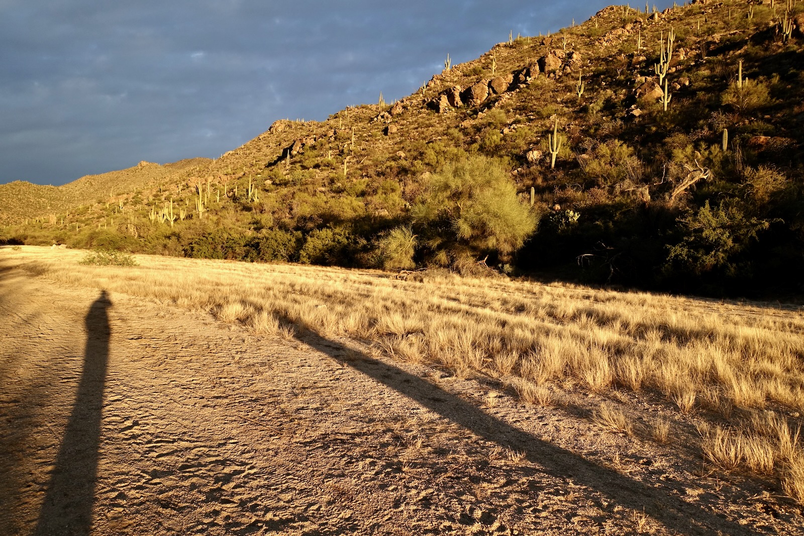
Wild Burro Wash was iridescent on our January evening. And now that we knew where to look, we could see Little Caprock Peak, object of great affection, from trailhead parking.