Essence: Climb three ranked limestone peaks on the western perimeter of the Santa Rita Mountains. The summits are lined up on a northwest to southeast running ridge separated by deeply incised drainages. Each hike is short with minimal elevation gain--tackle all three in one day from separate parking areas. Devils Cash Box and Peak 5,012' are Class 2 walk-ups. Peak 5,359', informally named Devils Throne, is exposed Class 3 and should be reserved for experienced desert mountaineers. Each hike is on public land managed by Coronado National Forest. The mountains (and traveling instructions) are detailed in this post in the following order: Devils Cash Box, Devils Throne, and Peak 5,012'.
Distance and Elevation Gain for Three Peaks: 5.5 miles; 2,900 feet
Map: Mount Hopkins, AZ 7.5' USGS Quad
Date Hiked: December 11, 2024
Song:
Map: Mount Hopkins, AZ 7.5' USGS Quad
Date Hiked: December 11, 2024
Song:
Pleased to meet youHope you guess my nameBut what's puzzlin' youIs the nature of my game.
The Rolling Stones, "Sympathy for the Devil"
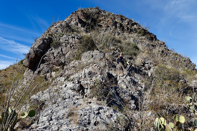
Each of the "Three Devils" look virtually impossible from a distance. Approached correctly, Devils Cash Box and Peak 5,012' are obtainable for all hikers comfortable traveling off-trail in the Sonoran desert. For experienced scramblers Devils Throne, shown, will likely be the thrilling favorite. (Thomas Holt Ward, photo)

Route
Route
Devils Cash Box: Begin by walking southeast on FSR 4077. Leave the road and gain the northwest ridge. Hike on the ridgeline to the summit.
Devils Throne: Bear east on FSR 184B, then south on FSR 184C. Leave the track and flank UN 5,180' bearing due west. Climb the east ridge to the crest.
Peak 5,012': From the Whipple Observatory Visitor Center, walk up the Mount Hopkins Road a short distance. Hike off-trail on the curving southwest ridge of the mountain.

Devils Cash Box, 4,964'
Essence: Who could possibly resist climbing a peak with such a curious and creative name? I dug around but could not find a note on the name's origin. (Please leave a comment if you know.) This is a short and sweet little warmup hike. Positioned at the northwest end of the ridge and possessing a rise of 464 feet, there are good views north to Elephant Head and east to much higher peaks on the western front of the Santa Rita Mountains.
Travel: From Tucson, drive south on I-19 passing the town of Green Valley. Take
Exit 56, Canoa Road. Start measuring from the bottom of the ramp. In
the rotary, go around and under the freeway. At the stop sign turn south
on the frontage road. At 3.2 miles, turn left on Elephant Head Road.
Turn right on paved Mount Hopkins Road at 4.7 miles. At 10.3 miles, go left on
FSR 183. Drive just 0.5 mile and turn right onto FSR 4077. Park in a large pullout on the left just before a sign for 4077. 2WD vehicles with decent clearance should be adequate on FSR 183.
Distance and Elevation Gain: 1.7 miles; 950 feet
Total Time: 1:30 to 2:00
Difficulty: Off-trail; navigation easy; Class 2 with no exposure; some brush, wear long pants; hike in the cool months and carry all the water you will need.
Total Time: 1:30 to 2:00
Difficulty: Off-trail; navigation easy; Class 2 with no exposure; some brush, wear long pants; hike in the cool months and carry all the water you will need.
From a distance Devils Cash Box looks precipitous and daunting. But get up close and the effort becomes more clear--it's just a mellow ridgeline hike.
From parking, elevation 4,040 feet, Elephant Head shows off his might. While standing on the summit for the first time in 2012 I took a good look at Devils Cash Box and chalked it up as impossible. I'd like to thank Sarah Simon for her compelling SummitPost entry for Devils Cash Box. We can do this!

Walk southeast up FSR 4077. Two things of note. The mammillaria was in fruit. As my friend observed, if you see it in the garden store you don't think much of it. But see it in the raw desert and it thrills you. It pays to have keen, alert eyes. The road was covered in mountain lion tracks. There is a small pullout on the right a quarter mile in. Leave the road and take a subtle and rubbly social trail west to the ridge. (When a footpath is barely visible, we often call it a wildcat trail. How appropriate.) Below, the path is just left of the paloverde tree.

Gain the ridge at 0.3 mile, 4,220 feet. Shooting north, my partner is standing at the intersect on the ridge.

We headed up the northwest ridgeline. To begin, we were able to dodge the shindaggers and ocotillo, no problem. (THW, photo)


I was taken by surprise to be walking on broken limestone. I expected to find the granitics that compose nearby peaks.

The surface is covered with limestone boulders impregnated with chert nodules.

The hike is so short, no matter where you pause to check out the summit, it's close by.

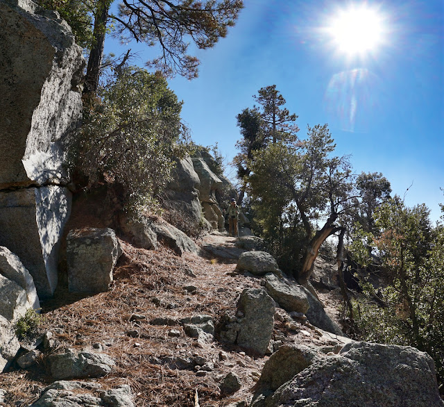
At 4,700 feet we came naturally alongside the cliff edge and hovered near the precipice clear to the top. You can moderate how close you are to the drop. (THW, photo)

Higher on the mountain there is more brush dodging and bashing. Walking up the boulders on the ridge top is wildly pleasurable. The karst on their surface is razor sharp. (THW, photo)

Peak 4,964' is not the highest summit on the Devils Cash Box ridge but it is so named in Lists of John. Top out on the mountain at 0.85 mile. The crest is roomy and there are plenty of good sitting stones for taking in the sweeping vista. (THW, photo)

In the north Yoas Mountain and Peak 4,259' are the cone-shaped diminutive summits west of Little Elephant Head and Elephant Head.

There is a seldom seen perspective on the golden rolling foothills below the observatory on Mount Hopkins. Tree clad Pete Mountain (The peak without a decent view.) is image-left.
Look down on the Fred Lawrence Whipple Observatory Visitor & Science Center and southeast to Peak 5,012' and Devils Throne.

The circular cloud above Baboquivari Peak is a mystery of the desert. Perhaps it was the contrail from a military jet on a training
mission that just happened to follow a circular path at the right
altitude. Surface rubble makes the footing on the descent a little slick. It requires a bit more concentration than on the trip up. (THW, photo)

Devils Throne, Peak 5,359'
Essence: Devils Cash Box and Peak 5,012' are hikes. Devils Throne is a climb requiring Class 3 scrambling skills and a tolerance for exposure to falling. It was a good call to put the Throne second in the lineup so we climbed it when fresh. It is another short hike with minimal vertical but it has other challenges.
Travel: From Tucson, drive south on I-19 passing the town of Green Valley. Take
Exit 56, Canoa Road. Start measuring from the bottom of the ramp. In
the rotary, go around and under the freeway. At the stop sign turn south
on the frontage road. At 3.2 miles, turn left on Elephant Head Road.
Turn right on paved Mount Hopkins Road at 4.7 miles. The Fred Lawrence Whipple Observatory Visitors Center will be on your right at 11.3 miles. The paved road turns to dirt. Half a mile past the Visitor Center turn right onto a narrow road, FSR 184B. It is rough and rutted right from the start. 2WD vehicles should park at the turn. We proceeded
to the first pullout on the left 0.1 mile up the road. Dedicated 4WD vehicles could continue another 0.5 mile to FSR 184C.
Distance and Elevation Gain: 2.6 miles; 1,100 feet
Total Time: 2:00 to 2:30
Difficulty: Trail, off-trail; navigation moderate; Class 3 with moderate exposure
Distance and Elevation Gain: 2.6 miles; 1,100 feet
Total Time: 2:00 to 2:30
Difficulty: Trail, off-trail; navigation moderate; Class 3 with moderate exposure
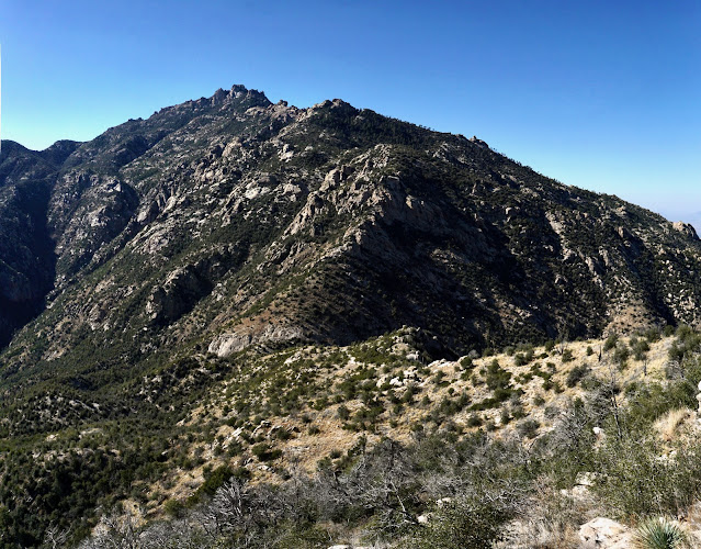
Check out the north face of Devils Throne from Peak 5,012' and it is obvious how the peak got its informal name. The Throne is climbed from the south ridge. 
From the parking pullout at 4,360 feet walk east up FSR 184B. If you wish to drive up this road be aware that there are no turnaround opportunities before the junction with FSR 184C and the surface is deeply trenched in places.

At 0.5 mile,
4,560 feet, turn sharply south onto FSR 184C. There is the typical shortcut just prior to the turn which works fine.

There were some OHV tracks on the rough road that served the Montosa Mine.

We had to get past Point 5,133' before we could get a look at Devils Throne.

The first visual of Devils Throne was fierce and intimidating. I had to dig down and remind myself that the rule is to get on the rock before making a judgement about feasibility.

At 0.95 mile,
4,940 feet, gain the saddle east of unnumbered Point 5,180'. The next objective is the base of the east ridge of the Throne. The easiest strategy is to flank UN 5,180' on its north. Segue onto a social trail at the saddle heading due west. It's handy to begin.

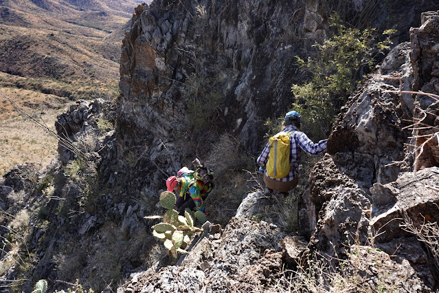
The trail became fragmented. Sometimes we were on it, often not. The brush was thick but the side slope is not difficult and the passage is short.

Arrive in the saddle below the south ridge at 1.1 mile, 5,020 feet. We felt our way up the mountain just as you will and I'm certain there are other viable routes. Following is an overview of what we did. We started out going up the center of the ridge. Upon reaching a rock rib we jagged right and entered the chute that's in the shadows. At the summit block, the crux, we climbed slightly left of a prow. And finally, we finished the moderated climb on the ridgecrest.

The following images detail the route we took. As always, Earthline is explicit when discussing our routes and depicting them with photos. Spoiler alert. If you'd rather commandeer your own route (which I totally understand), skip ahead to the summit. From the saddle we went straight up the middle of the ridge. Limestone karst is dependable climbing stone with excellent stick power but it also has bite.
My friend is relaxing on the ridgeline not far from the base of the chute.
The rib of rock looked too spiky so we entered the chute, or gully, on its right.

The chute may well be the trickiest part because material is loose and it is steep
enough to be exposed. Test every hold and foot placement. This image was shot on the downclimb. (THW, photo)
Exit the gully and return to the center of the ridge for a short distance to the base of the summit block.

You will know when you are at the Class 3 crux. Two of our hiking friends did a quick analysis and opted to wait for us there. As it turned out, this climb was the highlight of our day. Below, the point of the prow is image-right. We scrambled a couple of steps to the left of the protrusion.

Here's another angle on the climb. It is near vertical with moderate exposure for about 20 feet. The rock is ultra sticky and holds are dependable and plentiful.

The pitch moderates and we stayed on the ridgeline for the remainder of the short climb.

Crest the small summit cone at 1.3 miles. Getting there was super righteous and a heck of a lot of fun. It was by far our favorite peak of the three. (THW, photo)

The benchmark is a little unusual. It does not have a date stamp but it does have an elevation, 14 feet shy of what's printed on the Mt. Hopkins quad. The register dates back to 2014. No one had signed it in the past year. (THW, photo)

The peak has a prominence of 419 feet and possesses the best view of the three.

This image looks north to Devils Cash Box ridge. Peak 5,012', our final quest, is the closest at the south end of the cluster and the eponymous summit is the furthest away.

Peak 5,012'
Essence: Peak 5,012' is a short, straightforward climb. For me it was the least interesting of the three mountains but it does stand in the middle and thus puts the threesome in visual perspective.
Travel: From Tucson, drive south on I-19 passing the town of Green Valley. Take
Exit 56, Canoa Road. Start measuring from the bottom of the ramp. In
the rotary, go around and under the freeway. At the stop sign turn south
on the frontage road. At 3.2 miles, turn left on Elephant Head Road.
Turn right on paved Mount Hopkins Road at 4.7 miles. The Fred Lawrence
Whipple Observatory Visitor Center will be on your right at 11.3 miles. Park in the Visitor Center picnic area.
Distance and Elevation Gain: 1.2 miles; 850 feet
Total Time: 1:15 to 2:00
Difficulty: Off-trail; navigation easy; Class 2 with no exposure
Distance and Elevation Gain: 1.2 miles; 850 feet
Total Time: 1:15 to 2:00
Difficulty: Off-trail; navigation easy; Class 2 with no exposure
Seen from FSR 184C, Peak 5,012' looks surly and difficult, image-left. Point 4,910' looks feasible when approached from the Visitor Center if you want to make it a four-summit day. Devils Cash Box is on the right. (THW, photo)

We parked near the Gamma Ray Detector at elevation 4,180 feet. The detector is so massive it required 14 photos for my partner to make this stitch. The Visitor Center has limited hours and we were bummed to find it closed. (THW, photo)

Walk up Mount Hopkins Road a few paces and simply launch the climb wherever you wish. There is no trail. Ultimately you'll be climbing the southwest ridge but it curves northwest as it nears the road. This image captures the entire climb.

There is something beguiling about walking one step at a time across the desert and seeing the gamma ray detector and the array of star-studying apparatuses associated with the Whipple Observatory. Walking is primitive. My partner stated the obvious--so-called primitive people were fascinated by the stars. Astronomy may be the original science.
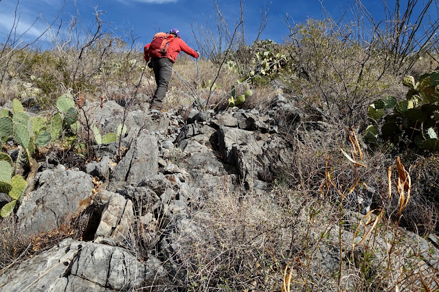
Peak 5,012' is also composed of limestone. The next two shots were taken at 4,700 feet and are good indicators of the amount of brush and quality of the footing.

This image looks back on the Visitor Center. The slope is covered in Santa Rita Pricklypear.

The last 100 feet kicks up. Top out on the summit at 0.6 mile. The peak register dates to 2008. From a rise of 512 feet, see the Mount Hopkins Road winding its way to the observatory at elevation 8,585 feet. The summit observatory is operated jointly by the Smithsonian Astrophysical Observatory and the University of Arizona for solar system, galactic and extragalactic astronomy.

Look north past Point 4,910' to Devils Cash Box, the instigator of this Three Devils day. On the return, it's just steep, rubbly, and brushy enough that you had best attend to each step. Don't let that puzzle you. It's inherent in the nature of this game.