Essence: There are three principal approaches to the Tower Mountain summit: from Velocity Basin (easiest), via Hematite Lake and Macomber Peak, and up through Boulder Gulch. Pay your dues up front on the ultra steep pitch through the Boulder Gulch gorge. Then pass through a rapturous high alpine basin brimming with wildflowers in mid-summer. After 4.0 miles, leave the Boulder Gulch Trail and ascend the exhilarating northwest ridge of Tower Mountain on Class 2 terrain. Views from the ridge are expansive and become full-circle glorious on the peak with its prominence of 1,622 feet. Tower is located north of Silverton on a wedge of terrain spiked with high and challenging peaks between Cement Creek and the Animas River. The Silverton Singletrack Society significantly improved the old treadway spanning from Boulder Gulch over the northwest ridge of Tower to Velocity Basin. Based on new, more accurate measurement technology, LiDAR, the elevation of Tower Mountain was lowered to 13,545 feet.
Travel: In Silverton, drive up Greene Street to the north end of town. Make a soft
right onto San Juan County Road 2. Drive 1.5 miles out the paved road and
park in a large dirt lot on the right near placards for the Mayflower
Mill Tailings Ponds.
Distance and Elevation Gain: 9.8 miles; 4,150 feet
Total Time: 6:00 to 8:00
Difficulty: Trail, off-trail; navigation easy; Class 2 with very mild exposure on northwest ridge of Tower
Maps: Silverton; Howardsville, Colorado 7.5' USGS Quads
Date Hiked: August 19, 2023
Quote: Nature is painting for us, day after day, pictures of infinite beauty. John Ruskin
Approached from Boulder Gulch, the summit of Tower Mountain remains hidden until the last possible moment. Alternatively, its bulky magnificence is in clear view from the Macomber Peak approach.

Route: From parking, walk north on the west side of the tailings and
intersect a dirt road. Turn right and cross the Boulder Gulch drainageway.
Hike north on the Boulder Gulch Trail until it intersects the northwest ridge of Tower Mountain. Ascend southeast to the summit. While this description is an out-and-back, with a shuttle, you could do the significantly shorter thru-hike on the Boulder Gulch Trail into Velocity Basin.

Boulder Gulch
From parking, elevation 9,487 feet, cross County Road 2 and walk up the two-track to the west of the tailings. The road is gated and closed to vehicle traffic.

Leave the road when it turns to the right at 0.25 mile and take a few paces straight ahead. Turn right on a secondary two-track. Watch for a cairn on your left marking a faint social trail leading up to a more established dirt road, shown, and turn right. You may walk to Boulder
Gulch from town on this road but it will cost you an extra mile.

Approach the creek on a cement apron. (Thomas Holt Ward, photo)

Cross to the east side of Boulder Gulch at 0.55 mile on a sturdy metal bridge.

The Boulder Gulch Trail is open to hikers, equestrians, and mountain bikers--no motos. The hike is mighty steep right out of the box. The stone stairstep warmup is followed by a couple of switchbacks. Then the trail parallels the gorge and replicates its gradient for the next mile. Returning, the descent is a slick slip and slide.

At 10,000 feet the trail crosses a blockfield on the lower southwest slope of Macomber Peak. The generous platform was engineered by repositioning great quantities of rock to fashion a boulder hallway--a tribute to the Singletrack Society's masterful effort to defy gravity. (THW, photo)
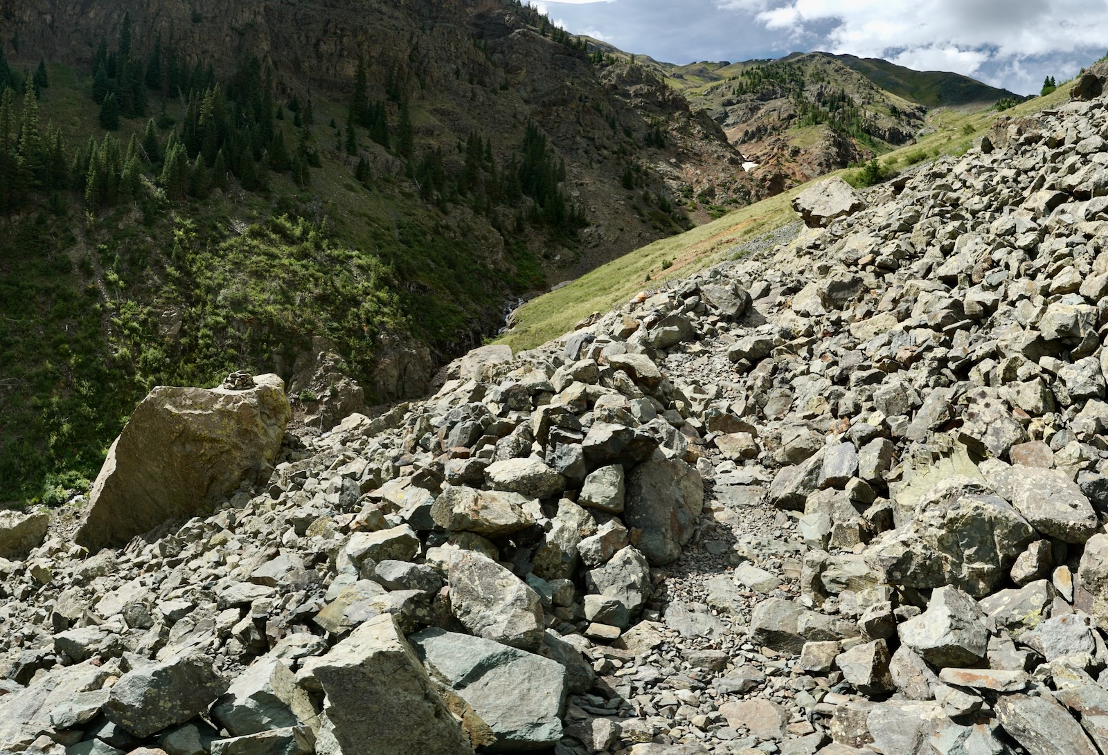
This photo taken on the return illustrates the power of erosion to fracture and break down a mountain. Perhaps the gulch was named in reference to this massive boulder pileup.

After a big winter in 2023, pockets of avalanche debris lingered on the floor of the gorge. Viewed from 10,300 feet, water plunging from thirteeners on the Storm Peak divide flowed under snow bridges.

At 1.0 mile the trail enters an aspen forest. Still climbing steeply, dappled light transitions to deep shade as the soft dirt path treads through spruce and fir. At 10,800 feet, timber recedes and the visual field expands. Sheets of water cascade over black rock in the widening corridor. (THW, photo)

According to the Singletrack Society the Boulder Gulch Trail is a screaming mountain
bike descent that drops 3,700 feet over four miles. Cyclists are required to
carry their bikes for the 1,700-foot ascent out of Velocity Basin. This brutal hike-a-bike may explain why we saw and heard more pikas than mountain bikers.

Mid-August, flowers were waning in lower elevations but peaking in the alpine. In the morning, water was pouring from the thick mat of brilliant moss, shown. A few hours later the rivulet was dry.

In 2022, we climbed Velocity Peak from Boulder Gulch. The route leaves the gulch midway to the divide and mounts the southeast ridge, shown. Though we'd climbed Tower Mountain many times from other approaches, we were so enamored with the terrain we promised ourselves we're return to pass through the resplendent tundra-clad basin en route to the mountain.

Looking west, an intriguing white vein streaks through "Storm Gulch." (THW, photo)

Cross over to the west side of the basin at 2.1 miles, 11,440 feet. You could not dream up a landscape this wondrous.

Going and coming we always pause at the crossing to rest amongst the flowers. Below, a pollinator visits a queen's crown. (THW, photo)

The trail makes an elongated switchback to the west. The roaring stream drains cirque-borne lakes tucked in the shared basin beneath Storm and Velocity peaks. Storm Gulch is a substantial contributor to the primary waterway.
(THW, photo)

Alluring and perilous Storm Peak appears irresistible in its proximity but it is best approached from the west (Cement Creek). The standard route traverses a fierce and fractured ridge with a string of eight or more near vertical 30 to 80 foot knobs separated
by small saddles and short knife stretches.

At 2.4 miles, 11,700 feet, the pathway cranks northeast and wraps back into the gulch proper while holding the contour momentarily. Bearing north on the west side of the basin, there is a clear view of the rim. Studying the map, this location is a triple divide separating Boulder Gulch from Velocity Basin (north) and the South Fork of the Animas River (east).

The upper basin broadens still more. The landscape is both sparse and intense. The sweep of tundra is interrupted by two bands of volcanic rock with bulbous outcrops. While the grade is moderated overall, there are a couple of short and very steep pitches through breaks in the cliffs. The image below shows the trail approaching the jump up through the first rocky band.

This image looks down on a couple of tarns strung along the headwater stream of Boulder Gulch and a majestic swath of bluebells bordered by the west wall of Tower Mountain. One glance takes in a lush garden and a primordial, primitive rockscape.

We plowed through lavish fields of flowers. It's a little counterintuitive but flowers in the alpine come on early and linger late. Between the extravagant floral display and the cerulean sky the surrounds were dazzling.

Below, a bee blends in perfectly with its food source. (THW, photo)

The Boulder Gulch Trail is favored by Silverton's community of ultra-runners. Below, a fleet-footed runner dashes up and through the first cliff band. Pay close attention to stay on the trail through rocky segments. Tall cairns that served as guides have been deliberately toppled.

At 12,200 feet the trail gives up a little ground while remaining west of the second band that spans the center of the basin. The path exploits a weakness in the cliffs created by a rivulet. Punch up the steep pitch west of the stream.


Cross the flower-framed rill at 3.6 miles, 12,620 feet.

At roughly 12,750 feet, the Grenadier Range makes it visually over the top of the Kendall group. 

The trail passes the headwater lake on its east. Below, Velocity is image-center and Storm Peak is to its right. This image illustrates why it is hard to achieve Velocity from the northeast ridge, though it has been done.

The trail makes a defining switchback and gains the northwest ridge of Tower at 4.0 miles, 12,980 feet, in the saddle just south of Point 13,060'. A steel stake is driven into a big pile of rocks to mark this important location.

Tower Mountain
Turn southeast for the ridgecrest traverse to Tower Mountain. The social trail is fragmentary but there when you need it. Hikers with sharp eyes can just make out the summit tower to the right of the symmetrical gray knob.

For those comfortable with walking near of the east edge the payback is significant. I felt suspended over voluminous space. In the far distance is Half Peak. Dome Mountain is to its right, sunlit and nearby. Clusters of tarns are embedded on velvet green benches in the headwater basin of the South Fork of the Animas River.

A good social trail flanks the first substantial roller on the west.

The footpath zigzags up through small talus and scree. The trail is boot-worn into the slope. The incline is just steep enough that some hikers might feel a sense of exposure.

After returning to the ridgecrest the trail cuts around the next prominent gray knob on the west.

The form of the peak becomes clear at 13,360 feet when you are practically on top of it. The ridge necks down to about four feet for a short distance with secure footing.

The divide widens remarkably onto a broad expanse with a thin layer of tundra clinging to chipped rock. Clumps of glowing rosy paintbrush flashed brilliance. It struck us as unusual that the approach from the north would provide an obstacle-free gentle finish. The south and east ridges are more demanding. While topping out on the summit at 4.9 miles after 4,100 feet of climbing, we could hear the train pulling into Silverton. My sense of elation was roughly equivalent to the insane vista overlooking far flung peaks intimately familiar to us. The image below ranges from the Twilights to the Mount Sneffles Wilderness. (THW, photo)

The peak register placed two weeks prior posted the latest LiDAR elevation for Tower Mountain, 13,545'. As for the tower, it wasn't hooked up to anything on my first visit in 2008, and it's become a little piece of percussive art. Looking northeast, Wetterhorn and Handies peaks are on either side of the summit.

The east ridge is a viable but challenging route back to the Hematite Lake Trail.

Our standard route over many years has been Hematite Lake to Macomber Peak, shown, and the south ridge traverse to Tower. (THW, photo)

Below. the sun highlights the approach ridge and the unmistakable Red Mountains.

Return to Boulder Gulch Trailhead
The mountain was so intoxicating we were reluctant to begin our journey homeward. We descended over the prominent gray knob for a quick diversion off-trail. (THW, photo)

This image looks out over Boulder Gulch (find the trail!) to the ridge leading to Velocity Peak, visually obscured by Storm Peak. Easier to decipher is Point 13,248' on the south ridge of Storm. For the curious, in 2006, I climbed Point 13,248' in a thwarted attempt to summit Storm Peak from Boulder Gulch. North of Point 13,254' we confronted an impassible 80-foot vertical block.

Back in the saddle south of Point 13,060', it was a simple jaunt to the 12,940-foot low point on the Boulder Gulch-Velocity Basin divide.

From the cliff-lined vantage point we could look into Velocity Basin 1,640 feet below. (THW, photo)

As seen on the map above, we made an irresistible shortcut on the Storm Gulch switchback.

The diversity and abundance of wildflowers was a bonus feature of this hike. Following is a list of 60 species in order of appearance: fireweed, cinquefoil, potentilla, baneberry, bottle gentian, pussytoes, orange sneezeweed, native honeysuckle, columbine, moss campion, Greys' angelica, bluebell, osha, Indian paintbrush, orange sneezeweed, elegant death camas, rayless senecio, caraway, brookcress, queen's crown, Geyer onion, clover, yarrow, pink aster, harebell, little sunflower, dusky penstemon, delphinium, geranium, candytuft, draba, solidago, ball head waterleaf, Coulter's erigeron, edible valerian, American bistort, alpine avens, Wyoming and hybrid paintbrush, kittentail, burnt orange agoseris, fernleaf lousewort, elephant head, fairy candelabra, snow buttercups, Fendler's sandwort, king's crown, salvia, yellow stonecrop, Parry's primrose, marsh marigold, globe flower, snowball saxifrage, showy ragwort, rosy paintbrush, purple fringe, sky pilot, deep rooted spring beauty, veronica, and Arctic gentian.
Yellow stonecrop is a mashup of rich maroons and brilliant yellows. The
sedum thrives on open rock and gravel in full sunlight from the
foothills to the alpine. (THW, photo)
