Friday, October 30, 2020

Peak 5,932', Points 5,821' and 5,575' from Old Sheffield Road

Essence: This hike and climb offers aesthetic, intellectual, and soulful fulfillment to every person wandering in Red Breaks who looked east and longed to climb Peak 5,932'. From the west it appears as an equilateral triangle the color of hot iron cooled to smoldering garnet. Summit three prominences, delve deeply into a two-chambered grotto, and circumnavigate the cluster located between Red Breaks and the Escalante River. Peak 5,932' throws up a lot of challenges and navigation is demanding. The route is revealed as you climb and probe. The wonder of walking on Navajo Sandstone lies beyond the reach of words but sand slogging may temper your incredulity. The hike is within the Grand Staircase-Escalante National Monument. 
Travel: Old Sheffield Road is off Utah 12 between Escalante and Boulder. At mile marker 70 (where a cattle guard crosses the highway), turn south on a dirt road and start measuring distance from there. At 5.7 miles in Big Spencer Flat, the main road goes right/south. Take the left fork trending east. The parking area is 6.6 miles from the highway. It is a good road when dry, suitable for 2WD with good clearance. Check road conditions by calling the Interagency Visitor Center in Escalante. 
Distance and Elevation Gain: 13.0 miles or more depending on probes and exploration; 2,000 feet of climbing
Total Time: 7:00 to 9:00
Difficulty: Sandy track and slickrock, primarily off-trail; navigation challenging (experience required); Class 2+; mild exposure
Map: Red Breaks, Utah 7.5' USGS Quad
Date Hiked: October 30, 2020
Quote: The future belongs to those who believe in the beauty of their dreams. Eleanor Roosevelt. 

Point 5,821' and Peak 5,932' are a study in opposites. The rounded, welcoming point is an easy walkup to a summit that goes on forever. The well-armored, sheer-faced peak permits one safe path to its airy apex. 

Route: Hike east, south of Spencer Canyon, and then southeast staying on or near the rock line flowing from Peak 5,981'. Cross a dry tributary of the Escalante River heading northeast and then climb southeast into the grotto. Climb Point 5,821', Peak 5,932', and then circumnavigate the cluster by going over Point 5,575'. Close the loop and hike out as you came. Our track was a wild mess due to several fruitless probes. Below is a cleaned up version to mitigate confusion. 

Walk east out of the large parking area, elevation 5,760 feet, on a continuation of the Old Sheffield Road. There is likely to be a lot of footprints in the sand but they soon dwindle and solitude will be your companion for the remainder of the day. A friend calls this initial sand slog the Big Hurt and you may agree while trudging uphill at the end of the hike. Piñon and both Utah and Rock Mountain juniper have managed to take hold on the sand plain. The ubiquitous sand sagebrush, shown, prefers deep sandy soil habitats found on the Colorado Plateau, including Southern Utah.  

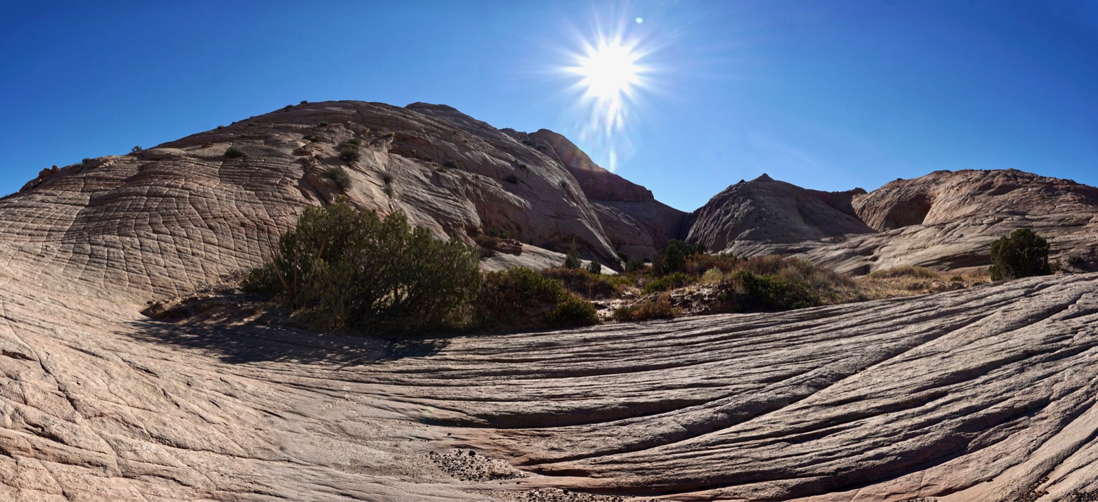
In morning light our two primary peaks will appear as silhouettes; they are visible on and off as you approach. Looking at this image shot in the afternoon, the route tracks south of incised Spencer Canyon framed by deeply fractured, massive sandstone formations, image-left. The route curves southeast and tracks under the flat-topped mesa, Peak 5,981', and then enters the grotto between the two prominences, image-right.

For strong adventurers, you could reasonably visit the Spencer Canyon Grid either going or coming. It is a rare opportunity to study a right-angled world with forks bisecting the main canyon on its way to the Escalante River.

Cross into the Wilderness Study Area at 0.8 mile. In 1.3 miles, transition from the track onto a polygonal sandstone slab at the head of "Ponderosa Pine Valley." The numerous grand, old growth trees are thriving along a survival thread where they are moistened by occasional waters in the wash and slickrock runoff. (Thomas Holt Ward, photo)

Hold your eastward bearing while crossing a series of drainages, typically dry. "Super Tanker Wash" has been a reliable source for clear water in years past but in 2020 it was bone dry as the Southwest suffers under a pitiless drought. Cross between the tanks on a stone rib. A tenth of a mile further, cross a south fork of Spencer. It emanates from the escarpment of Red Breaks near Point 6,015'. Walk downstream to see the watercourse plunge into the Spencer Canyon abyss. (THW, photo)

Moqui marbles, spherical iron oxide concretions, have rolled into sandstone cracks and spill out onto the surrounding platform. Black jewels cast long shadows in morning light. 

At 2.6 miles, turn 90 degrees to the south to skirt a small dome, image-center. Over the next 1.5 miles bear essentially southeast passing below a series of prominences, including the south ridge of Peak 5,981'. This is free-range rambling and you will inevitably cross fields of sand. But the closer you are to the formations, the better. Search out sandstone runners. 

 Make the most of a two-foot-wide sidewalk that curves around and heads a drainage.

Sandy patches hold clumps of ready-to-harvest Indian ricegrass in the fall and wildflowers in springtime. (THW, photo)

Sandstone flares from domes onto the benchland in a swirling and oozing blend of cream and terra cotta, colors predominate throughout the region. (THW, photo)

Crawl under a barbed wire fence at 3.7 miles. (THW, photo)

Three tenths of a mile past the fence you will round the south ridge of Peak 5,981' and see the two contrasting peaks. Descend into a south tributary of the Escalante River, at 4.1 miles. It trenches up further downstream. Walk east around the base of Point 5,821', shown.

Grotto
We'd spotted this hollow four years prior and resolved to return to see if we could ferret a way in. We anticipated a small enclosure but it turned out to be a large edifice. At 4.5 miles, head south up a relaxed pitch into the grotto. Note, the circumnavigation loop begins at the start of this ascent. With all of our probes it was a 4.4 mile loop for a total of 13.4 miles. Your mileage will vary. (THW, photo)

The flat-floored grotto is bifurcated by a ridge trending north from the headwall creating a lower and upper chamber.  The subtle hue of piñon and juniper is offset by the bright green leaves of manzanita and golden grasses. The walls of the lower chamber are smooth blank canvases with shallow alcoves. There was no sign of human presence as we walked into the confined and intimate enclosure. (THW, photo)

The flat western face of Peak 5,932' loomed 350 feet overhead as we walked into the squeeze at the back of the chamber. Soon it was a packs-off slot with rippled walls. We were pinched out near the headwall. (THW, photo)

A massive alcove hollows out the entrance to the equally beautiful higher chamber. (THW, photo)

The crack was every bit as compelling as the first. In just a few minutes we were looking down on this slot from Point 5,821'. 

Point 5,821'
Climbing Point 5,821' is easily done on the north slope. This image depicts the grotto and Peak 5,932'
from the start of the climb. (THW, photo)

Wander over the face of the slope looking for the shallowest pitch. There are plenty of features that make this climb quite safe and fun. 

The surface of the summit ridge is wondrous with outcrops and tanks evolving into weathering pits.  

The rounded sandstone crest is complicated and possesses a couple of highpoint candidates. The first is the tallest but at the time we weren't sure so we climbed the knob to the south just in case, shown. 

Peak 5,932'
We had no idea whether we could successfully climb the triangular peak and we figured it out on the fly. What follows is a description of our route. I got up there without scaring myself, a key consideration. First, we contemplated crossing the upper chamber headwall, shown. The bridge looked too exposed and we discarded the idea. That proved to be a good decision because the knife ridge ends at a dangerously steep slickrock slide. 

We descended southeast on a shallow slope a good distance and crossed a ravine, shown, emanating from the south side of the grotto headwall. It was a pleasure walking on sandstone biscuits.

The south ridge was armored so we started circling. We worked our way up the southeast face using a series of narrow benches. As is often the case with Navajo Sandstone what looks at a distance like a formidable wall turns out to be a slope textured with safety ledges. 

We were fortunate to happen upon a river of black-plate concretions. 

We wandered hither and yon finding a path upward. There were some steep friction pitches but they were protected with ledges. We discovered a comfortably wide platform at the base of the summit block at 5,820 feet. Looking at the image below, it is located where the color changes from beige to brick. 

We walked north searching the block looking for access. From the platform we could look into the "Milagro Passage." We discovered this corridor on the Spencer Canyon Grid and Ladder Canyon hike. The 50-foot-wide hallway is constrained by towering and sheer carmine walls. (THW, photo)

We'd almost circled to the west face drop when we got lucky and found a plausible route to the crest. We mounted the block at a crack on the north face, image-center. It is a fairly steep friction pitch. The zenith is the tan-colored stone on the skyline. 

We were elated and grateful to arrive on the apex, all the more spectacular by its tiny dimension. This image looks west across the gulping gap of the grotto to Point 5,821'. (THW, photo)

Nearby to the east is the Escalante River canyon with the Henry Mountains in the way beyond. On the Red Breaks topographical map, Point 5,543' and its subsidiary look inconsequential and we'd given thought to climbing them, image-left. But from here, they did not look casual and we left them in solitude.  

Point 5,575'
Mounting this point on a low ridge was unintentional. It turned out to be our way back to the trailhead. First, we down climbed back onto the platform. From there we descended to the rock outcrop, shown, and then dropped another 100 feet. The idea was to descend the north face but it rolled off and we could never get a visual all the way to the bottom. We retreated back up to the platform and retraced our steps to elevation 5,700 feet. 

At that point we thought it'd be fun to circumnavigate the cluster looking for alternative routes up the peak. We explored the east side of the mountain rich with cracks, alcoves, weathering pits, and dry tanks. We got cliffed out so we thought we'd go through the crack between Peak 5,932' and Point 5,575'. It was pinched at the south end so after fruitlessly hunting around for a way down in, we wandered up Point 5,575' hoping for no further obstacles. Sure enough, it was a gentle pitch down from there. We headed west and closed the loop.

This final image was shot from Point 5,575' toward the east face of Peak 5,932'. From here, it appears that skilled climbers may be able to mount the north face. Given the sublime nature of this route, I wouldn't trade away even one footstep for the sake of a more efficient climb.
An important note from author Steve Allen about protecting endangered National Monuments in Southern Utah. 

Thursday, October 29, 2020

Boulder Benchmark, 6,642', and Peak 6,507' from the Burr Trail

Essence: Boulder Benchmark is located north of the Burr Trail, west of Deer Creek, and east of the town of Boulder, Utah. Revel in relaxed slickrock hiking while climbing Peak 6,507', the high point on a piñon-juniper topped mesa. Resting on swaths of Navajo Sandstone are rounded boulder volcanics. The wide-spread abundance of "boulder balls" is just one compelling feature in this geological wonderland. The hike is within the Grand Staircase-Escalante National Monument.
Travel: Measure distance from the junction of Utah 12 and the Burr Trail in the town of Boulder. Drive east on the paved Burr Trail, entering GSENM. Most of the hike is visible from the road. At 5.2 miles, pull into a large gravel parking lot and primitive camping area on the right. If you are driving along the Burr Trail from the east, watch for a magnificent ponderosa in the center of the pullout, 1.1 miles west of Deer Creek. 
Distance and Elevation Gain: 8 miles; 1,800 feet of climbing
Total Time: 5:00 to 6:30
Difficulty: Off-trail; navigation moderate; Class 2; no exposure
Maps: King Bench; Steep Creek Bench, Utah 7.5' USGS Quads
Date Hiked: October 29, 2020
Quote: Are these the end times? Yes. And they have been this way since the beginning. Welcome to planet Earth, a wonderful but not entirely stable place to live. Craig Childs

Catastrophic flows during the Ice Age dislodged black basalt boulders from the High Plateau of Boulder Mountain and stranded them throughout the region. They adorn the surface of the Navajo Sandstone composing Boulder Benchmark, image-center. Deer Creek, the red corridor on the right, begins from an incision on the steep southern slopes of the 70 square mile Boulder Mountain summit. (Thomas Holt Ward, photo)

Route: Cross the Burr Trail and head north up onto a large mesa, topping out on Peak 6,507'. Descend north to the saddle south of Boulder Benchmark being careful to skirt private property. This land is delineated on the map to the right of my track in a light color. Bear northeast, heading two ravines, and mount the south slope of the benchmark. Continue northwest to a better viewpoint on a low prominence if you wish. On the return, you may flank Peak 6,507' on the east. 

From the parking lot, elevation 5,820 feet, look north and locate two sandstone knobs. We climbed the craggy knob left of image-center for fun but you may skip it and head directly up the prominence on the south rim of the first mesa, image-right. Regardless, cross the Burr Trail and walk up a minor wash. It is sandy at first but very soon transitions to bedrock.

You will get a flavor for this mellow, pleasant hike immediately while weaving through boulder balls strewn about. Notice the mustard-colored liesegang banding embedded in the sandstone, here and throughout the area.

Standing on the initial knob at 6,300 feet, 0.8 mile, look back on the Burr Trail, the angular dome east of the parking lot, and Durffey Mesa west of Deer Creek. (THW, photo)

My knowledge of geology is rudimentary but even so, I was struck by the varied geological phenomena seen on this short trek. The fundamental rock is Navajo Sandstone. In characteristic shades of white, it is prominent throughout Southern Utah and the Colorado Plateau. It was once the largest sand desert in the history of the Earth. The formation is 2,200 feet thick in places. It forms rounded domes, sheer cliffs, and slickrock sheets. 

Scattered about on the surface are irregular-shaped concretions. These features form early in the burial history of the sediment. They are formed by the precipitation of mineral cement which makes them more resistant to weathering than the sedimentary host stratum. The iron-colored ripples and bubbles throw off sheens of light. 

Also lying on the surface is an abundance of chalcedony, a microcrystalline form of silica created during volcanic activity. Some of the stones are translucent (agate) and others opaque (chert). Presumably, they were brought down from Boulder Mountain along with the basalt boulders. We happened upon lithic scatters of worked chalcedony. Please leave the lithic feed stocks and archaeological treasures where you find them. 

Barge through an astonishing number of naturally distributed boulders that are strikingly out of place. They vary tremendously in size from spheres you'll dislodge with your step to boulders rivaling your height. Bluebell Knob (elevation 11,317 feet) is the crest of Boulder Mountain located on the Aquarius Plateau, the tallest of the High Plateaus of Utah. The rounded basalt and andesite boulders originated in 20 million-year-old lava flows that mantle Boulder Mountain. The freight of boulders was hurled down from the mountain by floods and debris flows at a time when the Ice Age glaciers were melting. As you climb to the knob at the south end of the first mesa, the boulder balls are on the verge of becoming an obstacle. 

Walk due north across the flat mesa top. The mature piñon-juniper woodland is complimented by ephedra, sagebrush, snakeweed, and buffaloberry. The ground is spongy, showing no sign of a social trail or even footprints. Nondescript Peak 6507', 1.9 miles, is at the far north end of the mesa. From here, you'll have a visual of Boulder Benchmark, the sandstone butte west of Deer Creek, shown below. Take stock of your intended route before launching so you do not infringe on private property which includes the saddle and land to the east. We dropped west of the ridgeline as we approached the saddle. 

From the highpoint, descend through a boulder field onto the slickrock. Singular concretions embellish the broad expanse of smooth white stone. 

We happened on the southwest property corner near the saddle. 

Walk through a sage flat as you pass west of the saddle at 6,140 feet, 2.5 miles. Boulder Benchmark is image-right.

Our final approach to the crest was optimal on a shallow inclined plane, avoiding steep slopes elsewhere.

Two ravines flow southwest on the southern slope of the mountain. Head them both on the east.

A solitary hoodoo stands on the north rim of the second and larger ravine.  

Sandstone is weathering out from under a balancing boulder. (THW, photo)

As we topped out on the butte, we had to hunt around for the Peak 6,642' benchmark. It is located near the southeast corner, 3.4 miles. The tiny piece, the size of a quarter, is on an inconspicuous boulder low to the ground. 

Consider walking to the north end of the butte and continuing on to the yellowish dome pictured below. It's just another 0.4 mile and is an excellent viewpoint. You'll have to turn around here because it is very near the Monument boundary. 

Pass over sandstone painted crimson by the iron-bearing mineral hematite. 

Pick your way through another community of boulder balls. (THW, photo)

Seen from the globular sandstone knob, nearby in the west are irrigated fields on the outskirts of the town of Boulder. (THW, photo)

East, is the main channel of Deer Creek, Peak 6,597', and the Henry Mountains. Visible in this image is Mount Ellen in the north block. 

It appears that Nature got a little carried away dispensing peppercorns on the western slopes of Boulder Benchmark. (THW, photo)

Return to the benchmark. Pictured below is the south slope, the private land east of our route, and the north and east slopes of Peak 6,507'. You may either return over the top of the mesa (the easier choice) or flank it on the east. 

We wanted to see more terrain so we diverged from our incoming route at elevation 6,340 feet and headed southeast, shown. 

We bypassed a wall by walking east for a short distance. We returned to the proper trajectory on a lower bench, shown. The terrace dwindles and footing is uneven on the rubbly, slanted slope. 

Keep heading southwest and you will cross a low ridge at 7.3 miles, 6,000 feet. From there you will see the familiar dome signifying the location of the parking lot.