Tuesday, March 31, 2020

Smelter Mountain, 7,725', Durango, Colorado

Essence: The summit of Smelter Mountain is the midpoint of an east-west running ridge stretching from the Animas River in southwest Durango to Wildcat Canyon. The rugged and rocky trail is steep and short. In one mile it climbs over 1,000 feet to the "East End Viewpoint," everyone's favorite Durango overlook. Check out historic Main Avenue, the Animas River, and the Durango & Silverton Narrow Gauge Railroad yard at your feet. Survey outward to the La Plata Mountains, the San Juans, and local landmarks. Smelter is enthusiastically embraced by runners during lunch hour and families on weekends. You'd like a jolt of joy? Go hike Smelter. The mountain is within Bodo State Wildlife Area managed by Colorado Parks and Wildlife. Wintertime restrictions are noted. This post is a little different than other Earthline contributions. It doubles as an Outdoor Classroom exercise for school children.
Travel: Turn west off US 550 at South Camino del Rio. This is the first signal south of Santa Rita Park. As soon as the road starts to straighten, turn right onto CR 210. In less than 0.1 mile, turn right on Smelter Place. Trailhead parking is on the left in a dirt lot before the baseball diamonds.
Distance and Elevation Gain Roundtrip: East End Viewpoint is 2.0 miles with 1,050 feet of climbing. Smelter Mountain summit: add 2 miles and 450 feet of vertical. Dog Park: add 2.4 miles and 100 feet of gain.
Total Time: 1:00 to 2:00 from the trailhead to East End Viewpoint and back.
Difficulty: Unmaintained trail; navigation easy; no exposure assuming you stay a safe distance from the cliff.
Bodo State Wildlife Area, Winter Access Restrictions: Smelter Mountain is within the 2,923 acre Bodo SWA. From December 1 to April 15, the trail is open to the East End Viewpoint only. Hike between 10 AM and 2 PM. Dogs are not allowed and hikers are asked to stay on the trail. The restrictions are to protect wildlife habitat such as mule deer, year round residents. Please leave your dog at home or walk to the Dog Park in winter months. Leash your dog during open season.
Maps: Durango West, Colorado 7.5' USGS Quad; or, Trails Illustrated, Durango, Cortez, No. 144
Reference: The Best Durango Hikes, Colorado Mountain Club, 2011. "Smelter Mountain," by John Bregar
Quote: You can observe a lot just by watching. Lawrence Peter Berra (Yogi Berra)

Multiple landforms constrain the Animas River Valley and City of Durango. Smelter Mountain creates a natural boundary on the southwest side of town. Mount the Sky Steps for the best visual of the mountain. The hiking trail goes up the ridgeline on the left.

Route: Ascend the southeast ridge to the East End Viewpoint, the black-line trail. To reach the summit walk west on a dirt road servicing communication towers, the blue-line. Extend your hike by walking south from the Dog Park to the trailhead, the red-line.
 

This post was written in the Spring of 2020 when the Coronavirus Pandemic ravaged the globe. Colorado governor Jared Polis issued stay-at-home orders. Schools were closed and all but essential businesses shuttered. Daily exercise was encouraged. Most Durangoans can get to the Smelter Mountain Trailhead by foot or bicycle.

Social-Distancing Guidelines During the Pandemic: The Smelter Mountain Trail is narrow. Keep at least six feet from other trail users. This is a family-centered field trip; hike with people in your household or go solo. When winter restrictions are lifted (April 16 through November 30), spread yourselves out by hiking early in the morning or late in the afternoon.

Outdoor Classroom: Students will learn about the history of Smelter Mountain, geology, flora, and geography. This hike is suitable for active children ages five and up. Take the ten-point quiz at the end of this post!

How Did Smelter Mountain Get Its Name?
The Durango Smelter began operating on a grand scale in1882. High heat stoked in kilns was used to extract silver, gold, copper, and lead from rock mined in the San Juan Mountains. The operation at what is now the Dog Park and baseball fields west of the Animas River was so significant the town was nicknamed Smelter City. The mill ran until 1930. With the advent of World War II, uranium was produced on the same site for two decades. Tailings are buried on the south side of the mountain at the 120-acre Bodo Canyon Disposal Site managed by the U.S. Department of Energy.

Trailhead Geology
There is a lot to learn right from the parking lot. Durango geologist John Bregar said Smelter, Raider Ridge and Crader Ridge are three in a series of hogbacks tilted up and rammed against the San Juan Mountains. Hogbacks are long, narrow ridges with steep slopes of nearly equal inclination on both flanks. Smelter is a continuation of Raider Ridge. The sandstone layers that hold up Raider Ridge come across the river and hold up Smelter.

There are four primary rock formations on Smelter Mountain. Once you know what you are looking for you will find the same rock layers on Perins Peak and Twin Buttes. Mancos Shale is the thickest and oldest formation. It underlies the Mesa Verde Group which is composed of three layers. Point Lookout Sandstone is the lowest (and therefore oldest) member of the Mesa Verde Group, deposited in the Cretaceous era as the Western Interior Seaway receded. It is named for the dramatic protruding cliff at the entrance to Mesa Verde National Park.

The middle layer is the Menefee Formation. It contains coal veins so pure the D&SNG shovels it into their fireboxes. Capping the ridge is Cliff House Sandstone, the youngest member of the Mesa Verde Group. The formation was named for the Ancestral Puebloan habitation sites built in alcoves typically found in this layer. It was deposited when the sea was rising to inundate the Colorado Plateau once again. Just think, the rise and fall of the sea is recorded in the rocks.

Smelter Mountain Trailhead, Elevation 6,540 Feet
Let's get hiking! From the trailhead notice the three bands of Point Lookout Sandstone on the front face of the mountain. This is the southeast ridge and we'll be walking up it all the way to the top.

The single track descends about 50 feet to an ephemeral creek that collects water from the south flank of the hogback. Jump across the pretty little stream flowing over a sandstone bed.
 

The trail climbs to a powerline support tower and there it splits. Turn left to climb the mountain. Straight ahead is a popular backdoor entrance to the Dog Park. We'll talk about that trail later. Winter access restrictions are posted as you pass into Bodo State Wildlife Area. If you brought your dog during the restricted months, go play in the Dog Park.
 

The trail braids multiple times on the lower mountain. I like to go right at the Bodo SWA boundary sign. The trail contacts beige-gray Point Lookout Sandstone. The fun begins in the big slabs and blocks. (Thomas Holt Ward, photo)

Beside the path is an example of Liesegang rings made from minerals in sedimentary rock. The mustard-colored banding goes all around the surface of the rectangular rock. Now that you are alert to this distinctive banding you will see it throughout the Point Lookout formation.

The trail splits again under the third cliff band. The left hand option is a little more tame with natural stone steps.
(THW, photo)
 

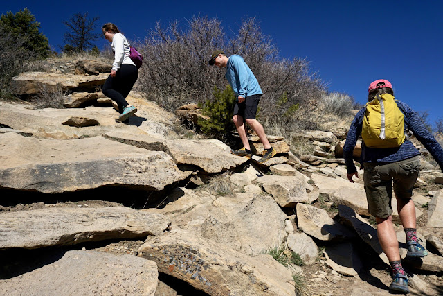
Turn right if you like to play around on big rocks. Practice your scrambling techniques! Put yourself into four wheel drive by using your hands for extra propulsion. (THW, photo)
 

The two trails come back together on a sandstone table. The banana yucca was a food source for Native Americans. In late spring a long cluster of large, white flowers with a purple tinge will shoot up from the broad, spine-tipped leaves. Return in the fall when the fruit is ripe and sweet. (THW, photo)

The trail barges up an open slope. In springtime this hillside will come alive with wildflowers. As you climb the hill you will begin to see smooth, rolled cobbles and boulders that seem out of place. These floaters rolled down the hill from an alluvium deposit near the top of the slope.
 

John Bregar explained that long ago the outwash plain for the Animas River used to be at this level, 6,900 feet. During the Quaternary glacial period, boulders and cobbles were deposited when ice dams shattered at the terminus of the glacier. All that remains on Smelter Mountain is this little pocket. The boulders have various markings and colors. The rocks are named for places we all know and love: Eolus Granite, Uncompahgre Quartzite, and Snowdon Quartzite.
 

The gravel quarry on Highway 3 is mining an alluvial deposit from the same geologic era.

Enter a piƱon and juniper woodland with a few ponderosa pines scattered about. There are two types of juniper. The Rocky Mountain juniper typically has a blue-green cast, image-right. It is sometimes called a "weeping" juniper because its leaves are feathery and droopy. The Rocky Mountain juniper grows straight up from a central trunk and is peaked or rounded at the top. It can grow to be 30 feet tall.

Utah juniper are a darker yellow-green and the foliage is stiffer. It branches out from the base into a broad spreading tree that can be as wide as it is tall, up to 20 feet. (THW, photo)

Smelter is a wintertime fitness favorite because it is free of snow earlier than other grades in town. Give it a few days to dry out or you will be mired in thick, gushy, slippery, mud. During mud season I am especially fond of these stepping stone slabs.
 

You will know when you contact the Menefee Formation because the trail platform turns black. The D&SNG obtains their coal from a Menefee seam mined by the King Coal II Mine in Hay Gulch.
 

Arrive at an exhilarating and open air lookout at 0.8 mile, 7,280 feet. What an exciting view of town and points north. This little opening is so satisfying some hikers call it good enough and turn around here. The next lift looks a little daunting but by now you've got most of the elevation gain put away. Dig deep and heft up the last 300 feet to the top. (THW, photo)
 

Transition to the Cliff House Sandstone formation. It is the topmost resistant bed in the Mesa Verde Group. It is so strong and powerful it holds up the Smelter ridge crest. It is easy to distinguish from other formations by its yellow hue. In the image below, Cliff House boulders are slumping down on the Menefee. This is a good example of a geological contact line.

The rough trail climbs steeply west along the north rim of the ridge with frequent views through Gambel oak.
(THW, photo)
 

Be sure to swing around and look south to Bodo and Carbon Mountain. (THW, photo)
 

A row of yellow Cliff House blocks jutting out over thin air signals arrival at the East End Viewpoint. Golden eagles and red-trailed hawks circle overhead and the vista is downright astonishing. In your euphoria, don't just plop down on any old rock. Choose your boulder carefully--erosion is a powerful and capricious master. Young children need attentive supervision.
 

This is every local's favorite view of town. Name what you see: the Animas River pulsing blue power, the crescent-shaped Train Depot, historic downtown, US 550 and US 160 joining at Camino del Rio, Main Avenue heading north arrow straight, and Fort Lewis College up on the Rim. On the second level are Animas City Mountain, Missionary Ridge, Raider Ridge, and Crader Ridge. In the north and east, so high they are touching the sky, are the San Juan Mountains: Engineer Mountain (off-image), the Twilights (West Needle Mountains), and Mountain View Crest. (THW, photo)

Northwest are the La Plata Mountains. In the midway zone, Point Lookout Sandstone cliffs ring Twin Butte East and compose the east scarp of Perins Peak. The Hogback is a classic example of Mancos Shale.
 

Smelter Mountain, 7,725'
The summit ridge is closed to hikers west of the East End Viewpoint from December 1 through April 15. The crest of the hogback is one mile west. It is the fifth and final roller and each one is planted with communication towers of various sorts and small buildings.
 

Walk west on the dirt service road. Spurs peel off to the towers. Check them out or flank the ridgecrest on the south with a view of Lake Nighthorse. (THW, photo)

The summit is topped with appliances but it does render an unusual perspective on the Animas River Valley. Runners can create a six-mile loop by going south on CR 212 and east on paved CR 210 back to the trailhead.

Durango Dog Park Access: 
I like to tie up my townie at the north end of the Dog Park and walk 1.2 miles south to the Smelter Mountain Trail. Not only is it a great warmup, the Dog Park is always a cheerful place. Many tracks cross the north platform. You can walk near the river or tuck beneath the east face of the mountain.
 

The bench narrows to the width of an abandoned road high above the river overlooking Whitewater Park.

People and dogs pass this way often but there is a risk. Big blocks break with alarming frequency from the Point Lookout Sandstone cliffs and litter the narrow passage. I have been walking here for twenty years and there's a new fallen boulder every time I pass by. This is not a place to hang out.
 

Smelter Mountain Outdoor Classroom Quiz
1. How did Smelter Mountain get its name?
2. What do geologists call a long, narrow ridge with equally steep slopes on both flanks? Extra credit: Smelter Mountain is a continuation of what ridge on the east side of the Animas River?
3. What are the three rock formations in the Mesa Verde Group? 
4. Order them oldest to youngest. 
5. Name the color of each formation.
6. How did the colorful rounded cobbles and boulders in the alluvial pocket get way up on the hill? 
7. Two kinds of junipers live on Smelter Mountain. What are they and how do you tell them apart?
8. What plant bears tasty fruit in the fall? 
9. What is the mountain range northwest of Durango?
10. What is the mountain range north and east of Durango?

Saturday, March 7, 2020

Box Camp Trail, Pusch Ridge Wilderness

Essence: The Box Camp Trail (BCT) is an historic link between the Mount Lemmon Highway and the East Fork of Sabino Canyon. It was the main pack trail into the high country of the Santa Catalina Mountains until 1920 when the Oracle Control Road was completed from Oracle to Summerhaven. Over 7.1 miles the trail descends a whopping 4,450 feet while meandering through weathered Catalina Granite boulders and passing through multiple life zones. Commanding views will always be out in front if you hike downhill. The BCT ends at the East Fork of Sabino Canyon but the hike isn't over! Exit at the Sabino Canyon Recreation Area or Hirabayashi Trailhead. The hike is within the Pusch Ridge Wilderness--no dogs, please.
Travel: Shuttle required. Drop a vehicle at Sabino Canyon Recreation Area or Gordon Hirabayashi Trailhead and drive to the BCT Trailhead. The shuttle from Sabino is longer but the hike is less demanding.
Sabino Canyon Recreation Area: Located at the northeast corner of Sunrise Drive and Sabino Canyon Road in Tucson. The parking lot fills on weekends so arrive early. Overflow parking is half a mile north of the main entrance. Show your Coronado Recreation Pass, National Parks Pass, or pay the day-use fee. Tram and fee information.
Gordon Hirabayashi Trailhead and Campground: In Tucson, drive east on Tanque Verde Road and turn left on the Catalina (Mount Lemmon) Highway. Drive past Molino Basin and turn left at mile marker 7.3 at the sign for Gordon Hirabayashi Recreation Area, FSR 807. Drive through the shaded campground on a dirt road (tables, fire grates, food boxes, pit toilets, trash, no water) and park at the trailhead in 0.2 mile.
BCT Trailhead: On the Catalina Highway, pass by the Palisade Visitor Center and begin a downhill stretch. The signed trailhead is on the left just past Spencer Canyon Campground, mile marker 21.4. The lot holds a dozen cars. No facilities, no fees, no water, no dogs.
Distance and Elevation Gain: BCT Trailhead to the East Fork Trail is 7.1 miles with 150 feet of climbing and 4,450 feet of descent. Sabino Canyon Trail to Tram Stop #9: 2.7 miles, 100 feet of vertical. Add 3.8 miles if you walk down the park road. Hirabayashi Trailhead: 5.7 miles, 1,600 feet of climbing
Total Time: 5:00 to 8:00 depending on exit route.
Difficulty: Trail; navigation moderate; no exposure; hike on a cool day (winter months); all streams are ephemeral and Apache Spring is not reliable so carry all the water you will need.
Maps: Mount Bigelow; Mt. Lemmon; Sabino Canyon; Agua Caliente Hill, Arizona 7.5' USGS Quads, or Pusch Ridge Wilderness, Coronado National Forest, USDA Forest Service, 1:24,000
Date Hiked: March 7, 2020
References: The Santa Catalina Mountains, by Pete Cowgill and Eber Glendening, 1997.
"A Guide to the Geology of the Santa Catalina Mountains, Arizona: The geology and life zones of a Madrean Sky Island." Arizona Geological Survey, Down-to-Earth, #22, by John V. Bezy, 2016.
Quote: Certain trails are so elegant that they seem to lie sleeping just beneath the surface of the earth. Rather than being created by us, it is as if these trails unveil themselves through us. Robert Moor, On Trails 

From the overlook above the confluence of the three forks of Sabino Canyon, Box Camp Canyon is image-left and Palisade Canyon is on the right. After passing Apache Spring, the trail descends along the east rim of Box Camp Canyon before working its way over to the ridge just west of Palisade.

Route: For legibility, the hike is split between two maps. The first map shows the route bearing southwest from the BCT Trailhead to Apache Spring. The blue-line represents an optional side trip to Spencer Peak and the red-line is the side trip to Box Camp and Box Spring. Note: There is universal agreement that Apache Spring was incorrectly placed on the Mt. Lemmon topo. I have corrected the error. Also, the trail has been rerouted significantly since the topo was published in 1981. The black-line route is accurate for today's trail. The trail has a reputation for being hard to follow so we first hiked uphill from Sabino Canyon to Apache Spring. Next, we hiked downhill from the BCT Trailhead to the Hirabayashi Trailhead. The trail is clear in all but two places which will be discussed.

This map shows the lower part of the BCT and the two exit options. Sabino Canyon is the red-line and Hirabayashi is the purple-line route. Before realignment the BCT followed the east rim of Box Camp Canyon to the floor of the East Fork. Today, the junction of the three trails is further east of Box Camp Canyon. Take note if you are hiking uphill.

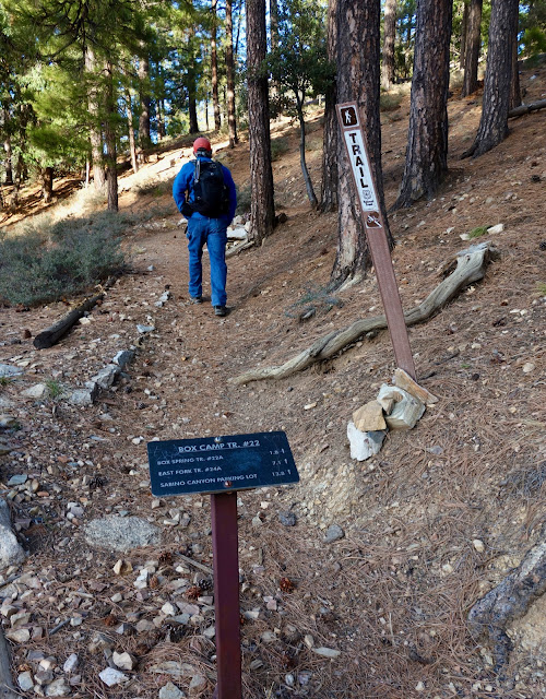
Box Camp Trail #22 to Box Spring Trail, 1.8 miles
From the trailhead, elevation 8,020 feet, the trail does a mini switchback before launching west to contour below Spencer Peak. The wide earthen path is coated with needles. Thriving in the Montane Fir and Pine Forest life zone are Arizona pine, southwestern white pine, Douglas fir, white fir, and gambel oak. The trees are big, the air is cool. (2021 Note: In June, 2020, a lightning strike ignited the Bighorn Fire on Pusch Ridge. By July, it had incinerated 119,987 acres. The fire had a significant impact on the forest surrounding the Box Camp Trail.)

Spencer Peak, 8,206', Side Trip
For those who can't pass beneath a nearby mountaintop, the optional side trip adds a mere 0.4 mile roundtrip and 200 feet of climbing. Watch for a singletrack branching right 400 feet from the trailhead. Walk under electric lines and weave around graythorn and deadfall to the crest. It's a nice little spot with openings in the forest to Radio Ridge and Mount Wrightson. 

Back on the trail, wind rustles through the pines and you can feel the mountain breathing. The Santa Catalina Mountains Sky Island is the greatest single expanse of high country within the Sonoran Desert with an unusual dome-like profile. The mix of rocks span 1.65 billion years (Bezy). Beside the trail are weathered Catalina Granite boulders. Vast views initiate and continue throughout the hike.

Cross into the Pusch Ridge Wilderness at 0.3 mile. Now in the Pine-Oak Woodland, a host of young ponderosa take shelter beneath old growth. To the northwest is Wilderness of Rocks, Marshall Peak (the green lump), Lemmon Rock Lookout, and the westward ridge holding the Mt. Lemmon Trail.
 

We saw two sets of cougar tracks at different elevations. (THW, photo)
 

Descend through a peaceful park with huge spaces between and beyond the trees. (THW, photo)

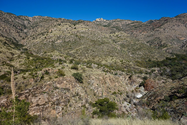
The footpath rolls off the ridge to the north and crosses the "Northwest Fork" of Palisade Canyon. The trail more or less follows this gorgeous stone watercourse all the way to Apache Spring. The only perennial streams on the Catalina front are Sabino and Lemmon Canyons. The channel drops, rocks step down, and water spills in small cascades.    

Pass a venerable, double-trunk alligator juniper while descending into drier habitat with Arizona oak, Mexican piƱon, Schott's yucca, and agave. Crews had been out recently cutting graythorn away from the trail and creating stylized water bars. Pass by veins of quartz and banded gneiss.

At 1.8 miles, 7,520 feet, Box Spring Trail #22A branches right at a cairn. Thinking there would be a sign we blew right by the turnoff and had to climb back. (In 2021 the cairn was gone.)

Box Camp and Box Spring Side Trip
Box Camp is 0.1 mile roundtrip and Box Spring is 0.6 mile out-and-back with a net loss of 300 feet.

Cowgill and Glendening write that Box Camp was named by early trail users who nailed boxes to trees for storage of food and other goods on trips into the high country. It is located on a large, pleasant flat with big views through the trees. (THW, photo)
 

We set off to find the spring that presumably supplied water for those in camp. The trail has fallen into disuse and is a tangled mess with deadfall and snarled brush, shown. Cross the Northwest Fork, ascend to the low ridge east of Point 7,523', and then plummet down the east wall of Sabino Canyon. Even in a wet year the small seep at 7,260 feet, yielded maybe enough water for a desperate party of one.

Box Spring Trail to Apache Spring, 2.3 miles
Box Camp is the turn around for casual hikers. The trail plunges and pines are replaced by madrone, oak, yucca, and manzanita. The well-cairned path is clear but needs clipping; wear long pants. When granite disintegrates, sharp-edged feldspar and quartz crystals contribute to the granular gravel (Bezy). The trail surface is slippery when steep.

At 7,200 feet, take a few steps off the trail to a lookout with Tucson and an immense span of Southern Arizona spread out below. This promontory marks the beginning of the open ridge section of the hike that extends nearly to Apache Spring. Thimble Peak, Saddleback Ridge, and Blackett's Ridge will be prominent in the view corridor all the way down the trail.
 

The impressive ridge to the southwest begins in Sabino Canyon, climbs to McFall Crags, goes up and over Rattlesnake Peak, and concludes with Cathedral Rock. (THW, photo)
 

The trail lies on the divide between the headwaters of Box Camp Canyon and the tower-filled tributaries of Palisade Canyon. Southeast is the triumvirate of the Rincon Mountain Sky Island: Mica Mountain, Rincon Peak, and Tanque Verde Peak.
 

The elongated and airy ridge is the scenic highlight of the BCT. (THW, photo) 

At 6,680 feet, the trail has been re-routed off the ridge to the west. It leaves the ridge at a distinctive, stacked hoodoo that sits out in the open. Immediately after passing a large outcrop, the trail does an eastward lateral and returns to the ridge. In 2020, the trail was overgrown so scout around for it. This image looks up at the hoodoo, image-center, and the gargoyle outcrop.
 

At 6,100 feet, Arizona oaks take hold, typical of the Evergreen Woodland life zone. Manzanita was blooming in winter (watch out for the bees!) and beargrass was prevalent.

We knew that the location of Apache Spring on the Mt. Lemmon topo was in error but we left the trail anyway to explore at 5,940 feet. This is the location of a significant trail reroute and there was no sign of the old track. We hunted around on the Northwest Fork and ruled out the existence of a spring. The granite-floored streambed is beautiful and there are a few small waterfalls and pools. (THW, photo)

Apache Spring is at the base of the small ridge capped with standing rocks, image-center.

Arrive at Apache Spring at 4.1 miles, 5,550 feet. The spring is but a seep in the stone-walled corridor and typically runs after summer rains and snow melt. On our two winter visits it was impossible to distinguish the spring from the waters of the Northwest Fork. (THW, photo)

Apache Spring to East Fork Trail, 3 miles
The BCT abandons the Northwest Fork which plunges to its confluence with Palisade. The path passes north of the standing rock ridge and then enters the Box Camp Canyon drainage. The trail works the east slope for almost 1,200 feet of descent. The hiker is completely engulfed in free-standing rock stacks, balanced rocks, and effigies. This is hoodoo country at its best. Below is an example of case hardened rock varnish on granite.
 

Stone pillars are within the Box Camp Canyon headwater bowl and all along its rim. 

On the floor of the bowl is vegetation typical of Semi-Desert Grassland: shindagger, sotol, pricklypear, resurrection plant, and rabbitbrush. Blooming in March were deervetch, Santa Catalina prairie clover, desert anemone, wild hyacinth, and verbena.

The trail makes a couple of long lazy switchbacks The path is more obscure in the grass so have some awareness. At 5,200 feet, make a final hook and contour southeast on a three-foot-wide grass shelf back to the Box Camp Canyon east rim. This image looks back at the snaggletooth ridgetop the trail was bypassing.

Look over into Palisade Canyon named for the series of waterfalls plummeting over vertical drops.

The BCT descends on the ridge to 4,400 feet and then does a 90 degree turn and leaves the east rim for good. The turning point is one of the best vistas along the trail. Below, the East Fork Trail is visible as well as Sabino Canyon Trail, image-right.
 

The trail heads east to link with the soft ridge just west of Palisade Canyon. On the way, it drops into a small drainage, tracks along the watercourse briefly (squishy wet in January), and then bears southeast toward the ridge. In this area we saw a white-tailed deer and brilliant pink Parry's beardtongue. (THW, photo)
 

On both of our hikes we lost track of the trail at 4,220 feet. There are loose ends in the grass from other hikers wandering around. If you become confused do not be tempted to go down the draw. Instead walk eastward to the ridge. From there, the trail makes tight switchbacks down the gentle broad ridge all the way to the East Fork of Sabino.

Enter the familiar land of Sonoran Desert Scrub. There is a robust population of saguaro, barrel cactus, pricklypear, mammillaria, ocotillo, jojoba, palo verde, acacia, creosote bush, agave, and bursage. Mexican poppies, scorpionweed, and fairyduster were blooming in March. Shining crystals lay on the ground where a black-necked garter snake slithered out of sight. A golden eagle circled in the gentle lift. Walk through a thick and towering staghorn cholla forest.

Within 50 yards of the East Fork is a bright, winter-green forested haven with Arizona oak, black oak, alligator juniper, and sycamore.
 

Cross the East Fork of Sabino Canyon on boulders at 3,720 feet. On both of our visits the water was running swiftly but the channel is dry most of the year. It is just a few more strides to the end of the Box Camp Trail at its junction with the East Fork Trail at 7.1 miles. (THW, photo)

The landscape is starkly different on the Sabino Canyon Trail compared with the East Fork Trail to Hirabayashi Trailhead. The effort differs considerably as well.

To Sabino Canyon Recreation Area, Tram Stop #9: 2.7 miles, 100 feet of elevation gain
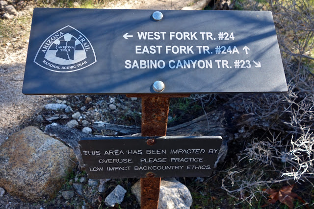
From the junction of the Box Camp and East Fork Trails, turn right. Walk 0.1 mile to the signed junction where the West Fork, East Fork, and Sabino Canyon Trails converge. Turn left on Sabino Canyon Trail.
 

Bust up a short incline and walk a few paces out to a promontory. From there you can study the route of the BCT below Apache Spring. Box Camp Canyon joins the East Fork just before its confluence with the West Fork and Sabino Canyon. 

The trail zigzags in and out of scallops on Sabino Canyon's east wall, contouring at 3,700 feet. The trail is smooth and fast. This remarkable passage has views extending from Mount Lemmon down into the constricted gneiss gorge. Round a corner and see Sabino Canyon Road and the Phoneline Trail under Thimble Peak. (THW, photo)

Descend the last 400 feet on switchbacks to the pavement at Shuttle Stop #9, elevation 3,334 feet. See the link at the top of this post for tram and fee information. Alternatively, it is 3.8 pleasant miles down the paved road to the visitor center and parking lot. There are bathrooms and drinking faucets at some of the shuttle stops, including Stop 8.

To Hirabayashi Trailhead: 5.7 miles, 1,600 feet of climbing
At the junction of the Box Canyon and East Fork Trails, turn left. The rest of the hike is on a section of the Arizona Trail. The trail makes two climbs. The first is to the saddle, shown, on the divide separating the East Fork and Sycamore Canyons. The treadway has a gentle grade and trampled clarity.
 

The Palisades Trail turns off at 8.1 miles. It heads uphill to meet the Catalina Highway near the Palisades Visitor Center. On top of the divide, 9.1 miles, 4,580 feet, go left onto the Sycamore Reservoir Trail. Shreve Saddle, the next climb, is on the east side of Gibbon Mountain, shown. In 0.1 mile, cross Sycamore Canyon creek and follow it all the way to the confluence with Bear Canyon. 
 

Take a spur trail to the dam built in the 1930's, 10.4 miles. The reservoir, pinched by the walls of Bear Canyon, is now filled with sand and silt but stone and cement structures, and sections of the water line remain.

Back on the Arizona Trail, the footpath kicks uphill to the top of a rise where an old road branches left. It looks like a shortcut to Shreve Saddle but it is more difficult than the trail. To the east is the multi-tiered Mount Lemmon Highway. Windy Point is located on the upper road wrap on the prominence, image-center-left. In the center is Seven Cataracts Vista and on the right is the Thimble Vista pullout. 
 

The 600 foot ascent to Shreve Saddle is on a classic trail built long ago with interspersed staircases to manage the grade. Half hidden in the brush are historic stone pillars that once supported the water line running from the reservoir to the prison camp.

Pass out of the Pusch Ridge Wilderness at Shreve Saddle, elevation 5,020 feet, 11.8 miles. It is located on the divide between Bear and Soldier Canyons. Descend gently through open grassland slipping in and out of the stone-dry upper Soldier Canyon waterway.
 

Molino Junction, 12.7 miles, is the location of the now abandoned Federal Prison Camp. Prisoners labored to build the Mount Lemmon Highway. During World War II, some of the prisoners were conscientious objectors. In 1942, Dr. Gordon Hirabayashi challenged the constitutionality of incarcerating Japanese Americans following the attack on Pearl Harbor in 1941. He was convicted and sentenced to serve at the prison camp now named in his honor. Structures have been removed but some foundations remain. Walk up one last little rise and you're at the trailhead.