Essence: On June 5, 2020, a lightning strike ignited the Bighorn Fire in the Santa Catalina Mountains. By July 23, it had incinerated 119,987 acres. Subsequently, higher elevation trails in the range were closed to travel by the Coronado National Forest. This multi-hike post details five lower elevation legal summits and one unranked point clustered in the Molino District. The half-day hikes are arranged by location relative to the Catalina Highway beginning with Mile Marker 2.6 and progressing up the road. The widely varied treks range from relatively easy trail hikes to challenging, off-trail scrambles. The desert grassland and Madrean evergreen oak woodland biome in this region is characterized by open terrain with wide-reaching vistas complimented by weathered granite boulder gardens, multi-faceted outcrops, balancing rocks, towers, and whimsical hoodoos. Some of the hikes are in the Pusch Ridge Wilderness; all are in the Coronado National Forest.
Travel: All five hikes leave from the Catalina Highway, aka Mount Lemmon Highway and General Hitchcock Highway. Mile Marker Zero is posted at the junction with Mount Lemmon Short Road. Measure distance from there.
Map: Agua Caliente Hill, AZ 7.5' USGS Quad
Quote: Look deep into nature, and then you will understand everything better. Albert Einstein
Mere moments, but a world away from Tucson, a path wanders between boulders and rock stacks. The rockpile, image-center, is Point 6,140', steps off the Bug Spring Trail. (Thomas Holt Ward, photo)
Route: The five hikes are on the Santa Catalina Front Range close to Molino Basin. With the exception of the off-trail, blue-line hike, the peaks are approached initially by established trails.
Mile Marker 2.6
Peak 5,471', Babad Do'ag Trail to Hirabayashi Thru-Hike, Black-Line Route
Essence: This is a short and sweet climb to a jagged and distinctive peak seen from all points surrounding Molino Basin. An out-and-back on the Babad Do'ag Trail exclusive of the mountain is ideal for trail hikers. The off-trail ascent on moderately steep slopes to the peak is for practiced scramblers with good navigation skills. A thru-hike to Hirabayashi shortens the trek but you could double back if you don't have a shuttle vehicle. The hike is within the Pusch Ridge Wilderness. No dogs, please.
Travel: Trailhead parking is at Babad Do'ag Vista on the east side of the highway at Mile Marker 2.6. This lot fills early on weekends. The thru-hike requires a shuttle. Drop a vehicle at the Gordon Hirabayashi Recreation Area, a signed left turn off the highway at Mile Marker 7.3.
Distance and Elevation Gain: 4.0 miles; 2,000 feet
Total Time: 2:45 to 4:00
Difficulty: trail, off trail; navigation moderate; mild exposure; Class 2+ scrambling
Date Hiked: January 22, 2021
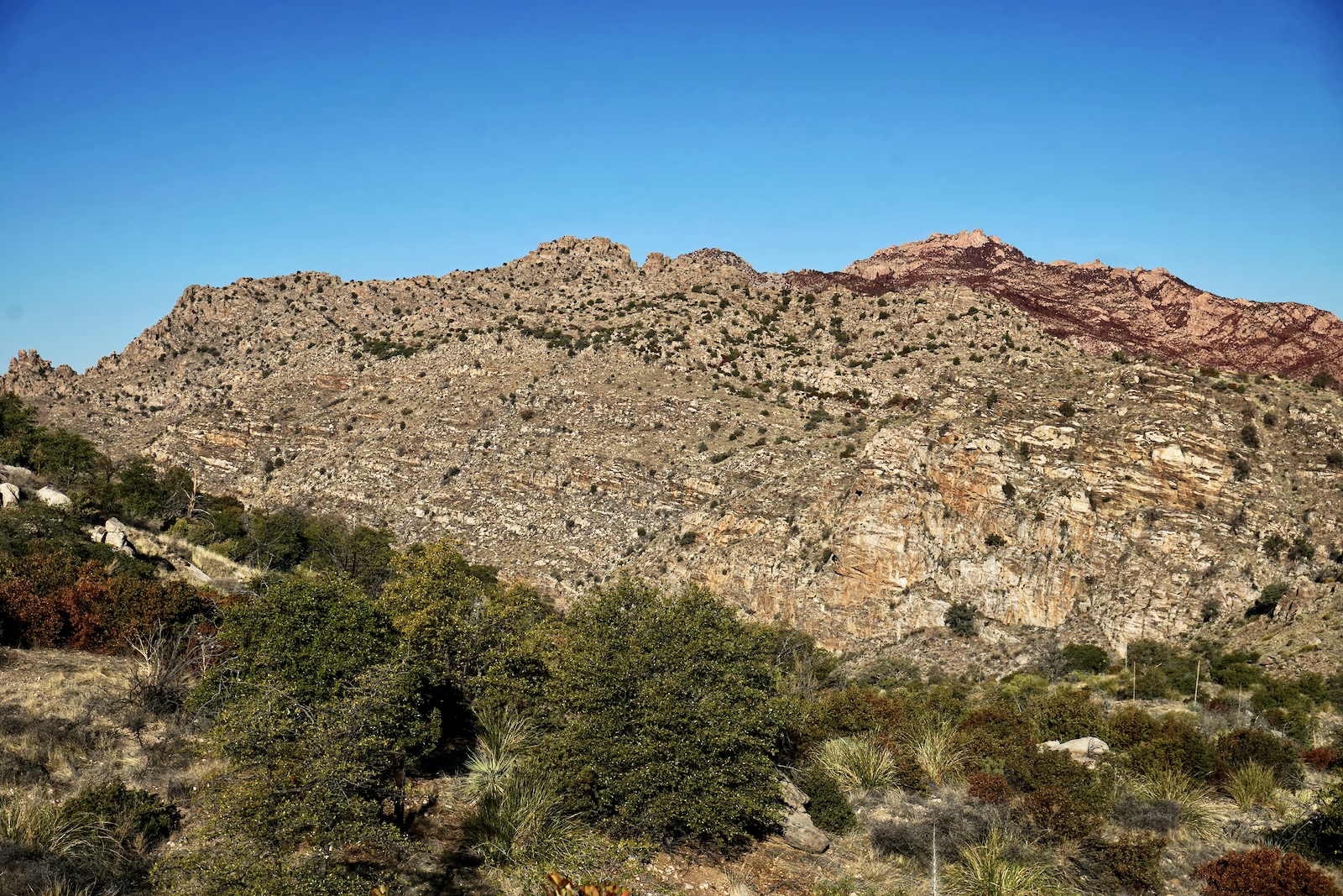
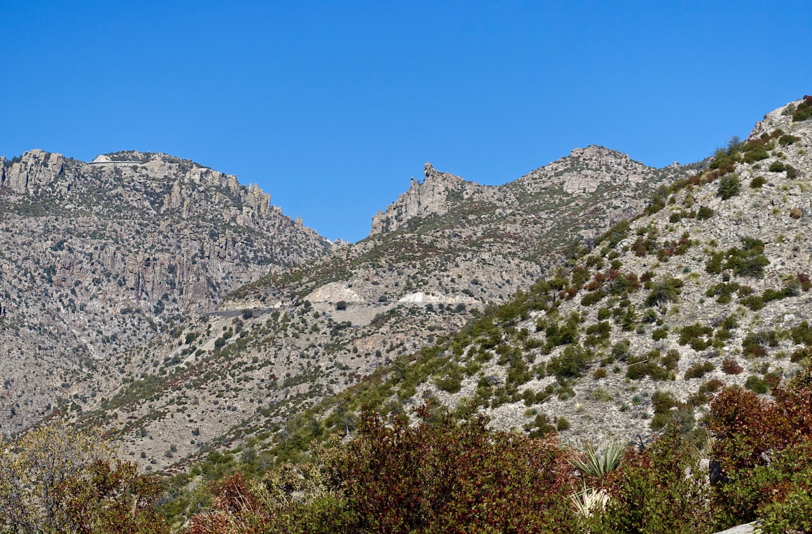
The linear summit ridge of Peak 5,471' is crowned by a cluttered mass of standing rocks. Seen from the north, not far from the Hirabayashi Trailhead, the mountain looks improbable for the hiker but there is a magic path.
Route: Hike roughly north on the Babad Do'ag Trail. The path flanks Point 4,780' on the west and returns to the ridgeline. Leave the trail and ascend the south ridge of Point 5,340'. Cross the Agua Caliente--Molino divide to the summit ridge of Peak 5,471'. Walk west to the crest. Descend on a climber's trail north to the Hirabayashi Trailhead.
This image was shot looking over to Peak 5,471' from a point east of Molino Canyon. On the left is Point 4,780'. Moving right is the ascent route to Point 5,340' with the pronounced cliff. The peak is the highest point on the horizon.
(THW, photo)
The Babad Do'ag Trail (aka Babat Duag) is prized by locals for its easy-going, graduated ascent while wandering to and fro following soft folds in the land. Babad Do'ag, "Frog Mountain" in the Tohono O'odham
language, is the tribe's traditional name for the Santa Catalina
Mountains.
From Babad Do'ag Vista parking, elevation 3,560 feet, the trailhead is located a few paces up the highway on the west side. Be careful and move quickly while crossing the road on a blind corner. The single track adheres to an old bulldozer road ascending the south-facing slopes of "MacDougal Ridge." The unofficial name refers to the MacDougal mammillaria cactus, a protected native plant found at mid-elevations. The cactus shown is a disk about eight inches in diameter. (The Santa Catalina Mountains: A Guide to Trails and Routes, Pete Cowgill and Eber Glendening, Rainbow Expeditions, 1997)
It simply amazes me time and again that the bedrock on the Catalina Front is uplifted at an angle accommodating for the hiker. The Sonoran plant community features staghorn cholla, ocotillo, Engelmann pricklypear, and many saguaro. There are sweeping views of Tucson and surrounding mountain ranges.
The footpath swings around the south ridge of Point 4,780' and flanks the west facing slopes high above a north fork of Agua Caliente Wash before returning to the ridgeline. The image below gives an overview of the climb from the trail to the top of Point 5,340', left of image-center.
At 2.2 miles, 4700 feet, leave the trail and climb north-northwest up a roller. (Trail hikers may continue a short distance west to a sign marking trail's end.) Ascend through desert grassland to a small grove of Arizona oaks. Hold your bearing as the climb steepens. High friction boulders hold the earth down. Quartz chunks coupled with bear, deer, and coyote scat are mixed together on the ground.
Confronted with a stone wall, move left and scramble up a small slot back to the ridgetop. Alight on singular Point 5,340' at 2.6 miles.
The stunning lookout is an exceptionally sweet spot with tremendous views over the landscape you just traversed. Now what? Head on is a significant cliff and the peak is on the linear east-west ridge across the jump. Move west no further than necessary, drop, and return to the ridge on a comfortable bench. Cross the Agua Caliente--Molino divide, shown, a perfect bridge (or charmed pathway) to the summit ridge. Once across the divide, head west dodging fascinating stone structures, pancake stacks and spires. (THW, photo)
On top of the summit stack at 3.0 miles, I felt a sense of incredulity, as if I was standing on the impossible. The two hikers below are looking west at the three summits of
Gibbon Mountain, Gibbon #1, #2, and #3.
To exit on the climber's trail to Hirabayashi, walk west down the summit ridge. Don't miss the subtle arch west of a tall, thin tower. At 3.3 miles, move left to get around an obstacle. Then look for the trail plunging off the north side of the spine. In the image below, the hikers are just about at the top of the trail. We wanted to play out the ridge so we continued on through a boulder garden to a westward overlook. Descending, paths spin off to bolted walls. Try to hold to the main track. It's quite steep, brace off the rocks. Closing in on the valley floor, the trail straightens in a runout zone. Intersect the Arizona Trail at 3.9 miles and turn right for the final paces to the trailhead at 4,840 feet. Thanks to my partner, Thomas Ward, for pioneering this route.
Mile Marker 5.6
Peak 5,166' (Molino South) From Molino Basin via the Arizona Trail (AZT), Purple-Line Route
Essence: Molino South presents its well-armored west slope to the Molino Curve. The AZT makes for a pounded and quick approach; this is the shortest and fastest hike in the set. Share the trail with intrepid mountain bikers. A quarter-mile-long social trail pitches up the north ridge to the summit. Stand on large boulders and take in a wide-flung vista of Tucson and neighboring ranges.
Travel: Molino Basin Campground and parking is located on the inside of a sweeping turn. Park in the lot on the west side of the road. Pit toilet, no water. No fee required for hikers on the AZT.
Distance and Elevation Gain: 2.5 miles; 800 feet
Total Time: 1:15 to 2:30
Difficulty: Arizona Trail, social trail; navigation easy; no exposure; Class 2
Latest Date Hiked: February 23, 2021
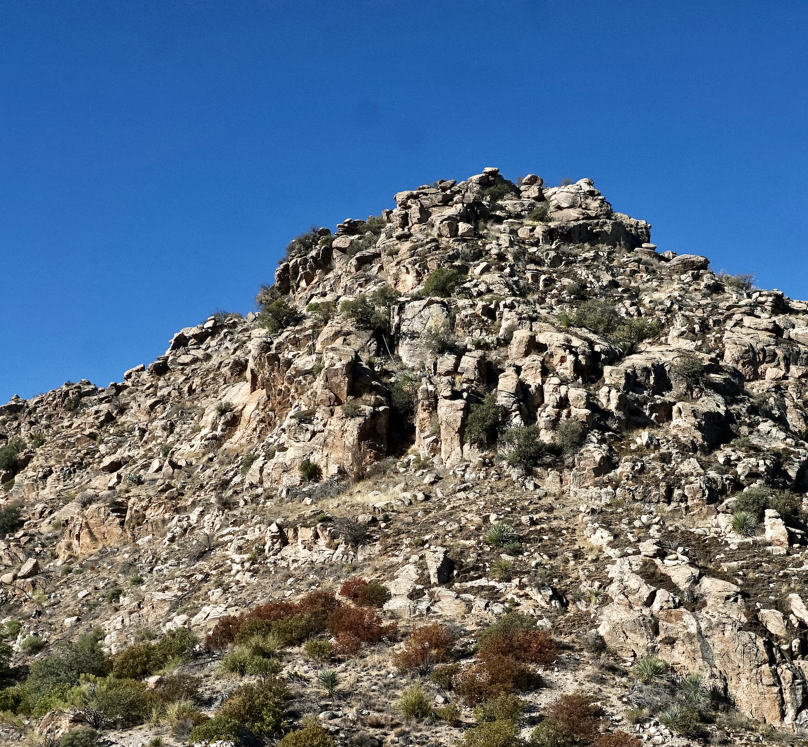
Peak 5,166' looks somewhat innocuous from Molino Basin but it is the highest point on the Molino-Agua Caliente divide south of the Arizona Trail.
Route: Ascend east on the AZT to a small saddle. From there, locate a social trail that busts up to the peak.
Scurry across the highway while watching for traffic and bicyclists rounding the fast corner. From the Molino Basin Trailhead, elevation 4,370 feet, hike east on the AZT making for the saddle, image-center.
Soon, cross Molino Canyon and begin the graduated ascent on a well-engineered, switchbacking trail composed of crushed granite and block steps. Living in the oak woodland is beargrass, yucca, sotol, pricklypear, shindaggers, and manzanita. It is mid-February and yet there are no flowers and even the heartiest plants are stressed, some dying, because of the unrelenting drought in Southern Arizona. There is much to take in topographically while climbing out of Molino Canyon. Morning light bounces off crenelated prominences too numerous to even rate acknowledgement as numbered points. To the immediate north, on the west wall of the canyon are three notable stone buttes, Point 5,968' ("The Thumb"),
Airmen Peak, and Point 5,820'.
After a quick mile reach the saddle, elevation 4,860 feet (giving the peak 366 feet of prominence). Open and close the gate or walk over the roll bar. The south spur to the peak begins right after the gate. The start of the footpath is deliberately obscured by slash, perhaps to discourage mountain bikers. Once past the initial obstruction the trail is clear. It must be stated that hiking on unofficial trails in the Coronado National Forest is legal. The slim path is all business, kicking up steeply for a quarter mile to the summit.
The crest is composed of large boulders and sitting slabs. Of the five hikes in this post, this handy crest has the best eastward vista. Below, the serpentine AZT heads La Milagrosa Canyon.
Agua Caliente Hill is only 200 feet higher than our perch. Mica Mountain and
Tanque Verde Peak meld into the horizon. Swing around to the west for an enticing view of Peak 5,471'. (THW, photo)
We did a Class 2+ scramble to the stone knob southwest to capture an image of Peak 5,166', seen below. The bushwhacking opportunities are endless from there. However, they all rate a higher order of difficulty relative to retracing your steps to the trailhead. The beautiful, soft green hue seen from a distance turned out to be tightly-packed shindaggers. (THW, photo)
Mile Marker 7.3
Gordon Hirabayashi Recreation Area, Shreve Saddle to Peak 5,506', Red-Line Route
Essence: Climb to the top of the world on a little mountain in a central space
surrounded by higher peaks. The out-and-back requires minimal effort--access the peak on an informal spur off the Arizona Trail. The optional, off-trail south
ridge return is more demanding; scrambling and some navigation savvy are required. The hike begins in the Coronado National Forest and enters the Pusch Ridge Wilderness at Shreve Saddle.
Travel: Drive past Molino Basin and turn left at the sign for Gordon Hirabayashi Recreation Area at mile marker 7.3. The trailhead is beyond the campground, 0.3 mile from the highway.
Distance and Elevation Gain: 3.4 miles with 780 feet of vertical for the out-and-back; 3.0 miles with 850 feet of gain for the south ridge return.
Total Time: 1:30 to 2:30
Difficulty: trail, off-trail; navigation easy; no exposure; the out-and-back is Class 2; the south ridge is Class 2+
Date Hiked: January 18, 2021
The conical shape of Peak 5,506', image-center, is most apparent from the Bug Spring Trail. Left of the summit is the stone prominence on the south ridge.
Route: Hike west and then northwest on the AZT to Shreve Saddle. Take a social trail northeast to Peak 5,506'. Return as you came or descend on the undulating and twisting south ridge to the bridge across Soldier Canyon.
The Hirabayashi Trailhead, elevation 4,840 feet, is on the west side of the large parking lot. Initially, the AZT doubles with the Molino Basin Trail. Pass by the now abandoned Federal Prison Camp. Prisoners labored to build the Mt. Lemmon Highway. During World War II, some of the prisoners were conscientious objectors. In 1942, Dr. Gordon Hirabayashi challenged the constitutionality of incarcerating Japanese Americans following the attack on Pearl Harbor in 1941. He was convicted and sentenced to serve at the prison camp now named in his honor. Structures have been removed but some foundations remain.
Come to a signed junction under a giant oak at 0.2 mile. Stay straight on the AZT, following the sign for Sycamore Reservoir, and cross Soldier Canyon on a stone bridge. The sandy footpath rises gently through open grassland slipping in and out of the stone-dry upper Soldier Canyon waterway
. Below, Peak 5,506' is the subtle highpoint image-left and the rock-strewn knob is on the south ridge.

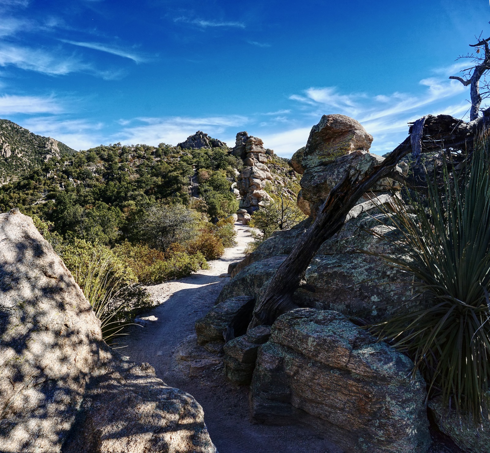
Enter the Pusch Ridge Wilderness at Shreve Saddle, elevation 5,020 feet, 1.1 miles. It is located on the divide between Soldier and Bear canyons. Leave the AZT here and bear northeast on a social trail up the ridge, shown. The trail braids; follow the strongest thread as it weaves around shindaggers and beargrass.
Taken from the first knob, this image looks back on the saddle named for Forrest Shreve, a desert plant ecologist. He served on the staff of the Desert Botanical Laboratory of the Carnegie Institution in Tucson for 30 years. He was director from 1929 to 1938. (THW, photo)
The trail becomes faint within 200 vertical feet of the summit. Simply hold to the ridge as best you can while scrambling up through granite boulders.
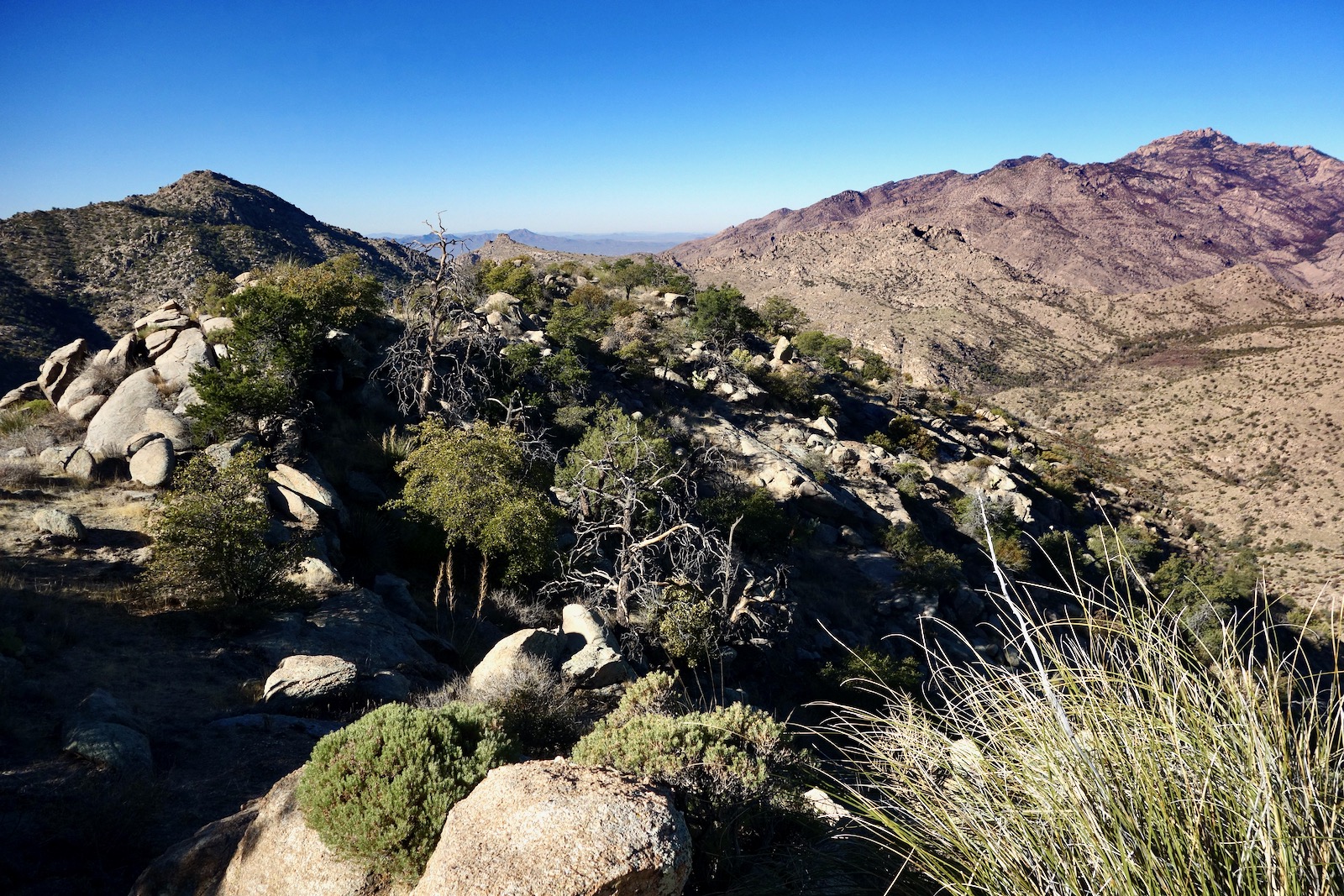
Round off on the linear summit ridge at 5,440 feet. The climb graduates but now boulders are packed together. You will feel like you are really climbing a mountain as you thread your way over and through the stone jumble-field. The ridge is sensational with expansive views off both sides. The summit is subtle but you'll know when you are there at 1.7 miles. There is much to see from the mountain in the center of everything. Gibbon Mountain is only 300 feet higher, image-left.
Cathedral Rock, image-right, commands authority on Pusch Ridge. You can both see and hear the Catalina Highway.
Trail hikers will want to simply retrace their steps. For those taking the more difficult south ridge, swivel on the summit to the southeast. Descend through a beautiful garden of stone, sotol, and yucca. Drop into the saddle and then mount up through big horizontal slabs of rock. Descend from the knob through a boulder yard.
The spine zigs and zags fairly radically; stay on the ridgetop. At 2.4 miles, 5,060 feet, hang a hard hook to the left to stay on the ridge. As you close in on the AZT, the ridge is broad and amorphous. We rejoined the AZT at the bridge across Soldier Canyon, 2.8 miles. However, the trail is visible for some distance so pick a route that appeals to you.
Mile Marker 7.7
Lower Bug Spring Trail to the Point 6,140' Rockpile, Orange-Line Route
Essence: The Bug Spring Trail is a 4.6 mile stretch between the Lower and Upper trailheads. The buff and lofty ridgeline trail is exceptional for its vistas and weathered granite formations. This hike features the lower and most scenic portion of the trail as it climbs to Point 5,698', the turnaround for trail hikers. Scramblers may pitch off-trail to the unranked Point 6,140' rockpile. The Bug Spring Trail is popular with mountain bikers; 95% are ripping downhill from the Upper trailhead. Reserve this hike for weekdays. If you must hike on weekends, drop a shuttle at Mile Marker 11.6 (just above Middle Bear) and do the thru-hike so you are heads up to bikers.
Travel: The signed parking lot for the "Bug Spring Trailhead" is on the east side of the highway at Mile Marker 7.7. This lot fills on weekends.
Distance and Elevation Gain: 5.4 miles; 1,250 feet
Total Time: 3:00 to 4:00
Difficulty: trail, off-trail; navigation easy; mild exposure; Class 2+ scrambling
Date Hiked: January 20, 2021
Two 20-foot-tall, free-standing columns are buckled down on a massive granite slab, a wash of rock, right on the Bug Spring Trail.
Route: The Bug Spring Trail begins with a lazy jaunt to the east before switching back to gain the northeast ascent ridge above Bug Spring. Cross a draw, and claim the southwest ridge of Point 5,968'. Leave the trail at the marked point and bushwhack northeast to Point 6,140'.
According to Cowgill and Glendening, the Bug Spring Trail historically connected the upper Bear Canyon Campground on the Mt. Lemmon Highway with the now abandoned Prison Camp at Hirabayashi. There has been a major reroute since Bug Spring was the main water source for Prison Camp and the trail no longer gets anywhere near the spring.
The Lower Bug Spring Trailhead, elevation 4,980 feet, is located at the south end of the parking lot. In less than 0.1 mile go left at the junction with the trail that comes up from Prison Camp. The crushed granite path weaves eastward through weathered boulders hanging on through tests of time. In 0.3 mile, the multi-purpose trail cranks back around and makes for the ridgetop at 5,260 feet. The loftiness of the spine is gratifying. Look over and up to Cathedral Rock but don't neglect the low elevation peaks in this post. They are all visible from this ridgeline trail except for Peak 5,166'. If you like granite, you will love this simple walk through boulder gardens, bedrock sheets, outcrops and hoodoos that have been standing for so long they've grown soft around the edges. Bug Spring is tucked out of sight in the deep drainage to the east. (THW, photo)
Cross a water-polished tributary of Soldier Canyon at 1.4 miles. If you can afford the time, take a 50-yard side trip downcanyon where you will discover a most unusual rock slab bridging the watercourse, image-center. It is possible to bypass a pouroff and crash down all the way to the highway but the brush is thick toward the mouth.
The trail transfers north to the adjacent ridge at 2.0 miles and resumes its journey to the northeast. The spine now runs parallel with the Bear Canyon divide topped by peaks 6,191' and 6,512' (see the next post). The ridge thins and the trail is bounded by whimsical and unusual rock features. This is the most enchanting segment on the Bug Spring Trail. (THW, photo)
At 2.5 miles, Point 5,968' is fairly nondescript. This is a good turnaround for trial hikers. You blew by it if you find yourself going down a series of steps. The image below was taken from Point 5,968' and shows the rockpile, 0.2 mile afar. Access is through the treed clef. Start out on the west side of ridge following the path of least resistance. It is brushy but not horrible. You'll likely find yourself back on the little spine and then slightly east of it.
This is a picture of the clef. Hug the stone wall and do a big-boulder scramble on sticky rock with good features.
Follow natural openings and you will arrive on the east side of the summit block toward the north end.
Cut through to the west side and work south on a substantial stone ledge. This puts you at the base of the summit boulders, shown. We did not attempt the exposed, technical climb.
Instead, we played around within our parameters of safety on the west side boulders.
Mile Marker 9
Peak 6,191' and Peak 6,512', Blue-Line Route
Essence: Climb two legal summits and a tower stack on a northeast-running ridge above Bear Canyon and the Catalina Highway. The wonder of weathering has created an array of astonishing stone features at this elevation on the Catalina Front. This is the most difficult of the five hikes in this post. Navigation is complicated, brush is thick, outcrops stand in the way, and scrambling is stiff. Retrace your steps from Peak 6,512' or thru-hike to the Upper Bug Spring Trailhead.
Travel: Mile Marker 9 is between Thimble Peak Vista and Seven Cataracts Vista. There is a long, paved pullout on the west side of the highway on the outside of a blind curve. Be very careful pulling over just shy of Mile Marker 9. For the thru-hike, drop a shuttle vehicle at Mile Marker 11.6, "Green Mountain, Bug Spring," just above Middle Bear.
Distance and Elevation Gain: 4.0 miles for the thru-hike; 1,800 feet
Total Time: 3:00 to 4:30
Difficulty: primarily off-trail; navigation challenging; mild exposure; Class 2+ scrambling; wear long pants
Date Hiked: January 16, 2021
Hikers on the Sycamore Reservoir Trail have an enthralling view of "Tower Stack" and Peak 6,191'. The highway rounds the corner and disappears into Bear Canyon only to reappear five miles further on, and 1,300 feet higher at Windy Point, image-left.
Route: Cross the highway and gain the southwest ridge of Tower Stack. Ascend to the minaret and then hike southeast to Peak 6,191'. Head northeast on a divide between Bear Canyon and one of its principal tributaries. From Peak 6,512', continue northeast and intersect the Bug Spring Trail.
Across the highway from the parking pullout, 5,280 feet, the cliff face appears impenetrable. But there is a weakness. Cross the road while watching and listening for vehicles and bicyclists. Walk a few paces downhill and locate a game trail directly under an Arizona oak, shown. Climb steeply for 20 to 30 paces.

Turn left/north and climb a steep hillside anchored with igneous granitic boulders, beargrass, and shindagger. Walk alongside an obvious outcrop, contour a short distance, and then climb to the ridgetop, plowing through manzanita. In the winter of 2021, the manzanita was severely stressed from the drought and many were dying. There were no flowers and even the junipers were desiccated.
Tower Stack
There is a lot of exposed rock in this altitude range and already, at 5,400 feet, I felt a sense of instant gratification. The usual rule applies--stay on the ridgecrest as best you can. In 0.3 mile, you will see what I am informally calling Tower Stack and Peak 6,191' to its right. We found a Class 2+ crack in the rock band seen below. As you near the saddle, climb along the base of Tower Stack.
Gain the ridge just southeast of Tower Stack at 0.7 mile, about 6,040 feet. Ascend a rippled ramp. (THW, photo)
Cross a solid rock bridge to the base of the stone lookout, 6,100 feet. The zenith is overhung and seriously exposed so we passed. Even so, this is one of the finest monuments on the Catalina Front.
Peak 6,191'
Descend to the saddle, 6,020 feet, and climb southeast on the ridge. Encounter a cliffband about 50 feet below the summit. Up the center is a Class 3 move but there are Class 2+ scrambles in the immediate area. It is just one mile to the summit. I got my hand on top of the stack but not my feet! My partner tucked a peak register in the pedestal. From this vantage point, all the peaks featured in this post are visible.
Peak 6,512'
The landscape to Peak 6,512', shown, is troubled with obstacles. The initial descent to the northeast is pure pleasure. Cross a field of stone.
Work your way down through outcrops. This image shows the Catalina Highway in Bear Canyon. Looking east you are likely to see bicyclists on the Bug Spring Trail.
Now in scattered piñon, we saw numerous piles of bear scat. Below, I am emerging from a stone doorway near the saddle at 5,860 feet, 1.5 miles. Peak 6,191' is in the background. (THW, photo)
The forces of weathering are on full display on this hike. (THW, photo)
This image looks back on Peak 6,191'. Note: if you are doing the out-and-back, do not try to flank Peak 6,191' on the southeast. We took a hard look at that from the Bug Spring Trail and the appealing bench pinches out at a rock wall. (THW, photo)
The highpoint of the linear summit ridge is at 2.6 miles. It is lightly forested with piñon and juniper but the views are superb. See the highway climbing to Windy Point on one side and Mica Mountain on the other.
Upper Bug Spring Trailhead
We had every intention of returning as we came but decided spur-of-the-moment to see if we could create a thru-hike by linking with the Bug Spring Trail. The north ridge descent began easily enough but we had to contend with the "hoodoo pile" seen below. Flank it right under the northwest wall and then get back on the ridgeline. This one obstacle is significant enough to deter people from thinking of Peak 6,512' as easy prey from the trail.
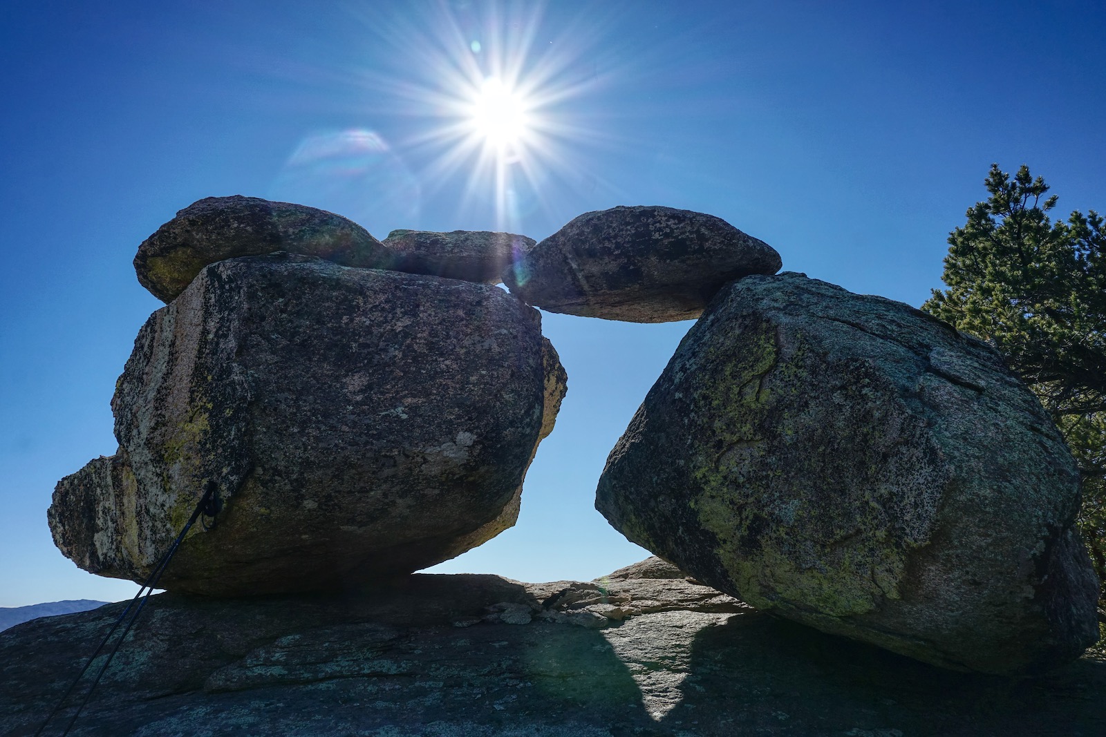
Forces at work over time, boulders precariously balanced and leaning on each other, and even the space between, emit a strong presence. (THW, photo)
We crashed our way successfully down to the trail at 3.4 miles. Climb 100 feet and it's a short, pleasurable downhill on a buff track to the Upper Bug Spring Trailhead. Hit the Catalina Highway at 4.0 miles. Since we were not anticipating a thru-hike, we walked down the road for 2.7 miles to our point of origin. The traffic was continuous on a Saturday and it felt rather harrowing so avoid it if you can.