Monday, January 31, 2022

Big Hatchet Peak, 8,356', New Mexico Bootheel

Essence: The sheer force of Big Hatchet Peak cleaves the horizon, beckoning desert wanderers traveling throughout southwestern New Mexico. The state's eighth most prominent peak is located in the remote Bootheel, a borderland block protruding into Chihuahua, Mexico. The journey begins with a rugged drive through the fierce beauty of the Chihuahuan Desert. The track rises from creosote bush bottomland onto a mesquite bosque bajada and on up into a piñon-juniper woodland. A strong social trail takes the hiker to the dip slope of the master mountain. From there, the ascent is gradual and accommodating through limestone boulders sheltering symmetrical agave. From the highpoint of the range, the full-circle vantage point encompasses sky islands of southeastern Arizona, the Sierra Alta range in Chihuahua, and the imponderable Sierra Madre Occidental in Sonora, Mexico. The Continental Divide Trail parallels the Big Hatchet Mountains on the northeast. This will likely be a hike of solitude, though thru-hikers occasionally sign the summit log. The hike is within the Big Hatchet Mountains Wilderness Study Area administered by the Bureau of Land Management.
Travel: A 4WD vehicle with high clearance is required to reach the trailhead. We followed a friend who had perfected the route. Three highways intersect in Hachita: NM-146 comes south from Exit 49 on I-10. NM-9 runs east-west through town. NM-81 begins in Hachita and goes south to the Port of Entry at Antelope Wells. The Hachita Food Mart and gas station (call ahead to confirm) is a happening place. Measure distance from the intersection of NM-9 and NM-81 and go south on NM-81 toward Antelope Wells. Big Hatchet is straight ahead while driving through the Hachita Valley. At 10.4 miles (between Mile Marker 34 and 33), turn left on Hatchet Road, CR 95. It's dirt from here on. At 11.0 miles, take the right fork. Turn right at 13.1 miles on Commodore Road. There are a maze of roads; stay on the main track, one lane with washboard. At 16.2 miles, four roads intersect. Go left, following the sign for Public Land Access. Enter the Wilderness Study Area. It might feel like you are going too far east. Stay on route. At 21.4 miles, the road splits. Take the right branch (straight ahead) and start up Thompson Canyon. Pass a square, stone water tank filled with water. The road degenerates, becoming rocky and narrow. Cross the Continental Divide Trail at 22.4 miles. As the track climbs the alluvial fan, mesquite will scrape your vehicle. Consider parking in a turn-around lot at 23.7 miles. Clearance issues become strained from there. The road dips in and out of radically pitched narrow ravines. Excellent approach and departure angles are required. Park at the end of the road, mile 25. Allow 1:15 from Hachita. Note: the road through Thompson Canyon is prone to washout and you may have to park some distance from the trailhead.
Distance and Elevation Gain: 5.4 miles; 2,650 feet of climbing
Total Time: 4:30 to 6:00
Difficulty: Trail, off-trail; navigation moderate; Class 2; no exposure (precipice can be avoided)
Maps: Hatchet Ranch, Sheridan Canyon, U Bar Ridge, Big Hatchet Peak; New Mexico 7.5' USGS Quads
Date Hiked: January 31, 2022
Quote: We tend to think of landscapes as affecting us most strongly when we are in them or on them, when they offer us the primary sensations of touch and sight. But there are also the landscapes we bear with us in absentia, those places that live on in memory long after they have withdrawn in actuality, and such places--retreated to most often when we are most remote from them--are among the most important landscapes we possess. Robert Macfarlane
 
The block-faulted Paleozoic limestone cliffs of Big Hatchet Peak upthrust four thousand feet above the Playas Valley. The Omnidirectional Relief and Steepness system for measuring mountains ranks Big Hatchet number one in New Mexico. (Thomas Holt Ward, photo)

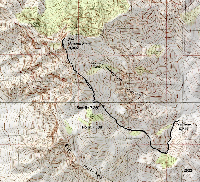
Route: From the trailhead ascend south on a footpath along a tributary of Thompson Canyon. The route swings northwest. Upon reaching the saddle between Point 7,500' and Big Hatchet Peak, climb the south ridge off-trail to the summit.
 
Hachita was a vibrant mining town in the late 1800s. Currently, the dilapidated village has about 50 residents. A stone mason's mastery withstands the ravages of time at St. Catherine of Siena Catholic Mission Church. According to the shop keeper at the convenience store, the diocese stripped the statuary from the building in the early 2000s and has no intention of revitalizing the beautiful sanctuary. (THW, photo)
 
The climber's blade, the south ridge of Big Hatchet Peak, is visible from Hachita. Zeller Peak, 7,426', is the domed subsidiary summit west of the highpoint.

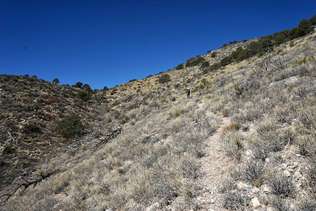
Judging from trip reports, the trail was faint and fragmentary for decades. In 2022, while it was slightly overgrown and showed little sign of use, the boot-worn treadway was dependable and an indispensable assist navigating to the saddle. Two forks of Thompson Canyon, from the south and southwest, converge in the vicinity of the unsigned Big Hatchet Peak trailhead, elevation 5,740 feet. The route goes up the south fork, image-left. The trail leaves from the west end of the parking area,
immediately drops into the ravine and pitches up the other side.

It crosses the dry arroyo at 0.1 mile and then recrosses several times.
 
Limestone cliffs of the Paleozoic Era (541-252 million years ago) surround and embrace the hiker. You will be in the company of this square-block peninsula for most of the hike.
 
The Chihuahuan Desert ecoregion is the largest in North America covering nearly 250,000 square miles; most of it lies south of the U.S.-Mexico border. It is considered the most diverse desert in the Western Hemisphere. Within the canyon and on north-facing slopes are elder piñon-juniper stands and sandpaper oak. Ubiquitous mountain mahogany is coupled with evergreen sumac, silktassel, and glistening beargrass. The fruits of cane cholla are eaten by desert bighorn sheep which are known to roam in the Big Hatchet Mountains.
 
At 0.5 mile, the route leaves the drainage, curves to the northwest and ascends toward Point 6,449' on a crushed rock treadway. In the adjacent drainage the New Mexico Department of Game and Fish has installed an elaborate system for supplying water to wildlife. The tanks are visible from the trail.
 
Pass a magnificent limestone breccia boulder. Breccia is composed of pebble and boulder-sized clasts cemented together by a fine-grained matrix. The angular nature of these clasts indicate they have not been transported very far from their source. Our geologist companion surmised we were in the fault zone.

At 0.8 mile, pass over a small ridge west of Point 6,449'. The trailhead and our vehicles are pictured in the center of this image. The trail rounds the corner and ascends the upper reaches of the southwest fork of Thompson Canyon.

Pass under the squared peninsula. Intimidating crucifixion thorn edges the path. (THW, photo)
 
The trail crosses the ravine at 1.3 miles and climbs aggressively up the draw between Point 7,500' and the peninsula. On the return, this stretch was toe-jamming steep. (THW, photo)

Gain the broad south ridge of Big Hatchet at 7,320 feet, 1.7 miles. This cairned juncture is above the 7,260-foot saddle and slightly north of the insignificant rise, Point 7,299'. The route up the south ridge is off-trail from here to the summit.  

The way is clear and there are no obstacles. We found crinoid fossils embedded in limestone boulders. 
 
Cabbage head agave (a. parrasana) are abundant on the ridge. Native to Mexico, they favor limestone soils.
 
Within a half mile of the top, the dip slope narrows. Typical of a tilted fault-block, Big Hatchet has a phenomenal crashing drop to the west. You can moderate how close you come to the precipitous escarpment. It's easy to fall in love with this "hostile" landscape while walking along the thrilling, airy cliffline. 

Arrive on the roomy summit at 2.7 miles. While we found reference marker No. 2 placed in 1938, the Big Hatchet benchmark was missing from its post.  (THW, photo)

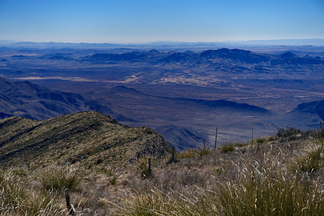
There is a solar powered weather station on the summit and an entertaining peak register. The most noble entry was posted by a hiker who was lamenting his last day on the Continental Divide Trail. Earlier the same year, he hiked the entire Appalachian Trail. Wow. The field of vision is commanding if not other-worldly. Look south into the swallowing distances of Sonora and the Sierra Madre Occidental, "Western Mother Mountain Range." (THW, photo)

To the west is the Playas Valley and Peloncillo Mountains of New Mexico, and the snow-capped Chiricahua and Pinaleño mountains in Arizona.
 
At 8,565 feet, Animas Peak is the highpoint in Hidalgo County, New Mexico. The Animas Mountains sky island is privately owned by the Animas Foundation and is off-limits to hikers.
 
The Alamo Hueco Mountains are but a breath away from the international border. South of the range is the state of Chihuahua.

Walk along the free-fall, overhung north face to sense the empty space surrounding this mountain on three sides and for a captivating view of Zeller Peak.
 
Descending the south ridge, I paused to consider the wonders Earth creates by moving large crustal blocks.
 
Looking at the image below, the squared off peninsula is on the left, Point 7,500' and the saddle are on the right, and the descent draw is image-center. The tempting peninsula drew one in our group off course. When you get to the saddle area, watch for the cairn marking the trail into the draw at 3.7 miles. In 2022, there was no snow in January, not even in the north slope woodlands.
 
It is a long haul from anywhere to Big Hatchet Peak. Remote has its advantages. This is a windshield shot of the setting orb finding an opening (briefly!) in a brooding sky to set grasses blazing along AZ-338. 

Thursday, January 27, 2022

Mount Bruce, 6,087' ("The Biscuit"), and Peak 6,162', ("North West Dome"), Mustang Mountains

Essence: Mount Bruce, known colloquially as "The Biscuit," grabbed my attention while bicycling between Sonoita and Bisbee. The two ranked peaks described here are located at the northern end of the Mustang Mountains, a small limestone sky island south of the Whetstone Mountains and north of the Huachuca Mountains. Surrounded by vast tracks of rangeland, the Santa Rita Mountains are off in the west and the Dragoon and Chiricahua mountains are to the east. The domed summit of Mount Bruce rises above a vertical, curvilinear sheer wall. By circumnavigating the mountain, we discovered a direct route on a faint climber's trail up the north slope at a break in the barrier wall. However, the slope is steep and both boulders and exfoliated rubble are on the loose. There is an option to climb adjacent Peak 6,162', "North West Dome." The hike is on Bureau of Land Management and Arizona State Trust Land.
Travel: From I-10, take Exit 281 (Sonoita/Patagonia) and drive south on AZ-83. The beautiful, curvy road affords views of Mount Bruce and the layout of the Mustang range. Arrive in Sonoita at 24 miles and turn east on AZ-82. In 8.3 miles, turn south on paved Upper Elgin Road. At 2.4 miles, there is a windmill and circular water trough on the west side of road and a gate on the east. Turn left and open and close the gate. In a few yards the road splits. Take the left fork heading north. The dirt two-track is hemmed in by tall grass. The road is flat except for a couple of ruts--2WD with moderate clearance should be capable. A road comes in from the right at 0.8 mile. Stay straight. At 0.9 mile park on the near side of a locked gate. Display your Arizona State Trust Land permit. Driving time from Kolb Road and I-10 in Tucson is one hour.
Distance and Elevation Gain: Mount Bruce out-and-back on the most direct route: 3.8 miles, 1,300 feet. There are multiple descent routes from North West Dome. The east ridge descent, plus Mount Bruce: 5.8 miles; 1,850 feet
Total Time: 3:00 to 5:30 depending on route
Difficulty: Jeep track, primarily off-trail; navigation moderate; Class 2+; steep, loose slopes; carry all the water you will need and hike on a cool day.
Maps: Elgin; Mustang Mountains, AZ 7.5' USGS Quads
Date Hiked: January 27, 2022
Quote: A prairie is by nature trembling, being made of grass. The phrase (trembling prairie) seems to describe an interesting quality of optical illusion, that rising shimmer over a vast expanse of disparate entities, which, in the tumbling liquid motion of the wind, gives a panorama the appearance of a single living thing. Susan Brind Morrow (Home Ground: Language for an American Landscape)
 
The upthrusting cliffs encircling isolated Mount Bruce appear even more extraordinary when seen from the north ridge of North West Dome. (Thomas Holt Ward, photo)

Route: From parking, walk north on the incoming road and turn sharply east on a two-track to approach the west slopes of Mount Bruce. Ascend a climber's trail to the base of the west-facing cliff. For the most direct route, flank the west side of the mountain to the north slope. Climb south to the summit. Retrace steps. For North West Dome, descend to Saddle 5,630'. Climb the north ridge to the summit. Our descent route on the east ridge was steep and rubbly. Instead, descend on the west slope. Note, the contour interval for both quads is 25 feet. 

From the gate on Upper Elgin Road, the four principal peaks in the Mustang Mountains are silhouettes in morning light: Mount Bruce, North West Dome, Mustang Peak (6,317'), and Mustang Mountains High Point (6,469').

Driving to the start of the hike, straw-colored grasses are a world unto themselves.
 
The maze of roads throughout the area pose a potential navigational conundrum for your return. The two low hills northwest of the parking area are helpful landmarks. (THW, photo)

Mount Bruce, 6,087'
From parking, elevation 4,975 feet, squeeze through the locked gate and enter a swath administered by the BLM. Walk north for 0.2 mile and then cut east on an intersecting two-track. Living on the savanna are agave, soaptree yucca, prickly pear, and clumps of hearty beargrass. As the land draws onto the bajada, it supports ocotillo, buckhorn cholla, and mesquite. The grass has been trampled in small patches under the trees by cattle seeking scraggly shade.
 
The road ends at 1.0 mile. The one trip report we found was Sirena's Wanderings. In 2012, she and the Huachuca Hiking Club climbed The Biscuit from its south saddle. That was our intention. However, at road's end we deciphered a cairned and rock-lined climber's trail pitching up the west slope. We followed the footpath out of curiosity. Unexpected trails that serve well are gifts. As we closed in on the  wall, a bighorn sheep took flight. Be on the watch also for harrier hawks and a colony of swifts. 
 
Looking back from high on the western slope, you can see the two-track coming east from the two low hills. The 45,000 acre Las Cienegas National Conservation Area spans between the Mustang and Santa Rita mountains. Cienega Creek runs through the center of the playa. 
 
The trail kicks up as it closes in on the wall, the surface coated with exfoliated pebbles. Within 100 vertical feet, the powerful silent presence of stone being envelopes the hiker. Reach the base of the wall at 1.4 miles, 5,800 feet. A rope with hand loops was anchored to the overhung cliff. Consult Mountain Project if you are curious about climbing routes on The Biscuit. This website warns climbers to beware of rattlesnakes and Africanized bees. While we lamented the complete absence of blooming flora in January, it was freeing to have no concern for snakes and bees. 

The limestone is composed of razor-sharp surface karst and chert nodules. (THW, photo)
 
We knew there was a break in the cliffband on the north slope. We didn't immediately see sign of a use trail on the west side of the mountain so we stuck with our original plan to flank the escarpment on the east side. I will describe our circumnavigation but having been all the way around, the quickest route to the summit wraps along the base of the west wall. It is just half a mile from the top of the climber's trail to the crest. In summary, bear north and in a few feet a social trail will materialize. There will be some sidehilling and about 100 feet of elevation loss for cliff avoidance. Follow the trail as best you can and in 0.2 mile you will be in the vicinity of a plaque dedicated to Charles Bruce. Do a rising traverse and in about 0.05 mile you will contact the faint summit trail.
 
Meanwhile, we curved around at the base of the wall to the east side. The footing is a bit tricky on rickety talus. Hug the wall while moving north. Across Rain Valley to the northeast, Apache and French Joe peaks share the highest ridgeline in the Whetstone Mountains. (THW, photo)

 When the scarp began to break we started up a subtle northeast ridge, 1.7 miles. (THW, photo)
 
We hoped to scale the ridge clear to the summit but our first attempt repelled me on skittish, exposed Class 3 stone. I found the terrain challenging--both small and large material is loose; it is very steep and brushy. Now on the north side of the mountain, we maneuvered west looking for any opportunity to initiate our climb.
 
We began scrambling in earnest just before the escarpment sealed back up. It wasn't ideal, but it was our final opportunity, shown.

At 5,900 feet, we happened upon the cairned use trail. We passed through a gateway cairn at 6,000 feet. Twice on this hike we got lucky and stumbled on social trails. This one turned a substantial challenge into a pleasant ascent. We rounded off on the summit at 1.9 miles. Having encountered no one, we were astonished to find a solitary climber from our hometown on the mountaintop. (THW, photo)

A large bivouac occupies the center of the circular vantage point. The vertiginous cliff band lies below the rounded summit cone so the thrill of a sharp rim isn't present. However, with a rise of 457 feet, there is a sense of altitude. The vista on our clear-sky day was remarkable. Swinging north from the Santa Rita Mountains, we could see the Santa Catalina Mountains, the Rincons, Whetstones, Dos Cabezas Peaks, Cochise Head in the Chiricahua Mountains, the Huachucas, and the compelling summits of Mexico. The peak register contained only a few yearly entries. (THW, photo)

To the immediate south was our next quest, North West Dome. (THW, photo)
 
Descending, we followed the trail reliably to about 5,800 feet where it became fragmented. On a lark we decided to circumnavigate The Biscuit so we went west. This proved fortuitous because we happened upon a bronze plaque erected in 1922 by friends and fellow pioneers of Charles Bruce, nearby cattleman and Secretary of Arizona Territory. It is mounted on the stone wall at about 5,700 feet. It reads, in part, "This mountain was named Mt. Bruce by the Board of Supervisors of Pima County...adopted in July 22, 1893, in recognition of the record of Charles Morelle Bruce as a pioneer in the first settlement of the county by citizens of the United States..." (THW, photo)

From the plaque, we worked our way back up to the base of the wall and closed the loop at 2.4 miles. If Mount Bruce is your sole destination for the day, simply scamper back down the climber's trail to the incoming two-track. If you'd like to explore further in the Mustang Mountains, North West Dome is just 0.6 mile afar.

North West Dome, Peak 6,162'
Curve around to the south and make your way down to the Mount Bruce-North West Dome saddle at 5,630 feet. Of note: we did not see evidence of a trail coming to the saddle from the west. The ascent on the north ridge is more gradual than anything on The Biscuit. Upon reaching the outcrop, shown, we skirted it briefly on the west before returning to the ridge. The composition of the rock shifted to well-seated sandstone which made scrambling a pleasure. 

This image looks back on Mount Bruce. Our hometown friend, standing just left of the west wall puts the enormity of the perpendicular cliffband in perspective.
 
Mount the first false summit and enter a peaceful park. 
 
Scramble up the second false peak which is a bit higher than Mount Bruce. (THW, photo)
 
Walk through a cluster of standing rocks to the crest of North West Dome at 3.0 miles. We found clothing and water bottles discarded by migrants on the summit. I don't know the history of the informal name found on Lists of John. The website gives the peak a precise elevation and lists the rise as 925 feet. The summit is more linear than dome-like. There is a small weather station on top.

From North West Dome the view corridor opens to the southern portion of the range, specifically Mustang Mountains High Point and Mustang Peak. Sierra San Jose in Mexico is visible through the wedge between them. The Huachuca Mountains dominate on the right. The Babocomari River runs south of the range, flowing east to the San Pedro River. San Ignacio Del Babocomari is the largest contiguous private land parcel in Arizona, at nearly 28,000 acres. The original land grant was issued in 1832 to the Elias family by the Republic of Mexico. The website notes that the Babacomari Valley rangeland has been supporting livestock since Europeans first ventured into this "terra incognita" in the 17th century. (THW, photo)

For the return, we wanted to continue exploring so we went down the east ridge to 5,900 feet and then turned south until we contacted the saddle with Mustang Peak. I do not recommend our descent route. Rather make you way down the gentler west slopes of North West Dome, the most direct strategy. Our route, shown on the map above, was prone to steep side hilling with boulders rolling out from underfoot. We dodged cliffs, cactus, and shindaggers. The image below shows our descent route, viewed from the saddle at 5,240 feet.

We headed west through open grassland, eventually aiming for a large water tank where we meet a functioning two-track.
 
From the tank, we were able to walk on a series of roads back to the parking area. This image looks across the midday prairie to viable west slope descent routes from North West Dome.