Essence: Palomino Mountain is a formidable looking structure--a collection of towers, blocks, and three, free-standing fins. Aylor's Arch is a delicate window in the slender and lengthy easternmost fin. The mountain was born of volcanism and the raw bones that remain are composed of welded tuff. Having seen Palomino from Black Top Mesa, I wasn't at all confident I could summit. But the mountain wants to be climbed. To pass between the fins is to be embraced by stone. To balance on the summit blade is pure joy. The approach from First Water Trailhead is long relative to the off-trail spur. With a rise of 280 feet the mountain is just 20 feet shy of qualifying as a ranked summit. The Superstition Wilderness within the Tonto National Forest was
designated in 1939 and expanded to 160,200 acres in 1984.
Travel: From the intersection of Lost Dutchman Boulevard and Apache Trail (AZ 88) drive north along the western front of the Superstition Mountains. Pass the Lost Dutchman State Park turnoff at 2.8 miles. A brown sign for First Water Trailhead precedes a right turn at 3.2 miles onto First Water Road, FSR 78. Reasonable clearance is needed on the lumpy dirt road. There are several wash crossings; do not attempt when flowing. Park at 5.8 miles. The large lot fills on weekends. Pit toilets, no water, no fees.
Travel: From the intersection of Lost Dutchman Boulevard and Apache Trail (AZ 88) drive north along the western front of the Superstition Mountains. Pass the Lost Dutchman State Park turnoff at 2.8 miles. A brown sign for First Water Trailhead precedes a right turn at 3.2 miles onto First Water Road, FSR 78. Reasonable clearance is needed on the lumpy dirt road. There are several wash crossings; do not attempt when flowing. Park at 5.8 miles. The large lot fills on weekends. Pit toilets, no water, no fees.
Distance and Elevation Gain: 10.7 miles; 1,700 feet
Total Time: 6:00 to 7:30
Difficulty: Trail, 8.8 miles; off-trail, 1.9 miles (allows for exploring all three fins); navigation moderate; Class 3 with considerable exposure on the summit fin. Some brush, long pants recommended. Streams may be running but don't count on it--carry all the fluids you will need. Hike on a cool day.
Map: Goldfield, AZ 7.5' USGS Quad
Date Hiked: November 20, 2022
History: Chuck and Peg Aylor were old-time prospectors in the Superstitions in the 1940s. "Aylors Caballo Camp" was designated on the 1956 Goldfield topo. It was located along the Dutchman's Trail in East Boulder Canyon just south of the junction with the Bull Pass Trail. Some storytellers call the arch, Eye of the Horse or Caballo Ojo. From: Hiker's Guide to the Superstition Wilderness, by Jack Carlson and Elizabeth Stewart, Clear Creek Publishing, Tempe, 2002.
Poem:
This land is a poem of ochre and burnt sand I could never write, Poem:
unless paper were the sacrament of sky, and ink the broken line of
wild horses staggering the horizon several miles away. Even then,
does anything written ever matter to the earth, wind, and sky? Joy Harjo
wild horses staggering the horizon several miles away. Even then,
does anything written ever matter to the earth, wind, and sky? Joy Harjo
Palomino Mountain is west of Black Top Mesa and northwest of Weavers Needle, standard-bearer of the Superstition Mountains. Visually, Palomino presents a complex maze of possible routes. They all dead end except for one. And therein lies its appeal and its magic. (Thomas Holt Ward, photo)

Route: From First Water Trailhead hike southeast on the Dutchman's Trail. Shortly after the junction with the Black Mesa Trail, hike off-trail south in Little Boulder Canyon. Pass through a constricted notch and then launch east on a cairned route to the three-fin summit platform. Scramble over to the east fin and climb north to the summit. The three principal fins are on a northwest slant. For ease of discussion I simply refer to them as the west, middle, and east fins. Note: The Goldfield quad has 20-foot contour intervals.

The Dutchman's and Second Water trails both leave from the First Water Trailhead, elevation 2,280 feet, and head southeast. Initial steps on boot-worn, ash-flow tuff lead immediately into the Superstition Wilderness. Weavers Needle, the indomitable orientation landmark, is visible right away.

The broad trail, an abandoned road to start, is hemmed in by vegetation typical of the Sonoran Desert: saguaro, jojoba, brittlebush, hedgehog cactus, pricklypear, paloverde, teddybear cholla, and exuberant stands of chainfruit cholla.

The Superstition Mountains were constructed by volcanic activity 25
million years ago. The welded tuff formation seen north of the trail painted with brilliant
lime-colored lichen is
volcanic ash cemented under extreme heat.

Second Water Trail branches to the left at 0.3 mile. Stay on the Dutchman's Trail. Cross a tributary of First Water Creek at 0.5 mile. The fascinating stone towers and assorted oddities west of the trail are composed of rhyolite, extrusive igneous
rock associated with volcanism. (THW, photo)

Cross First Water Creek at 1.1 miles and recross several times on water-tossed, rounded boulders. The trail pulls out of the drainage and ascends to unsigned Parker Pass, 2.6 miles, 2,630 feet. There's a nice, if distant, view west to the Goldfield Mountains. Head down the other side and our quest comes into view--in an optical illusion sort of way. From this perspective, it's almost impossible to distinguish Palomino Mountain (right of image-center) from the armored escarpment of Black Top Mesa.

Much of the trail beyond the pass travels over
weathered "Superstition tuff." The smooth surface contrasts with the enchanting bubbles of stone formation north of the trail.

Enter Boulder Basin, an extended flat area. Boulder Canyon flows north from the basin into La Barge Creek which empties into Canyon Lake. West, Little, and East Boulder canyons all flow north out of the high mountains and converge in Boulder Basin. (THW, photo)

Take a moment to study the wondrous and broken north face of Palomino, seemingly all spines, slivers, and standing stones. My initial reaction was, "I'm not getting up that." But there is a reasonable route and that's a big part of the mountain's charm. The passage is up through the yawning gap between the middle and west spines, right of center in the image below. (THW, photo)

Arrive at the junction with the Black Mesa Trail (joining from the northwest) at 4.4 miles, 2,290 feet. The junction precedes what's indicated on the topo. We're close, but not quite at the turnoff for Palomino. 

Continue a few paces, 0.05 mile, on the Dutchman's Trail. (It continues southeast to the Peralta Trailhead.) There is a row of insignificant hills to the south. The first objective is a low saddle between two small hills. The launch point is from an open flat with a sawed off tree. In 2022, there was a major stone fire ring and a small, subtle cairn on the south end of the flat. The route is off-trail from there.
The summit is only 0.85 mile afar and it took us just over 45 minutes each way. However, we burned two miles and three hours total with all our horsing around on the fins.
Turn 90 degrees to the south aiming for the saddle indicated with an arrow below. There were no cairns in 2022 but we were able to weave easily between the plants.

From the saddle, 0.1 from the turnoff, work down into Little Boulder Canyon and rock hop upstream. There were pools of water in bedrock pockets. Watch the catclaw--long pants are recommended. Walk into the squeeze seen below. (THW, photo)

The canyon is pinched between sharp, scraggy, untamed walls composed of rhyodacite. The image below looks back on the cramped canyon. (THW, photo)

Emerge from the short narrows at 4.8 miles and immediately launch east up a broad gully, shown. On our trek the route was well-cairned to within 100 vertical feet of the flat between the west and middle fins. Absent cairns, you could forge a way but it was nice (and unexpected) to be guided on the most efficient and pleasant route. As always, we rebuilt fallen cairns on our descent.

The gully
broadens into a draw and then a bowl with massive stone structures. We didn't know what to expect which made the moderately steep climb all the more enthralling and pleasant. Aylor's Arch is encased in an ever so fragile fin, a pure and open aperture to the brilliant blue sky.

There are many opportunities to see the arch but the best vantage point is from the ascent bowl. (THW, photo)

As the route proceeds to the rim of the bowl it is forced to the right of the stone sliver clinging to the middle fin.
(THW, photo)

The passage tightens dramatically and tunnels through thick brush. The incline steepens at 2,600 feet. The hardscrabble surface is slippery. Embedded rock secures footing through this short section. The corridor is tiny and yet there are no insurmountable obstacles. We were embraced by glowing rock. It's magical.

Break out into broad daylight at "Palomino Park," a small platform between the west and middle fins at 5.1 miles, 2,910 feet. The precipitous drop to the south quickened my heart and I felt truly elated to have made it to within 20 vertical feet of the summit. The platform is a peaceful, beautiful, and safe place to hang out if there are hikers in your company who have a fear of exposure.

Black Top Mesa, clearly its own entity from this perspective, is to the east. The two mountains are separated by East Boulder Canyon over 500 feet below.

There is much to explore from the park and although tempted by it all, we decided to make for the summit first. Again, the highpoint is on the east fin and Aylor's Arch is toward its north end. Below, I'm standing in Palomino Park at the top of the ascent gully. I'm facing away from the west fin and toward the middle and east spine. (THW, photo)

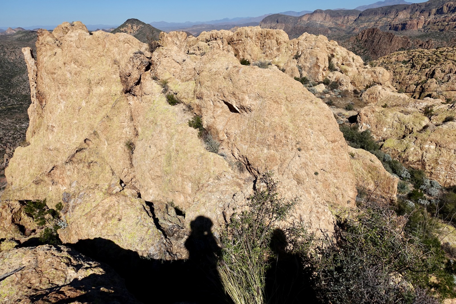
To reach the summit, finagle a way over or around the middle fin. This is a compact area and a bit of a conundrum. There was no trail and no cairns. We wove our way deliberately and carefully past the first obstacle, a Class 3 downclimb. We then went slightly to the south around the end of the middle fin, image-lower-right. There are other routes; find a way that's comfortable for you. Below, my shadow is at the top of the scramble. The bulk of the middle fin is before me and the east fin is across the flat.
We crossed the corridor between the fins and scrambled up easily from the south end of the east fin, Class 2+.

We passed through a trough and the crest is right there!

Balance on the summit of Palomino at 5.3 miles. The fin is three to four feet wide. It's very exposed but there are lots of features and the tuff is grippy. I'd have to think hard about it but that bubble of stone might be the tiniest zenith I've ever been on. Oh joy!

Below, I've walked about 20 feet north on the fin. This is the advisable turnaround. I love standing on arches but I wasn't overly tempted by this one. There are serious obstacles between here and the window. Plus, the span is too fragile to bear the weight of a human. (THW, photo)

We found an alternate route to the summit that is not as exposed from the west side of the fin. Watch out for crumbly, slick gravel throughout this area.

We played around looking for more arch views but didn't find anything that compared with the approach. First, we walked out the flat between east and middle fins as far as we dared. We did an exposed climb up the middle fin.

It offers the best view of the arch on the upper mountain (THW, photo)

We returned to Palomino Park and scampered up the west fin. (THW, photo)

From the lookout an array of peaks splay out in the north: Yellow Peak, Battleship Mountain, Geronimo Head, Four Peaks, and massive Malapais Mountain.

Back at the trail you have options: return as you came, climb Black Top Mesa, or return on the Black Mesa-Second Water Trails to complete the classic loop.