Essence: You could hike up Peak 13,325' from the town of Silverton; it's that close. The mountain forms the western wall of Boulder Gulch, a cascade-riddled gorge that plummets radically south, terminating at the Animas River. The climb begins on the Boulder Gulch Trail, steep but manageable for most hikers. However, the off-trail southeast ridge segment is recommended for experienced mountaineers due to steepness of slopes, a stretch of razorback ridge, and two gendarme workarounds with serious exposure. Mindful concentration is required--those who vanquish their fear will revel in this climb. Lists of John refers to the peak as East Storm but locals have called it Velocity Peak for decades. In April, 1982, Austrian Franz Weber broke the world's speed skiing record by rocketing down Velocity Peak at 126 mph on the final day of the International Speed Skiing Championships. The hike is on public land managed by the Bureau of Land Management.
Travel: Drive up Greene Street in Silverton
to the north end of town. Make a soft
right onto San Juan County Road 2. Drive 1.5 miles up the paved road and park in a large dirt lot on the right near placards for the Mayflower Mill Tailings Ponds.
Distance and Elevation Gain: 7 miles; 4,000 feet
Total Time: 5:00 to 6:30
Difficulty: Trail, off-trail; navigation moderate; Class 2+ with considerable exposure
Map: Silverton, Colorado 7.5' USGS Quad
Latest Date Hiked: August 24, 2022
Quote: Most of us are forgetting that from the beginning we are approaching death. Life is absurd…but you can fill it with ideas, enthusiasm. You can fill your life with joy. Reinhold Messner
Cliffs belt Velocity Peak on three sides. Access is by way of the southeast ridge, shown. This image was shot from the Storm Peak plateau. Tower Mountain forms the east wall of Boulder Gulch, image-right. (Thomas Holt Ward, photo)

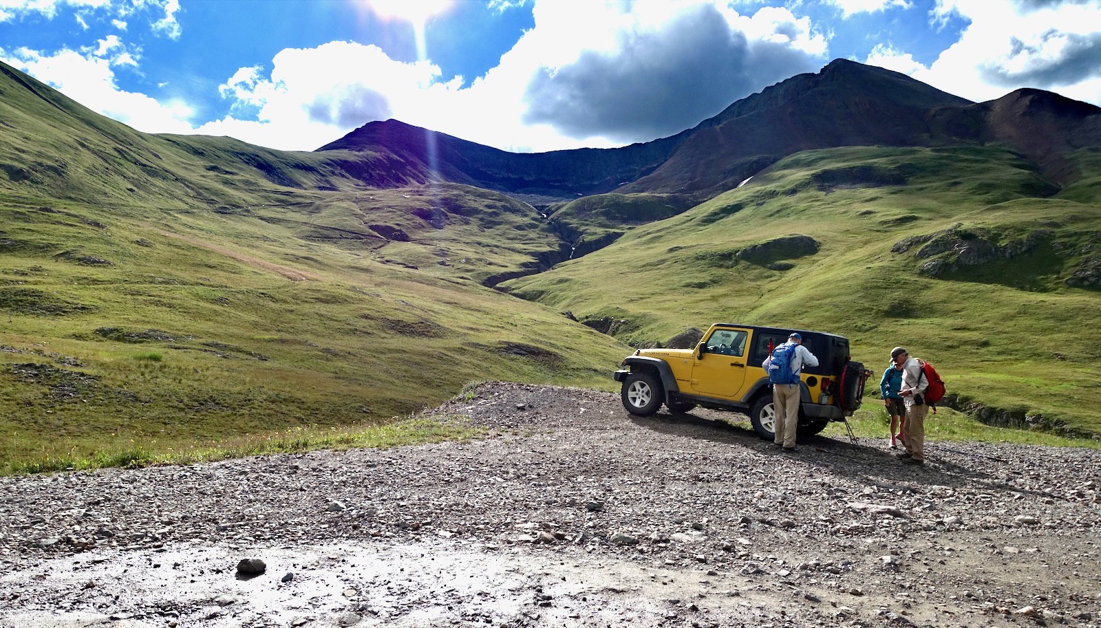
Route: From parking, walk north on the west side of the tailings and intersect a dirt road. Turn right and cross the Boulder Gulch trench. Hike north on the Boulder Gulch Trail. When the treadway crosses to the west side of the basin, pitch north off-trail to the peak. Return as you came.

The placards in the parking area, elevation 9,487 feet, pay tribute to the Mayflower Mill and Tailings Ponds. In
1870, the Little Giant gold vein was discovered high in Arrastra Gulch on the south side of the Animas River. This resulted in the first profitable hardrock mine in the
Silverton area. Extracted ore was sent via tram to the Mayflower Gold Mill located north of the Animas River on County Road 2. The mill operated from 1930 to 1991, the longest running mill in the
history of
the San Juan Mountains. The mill produced 1,940,100 ounces of gold;
30,000,000
ounces of silver; and 1,000,000 tons of combined base metals. In 2,000,
the mill was designated a National Historic Landmark. It is
owned by the San Juan County Historical Society and is open for
self-guided tours in the summer.
To get started, cross County Road 2 and walk up the track on the west side of the tailings. This road is gated and closed to vehicle traffic. 
Double-headed Sultan Mountain is the undisputed guardian of Silverton.

When the road turns to the right in a quarter mile, leave the track and walk a few paces straight ahead. Turn right on a secondary two-track. Watch for a cairn on your left
marking a faint social trail leading up to a more established dirt road
that runs to gulch from town. Turn right and walk to the creek crossing at 0.6 mile. When I climbed Velocity in 2010, we drove from Hillside Cemetery to road's end near the stream. In 2022, a locked gate barred motorized traffic. While you may walk to the Boulder Gulch Trail on this road, it'll cost you an extra mile.
The creek crossing was a tangled mess and the trail barely functional in 2006 when I first hiked up Boulder Gulch. In 2022, improvements were evident. There's a sturdy metal bridge strung across the creek and a wooden post marking the trailhead. The trail begins as steep as a staircase and then moderates slightly. It's been engineered with switchbacks and the platform was dug generously into the steep southwest slopes of Macomber Peak. Credit goes to the Silverton Singletrack Society. Their website features the Boulder Gulch Trail, a screaming mountain bike descent that drops 3,700 feet in less than four miles. The ride begins in Velocity Basin north of the divide. Cyclists are required to carry their bikes for 1,700 feet to Point 12,931' and the beginning of the trail. This brutal hike-a-bike may explain why we saw just one set of tracks. We enjoyed a day of complete solitude.

The path climbs steeply through the aspen forest. Soon the flickering ones reach their upper limit and the woods are shaded by spruce and fir. At 9,900 feet, cross an extensive blockfield generated from cliffs above. The trail platform has been smoothed by repositioning great quantities of rock, the Singletrack Society's noble effort to defy gravity.

At 10,300 feet, a thin thread of water barrels down an all-stone ravine. The walls on either side of the gulch are so severe and the canyon so declivitous, the gulch could just as well be called a gorge.

At 10,500 feet the forest resumes. The San Juans were hammered by daily monsoons in 2022 and the earthen floor was a mass of mushrooms. The treadway was smooth dirt, the grade moderated, and we could hear the watercourse coming up to meet us. Idyllic. At 10,800 feet the timber parted for good and the view opened in the narrow corridor. (THW, photo)

The distance walked was short but the gulch is lengthy. It felt like we were penetrating deep into the basin when actually we were far from the divide at its head. Summer flowers were waning by mid-August, leaving groves of harebells and bottle gentian--harbingers of fall. Tundra predominates in the rapturous basin and the southeast ridge of Velocity comes into view.

In 2006, I climbed Point 13,248', shown, with a friend in a vain attempt to summit Storm Peak from the south. From Point 13,248' we crossed the flat to Point 13,254' and descended to the saddle only to get turned back by an imposing 80-foot block. As consolation, we retraced steps and proceeded south on the ridge to Point 12,174'. We then made the ill-fated decision to pitch down the southeast ridge to the tailings ponds. We dropped to 10,400 feet only to be cliffed out. We clawed our way back up 400 feet and now committed and desperate, did a series of Class 5 downclimbs through cliff bands and chutes. It was "nasty and intense." (THW, photo)

This image looks down the plunge toward the Animas River. (THW, photo)

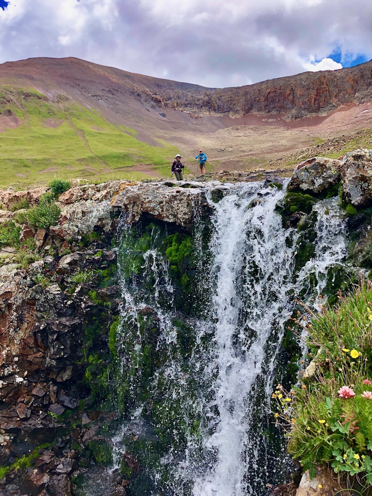
Still on-trail, cross to the west side of the gulch at 2.2 miles, 11,440 feet. The trail used to effectively disappear in the tundra but now it continues to the divide. Someday I will follow it to the top of the basin and climb the northwest ridge of Tower Mountain. (Please link to August, 2023 post.) For those going on to Velocity, it is 1.1 miles up the southeast ridge (image-left) with almost 1,900 feet of vertical. Whew.

Going up, we stayed on the trail for one big switchback, postponing the punishment for 0.2 mile. It was rewarding to see the cascades draining glacially carved lakes sitting in the cirque southeast of Storm Peak, the sentimental master mountain in this compact area. (THW, photo)

The bees gravitated to golden asters blooming beside the trail. (THW, photo)

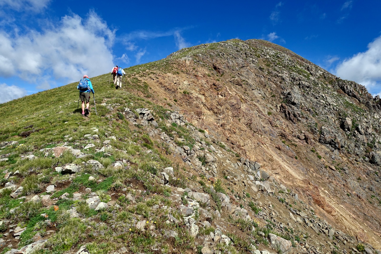
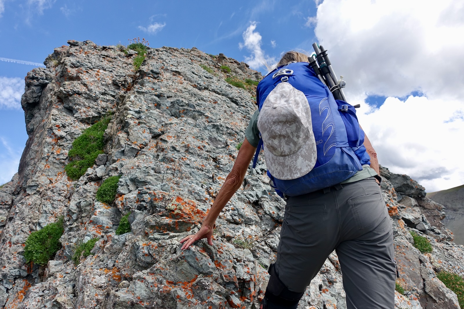
We launched off-trail from the very center of the ridge. It was flowers-in-your-face steep. There was some chipped rock rolling underfoot but the plant platforms were helpful. There are two cruxes on this climb. We could see the first one, the "Throne," from the grassy slope well below.

These climbers are hefting up the slope to the lower crux at 12,660 feet. (THW, photo)

Approach the Throne on a gray ridgelet of stone. I first climbed Velocity with a hiking club from Durango. The Throne was intimidating enough to turn back a few people.

Decide for yourself how you want to attack this beast. On both of my visits, at the base of the wall we crept a few yards to the right, hooked left, and pitched up an opening to the centerline. Then we climbed straight up the bulb of rock. The initial short traverse is severely exposed and the footing is troubled with rubble. I used the wall to steady myself but don't expect the friable volcanic rock to remain attached.

Spider up the bulb. It's a short pitch that requires laser focus. Holds are tiny but they offer friction.
This image looks down on the Throne. (THW, photo)

A false summit lies just up the ridge, image-right. This photo illustrates the seemingly impossible traverse between Velocity and Storm Peak. (THW, photo)

Go right over the top of the false summit at 12,960 feet.

Velocity Peak shows itself, finally. The ridge is open and friendly as climbers approach the upper crux. (THW, photo)

Confront the upper crux at 3.3 miles, 13,100 feet. The image below was taken on our return and depicts the challenge well. Both times we worked around the gendarme on the east side (below, left of the plug). Walk for about 80 feet on a slanting platform at the base of the wall. There's no scrambling but the footbed is rubbly. The slope to the east is effectively vertical for 500 feet so this is a no-slip zone. The placement of every footfall matters. In 2010, our group splintered once again here. However, my amygdala-compromised friends don't even recall this crux. (THW, photo)

The upper mountain is relatively straightforward. We worked our way up and over the next outcrop on its left.
(THW, photo)

The ridge thins for a sustained stretch. It is three feet wide in places. The only difficulty is the integrity of unseated rock. (THW, photo)

Arrive on the two small summit domes of Velocity at 3.5 miles. There's no peak register, alas, and no alternative exit from this tiny crest. Storm Peak is a stone's throw to the west, neighbors, yet impossibly far apart. There is a perilous route to the summit of Storm via the west ridge. Click on the link for another Reinhold Messner quote, a synchronistic, unplanned occurrence!

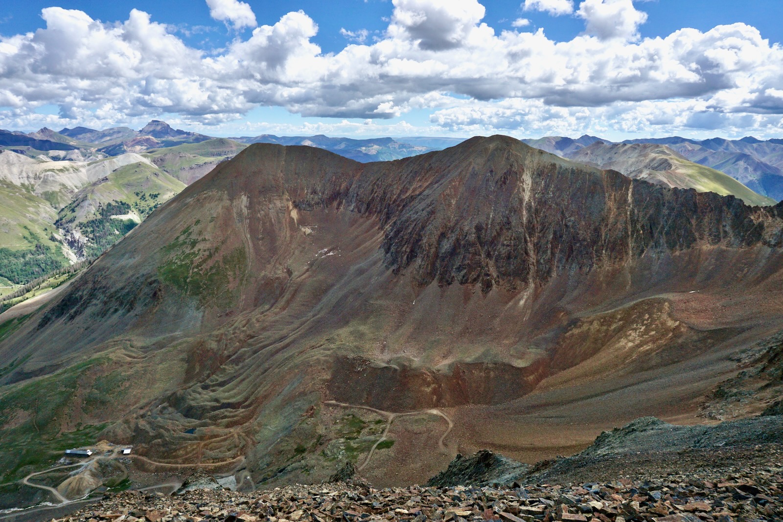
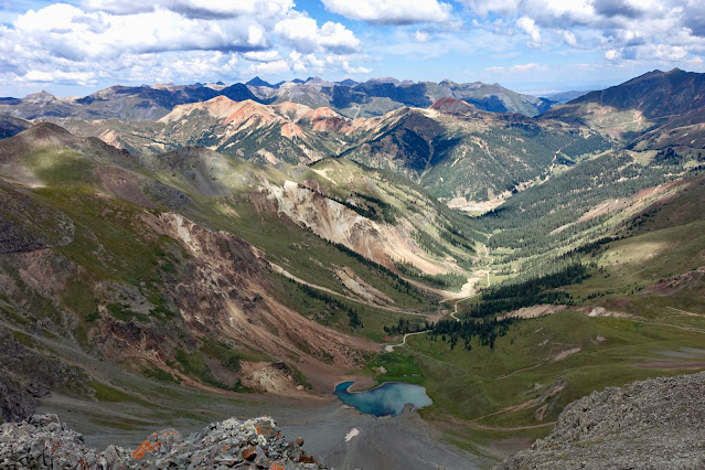
North of the divide is Velocity Basin, the Reds, and the Sneffels group. Follow along the north ridge of Storm for a glimpse of the Silverton Mountain ski lift (off-image). Velocity Basin is a popular backcountry ski destination for locals.

North and east is nearby Proposal Peak (image-left), Uncompahgre Peak, Handies Peak, Jones Mountain and Niagara Peak, and Tower Mountain, directly across Boulder Gulch. Of note: Some friends climbed Velocity from the vicinity of the northeast ridge. It was steep and loose, the holds were poor, and it was exceedingly unpleasant. But it can be done.

Below, the savagely ragged Grenadier Range and Needle Mountains in the Weminuche Wilderness just make it above Silverton's impressive peaks and high basins contributing to the headwaters of the Animas River. Altogether, Velocity Peak provides a comprehensive view of the never-ending mountaintops in the Southern San Juans. (THW, photo)

The final two images afford differing perspectives on Velocity Peak. The first was shot in the autumn of 2016 from Storm Peak looking east to Velocity, image-right.

This photo was shot in 2013 from the north ridge of Tower Mountain. Storm is image-center. A substantial escarpment complicates the northeast ridge of Velocity Peak.