Sunday, March 27, 2022

Diaz Spire, 3,892', Organ Pipe Cactus National Monument

Essence: Diaz Spire is among the compact triumvirate in the southern sector of the Ajo Range. Compared with the other peaks on the pinnacle-encrusted massif, the Spire looks the most intimidating but it is arguably the easiest to climb. Slopes are rather steep and footing is rough but there are no obstacles standing in the way of those who wish to claim this powerful monolith seen from places both high and low throughout the Monument. Visitation is rare. There are no guiding footprints or cairns and navigation is a serious challenge. The hike is within the Monument, administered by the National Park Service.
Travel: From the Visitor Center, cross AZ 85 and measure distance from the beginning of the 21-mile, one-way Ajo Mountain Drive. Pass the Estes Canyon Picnic Area and Trailhead. Park on the left off the main road at a closed track at about 12.7 miles. The Ajo Mountain Drive guide lists this as Stop #14. 
Fees and Camping: Consult the Monument website; entrance fees and the camping reservation system have changed repeatedly over the years.
Distance and Elevation Gain: 8.6 miles; 1,900 feet of climbing
Total Time: 5:30 to 7:30 
Difficulty: Two-track, off-trail; navigation challenging; Class 2+; no exposure; dress defensively. Hike on a cool day and carry all the water you will need.
Map: Diaz Peak, Arizona 7.5' USGS Quad
Date Hiked: March 27, 2022 
Personal Note: I've been hanging out and hiking in the Monument for three decades. On the eve of my 2022 birthday, my partner and I hatched a plan to climb Diaz Spire which struck us as being appropriately ultra cool. We didn't have the Diaz Peak quad and knew nothing about the route. Internet was poor in the campground but we managed to download a track. Inevitably this strategy (not good wilderness practice!) meant we were entering a mysterious world where our route questions were answered on the fly.
Quote: We don’t stop hiking because we grow old—we grow old because we stop hiking. Finis Mitchell
 
Flaming ocotillo torches mimic the evanescent flare of Diaz Spire as the sun settles down over the Twin Peaks Campground. (Thomas Holt Ward, photo) 
 
Route: From Stop #14 on Ajo Mountain Drive, hike southeast on an old road to a T intersection and then bear east. At two miles leave the track and cross a ravine bearing east-southeast on the south side of Point 2,358', staying north of a small ridge capped with brilliant white stones. At 2,400 feet start up a broad ridge that arcs south to the saddle between Diaz Peak and Spire. Ascend west, flanking a major gendarme on its south. Return as you came. Note: The Diaz Peak quad has 20 foot contour intervals.
 
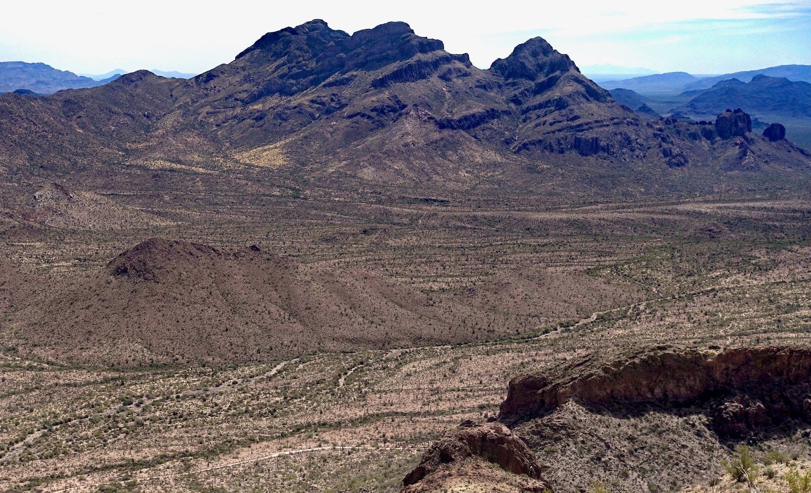
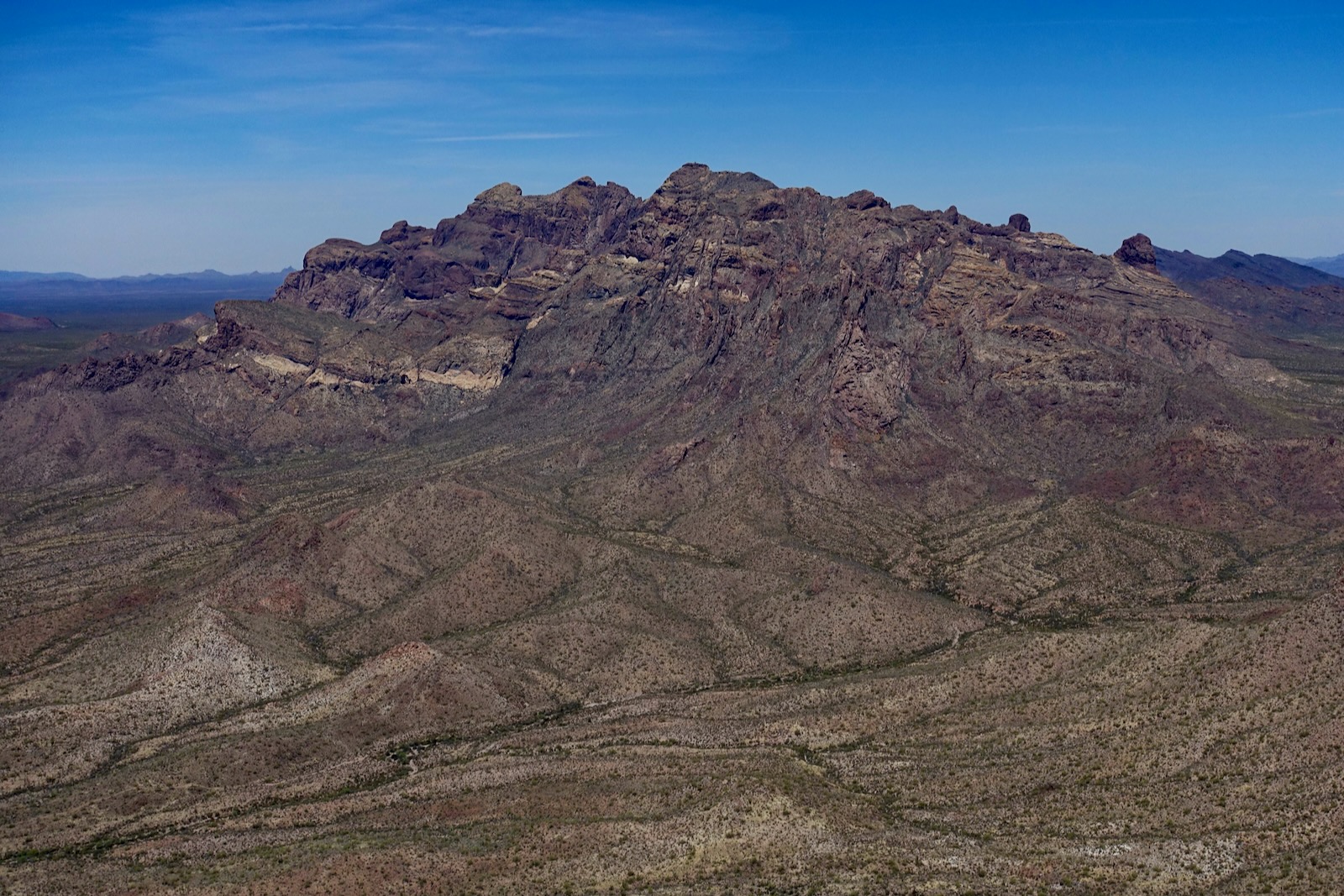
The orientation image below was taken from the highpoint of the Diablo Mountains the day prior. Diaz Peak, 4,024', is on the left with 1,501 feet of prominence. Diaz Spire is to its right with 362 feet of rise, followed by Peak 3,704' with 434 feet of lift. We erroneously assumed that we'd be hiking to the obvious Spire-Peak 3,704' saddle. Instead, the hike passes the low-slung hills in the foreground on the south/right and heads to the low ridge in the valley north/left of the peaks. It makes for Saddle 3,530' (unseen in this snap) between Diaz Peak and Diaz Spire. 

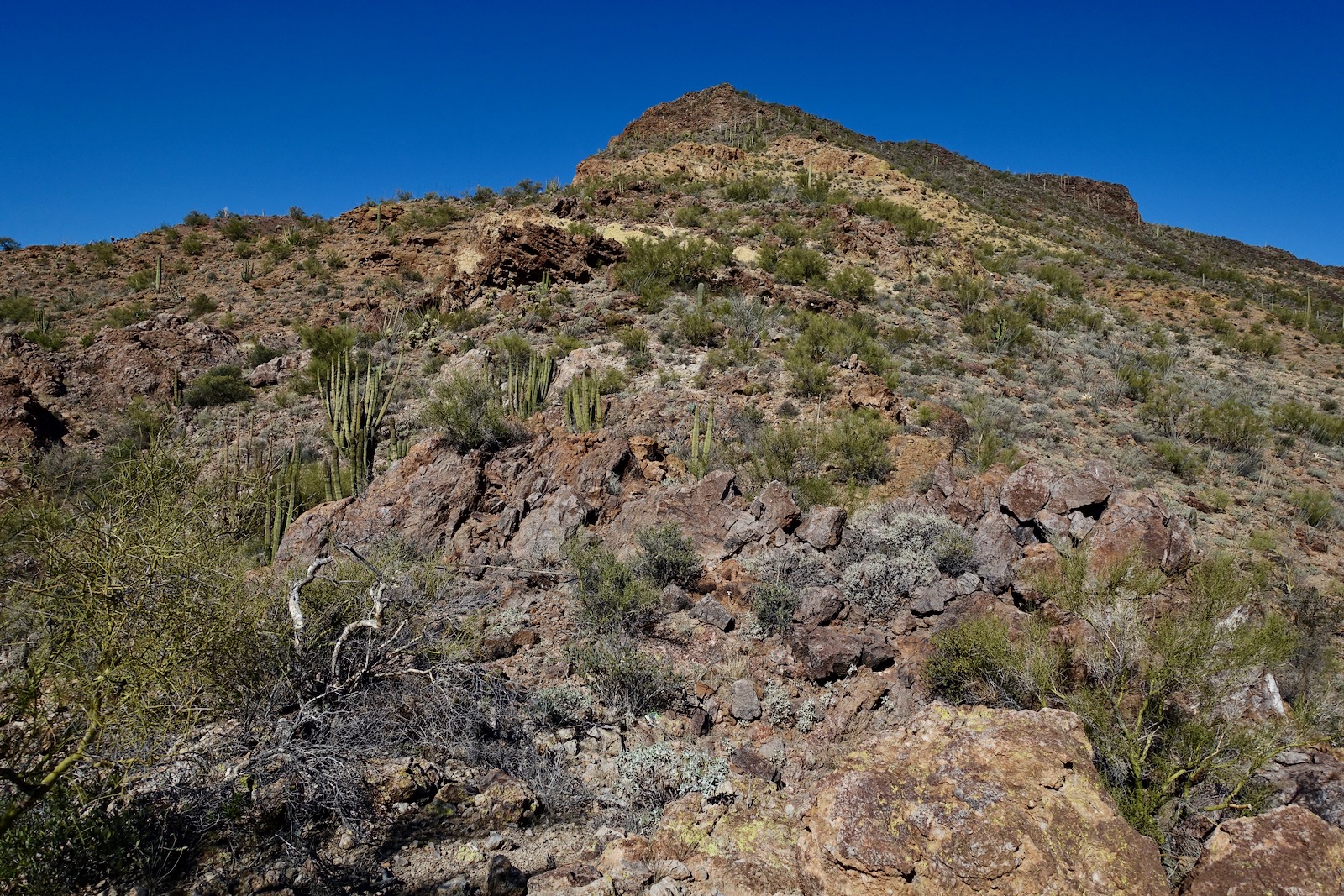
From the parking pullout at elevation 2,150 feet, walk south on the road closed to vehicles. We surmised that the recent OHV tracks were associated with the Border Patrol. Plants were climax Sonoran: mature organ pipe cactus with multiple trunks, thick-stalked ocotillo, cane and chain fruit cholla, palo verde clusters, saguaro, jojoba, and creosote. The road drops into and out of a series of shallow and deep washes. Sure, you could wander around in the open desert but the road is simple, quick, and a navigational aid. Stay with it as it threads between Point 2,317' and Point 2,298'. It then tracks south of a small hill, 2,199'.
 
The road reaches a T intersection at 1.7 miles. Turn east/left and soon come alongside a trenched arroyo that carries water shed from the prominences in the vicinity of Sweetwater Pass. Leave the road and cross the drainage at a suitably shallow place at about 2.0 miles, shown. After no appreciable elevation gain, the ascent begins. Hike south-southeast, passing between another set of small hills, staying south of Point 2,358' and north of a tangled wash draining the basin north of the peaks.
 
The next landscape marker is a white-capped ridge, elevation 2,590 feet, image center-left. Pass northeast of it while making for the low ridge in the center of the basin. This is rough country--brushy with large rocks underfoot.
 

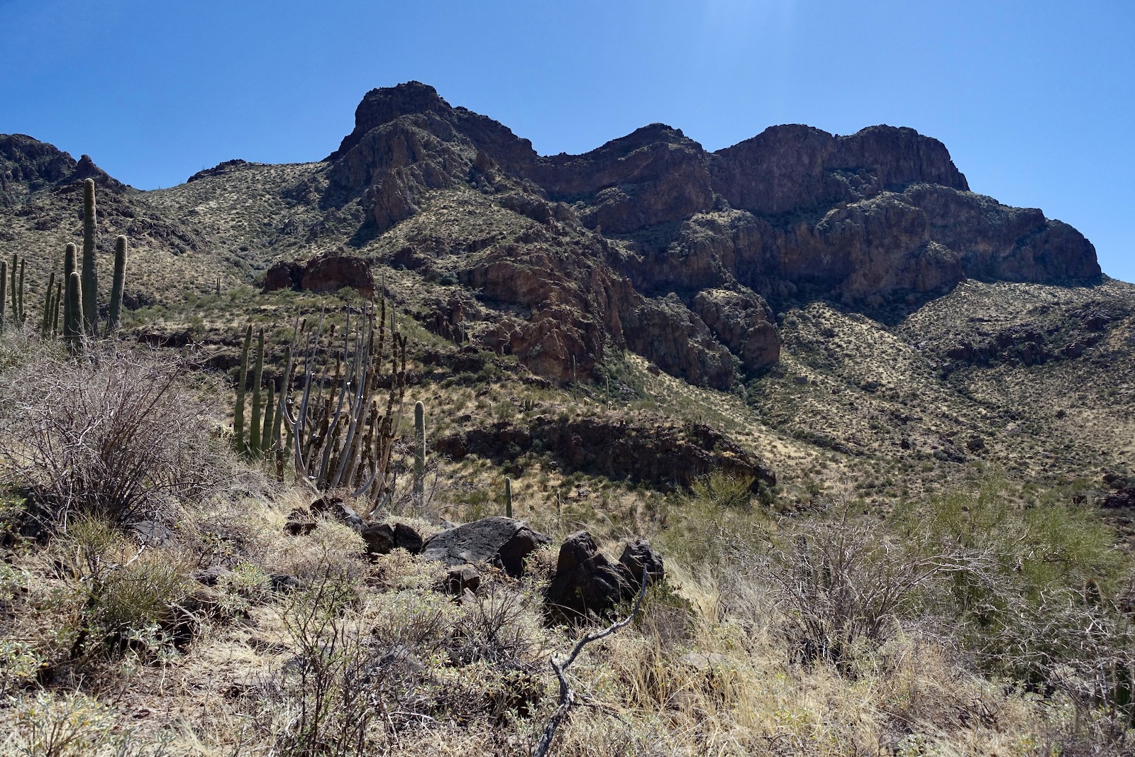
Start up the ridge at about 2,400 feet and stay on it as it arcs from southeast to south making for the saddle.
 
At last, the elusive Diaz Peak-Spire saddle comes into view, image-left. On the right is the east ridge of Diaz Spire beginning with the gendarme, two false summits, and the peak.
 
An outcrop straddles the ridge at 3,200 feet. Enjoy the Class 2+ scramble or flank the formation on the east.
 
The slope between the outcrop and saddle is steep and rubbly. (THW, photo)
 
Arrive on the saddle at 3.8 miles, 3,530 feet. Although there were no signs of recent passage this was clearly a migration pathway because the saddle was covered with empty black water bottles and assorted trash. It was a little disconcerting for we had heard tales of a hiker stumbling on smugglers on nearby Peak 3,704'. Diaz Spire is just a half mile west. But first, we were curious whether we could zip on up Diaz Peak.
 
We climbed just 100 feet before confronting a crux. This was going to be a project. We deeply wanted to climb the Spire and the day was in the 90s. So we left the peak for another day.
 
This image was shot as we returned to the saddle. We bypassed the initial outcrop on the north. Next, the sizeable, no-nonsence gendarme must be dealt with. The only through route is on its south/left side. However, we didn't know that and we tried the north side first. (THW, photo)
 
We were soon cliffed out on a thin precipice hanging out over a sweeping, vertical-walled amphitheater. We backed out, glad that we checked out this silent, private world. (THW, photo)
 
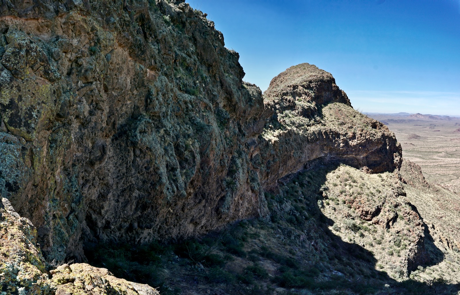
The slope on the south side of the resistant volcanic plug falls off steeply and some material is loose. Take your time.
 
The greatest hazard is teddybear cholla. Rock formations on the monolith are fascinating and vary widely from pebble breccia to welded tuff and silky smooth rhyolite. 
 
Return to the ridge to conclude with a pleasant climb over a couple of knobs capped with basalt boulders.
 
Drawing close, Diaz Spire is surprisingly welcoming. Arrive on the relatively broad pile of boulders at 4.3 miles. 
(THW, photo)
 
The peak register was placed in 1998 on a scrap of paper. Gerry and Jennifer Roach of Colorado guidebook fame left a formal sheet in 2006. Eight years passed until the register was signed again. I can only speculate that the Spire lives in the shadow of Diaz Peak, the highpoint of the Diaz threesome. Diaz Peak and Spire are named for Captain Melchior Diaz, Spanish conquistador and member of the Coronado Expedition 1539-1542.

This image looks back to Diaz Peak. The lands east of the peak are within the Tohono O'Odham Nation. (THW, photo)
 
I first climbed Mount Ajo in March of 2005 during a superbloom. I specifically recall looking over to Diaz Spire and figuring it was outside the realm of possibility. The most challenging mountains we have climbed in the range thus far are Peak 4,740' and its companion Point 4,700', seen below to the left of Mount Ajo. 

In contrast, Tillotson Peak, seen here rising from the Valley of the Ajo, is a playful, half-day hike for people who love to mess around on boulders.

Even if you walk west until the arc starts to fall off into oblivion, you can't see down into the Spire-Peak 3,704' saddle. It is pure air (as a good spire should be) on all sides save the one that transported us to this wondrous and neglected sentinel.

Saturday, March 26, 2022

Peak 3,372', and Point 2,900', Diablo Mountains, Organ Pipe Cactus National Monument

Essence: Ajo Mountain Drive encircles the Diablo Mountains. Two northwest-bearing ridges fan from the highpoint of the small range, Peak 3,372'. This delightful, half-day hike climbs the neglected summit for uncommon views of the Ajo Range close by in the east. On a whim, we ventured out the more northerly ridge to its end on unranked Point 2,900'. This was somewhat spicy, increasing the level of difficulty. There were obstacles to dodge but all the puzzles were solved easily enough. Both segments of the hike have compelling features created by volcanism. This hike is recommended for people experienced with navigating off-trail in the desert. It is more taxing than the statistics imply. The hike is within the Monument administered by the National Park Service.
Travel: From the Visitor Center, cross AZ 85 and measure distance from the beginning of Ajo Mountain Drive. Pass the mouth of Canyon Diablo and Arch Canyon trailhead parking. Pull out and park on the right at 10.1 miles. The Ajo Mountain Drive guide lists this as Stop #11, 10.4 miles.
Fees and Camping: Consult the Monument website; entrance fees and the camping reservation system have changed repeatedly over the years. 
Distance and Elevation Gain: Peak 3,372' is 3.0 miles with 1,200 feet of climbing, round trip. Point 2,900' adds 1.2 miles and 300 feet.
Total Time: 2:30 to 3:30 for Peak 3,372'; add 1:00 to 1:30 for Point 2,900'
Difficulty: off-trail; navigation moderate; Class 2+ with no exposure; steep slopes. Hike on a cool day and carry all the water you will need.
Map: Mount Ajo, AZ 7.5' USGS Quad
Date Hiked: March 26, 2022
Quote: I am in love with this world...I have climbed its mountains, roamed its forests, crossed its deserts, felt the sting of its frosts, the oppression of its heats, the drench of its rains, the fury of its winds, and always have beauty and joy waited upon my goings and comings. John Burroughs

For travelers on Ajo Mountain Drive, the disordered front wall of the Ajo Range understandably consumes attention. In contrast, the highpoint of the Diablo Mountains seems perfectly ordinary and generally goes unnoticed. And yet, it holds treasures awaiting discovery. The image below was shot from Point 2,900' looking south to Peak 3,372'.
 
Route: From parking on Ajo Mountain Drive, hike generally south to Point 3,020'. Follow the north ridge of Peak 3,372' to the summit. Return as you came. For those going to Point 2,900', return to Point 3,020', turn northwest and follow the ridge over Point 2,930', bypassing a couple of obstacles. To return, retrace your steps 0.2 mile, leave the ridge and cut northeast across the desert back to your vehicle.

There are no cairns on this hike. You must be comfortable using landscape markers as your guide. This image was shot from the parking pullout at elevation 2,500 feet. It looks south to Point 3,020' and a small hill that's hard to distinguish in the foreground. The top of the hill is your first objective.

In 2022, the American West was suffering under a megadrought and wildflowers were scarce. We did see the hearty creosote bush in bloom, a few desert chicory, fairy duster, brittlebush, and a new one on us, American threefold. 
(Thomas Holt Ward, photo)
 
Roll over the little hill at a quarter mile, 2,640 feet. The view opens to the climb ahead and to dazzling peaks in the southern sector of the Ajo Range: Diaz Peak, Diaz Spire, and Peak 3,704'.
 
Give up 50 feet to bridge over to the north ridge of Point 3,020'. The Sonoran flora was particularly lush here with dense organ pipe cactus, palo verde, varieties of cholla, jojoba, fishhook barrel, saguaro, and magnificent hedgehogs. The view was already incomparable. Look down on Estes Canyon and the trailhead for Bull Pasture and Mount Ajo. Packed tightly together but separated by an impassible gap is the Point 4,700' and Peak 4,740' duo and Mount Ajo, 4,808'.
 
Ascend on sheets of tuff with resurrection moss thriving on bits of soil, filling in crevices, and holding rock in place. Together, stone and moss create the ultimate experience in pleasant hiking. The iridescent lime-yellow lichen is a complex life form that is a symbiotic partnership of two separate organisms, fungus and alga.
 
Approach a beautiful wall composed of welded tuff, a product of an explosive volcanic eruption. It was so hot at the time of deposition, volcanic ash and small rock fragments were welded together forming pyroclastic rock. Flank the wall on the right. 

Climb through fallen boulders, pitching steeply back to the ridgetop at first opportunity.

Crest Point 3,020' at 0.8 mile. This is the pivot location for those going on to Point 2,900' later in the hike. The highpoint is revealed and so is the challenge it presents, primarily a high-angle slope. First, give up 80 feet traversing to the base of "Yellow Hill." (THW, photo)

A 12-foot-high wall straddles the ridgeline. My partner climbed it easily while I poked around and found a quick bypass on the east. 
 
Going up and over Yellow Hill is one of the best features of the hike. The tuff comes at you in multiple stacked sheets like a layer cake with oozing frosting. The ascent is gradual and passes by a series of caves. (THW, photo)

Stand on the tuff dome at 1.2 miles, 3,040 feet. If you are tapped or running short on time, Yellow Hill is a worthy destination. We had no trip reports for the Diablo Mountains so this entire hike was a mystery that unraveled as we walked. From the hilltop we formed a plan for the climb. We went to the right of the apricot-colored tuff wall and worked our way up past a big cave. The incline was quite steep but there were no major obstacles. Most of the material was well seated but not all. It pitches more radically near the summit with plates of rhyolite talus on the upper cone.

This image looks down on the slope and the absolute perfection of Yellow Hill. (THW, photo)
 
Mount the zenith of the Diablo Mountains at 1.5 miles. The summit is broad, the apex of the horseshoe-shaped ridgeline above Canyon Diablo. Point 3,080' marks the end of the ridge on the south side of the chasm and Point 2,900' is the terminus of the more northerly ridge. Pinkley Peak, shown, is due west in the Puerto Blanco Mountains. Sierra Cubab in Sonora, Mexico rises mightily above the border town of Sonoyta. The peak register was placed in 2001 with one yearly entry on average since then. Peak 3,372' is literally and metaphorically in the shadow of the Ajo Range.

As indicated in the register Canyon Diablo is an appealing alternative route to the summit. Tillotson Peak is the colorful, isolated mountain to the northwest. It could be combined with Peak 3,372' in one day from different trailheads. From this vantage point we decided to explore out the ridge toward Point 2,900'.
 
The descent from Peak 3,372' looks like a precipice at the top. Use caution and intention to keep the plates stable.
  
Return to Point 3,020' at 2.3 miles. If you have had enough, retrace your steps to your vehicle. It is one mile from here to the end of the ridge and takes about an hour. From the pivot point we could see strong obstacles out in front and figured we'd have to be charmed to make the entire passage. 

We walked through an ocotillo forest and crossed a bridgeway made of tuff. The first obstacle was a bulbous, billowing blob of welded tuff at 2.6 miles. We did a work-around on the southwest which enveloped us in a world of welded stone. It appears that you could also bypass on the right but we did not try that.

We returned to the ridge and walked across a red flat that was a magical synergistic community of plant and stone. Below, Point 2,930' is just ahead, image-center. However, first we had to negotiate a 60-foot drop at the end of the flat. We bypassed south which required a four-foot drop but there may be other options.
 
From Point 2,930', the landscape was so irresistible and we were having so much fun we continued onward. We walked over the top of a cone composed of rhyolite plates (image-center), yet another premier feature on this enthralling adventure.
 
To reach the end cap, you may either go through the gap on the north or climb straight up the ridgeline.

Elation! Point 2,900' (3.3 miles) is a tiny pinnacle with big drama. We could have been stopped by any number of obstacles but the ridge gave us a pass. The airy outpost was void of even a summit cairn. Please see the feature photo at the top of this post for a look down into Canyon Diablo and across raw space to Point 3,080'. (THW, photo)

To return, we down-climbed the summit block and retraced our steps while looking for a good exit downslope.
 
We reclimbed the dome of slabs and then left the ridge 0.2 mile from the outpost. We could see our vehicle from the ridgetop and used dead reckoning to stay on course. To do that, we found a spot in the Ajo Range (Point 4,700') that corresponded with our vehicle's location and aimed for that. Ridge to parking was only 0.7 mile and took 20 minutes. The upper slope was rubbly but we avoided all the cliffs. The route was good but surely there are other options.
 
If you are a peak-bagger, climb the highpoint and call it good. Wander on out to Point 2,900' to prolong your communion with Nature, revel in beauty, and have the pleasure of solving navigation puzzles.
 
Point 2,900', Peak 3,372' above the mouth of Canyon Diablo, and Point 3,080' are seen together at just the right vantage point along Ajo Mountain Drive.

Thursday, March 24, 2022

Tillotson Peak, 3,374', Organ Pipe Cactus National Monument

Essence: Having climbed many peaks taller and tougher in the Monument over three decades, Tillotson finally had its day. What a discovery! The peak is in the very center of the Organ Pipe Cactus world. It was born from fire and is clothed in the colors, and made of rocks, only volcanoes can create. The mountain has a boulder-capped linear summit ridge. This playful, half-day hike is for scramblers who are experienced with off-trail desert exploration. The hike is within Organ Pipe Cactus National Monument administered by the National Park Service.
Travel: From the Visitor Center, cross AZ 85 and measure distance from the beginning of Ajo Mountain Drive. Pass the Diablo Canyon picnic area. When you see the east slopes of Tillotson, you are getting close to the start of the hike. The road descends a few feet into a small drainage, goes up the other side, and makes a 90 degree swing to the right. There is room for just one vehicle in the pullout on the left, 7.6 miles from the beginning of the loop road. Please respect the restoration area by parking in the one designated spot. 
Fees and Camping: Consult the Monument website; entrance fees and the camping reservation system have changed repeatedly over the years. 
Distance and Elevation Gain: 4 miles; 1,050 feet
Total Time: 3:00 to 4:00
Difficulty: Jeep track, unmaintained trail, off-trail; navigation moderate; Class 2+ scrambling; mild exposure. Hike on a cool day and carry all the water you will need.
Maps: Mount Ajo; Tillotson Peak, AZ 7.5' USGS Quads
Date Hiked: March 24, 2022
History: The peak is named for Minor Raymond Tillotson. He worked for the National Park Service from 1920 to 1955. He was regional director of southwestern parks, including Organ Pipe Cactus, in 1940.
Quote: It is an honor to walk where all around me stands an earth house made of scarlet, of jet, of ochre, of white shell. It is more than beautiful at the center of the world. Joy Harjo
 
Tillotson Peak rises from the Valley of the Ajo as seen from Peak 3,372', the highpoint of the Diablo Mountains.

Route: From the pullout on Ajo Mountain Drive, hike southwest on an abandoned road. Segue to the east ridge and stay on the ridgecrest as it swings northwest and finally north to the summit. Or, as indicated on the map, stay on the trail to a saddle at 2,740 feet and ascend north off-trail to the east ridge. Note: the Mount Ajo topo has 40 foot contour intervals. Intervals on the Tillotson Peak quad are 20 feet.

From the small pullout at 2,420 feet, we walked southwest across the open desert. We dropped into and back out of a small drainage and then unexpectedly happened upon a helpful two-track at 0.2 mile. On our return, we followed the track back to Ajo Mountain Drive as shown on the map above. If you'd like to begin on the old road, walk back on the incoming road for 0.1 mile and you will see it bearing west. The Sonoran takes over immediately with organ pipe cactus, chain fruit and staghorn cholla, pricklypear, ocotillo, saguaro, jajoba, palo verde, and the eternal creosote bush. Wildflowers were sparse in 2022 and we longed for the superblooms we'd seen on occasion at the Monument. Below, I'm walking toward Tillotson and the climbing ridge is on or near the horizon left of the summit. (Thomas Holt Ward, photo)
 
Walk past a forest of organ pipe cactus packed in tightly on the southwest side of a small knoll. The road swings to the northwest and grows faint. Use your intuition to stay the course on the old treadway. At 1.1 miles, another track joins from the right. As you can see on the map, we blew right by this junction on our return so make a mental note or set a cairn so you are sure to retrace your steps. The image below shows the dwindling road and the exciting route to the summit.
 
At 1.2 miles, 2,540 feet, we left the trail and crossed a shallow ravine to access the east ridge. This turned out to be a delightful route (not too brushy, not too steep) and ridge purists will want to make the move. But, as we discovered on our return, you could stay on the trail to a saddle and then hike off-trail up to the ridge. That option is described later in this post.

Step off the trail and the natural habitat of Tillotson is both beautiful and entertaining. Pinkflower hedgehog clusters were exceptionally large and covered in buds about to burst into bloom. The ridge offered no resistance, just a set of Class 2 rocks to the first knob at 1.4 miles, 2,760 feet.

From the knob you can see the climb ahead and the layering of volcanic material. The Monument is contained within an ancient volcanic field that covers 1,900 square miles. Brilliantly-colored tuff bands interweave with basaltic andesites found on the higher slopes of the mountain. 

Maneuver through a complicated band of tuff, an igneous rock that forms from the products of an explosive volcanic eruption. To be classified as tuff, the rock must contain more than 75% ash. The largest and most plentiful assortment of tuff caves we've found are on Pinkley Peak. The lime-yellow lichen is a complex life form that is a symbiotic partnership of two separate organisms, fungus and alga. Our favorite samples in the Monument are on Mount Ajo.
 
I've passed through a lot of ash flow tuff and always look forward to it. It is fascinating, gorgeous, grippy, and generally free of brush. (THW, photo)
 
Transition from tuff to a basalt boulder staircase that transports you to a prominent knob, shown. The community of cactus is rich but they are easy to dodge. We found a lot of scat here but could not distinguish between deer and bighorn sheep. (THW, photo)

Top the stony knob at 1.7 miles, 3,240 feet, and pivot north on the summit ridge. (THW, photo)
 
The ridge is a big boulder affair. The rocks are large, nonsensical, jumbled, and balanced precariously on each other. How did they come to rest in these remarkable positions? Were they blown out of a volcano? The ridge is narrow but never scary; it doesn't drop radically on either side. (THW, photo)

It's about 0.2 mile along the summit ridge in variable terrain.
 
This false summit is great sport for people who like to get their hands on boulders.

Crest the linear summit platform at 1.9 miles. You will feel like you are on top of the Sonoran Desert and at the very center of the Monument. The peak register recorded only one to two entries a year since it was placed in 2016.
 
Continue north on the ridge for a better sense of Tillotson's 994 feet of prominence. Peak 2,968' is in the next isolated two-peak cluster.

Tillotson garners an uncommon perspective on the Ajo Range to the east. If you are inspired to climb one or more peaks, in order of increasing difficulty they are: Mount Ajo (center-right); Peak 4,158' (image-left); Peak 4,540' (right of Peak 4,158'); and Peak 4,740' and Point 4,700' (left of Mount Ajo).

Southwest are the Twin Peaks (Gadsden and Levy peaks) at park headquarters. Five miles south on AZ 85 is the US-Mexico border in Lukeville. Across the line is the city of Sonoyta and the tantalizing Sierra Cubab range. 
 
Pinkley Peak with the aforementioned caves is in the Puerto Blanco Mountains to the west.

On our return we spotted a trail coming up to the small saddle (image-center, left of tuff band). Out of curiosity we checked it out. Descend through the somewhat loose basalt-andesite material, shown. (THW, photo)

Play around on the tuff band. (THW, photo)

Once in the saddle at 2.4 miles, 2,740 feet, it is rather difficult to find the trail so peg it before you arrive. There was a fair amount of trash in this area and we wondered if this was a migrant trail. The footpath took us back to our upcoming route. We ran the road out to Ajo Mountain Drive at 3.9 miles and turned left to return to our vehicle.

Below, Tillotson Peak displays its south face to travelers on Ajo Mountain Drive.