Essence: The Rico Mountains are a small range separated into two blocks by the Dolores River and the historic mining hamlet of Rico on CO 145. There are seven ranked peaks on the west block and five on the east. Whitecap lies one mile southwest of Blackhawk Mountain, the high point in the range. The long, 4.2 mile approach on the Colorado Trail begins from Hotel Draw in the Hermosa Creek drainage. The woods retreat in the crystalline, high alpine Straight Creek basin. Leave the cross-state trail at "Blackhawk Pass" and the excitement begins. The half-mile-long north ridge of Whitecap is an exercise in mindfulness for experienced mountaineers. It is exposed and the rock is shattered and loose. The near vertical crux on the summit cone argues for limiting group size to two. The flat-topped, relatively spacious summit is another of Colorado's remarkable points of vantage. LiDAR, a new, more accurate measurement technology, has elevated Whitecap to 12,409 feet with a prominence of 365 feet. The hike is within the San Juan National Forest.
Travel: In a 4WD, high clearance vehicle turn west from US 550 into Purgatory Resort and measure mileage from there. Drive up the winding road and turn right on FSR 576 near the upper parking lots at a small brown building (0.4 mile). Turn right at 3.2 miles toward the Hermosa Creek Trail. At 8.7 miles the spur to popular mountain bike trails branches left. Stay on the main road following a sign for Hotel Draw and Bolam Pass. The road deteriorates. Ford Hermosa Creek at a shallow, distributed, and flat crossing at 10.2 miles. Avoid in high water. At 11.2 miles turn left on FSR 550 (unsigned) toward Hotel Draw. The dirt road narrows and is prone to developing deep ruts. There is a small pullout and sign for the Colorado Trail at 15.0 miles, Benchmark 10,419'. Allow 45 minutes to one hour from Purgatory.
Travel: In a 4WD, high clearance vehicle turn west from US 550 into Purgatory Resort and measure mileage from there. Drive up the winding road and turn right on FSR 576 near the upper parking lots at a small brown building (0.4 mile). Turn right at 3.2 miles toward the Hermosa Creek Trail. At 8.7 miles the spur to popular mountain bike trails branches left. Stay on the main road following a sign for Hotel Draw and Bolam Pass. The road deteriorates. Ford Hermosa Creek at a shallow, distributed, and flat crossing at 10.2 miles. Avoid in high water. At 11.2 miles turn left on FSR 550 (unsigned) toward Hotel Draw. The dirt road narrows and is prone to developing deep ruts. There is a small pullout and sign for the Colorado Trail at 15.0 miles, Benchmark 10,419'. Allow 45 minutes to one hour from Purgatory.
Distance and Elevation Gain: 11.1 miles; 2,900 feet
Total Time: 6:00 to 8:00
Difficulty: 8.8 miles trail, 2.3 miles off-trail; navigation moderate; Class 3 with considerable sustained exposure with unreliable holds; two, 50-foot near vertical walls
Total Time: 6:00 to 8:00
Difficulty: 8.8 miles trail, 2.3 miles off-trail; navigation moderate; Class 3 with considerable sustained exposure with unreliable holds; two, 50-foot near vertical walls
Map: Hermosa Peak, Colorado 7.5' USGS Quad
Date Hiked: October 21, 2023
Quote: When you walk across the fields with your mind pure and holy, then from all the stones, and all growing things, and all animals, the sparks of their soul come out and cling to you, and then they are purified and become a holy fire in you. Martin Buber
Date Hiked: October 21, 2023
Quote: When you walk across the fields with your mind pure and holy, then from all the stones, and all growing things, and all animals, the sparks of their soul come out and cling to you, and then they are purified and become a holy fire in you. Martin Buber
Whitecap Mountain is first glimpsed from the south ridge of Blackhawk Peak. The overall impression is one of beauty, of the intermingling of red earth and gray stone, softened by the pale ephemeral grasses of autumn. We had been forewarned that the north ridge was "nasty and scrabbly," and indeed, the mountain looked somewhat intimidating. (Thomas Holt Ward, photo)

Route: Whitecap rests on the divide between the Dolores River and Hermosa Creek. It may be approached from the west. Our route is ideal for those coming from the east. From Hotel Draw hike northwest on the Colorado Trail to the pass east of Blackhawk Mountain. Ascend west on a trail toward Blackhawk. Leave the trail and head southwest on a faint social trail to the south ridge of Blackhawk. Walk west on a barely visible game trail to the southwest ridge of Blackhawk. Follow the ridge as it makes an "S" turn onto the north ridge of Whitecap. Remain on the ridge to the summit.

From the trailhead, elevation 10,400 feet, the Colorado Trail (CT) is open to hikers, equestrians, and bicyclists. Hotel Draw is a common resupply location for thru-hikers. Plus, there are popular mountain bike loops on both sides of the divide passing through this point.

Start out on the north-south running ridge dropping away to Hermosa Creek on east and Scotch Creek on west. The trail ascends gently through a mixed Douglas-fir and spruce forest enlivened with aspen. (Thomas Holt Ward, photo)

The vista opens eastward at 0.4 mile overlooking Graysill Mountain and Grayrock Peak. Though commonly climbed from Pando Creek on the east, the mountains can be approached from the southwest, pictured.

As the trail levels out, look north to Point 11,924' on the south ridge of "Blackhawk East," also known as R1.

Pass over Point 10,721' and then enjoy a slight downhill. Below, youthful spruce are sheltered by their old-growth elders. Sadly, there has been a substantial Douglas-fir die-off since I passed through here in 2019.

The CT hangs onto the 10,700-foot contour while traversing a sunny glade. (THW, photo)

Cross a streamway at 2.1 miles. Beyond is a bountiful, head-tall flower garden. In autumn, the diverse seed heads create a cacophony of crisp, scratchy, rattling percussive sound. Hop across signed
Straight Creek at 2.5 miles, 11,020 feet. There were deer and elk hoof prints at this dependable water source. (THW, photo)

Pass through treelimit and enter the spectacular Straight Creek basin crossing
the waterway again at 11,460 feet. The predominant color of the earth is bright red. The basin and surrounding mountains are composed of Cutler Formation, over 1,000 vertical feet of sandstone, siltstone, and conglomerate beds. The bands of gray columnar cliffs seen throughout the area (including the north ridge of Whitecap) are sills--intrusions of crystalline igneous rock between preexisting layers of Cutler. (Hence the toponyms for the ghost town Graysill near Bolam Pass and Graysill Mountain.) (THW, photo)

The treadway stays east of unnumbered Point
12,300'. Blackhawk Mountain is now line of sight.

The trail makes a sweeping turn to the right at 4.0 miles, 11,800 feet (image-lower left). Our route to Whitecap goes over the south ridge of Blackhawk at the saddle (image-center). A
couple of times on my way to Blackhawk, we left the trail at the sweeping turn and did a 0.3 mile shortcut directly up the basin. It is best saved for an option on the return. The climb is steep, not a time-saver (in either direction), and you'd miss the glorious pass.

Arrive on "Blackhawk Pass" at 4.2 miles, 11,980 feet. The field of vision northward is so rich it takes a moment to sort. Below, in the foreground are Flattop Mountain and banded Section Point. On the horizon, the wide sweep takes in Lizard Head, Sheep Mountain, San Miguel Peak, Grizzly Peak, and Hermosa Peak.

From the pass walk west up the east ridge of Blackhawk. When I first climbed Blackhawk in 2007 there was no trail on the ridge but it is clearly visible now. (THW, photo)

The next objective is the south ridge of Blackhawk. While you could stay on the trail, it will save time and vertical if you ditch it at 4.4 miles, 12,200 feet. Watch for a thin, informal footpath cutting across the slope. We noticed a few footprints on this path but there was no sign of travel beyond the south ridge. This image was shot from the junction with the trail to Blackhawk.

The boot-wide thread crosses two debris channels and gains about 100 feet.

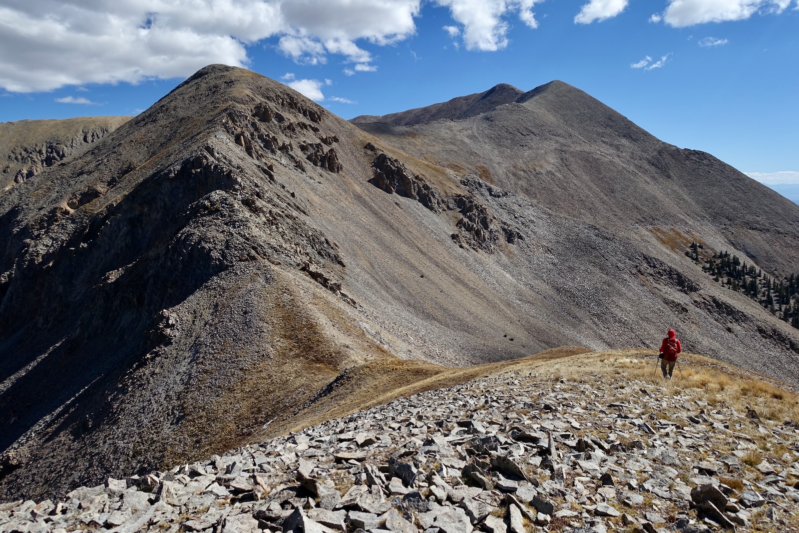
Arrive on the south ridge of Blackhawk at 4.6 miles, 12,300 feet. Whitecap is finally visible. It took us 1:25 to cover the one mile to the summit from here. I am no longer fast and most experienced hikers intent on the peak will be stronger and swifter than me. But this is not a passage to rush. We were 15 minutes quicker on the return to this point.

We cut west on a very subtle game trail while losing a little elevation. We were feeling the route out as we went and it was coming together beautifully. Be sure to peruse the Aspen Creek basin as you walk along its headwall.

Intersect the southwest ridge of Blackhawk at 4.8 miles, 12,220 feet. The route to Dolores Mountain, the lowest of the Ricos on the east block, diverts in this area. Meanwhile, our ridge makes an S turn, heading south to start.

Stay on the ridge as it turns west for an incredibly pleasant stroll through a fellfield. Fell is the Gaelic word for stone. Fellfield communities are stone fields, less than half covered with plants, generally cushion plants like moss campion and dotted saxifrage over which the wind flows easily. Yes, you could cut the corner but don't! It has its rewards.

Tap the true corner at 5.0 miles, 12,220 feet, and turn south with just a little over half a mile remaining to the summit. (THW, photo)

This shot of Dolores Mountain with the lengthy gray sill summit ridge was taken from the corner. The west block peaks starting from the left are: Landslip and Expectation mountains, Anchor Mountain, Eagle and Calico peaks, unranked Johnny Bull Mountain, Sockrider Peak, and the tallest of the set, Elliott Mountain. (THW, photo)

We made every effort to stay on the ridge crest. Below, I'm approaching the narrowing divide. (THW, photo)

While the terrain drops 200 feet overall in the next 0.3 mile, there are some significant stone knobs that must be mounted. Scrambling is Class 2+ to begin. Plates of stone sound like clanging dishware. The first challenge is a somewhat exposed Class 3 scramble.

We went straight up the center.
Below, I'm over the top of the warmup knob with plenty of room to play on its south side. (THW, photo)

The drop to the west is chillingly sheer.

In the foreground of this image is the contact line between a red band of Cutler and gray sill. Beyond is the saddle and the first of two walls.

Bypass the red gendarme on the east, dropping no further than necessary, and arrive in the 12,020-foot saddle. This image looks back at the gendarme from the base of the first wall. (THW, photo)

Here's a closeup shot of the wall, perhaps 50 feet in height. If it was any steeper the mountain would fall back on itself. The rock is shattered and literally, teetering. Climb this one with the lightness and grace of a fairy. Test everything and be reluctant to trust anything. Brace, don't pull. I got to the top and thought, "Well, that was one of the most badass things I've ever done." But it was soon to be superseded! (THW, photo)

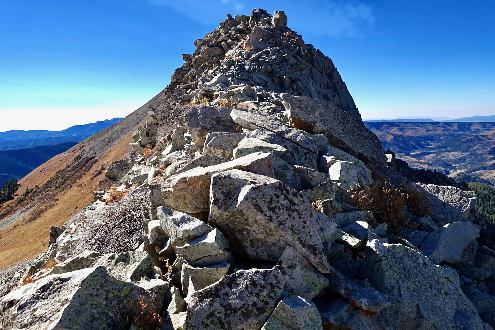
The ridge shrinks to a short knife on top of the wall.

The mountain offers a moment of reprieve, widening itself out across a stable blockfield.

And then, the totally unexpected, a flat of tundra turf snug up against the base of the 150-foot summit cone. The initial ramp pitched reasonably enough to the start of the crux (at the arrow), another fiercely steep, almost vertical 50-foot wall. Again, the rock looked ready to cut loose with the slightest touch. I found the setup intimidating. My partner graciously offered to retreat if I wanted to turn back. I paused and asked the mountain permission to proceed. I got a strong yes so I asked for its protection. We dug deep and mustered up the courage to give it a shot.

Looking at the image below, we decided to climb the razor instead of the dangerous debris gully to its right. I led, lightest person first, with my partner in lock step. We talked constantly. What worked, what didn't. Three quarters of our holds failed. But just enough reliable blocks propelled us up the mountain.

The cone rounds off. (THW, photo)

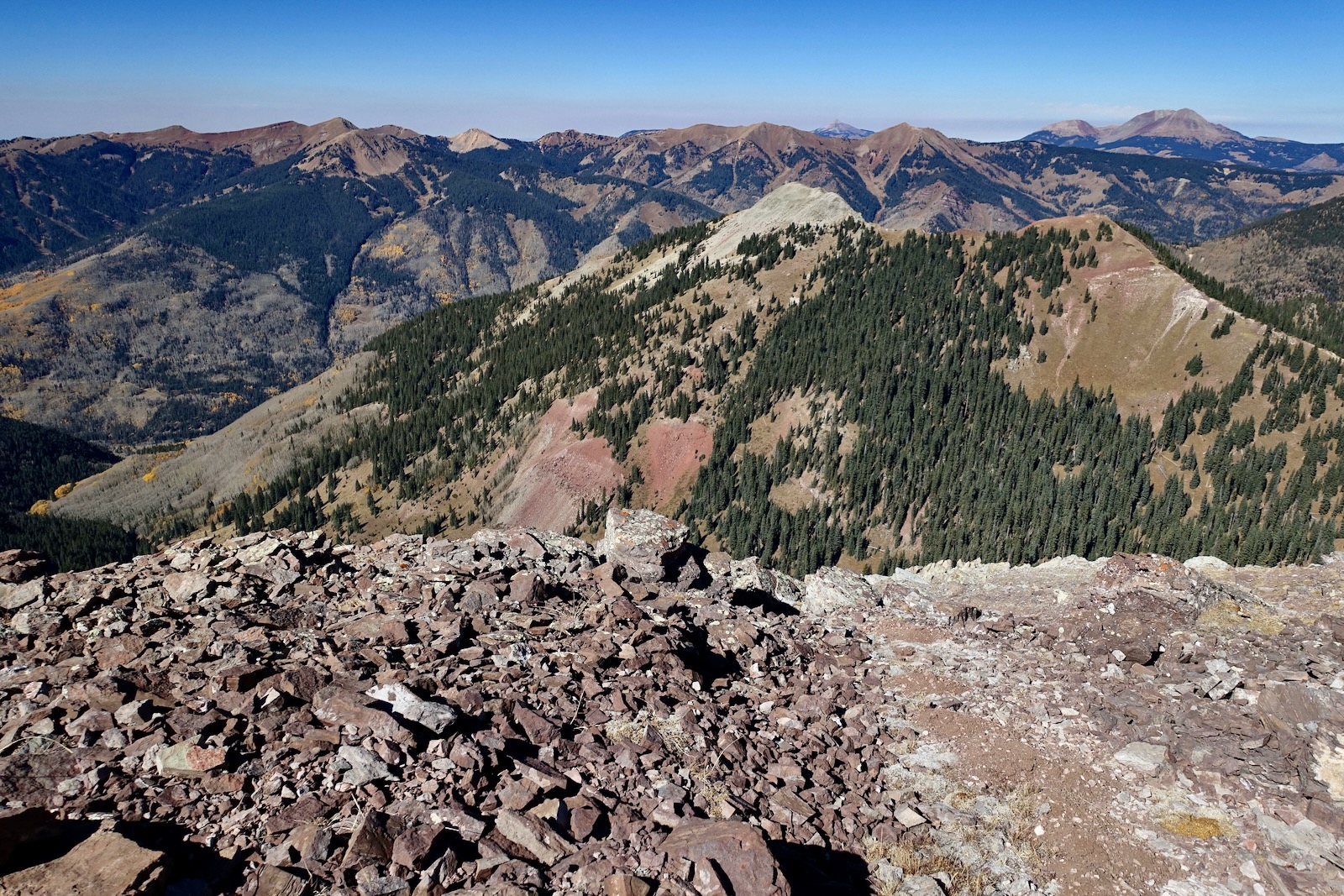
This image looks down on the access ridge from the roundoff. Burnished red Cutler, gray sill, golden grasses, and dark green spruce interweave to create an Earthen tapestry. El Diente Peak and Mount Wilson are due north and not all that far away. (THW, photo)

We topped out on the surprisingly roomy summit at 5.5 miles. The purpose of this blog is to document the American West, not me, but this image captures what this mountain will do for you. It will fill you with ecstatic joy. (THW, photo)

The register was placed in 2007. I am in awe of those who have climbed Whitecap repeatedly, and the few and true mountaineers for whom Whitecap was just one of four mountains climbed in a single day from Rico: Dolores, Blackhawk, Harts, and Whitecap. We were the first to sign in 2023. Ah, so that's why we were encouraged to summit--the mountain was lonely. Below, on the skyline are the La Plata Mountains and Sleeping Ute. (THW, photo)

We had intended
to climb Dolores but were running out of time on this short-light day. To the northwest Lone Cone is pictured in the saddle between Sockrider and Elliott. On the right is the challenging trio in the San Miguel Mountains.
East of the Animas River trench are the myriad peaks in the inexpressible Weminuche.

Downclimbing the cone and traversing the north ridge was trouble-free: done it once, can do it again; five points of contact available; better visuals; secret passages remembered and re-enacted. (THW, photo)

Clambering down the lower wall was good sport.

Back on the south ridge of Blackhawk, if you'd like to diversify your trip, shoot down through the basin. Favor the north side to stay clear of willows. Intersect the CT at the sweeping, four-mile turn. During the third week in October it was quiet out there. We saw a handful of mountain bikers on the CT and a couple of hikers getting a late start on Blackhawk. This was our last peak of the season in Colorado. We look forward to returning yet again to the Ricos to climb Dolores next summer. (THW, photo)