Monday, August 30, 2021

Middle Babcock Peak, 13,180': Highest of the Babcocks

Essence: The three, steeply-pitched Babcock peaks are separated by deep, impassible crevices. Although they are tightly packed, each presents wildly different challenges for the climber. Middle Babcock, the tallest of the three and only ranked summit, is accessed from Boren Basin. Begin on a lengthy, cobbly track. Pitch up a rubble slope into the confines of a couloir with large, unstable material. Alight on the tipping point between the Boren and Tomahawk basins. The approach over, finish with a Class 3+ fantastical scramble on good rock with serious exposure. This is a classic La Plata Mountains climb for experienced mountaineers in groups of two or three. 2023 Note: Based on new, more accurate measurement technology, LiDAR, the elevation of Middle Babcock has been reduced to 13,161 feet.
Travel: From the US 160/550 intersection in Durango, travel 11.0 miles west on US 160 to Hesperus. Turn right on La Plata Canyon Road, CR 124, and measure distance from there. After passing the hamlet of Mayday the road turns to smooth dirt at 4.6 miles. There are several established campgrounds in this area. Park in a pullout on the right at 8.1 miles, just past Boren Creek and about 200 feet before FSR 794.
Distance and Elevation Gain: 7.3 miles, 3,950 feet of climbing
Total Time: 5:30 to 8:00 
Difficulty: Jeep track, off-trail; navigation challenging; Class 3+; serious exposure; steep, unstable slopes; helmets recommended
Map: La Plata, Colorado 7.5' USGS Quad
Latest Date Hiked: August 30, 2021
Quote: So, if you cannot understand that there is something in man which responds to the challenge of this mountain and goes out to meet it, that the struggle is the struggle of life itself upward and forever upward, then you won’t see why we go. What we get from this adventure is just sheer joy. And joy is, after all, the end of life. We do not live to eat and make money. George Leigh Mallory

There is an impassible gap between East Babcock (where the photographer is standing), and Middle Babcock. Shown, is the climber's ridge to Middle's zenith. Beyond, is West Babcock, the Knife, and Spiller Peak. 
(Thomas Holt Ward, photo) 

Route: Hike northwest up the Boren Creek Road into the basin. Leave the road and climb north into the couloir between Middle and East Babcock peaks. Scramble up the southeast ridge to the summit. 

From the pullout, elevation 9,240 feet, walk up La Plata Canyon Road about 200 feet and head northwest up Boren Creek Road, FSR 794. The rough and rocky footbed is ameliorated by the riffling creek to the south, luminous aspen, lush wildflower-infused hillsides in summer and goldeneye toward autumn. Cross Shaw Gulch at 0.5 mile.

At 1.7 miles, 10,480 feet, the route to Burwell Peak branches left. Burwell, shown, is not a ranked summit but it is the southern highpoint on the rim of Boren Creek Basin with far-flung views to the west. Stay on the main track deeply shaded by Colorado blue spruce. (THW, photo)

The route to Middle Babcock leaves the Boren Creek Road at 2.8 miles, 11,300 feet. The peaks on the high-angle north wall of the basin run in quick succession. Pause and take a moment to get clear about what you are looking at and to locate the proper route. Looking at the image below, on the far left is the crux of the Knife at the “tooth,” the south wall of the Knife, West Babcock with the smooth stone swale (image-center), Middle Babcock, the climbing couloir, “4th Crest,” and East Babcock. To further confuse the matter, the La Plata quad labels East Babcock as Babcock Peak, 13,149’. And yet, Middle Babcock is the highest of the trio at 13,180 feet.

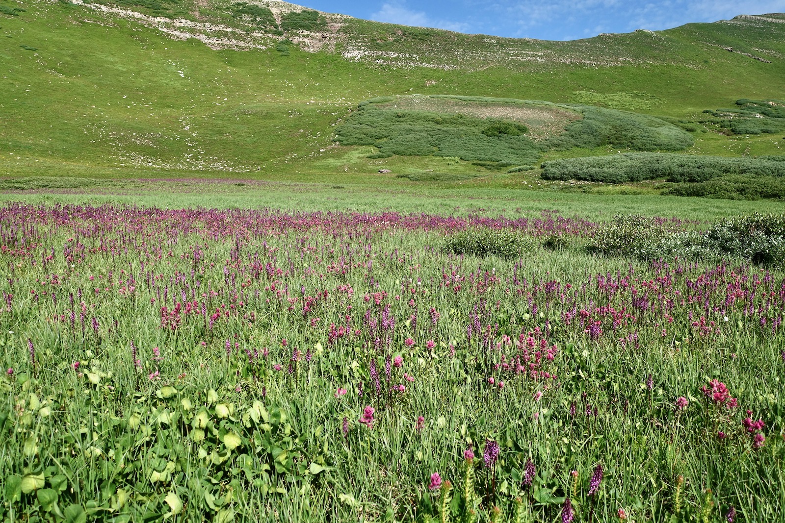
The off-trail segment mounts 1,880 feet in less than 0.9 mile. To get started, hike north through the krummholz staying on the turf as best you can. The initial climb is arduous and eventually tedious on a combination of grass, scree, talus, and boulders. At 12,000 feet, the pitch steepens and talus rolls out from underfoot. 

Note of Caution: We once witnessed two, three-foot cubes of stone cut loose from a Babcock couloir and, gathering more boulders, bounce-fly at 100 mph down the center of the basin where we had been moments prior. They skidded to a halt just shy of the jeep track. It was a narrow and lucky miss. Please be fully aware that your presence in the basin is potentially dangerous.

Several couloirs pierce the north wall. As a sanity check, the one you want is pictured below with an open sky "V" at its head. Middle Babcock is directly to its left and 4th Crest is to the right. (THW, photo)

Enter through the gates of the Middle Babcock couloir at elevation 12,460 feet. (THW, photo)

Boulders in the chute are abraded and easily activated. Climb in lock-step. The west wall has better grip than the east; make use of its secure holds.
 
The passageway curves left and keeps on going.

The couloir ends at 12,900 feet, 3.5 miles, in a cleft between 4th Crest and the southeast ridge of Middle Babcock. The cliff-framed vista restricts the field of vision to a slim, solitary tower and a narrow gash plummeting into Tomahawk Basin.

The summit is 0.15 mile afar. For experienced scramblers, the journey from here is pure pleasure. However, hikers with a fear of heights should turn back now. To access the southeast ridge of Middle, pitch up the ramp a few feet southwest of the tipping point. (THW, photo)

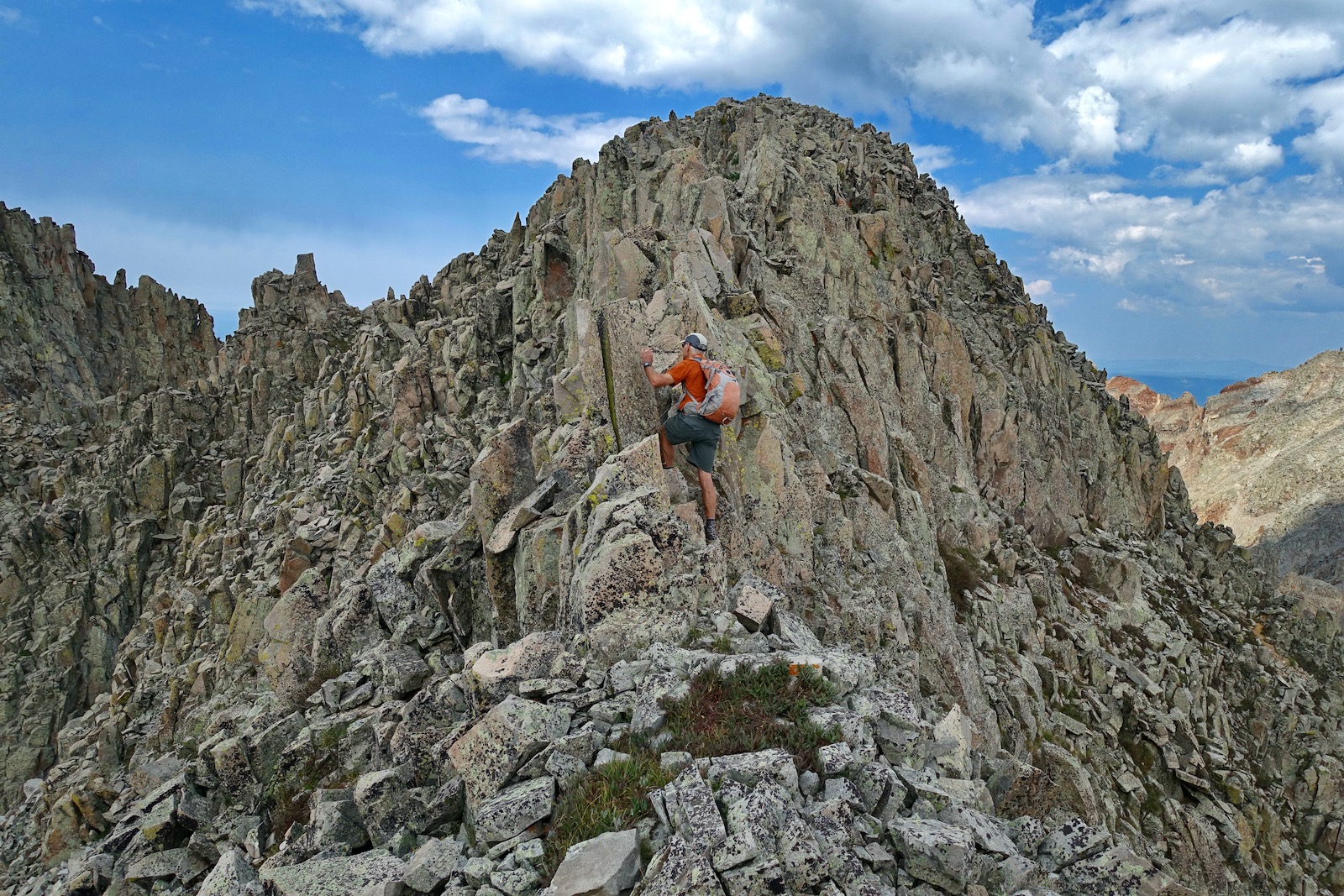
The southeast ridge hurtles down and terminates in the cleft. The corresponding Class 3+ terrain is steepest for 120 feet above the ramp. Most holds are good and solid but test them all the way to the summit. The route is not cairned; make mental notes of your approach so you don't overshoot the ramp on the downclimb. (THW, photo)

The grade softens and the razorback constricts. As always, stay right on the ridgecrest unless forced off momentarily. (THW, photo)

These scramblers are approaching the crux which initiates at two stone pillars. The Middle Babcock summit is pictured on the right and West Babcock is on the left. And yes, there is an impassible crevice between them. (THW, photo)

I have climbed Middle four times and have tried different tactics at the crux. I always hug my way around the pillars, shown. Then, once I stayed right on the spine and the three other times I was slightly off-ridge on the north. Friends have stepped down to the south before the pillars for a longer bypass. All choices are seriously exposed and some would argue a move or two is Class 4. Return to the ridgetop at first opportunity.

This image looks east to East Babcock Peak (roughly 0.1 mile away), Silver Mountain across La Plata Canyon, and a climber polishing off the best part of the adventure to Middle Babcock Peak. Arrive on the narrow, compact crest at 3.65 miles. 

The five ranked La Plata thirteeners are all tucked into the northern tier of the West Block. They include banded Hesperus Mountain, the three towers of Lavender Peak, and the northwest cornerstone of Tomahawk Basin, Mount Moss. It goes without saying, Middle Babcock is in the brotherhood of wild heights, as well as Centennial Peak.

West Babcock is but a stone's throw away across a fearsome gap. Spiller Peak is at the west end of this east-west ridgeline dominated by the Babcock peaks. (THW, photo)

The downclimb from the peak to the road typically takes as much time and effort as the ascent. These hikers are working down the southeast nose aiming for the ramp. (THW, photo)

This image depicts the top of the couloir, the intimate balance point between two major basins in the La Plata Mountains. The hikers are contemplating the unavoidable slick slide down the ramp and into the couloir. (THW, photo) 

Hold your concentration in spite of any physical fatigue or mental monotony. Discombobulated boulders slide at the slightest touch. If the weather holds, be sure to visit the obvious orange outcrop a good way down toward the road. Walk out the top line of stone and balance on the miniature pedestal. Watch for eagles and peregrine falcons in the upper basin. 

Monday, August 23, 2021

Sharkstooth Peak, 12,462'

Essence:  Sharkstooth Peak is climbed by a small percentage of adventurers who utilize its namesake trail and for good reason. Slithering, shattered, and chaotic, this mountain is for list completers and the courageous who can't resist the magnetic pull of the little rock pile and its remarkably sharp summit. Ultra steep slopes slide out from underfoot, holds are undependable; self arrest is problematic. I climbed this peak a second time only because I needed better route information. We spirited all over the summit cone to locate the safest passage. There are other conceivable routes but they are a roll of the dice. Navigation must be carefully deliberated and nuanced. Climb with no more than two or three sure-footed partners. 
Travel: In a 4WD vehicle with good clearance, from the US 160 and CO 184 signal in Mancos, turn north on CO 184 toward Dolores and measure distance from there. In 0.3 mile, at the sign for Mancos State Park, turn right on Montezuma CR 42. At 5.5 miles, the road becomes FSR 561, West Mancos Road. Pass the Transfer Campground at 10.3 miles where pavement ends. Stay on FSR 561 at 11.1 miles. Pass the Aspen Guard Station at 11.9 miles. Roll through a mature aspen and ponderosa forest and turn right at mile 12.4 on FSR 350, Spruce Mill Road. It remains smooth and graded until mile 18.8. Turn on the right spur signed for the Twin Lakes, Sharkstooth trailheads, FSR 346. The next 1.5 miles require 4WD and good tires. The track is rocky with potholes. There is dispersed camping along the road with ponds and a terrific view of Hesperus Mountain. One third of a mile before the trailhead, the road runs along the base of the Sharkstooth rock glacier. The trailhead is 20.3 miles from Mancos. Allow 1.5 hours from Durango. The small parking area holds six vehicles. 
Distance and Elevation Gain: 4.4 miles; 1,600 feet of climbing
Total Time: 3:00 to 4:30
Difficulty: Trail, off-trail; navigation challenging; Class 3 with considerable exposure; rockfall hazard, helmets recommended. 
Map: La Plata, Colorado 7.5' USGS Quad
Latest Date Hiked: August 23, 2021
Quote: There’s three types of fun. Type 1 fun is stuff that’s fun to do and fun to talk about later. Type 2 fun is stuff that’s not fun to do, but it’s fun to talk about later because you survived it. Type 3 fun is stuff that’s not fun to do and not fun to talk about later. Kyle McDowell (You decide.)

Sharkstooth Peak's punishing reputation repels most hikers. A few climbers can't resist the temptation of its elemental, all-stone fierceness. I will describe what I believe is the safest route but the mountain is unpredictable and there are no guarantees. The risk is yours. 

Route: Hike east on the Sharkstooth Trail to Sharkstooth Pass. Off-trail, ascend north-northeast until you are looking directly at the west face of the peak. Pitch east up a shallow gully that sheds from a notch a few yards south of the summit. 

Sharkstooth Trail #620 is one of three trails that compose the Mancos Spur. It connects the Western La Platas with the Highline Loop Recreation Trail and the Colorado Trail. The well-established pathway leaves from the east side of the parking lot at elevation 10,900 feet.

The trail skirts the southern runout of the Sharkstooth rock glacier. Picas forage amongst the rocks; a magnificent Colorado blue spruce holds back rolling stone. 

Toward the end of August, the woods spoke of impending autumn. After a wet summer, mushrooms were everywhere. Elderberries were an even brighter red than the crimson leaves of fireweed. Osha and delphinium were transitioning from flower to seed. Cobalt blue bottle gentian, the harbinger of winter, spoke to the passage of summertime. 

Cross a tributary of the North Fork of the Mancos River on a big, sturdy log at 0.8 mile. Hesperus Mountain, the tallest peak in the La Platas at 13,232 feet, is the banded, laidback triangular slab seen through a break in the timber.

At 11,650 feet, pass above treelimit into the alpine tundra, "...sharp and bare and open, brightly lighted, a land of few shadows." (Land Above the Trees, by Ann Zwinger and Beatrice Willard) Switchbacks moderate the grade, our quarry comes into view, and the trail takes direct aim at the Sharkstooth/Centennial saddle. 

Arrive on Sharkstooth Pass, 11,936', at 1.8 miles. (Note: The charming, hand carved Sharkstooth Pass sign went missing in 2021.) Here we leave the Sharkstooth Trail which continues east over "Bear Creek Pass" to link up with the Colorado Trail at Taylor Lake near Kennebec Pass. For most hikers, the pass is a marker on their way to Centennial Peak, 13,062', just 0.8 mile south. 

From the pass, Sharkstooth Peak is a 526-foot climb over 0.4 mile. In 2010, I did the roundtrip climb in fifty minutes, but only because I climbed with a skilled navigator who dialed the route without any go-backs. (Eleven years have since passed and neither of us can recall his route precisely.) Most climbers will take 1.5 to 2.5 hours, roundtrip. To begin, head north on the softly rounded ridge until you have a direct shot at the west face of the mountain. Resist the urge to barge up the south face. Yes, some people have been successful using this approach but it is more unstable than the recommended route.  

Route Overview 
The real challenge begins 200 vertical feet from the top. The summit cone is a small, even intimate, space and the route must be deciphered carefully. Looking at the photo below, the safest passage, and most likely the standard route if there is one, is to climb the shallow gully emanating from the notch right of the apex. 

Work your way up and into the gully. At 12,080 feet, the mountain bucks up but the slope is reasonably stable and doesn't get rigorously steep and loose until 12,200 feet.

The fractured rock is poised at the angle of repose. The rock tends to settle in cresting waves--avoid disturbing them. The worst danger is setting off a landslide above you. Navigation is a sustained puzzle. We made progress a dozen feet at a time, readjusting with micro route finding. Soft dirt passages are one clue you are on course.

This image looks down on the gully, more of a debris slide path. The floor of the trough is more stable than the splintered ribs on either side. There are a few good holds but most become dislodged when stepped on or pulled.

This image looks up-mountain from the exact location where the previous photo was snapped. There is no bypass around this exposed Class 3 wall. (Thomas Holt Ward, photo)

 The wall ends at a funnel that drains from the notch. (THW, photo)

From the gap it is a short, straightforward walk to the zenith. (THW, photo)

Appropriately, the 4X5 foot fang is the smallest crest of any peak in the La Platas, a good part of its allure. The hard won vantage point has an incomparable view of three thirteeners: Centennial Peak, Lavender Peak, and Hesperus Mountain. (THW, photo) 

Swing from Lone Cone eastward to see the San Juans rippling off in the distance. Indian Trail Ridge, the skyway connector between the ranges, is across the Bear Creek Basin. Our friend, Ranger Ott, placed the peak register in October, 2020. About a dozen people have signed since. (THW, photo)

La Plata's largest rock glacier surges out in waves from the peak and its northwest ridge. Burro Mountain, the most northerly ranked summit in the range is an extension of this ridge. Like Sharkstooth, it is a remnant of immensity, the structure that stood in this very place before the forces of erosion had their timeless way. (THW, photo) 

Note on Northwest Ridge
We had heard over the years that the peak was not accessible from the northwest ridge. We wanted to check it out so we did a lateral across the west face and climbed to a small saddle at 12,260 feet, a stunning and dramatic place on the razorback of the rock glacier. We were able to climb about 100 feet on the ridge until we were stopped by a 20-foot cresting wave of rock. (THW, photo)

From the access road perspective, Sharkstooth Peak owns the expression, "Small but mighty."

Saturday, August 7, 2021

Peak 12,703' (E1) and Peak 12,766' (E2) from Coal Bank Pass (or Jura Knob)

Essence: Long miles on a popular trail, then an undemanding off-trail loop to two ranked peaks. The ridge between the mountains is one of several compelling features of this hike. We passed by E1 and E2 many times over the years; there were no trip reports for either prominence. In July, 2021, we made it to the 12,300-foot saddle before getting weathered out. Our successful hike in August, 2021, yielded an even better route than we anticipated but the triumph was diminished by a sky laden with smoke from wildfires across the Western U.S. We returned on July 11, 2023 and rehiked E1 and E2 via Jura Knob. See the end of this post for a map and statistics. Based on new, more accurate measurement technology LiDAR, the elevation of E1 has been increased to 12,718 feet with a rise of 401 feet. E2 is now pegged at 12,774 feet with a rise of 326 feet giving it ranked peak status.
Travel: From Durango, drive north on U.S. 550 for 35 miles to Coal Bank Pass. Turn left/west 0.1 mile north of the pass (mile marker 56.9) onto a dirt road that leads to trailhead parking. There is a seasonal outhouse on the east side of the highway but no water.
Distance and Elevation Gain: 15.5 miles; 3,950 feet of climbing
Total Time: 7:00 to 9:00
Difficulty: Trail for 12.9 miles and off-trail for 2.6; navigation moderate; Class 2+ with no exposure
Map: Engineer Mountain, Colorado 7.5' USGS Quad
Latest Date Hiked: July 11, 2023
Quote: The earth laughs in flowers. Ralph Waldo Emerson

E1 and E2 frame a ridge west of Jura Knob and east of Cascade Creek. The Colorado Trail wraps around the prominences on the northwest. (Thomas Holt Ward, photo)

Route: From Coal Bank Pass, hike generally east on the Pass Trail. Walk north on the Engineer Mountain Trail until just shy of the junction with the Colorado Trail. Climb the east ridge of E2 and then traverse south on the ridgeline to E1. Continue south and intersect the White Creek Trail. Hike northeast to the junction with the Engineer Mountain Trail and retrace your steps. The blue line represents an alternate route to (or from) the saddle. E1 and E2 refer to an alpha-numeric naming system on the 15 minute Engineer quad. E3 and E4 are nearby, often climbed with Jura Knob. 

Pass Trail (aka Pass Creek Trail)
The Pass Trail begins at elevation 10,660 feet and launches immediately into flower insanity. The summer monsoons were so powerful in 2021, corn husk lily and green gentian were easily seven feet tall. Their ivory blossoms, along with big-platter cow parsnips, were offset by purple delphinium and Whipple's penstemon, yellow little sunflower, and orange Indian paintbrush. This is surely one of the consistently best floral landscapes in the Southern Colorado mountains. 

The flowers are living on an avalanche slide path. Beyond the winter peril, the trail delves into deep spruce woods hanging above U.S. 550. The weathered Paleozoic limestone in the area is a sedimentary layer tilted by the San Juan uplift. Sea creature fossils impregnate the limestone boulders. Pass a reflection pond undergoing the time-honored Earth process of turning into a meadow.

If you have an affection for queen's crown, turn off on a short spur at 1.5 miles and you will find them beside a talkative brook. (THW, photo)

Emerge onto the Engineer Plateau at the "Bus Stop," a sitting log with a view of Engineer Mountain

Engineer Mountain Trail
The Pass Trail ends at the junction with the Engineer Mountain Trail (EMT), elevation 11,660 feet, 2.5 miles. The deeply etched north face of Engineer Mountain casts long shadows in dawn light.  

Walking north, at 3.0 miles the trail gives up 150 feet going into the Coal Creek depression. This is the first of many undulations on this pathway. At 3.55 miles, the Coal Creek and Deer Creek trails branch to the east. Stay straight on the EMT. The interplay of old spruce stands and wildflower-infused meadows is sublime. Magenta paintbrush was featured in July. Just three weeks later, three varieties of cobalt blue gentian were showcased--little, bottle, and fringed. Both peaks and Jura Knob (far right) are visible from this meadowland perspective. 

After climbing to 11,800 feet, the trail loses another 300 feet as it drops into the Engine Creek drainage. The path falls and rises as it negotiates streamways on the west slope of Jura Knob. A filament of water falls into a moss and fern-laced grotto at 5.0 miles. There is an excellent view of the southeast ridge of E1 from the trail. We gave serious thought to using the ridge as a descent strategy but it was too troubled with cliffs. 

Arrive at a signed three-trail junction at 5.4 miles, 11,500 feet. The Engine Creek Trail joins from the south. The White Creek Trail, favored by mountain bikers, goes west around the south end of E1 and links with the Colorado Trail (CT). The EMT points north and terminates at the CT east of E2. To initiate the loop described here, go north on the EMT. 

The EMT grinds uphill keeping the stairstep cascades of Engine Creek to its west. The water emanates from a cluster of ponds in a glacial basin east of the small divide linking E1 and E2.

The first time we attempted the peaks, the weather blew up so we abandoned our loop plan and made for the saddle, shown. We walked on a gray limestone rim which deposited us into thick stands of willows and extensive bogs. If the saddle is your intention, leave the EMT at the distinctive red bench. This route is discussed more thoroughly later. 

E2, Peak 12,766'
At 6.5 miles, 12,200 feet, leave the EMT and ascend the east ridge of Peak 12,766', staying just north of the willow line, shown. This image was shot from the west slope of Jura Knob. (THW, photo)
 
From the ridge, look down on the junction of the EMT and the CT. The benchland south of Twin Sisters is riddled with tarns. The bright cluster of tents is an aid station for the Silverton Dirty 30. It was an unfortunate day for a hike (August 7, 2021), let alone a 100-mile footrace. The smoke from wildfires burning vast tracks of land further west was oppressive and dispiriting.

The east ridge climb is mellow. Some flowers are especially notable mid-summer. Watch carefully for pygmy bitterroot, Lewisia pygmaea. The plant is so close to the ground its succulent leaves and pink flowers are easily missed. "Lewisia" refers to Meriwether Lewis (leader of the Lewis and Clark Expedition) who collected the first specimens for science in Montana in 1806. (THW, photo)

Once we went searching for and found Colorado tansy aster on the south ridge of Jura Knob. So it wasn't a surprise to see it thriving on the east ridge of E2. It is a U. S. Forest Service Rocky Mountain Region Sensitive Species and its existence is threatened. 

The ridge tightens briefly at 12,500 feet and then opens onto a broad platform just before the summit. The finish is charming with little green pathways between red, coarse-grained Cutler Formation boulders. Alight on E2, at 7.1 miles.

Saddle 12,300'
The traverse between E2 and E1 is the most enjoyable segment of this long trek. Hop across a small talus pile and then meander on tundra passages through more granular boulders. (THW, photo)
 
Clamber through and around deep cracks in iron stone--big, bold, shattered and jumbled. Green lichen clings to the sharp-edged mustard and black angular blocks. The gentle roller north of the saddle was covered in the scat and stench of a domestic sheep herd bleating away by the thousands on the slopes of E1 and in the basin in August of 2021. (THW, photo)
 
Drop into the saddle at 7.8 miles. This vantage point features a sensational perspective on the southeast ridge route up Grizzly Peak west of the massive Cascade Creek drainage. Rolling Mountain that truly does go on forever, is image-right. 

Red Bench Route to EMT
If you need to bail from the saddle, it is a simple 1.1 mile hike east to the EMT. Jura Knob, E3, and E4 are seen east of the trail.

Locate the game trail that leaves from the saddle and does a descending traverse to the southeast for 0.3 mile. 

Staying above the marsh, curve to the northeast and walk on the red bench all the way back to the EMT. Look out over the best of willow-infused bog world: rills; tarns; and magenta paintbrush, queen's crown, and elephant head.

E1, Peak 12,703'
There is a sheep trail right on top of the north ridgeline. The climb is obstacle-free, easy going, and mostly tundra--nothing to it. We rounded out on the expansive smooth summit dome of E1 at 8.2 miles. (THW, photo)

South Ridge to White Creek Trail
We had planned on returning to the saddle but the sheep were a deterrent and we were curious about a possible route down the south ridge to the White Creek Trail. We had no idea what the cliff features would throw at us. 

If you intend to follow this route, be sure you are descending on the south ridge and not the cliff-ridden southeast ridge, or the southwest ridge which leads to the historic (and vanished) Highline Trail. You'll know you are on the correct ridge if you are walking directly toward Engineer Mountain, shown.

Starting down the gamble, we could see the White Creek Trail below. The white cliff band at 12,400 feet was broken and posed no problem. (THW, photo)
 
At 12,000 feet, we were standing on top of a mountain-wrapping Cutler cliff band, the same rock that composes the Class 3 Corner Wall on Jura Knob. We started probing to the west and discovered an animal path treading through a weakness in the wall. We got very lucky--it would have been a brutal go-back on a long, smoky trek. We no longer heard the sheep, there were elk tracks everywhere, and we had a clear shot to the White Creek Trail. All right! This image looks back up at the cliff from the White Creek Trail. (THW, photo)

Return to Pass Trailhead
We contacted the White Creek Trail at 9.1 miles, 11,570 feet, and turned northeast. This EMT to CT connector follows the contour, a welcome interlude on this hike. 

Cross Engine Creek, a dependable water source, just before closing the loop at the three-way junction at 10.1 miles. Retrace your steps from there. As it turns out, the south ridge route was 0.6 mile shorter than returning by way of the 12,300-foot saddle. Reserve sufficient energy for the roughly 550 feet of vertical accumulated on the return to the Engineer Plateau. Platter-sized boletes were growing near the creek during a soggy summer. (THW, photo) 

There is a lot of exposure to lightning on the EMT. By mid morning in July, it was raining with lightning strikes close by. We jogged most of the way to the trailhead but stopped to take a photo of this woods' rose on the Pass Trail. They put out the best fragrance on earth. 

We once again passed through Flowerland just feet from the trailhead.

Jura Knob Approach
We began on the Coal Creek Trail, climbed Jura Knob, then E2 and E1. We returned on the White Creek Trail, Engineer Mountain Trail, and Coal Creek Trail. The distance was 13.1 miles and the accumulated gain was 4,160 feet. It was 1.4 miles shorter than the Pass Trail approach but added 200 feet of gain. Please link to Jura Knob for a description of the Coal Creek Trail and peak.

E1 from the south ridge of Jura Knob.

Be aware that there is a tough Class 3 climb at the Corner Wall near the Jura Knob summit. The wall is impossible for dogs (and some solo hikers).