Essence: Hike on a series of trails to Pete Mountain, a tree-clad cone north of Mount Hopkins on the west flank of the Santa Rita Mountains. Walk blithely along on a contour trail to Jack Mountain (unranked with a 200-foot rise), tucked low between Mount Hopkins and Mount Wrightson. While the hike is forested throughout, it features astounding views. Pause on the quiet trail to contemplate elder junipers and towering sycamores. Extensive segments of the route are quite steep. The hike is within the Mount Wrightson Wilderness, Coronado National Forest.
Travel: There are three Green Valley exits from I-19. Watch for a brown sign for Madera Canyon Recreation Area and exit on Continental Road. Turn east under the interstate and cross the Santa Cruz River. In 1.2 miles, turn south on White House Canyon Road which transitions to Madera Canyon Road. Cross three, one-lane bridges. The paved road steepens and ends at 12.8 miles in a multi-layered parking lot at the Madera Canyon Picnic Area. Loop around and park near the Old Baldy Trailhead located in the upper lot on the east side. Pay the day use fee or display your National Interagency Pass.
Distance and Elevation Gain: 8.2 miles with 3,240 feet of climbing for both mountains.
Total Time: 5:00 to 7:00Distance and Elevation Gain: 8.2 miles with 3,240 feet of climbing for both mountains.
Difficulty: Trail; navigation moderate; Class 2 with no exposure; avoid when snow clings to the north slopes of Mount Hopkins or carry traction devices.
Maps: Mount Wrightson; Mount Hopkins, Arizona, 7.5' USGS Quads
Date Hiked: March 3, 2021
Quote: Do not forget that the value and interest of life is not so much to do conspicuous things...as to do ordinary things with the perception of their enormous value. Pierre Teilhard De Chardin
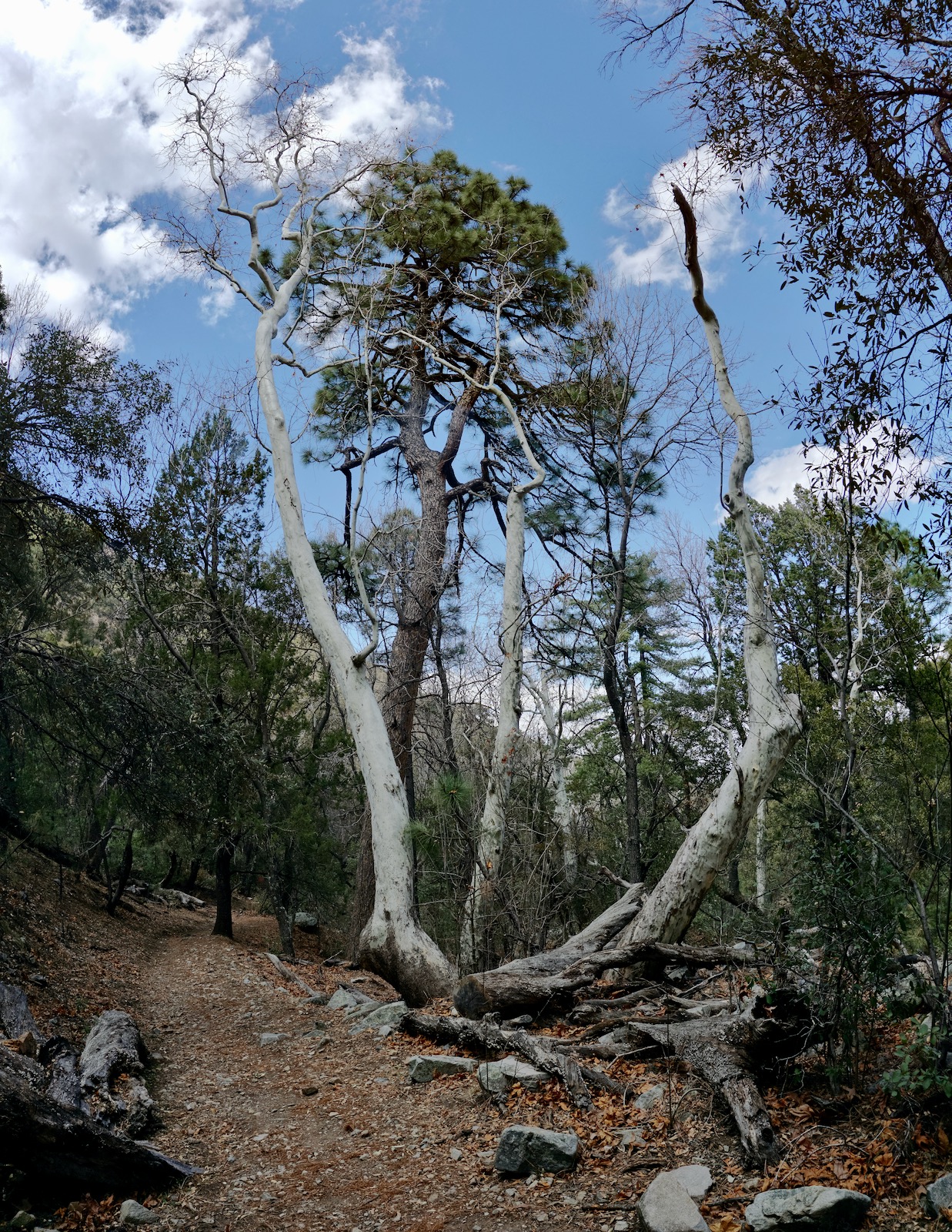
Pete (shown) and Jack mountains are humble summits relative to their Santa Rita companions but this hike has hidden treasures awaiting discovery. (Thomas Holt Ward, photo)

Route: Walking south, quickly transition from the Old Baldy Trail to the Vault Mine Trail. Mount southwest to the Agua Caliente Trail and turn northwest. From Agua Caliente Saddle, take a social trail past Bearpaw Rock, over Point 7,390', and climb Pete Mountain. Return to the junction with the Vault Mine Trail. Stay on the Agua Caliente Trail, walking the 7,360-foot contour for 1.6 miles. Pass the upper terminus of the Carrie Nation Trail and intersect the north ridge of Jack Mountain. After climbing Jack, return to the Carrie Nation Trail and descend into Madera Canyon and back to the trailhead. My thanks to "fricknaley & Jeffshadows" for their post in Hike Arizona. They helped me sort out the trail system. Their wild enthusiasm for this hike is infectious.

Signs out on the trail do not post either the Vault Mine or Carrie Nation trails. However, they are depicted on the signboard at the trailhead, elevation 5,460 feet. Begin by hiking south on the Old Baldy Trail.

Leave the Old Baldy Trail at 0.25 mile and continue straight, following the sign toward Agua Caliente Saddle. This is the beginning of the Vault Mine Trail, the (Very Steep Trail). The stoney two-track ascends into the Mount Wrightson Wilderness.

In March, 2021, Southern Arizona was suffering through a prolonged and serious drought. We didn't see even one wildflower and the creek in Madera Canyon was stone dry. Puzzle-bark sycamore trees were lined up defining the course of the the normally flush waterway. On our return we encountered a group of birders with binoculars watching for the Elegant Trogon, the showiest of 250 bird species found in Madera Canyon. Crossing the creek at 0.6 mile would be potentially hazardous during normal runoff.

The Carrie Nation Trail begins at a signed junction at 0.7 mile, 5,900 feet. This hike returns on the Carrie Nation. For now, hang a sharp right just past the sign, staying on the Vault Mine Trail. Neither trail is posted on the sign which is doubly confusing because it points in the same direction for two disparate locations.
The Vault Mine Trail climbs southwest up the wall of Madera Canyon on a lateral ridge, pitching up 1,400 feet in one mile. The dirt footpath is dug into the highly angled slope with tight switchbacks; it's steep but not oppressive. There are mesmerizing views of the Santa Rita Crest through periodic openings in a climax forest of madrone, oak, and ponderosa. At 6,900 feet, pass a mine shaft bored into solid rock. (THW, photo)

The Vault Mine Trail intersects the Agua Caliente Trail at 1.7 miles, 7,320 feet. The historic sign is highly crafted but not terribly helpful. It reads 0.8 mile to Agua Caliente Saddle but it is just 0.3 mile to the northwest. Give up 60 feet on a gorgeous trail with far-flung views. Reach the signed saddle at 2.0 miles, 7,260 feet in a serene grove of massive alligator junipers. Look for an unofficial trail heading northwest out of the saddle. It is not engineered but perfectly serviceable and trimmed. This would be a thrasher without brush maintenance.
Bearpaw Rock is located about 100 vertical feet and a tenth of a mile from the saddle. An artist etched a lightning bolt flashing from a bear's mouth and two paw prints. I was unable to unravel the mystery of this panel. It rests in a boulder pile right on the trail; you can't miss it. (THW, photo)

A thin thread ascends 461 feet to the mountaintop. I like low profile trails that get the job done and nothing more. The pathway braids upon entering the rock. Watch for cairns and hold to the ridge as it curves west, staying well away from the cliffs to the south. Crest the summit cone at 2.9 miles after 2,500 feet of climbing. It was satisfying to be here after looking at Pete for many years from prominences all over the range. We could not locate a peak register. I had anticipated further exploring from the mountaintop but it was too brushy to be tempting. Still, the view of the wild heights on the Santa Rita Crest from McCleary Peak to Josephine Peak was sweeping. (THW, photo)

To the south, Rattlesnake Canyon plummets into Agua Caliente Canyon. Across the headwater basin is Mount Hopkins where astronomers probe the mysteries of the universe. The square-block Fred Lawrence Whipple Observatory is owned and operated by the Smithsonian Astrophysical Observatory. The MMT Observatory mirror was cast and polished by the University of Arizona in Tucson. (THW, photo)

Due west is a stone cluster on a ridgeline flowing south from Point 7,137', well east of Elephant Head. Baboquivari Peak melds into a blue and lilac pastel. (THW, photo)

Return to the Pete Mountain saddle and punch up the hill (puts the Very Steep Trail to shame) and back onto the Point 7,390' divide. The extraordinary contour segment on the Agua Caliente Trail begins at the junction with the Vault Mine Trail (4.1 miles) and continues southeast for 1.6 miles to the north ridge of Jack Mountain. The views are huge and the trail is essentially flat, a master stroke of engineering. Just cruising along on the 7,360-foot contour is relaxing and contrasts markedly with the hallmark of this hike found elsewhere--steepness. (THW, photo)

The treadway crosses periodic talus flows streaming down drainages. In early March, we encountered snow on the northeast slopes of Mount Hopkins. The exposure wasn't too bad but the footing was icy and it required concentration to stay on the trail. Wait for the snow to melt or take traction devices. (THW, photo)

Pass through a grove of towering aspen. To see an ancient alligator juniper, at 5.3 miles take a short detour south on a path. This witness tree, shown, stands just off the east ridge trail to Mount Hopkins. Arizona's "Giant Alligator Juniper" lives in the Prescott National Forest. It is over 2,000 years old, 46 feet tall, and 27 feet in circumference. (THW, photo)

Officially, the Carrie Nation Trail ends at the mine in Madera Canyon. Functionally, it continues up to the Agua Caliente Trail. The unsigned junction at 5.5 miles is 1.4 miles past the Vault Mine Trail. It plunges off to the left/northwest. We passed it by because we wanted to climb Jack Mountain, a minimal addition of 240 feet of vertical over 0.6 mile, roundtrip.
To climb Jack, continue 0.2 mile on the Agua Caliente Trail. When it tips over Jack's north ridge, ascend south on a thin social trail softened by pine needles. The summit is heavily treed but you can make out the shape of Pete Mountain. This little hilltop is the best Mount Wrightson lookout of them all. (THW, photo)

Josephine Peak keeps well hidden much of the time but Jack's got a timeless, uninterrupted view of her. (THW, photo)

Return to the Carrie Nation Trail at 6.1 miles and slam down a north-trending interior ridge in the upper reaches of Madera Canyon. A series of small switchbacks cut into soft dirt ameliorates the pitch. The trail gathers more chopped rock and debris as it descends. The path leaves the ridge and crosses Madera Canyon at 6.6 miles, 6,600 feet, shortly before the End of Trail sign posted for people walking up-canyon. This is the beginning of the maintained trail from the perspective of down-canyon hikers. The Mount Wrightson topo indicates a spring at this location.
Cross the creek and check out the Carrie Nation Mine. The adit was bored deep into the earth, disappearing into the darkness. Exploring adits is not recommended by this blog! Discarded mining equipment includes a boiler stamped "Indianapolis, IND, Henry B Front," a steam engine, piston, and drive wheel. The Carrie Nation Trail continues downhill on the west side of the streamway.

Communing with the venerable juniper was an unexpected pleasure on this hike. The sentinel, easily 800 years old, was hiding in plain sight just off the contour trail. (THW, photo)
