Travel: From Silverton, in a vehicle with 4WD low and high clearance, drive up the main drag. Measure from the junction of Greene Street and San Juan County Road 2. Stay on Greene Street, passing a sign for Silverton Mountain ski area and wind up the hill past Memorial Park. The road transitions to CR 110 and dirt at 0.8 mile. Drive northwest up the Cement Creek corridor. Pass Silverton Mountain at 5.7 miles. The road splits in Gladstone at 6.5 miles. Take the left branch toward (Corkscrew Pass) and Hurricane Pass, CR 10. The road deteriorates immediately to a serious 4WD track for the next three miles. It is an ultra narrow, steep shelf with limited passing opportunities, big rocks, bedrock ledges, and tight corners. Pass picturesque mine ruins. At 9.7 miles turn left at the sign: Dead End Spur, Alaska Basin. (CR 10 continues up and over Hurricane Pass.) The road improves. Park at the top of the hill, west of Point 12,947' at 10.3 miles. If you start taking a steep dive you've gone too far! Allow 45 minutes to one hour from Silverton. There was a parade of vehicles throughout the day on CR 10. Get an early start.
Distance and Elevation Gain: 7.6 miles; 2,500 feet of climbing
Total Time: 5:30 to 7:00
Difficulty: Off-trail with social fragments; navigation easy; Class 2+; moderate exposure on final approach to Abrams Mountain
Map: Ironton, Colorado 7.5' USGS Quad
Latest Date Hiked: August 11, 2020
Quote: The goldfinches and the tiny caterpillars, the brilliant sun, if looked at lovingly and thoughtfully, will lift the soul out of the smaller life of human care that is of selfish aims…into the greater, the limitless life which has been going on over universal space from endless ages past, which is going on now, and which will for ever and for ever, in one form or another, continue to proceed. Richard Jefferies, 1834-1887
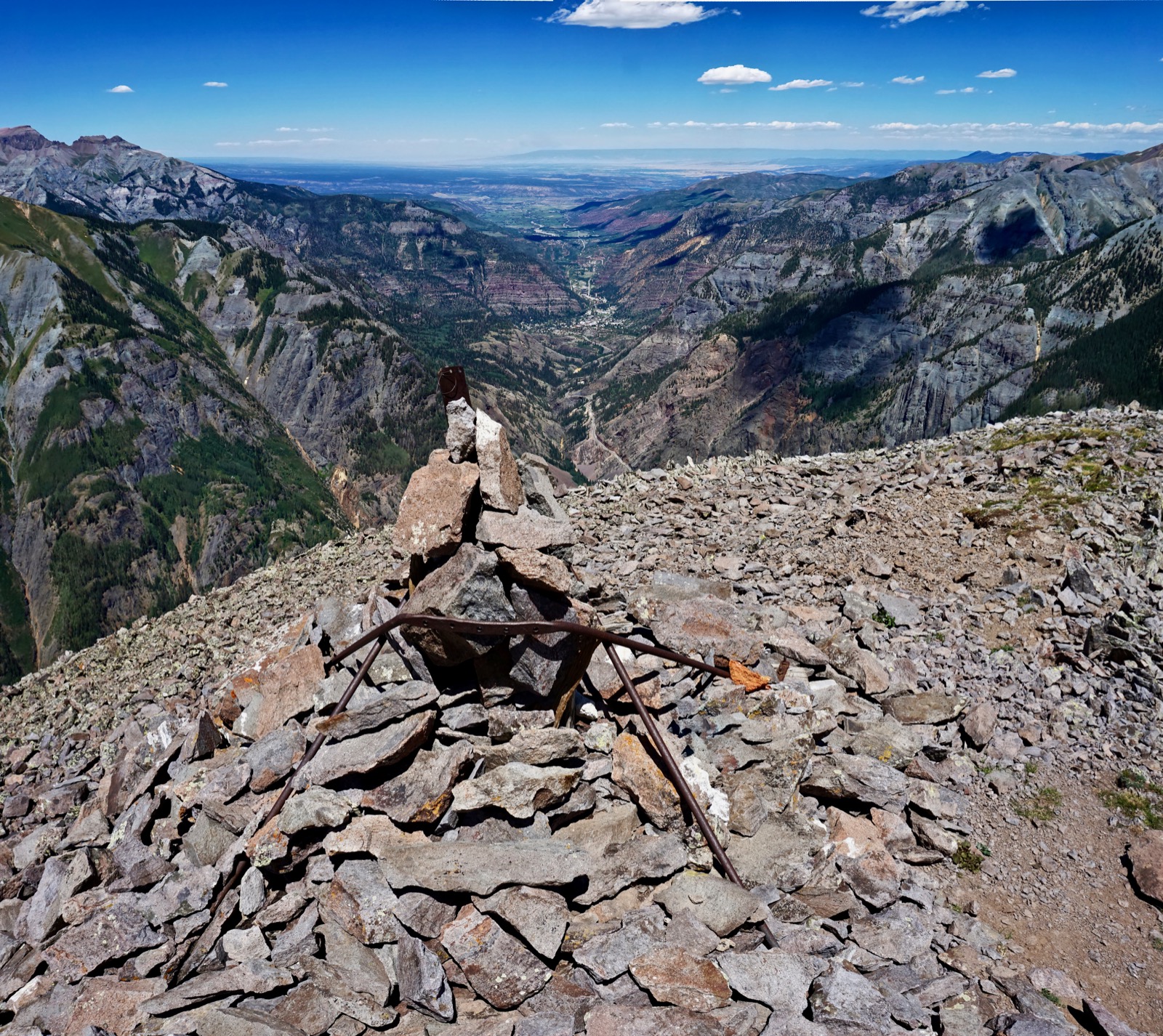
A whimsical sentry at the tipoff on the Abrams Mountain summit ridge looks down on US 550 winding through the Uncompahgre Gorge to Ouray. The Uncompahgre River joins forces with the Gunnison River in Delta. The waters blend with the Colorado River in Grand Junction and flow ever onward toward the sea. (Thomas Holt Ward, photo)
Route: From the parking pullout at Point 12,947' hike west up a lateral ridge to the Brown Mountain divide. Walk south to the Duco Benchmark, the highest point on the ridge. Traverse north over seven numbered points and climb Abrams Mountain. Reverse course back to the start.
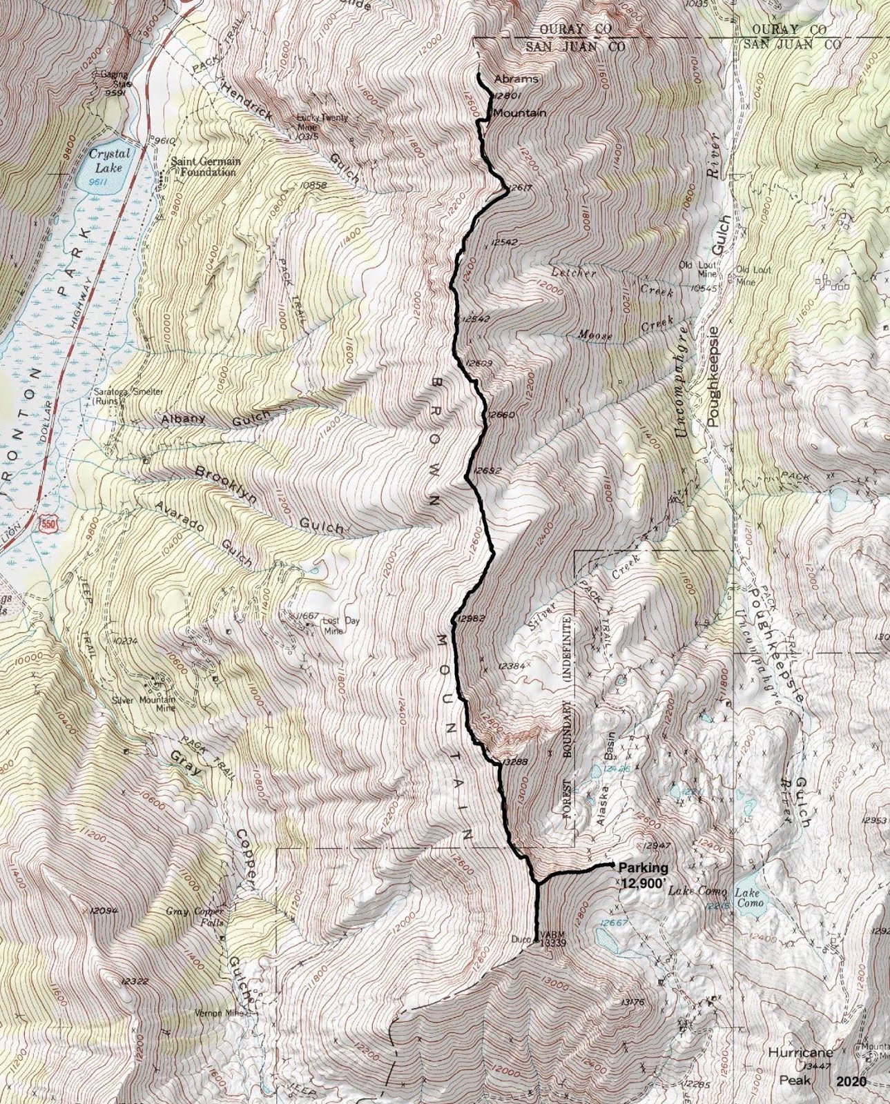
The parking platform, elevation 12,900 feet, is on an eastward ridge that forms a small divide. The lakes and streams to the north are in the Uncompahgre River watershed which roils through Poughkeepsie Gulch. Waterways to the south flow into the Animas River and take a much longer journey to reach the Colorado via the San Juan River. This is likely the highest elevation start for any hike posted on Earthline. Abrams Mountain is image-center. (THW, photo)

Cross the road and immediately begin climbing west up a lateral ridge to the Brown Mountain divide. The mix of tundra and loose rubble is typical of the tread surface throughout the hike. The ridge slopes off to the south and drops abruptly on the north.

Reach the divide at 13,300 feet after just 0.3 mile. Whether you are a seasoned local or up here for the first time, you'll have to suspend your disbelief when looking at fiery Red Mountain No.1, No. 2, and No. 3. The Reds lie on the north rim of the Silverton Caldera, twelve miles in diameter. It is one of fifteen calderas in the San Juan Volcanic Fields. The rock on the divide surface is sometimes referred to as San Juan Explosive Volcanics the result of massive volcanic ash flows. Looking further west, the views are already astonishing. This image spans from Rolling Mountain to Telluride Peak.

Duco Benchmark on Brown Mountain
Before heading north to Abrams, walk 0.2 mile south to the high point on the divide. You'll be glad you did this first because half of the hike's vertical is accumulated on the return trip. The ridge to Brown is somewhat narrow but not exposed.

The Duco 1952 Benchmark is a curiosity. Ouray County is west of the divide and San Juan County is to the east. You can see Trico Peak west of here where San Miguel County adjoins so there is precedent for naming prominent landmarks after county convergences. That's my best guess. The peak register was placed by a couple from Ridgway in August, 2020.

This is the only opportunity for a clean shot south. Corkscrew Pass winds up toward the Reds, image-right. Silverton Mountain ski area is directly above Gladstone culminating at Storm Peak. On the skyline is the sharply jutting Grenadier Range at the center of the San Juan uplift. Erosion has stripped away the sedimentary and volcanic overburden to expose quartzite basement rock.

Traverse to Abrams Mountain
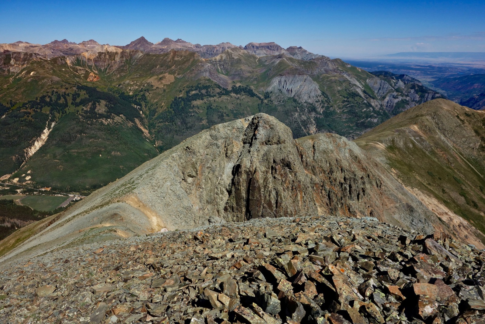
The traverse between the two ranked summits has a primarily downward trajectory with numerous ups and downs. (Abrams is 100 feet lower than the hike's starting point.) The first prominence, Point 13,288', has the greatest relief, 188 feet. The crest has a short section of clinking plates. The image below looks back on CR 10 climbing to Hurricane Pass, Hanson Peak, Hurricane Peak, the parking platform, the access ridge, and Duco Benchmark. The lake in the corner is in Alaska Basin. (THW, photo)

A major rock glacier flows out to the east between Point 13,288' and Point 12,982'. Take a moment to look west of the Uncompahgre Gorge to Mount Sneffles, Cirque Mountain, Teakettle Mountain, Mount Ridgway, and Whitehouse Mountain. Look directly down on Ironton and US 550 all the way along. Next up are two unnumbered knobs. The short descents are rather steep and loose.

Social trails flank some of the rollers as you progress north. For fun, we stayed on the ridge crest most of the way to Abrams (image-left) and used some of the bypasses on the return.

We walked on a tundra bench just west of the ridgeline because it was so appealing. (THW, photo)

We reached the lowest point of the hike, 12,420 feet, at 3.3 miles. Judging from tracks, elk frequent this area. In 2008, I saw a family of five ptarmigans. A thin trail flanks Point 12,617' on the east.

Resistant soil is slick as you come around to regain the ridge.

Personal note: I climbed Abrams in 2008. In 2020, I waited 200 feet below the summit while my partner finished the climb. I had hand surgery a month prior and with one arm elevated, I wasn't steady enough to do the bypass west of the outcrop shown below.
The exposure is rated moderate because footing is poor on a shelf trail for a short distance. The slope is steep enough that it would be hard to self arrest if you lost your footing. Once past the outcrop, pitch up the tundra to the Class 2+ stone knob. It's another 0.1 mile to the summit.

Crest Abrams Mountain at 3.9 miles. The park-like summit is broad, flat, and grassy. Abram Cutler was the first judge in Ouray County in the 1870s. Both the mountain and Cutler Creek were named for him.
Geological Note: The Cutler Formation is a complex of bright-red sandstones and pink grits and conglomerates alternating with shales and limestones, also in varying shades of red. The alluvial sandstones shed southwest from the Uncompahgre highlands into the Paradox Basin. The Cutler Group was laid down in the Early Permian and is spread across southwest Colorado, northwest New Mexico, southeast Utah, and Arizona. The name originates from exposures on Cutler Creek, a tributary of the Uncompahgre River. The confluence is four miles north of Ouray. (THW, photo)

The summit ridge extends another 0.1 mile north to a second peak register tucked in a stone and scavenged metal sculpture at 12,740 feet, image-right. Ouray is in a glacial-carved, deeply incised valley. Rising above town in this image are the Bridge of Heaven and The Amphitheater. (THW, photo)

There is an unobstructed view of numerous fourteeners including the highest in the San Juan Mountains, Uncompahgre Peak, image-right. (THW, photo)

Southwest Colorado is experiencing an on-going drought in 2020. By early August, most of the flowers had already gone to seed. We saw isolated blossoms: alpine avens, magenta paintbrush, Fremont senecio, pink
aster, moss campion, deep rooted spring beauty, old man of the mountain, dotted and snowball
saxifrage, harebell, bottle and Arctic gentian, and lupine.
Abrams Mountain from Ouray, October, 2023. (THW, photo)

Abrams from US 550 a few miles south of Ouray, October, 2023. (THW, photo)
