Friday, April 29, 2022

Crack and Chute Canyons, San Rafael Reef

Essence: Walk through two slim canyons that have excavated passageways through the San Rafael Reef. Some corridors are straight and long, others sinuous. Pass between colorful tapestries interweaving a remarkable tafoni texture and water-polished smoothness. The clockwise loop includes an optional road section; Crack Canyon, beautiful all the way through with three stretches of narrows; a fast overland trek across the San Rafael Desert; and a stroll up obstacle-free Chute Canyon. Hiking is mellow except for two Class 3 downclimbs in Crack. The region is administered by the BLM. Most of the hike is within the 26,000-acre Crack Canyon Wilderness Study Area. No bikes, no vehicles. 
Travel: From I-70, Exit 149, drive south on UT-24 for 24 miles. From Hanksville, drive 19 miles north on UT-24. Turn west on Temple Mountain Road following the sign for Goblin Valley State Park and measure distance from there. At 5.0 miles continue straight where the road to Goblin Valley heads south. Pass the South Temple Wash Campground and enter the Muddy Creek Wilderness. The road turns to dirt at 6.2 miles. Pass the Temple Mountain Townsites Campground. If these campgrounds are full, there is plenty of dispersed camping further along the route. Turn left on Behind the Reef Road at 7.1 miles. Sturdy tires and moderate clearance are necessary to reach the Crack Canyon Trailhead at 11.1 miles (on the left). To run a shuttle or walk the entire circuit, the Chute Canyon Trailhead is another 2.3 miles. The road between Crack and Chute is comparable. Cross into Little Ocean Draw Wilderness at 11.4 miles. Cross the sandy Chute Canyon wash at 12.9 miles. Park at the signed Chute Canyon Trailhead at 13.4 miles. The dispersed camp across from the trailhead was a shaded ice box in April. No water or facilities at either trailhead.
Distance and Elevation Gain: 10.5 miles with 500 feet of vertical for Crack, the overland route, and Chute. The road from Chute to Crack adds 2.3 miles and 500 feet.
Total Time: 5:00 to 7:00 for the complete circuit
Difficulty: Jeep road, canyon floor, trail; navigation moderate; Class 2 except for the Class 3 drops in Crack; no exposure; significant flash flood hazard; seasonal pools. Carry all the water you will need and hike on a cool day.   
Maps: Temple Mountain; Goblin Valley; Little Wild Horse Mesa; Horse Valley, Utah 7.5' USGS Quads 
Latest Date Hiked: April 29, 2022
Geology: The San Rafael Swell is located in the northwest quadrant of the Colorado Plateau. The Swell is a dome-like upwarp or anticline formed about 65 million years ago and measuring 75 miles long and roughly 30 miles wide. Tectonic forces buckled sedimentary layers into the broad fold. The upwarp is gently inclined on the west but the rocks on the eastern edge are tilted up on end in a monocline, the San Rafael Reef. With relatively little elevation change, the hike down Crack Canyon passes through successively younger classic formations associated with the Colorado Plateau. The easily eroded, colorful Chinle Formation underlies sheer-walled Wingate Sandstone. Ledge-forming Kayenta Formation is overlain by beige, Navajo Sandstone domes and towers. The tour of rocks is reversed on the return up Chute Canyon.
Haiku:  
Days of thunder pass,
Sweep a lace of stone and void,
Night blooms Datura.
    --Thomas Holt Ward
 
Hikers transition from the eternal shadow of storm-carved depths into luminosity in ethereal Crack Canyon. (Chris Blackshear, photo)

Route: The circuit is typically run clockwise to mitigate the challenges in Crack Canyon. Minus a shuttle, park at the Chute Canyon Trailhead and walk generally northeast on Behind the Reef Road to the Crack Canyon Trailhead. Walk south-southeast until the canyon walls recede. Hike southwest across the San Rafael Desert and drop into Chute Canyon. Hike north in Chute, closing the loop at the trailhead.
  
Chute Trailhead (elevation 5,140 feet) to Crack Canyon Trailhead 
For hikers without a shuttle, the stretch between the trailheads is 2.3 miles with 500 feet of uphill and takes 45 minutes to an hour. It is a good call to get this segment out of the way first thing. Traffic is negligible early in the morning and sunshine gathers in Crack Canyon while you are walking. Below, early light accentuates whimsical Wingate towers holding down the Chinle Formation.
 
Behind the Reef Road has long strips of scraped bedrock. I've included this photo so drivers have a sense of whether their vehicle is up to the task.
 
Leave the Little Ocean Draw Wilderness. Chute Benchmark, 6,508' ("Chute Buttress"), emits a strong presence.
 
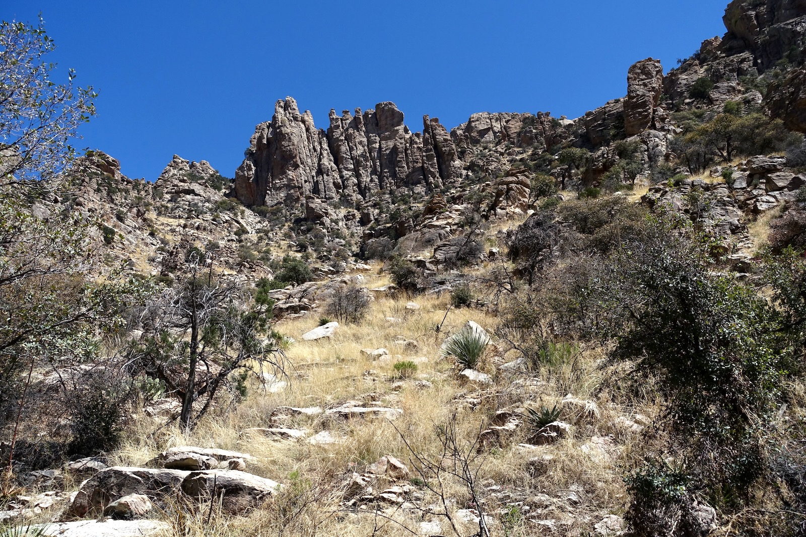
Crack Canyon Trailhead (elevation 5,480 feet) to Canyon Exit
This segment of the loop is about 3.8 miles with 480 feet of elevation loss. Weekdays are quiet; weekends, busy. Word is out about one of the sweetest canyons in existence. Start out on a two-track heading south toward a yawning gap in the San Rafael Reef.
 
At 0.5 mile, leave the road in favor of the canyon floor. Downclimb or bypass the first minor obstacle down-canyon right.
 
Cross the contact between the Chinle Formation and Wingate Sandstone. Walls immediately soar 400 feet overhead. Light casts a double reflection. The wall in shadow is illuminated by sun reflecting off the opposite wall. 
(Thomas Holt Ward, photo)
 
Wingate Sandstone is one of the "big three" formations comprising the Glen Canyon Group. Wingate, Kayenta Formation, and Navajo Sandstone are viewed from a broader and even finer perspective on the Waterpocket Fold in nearby Capitol Reef National Park. Cliff-forming Wingate is red-orange with streaks of desert varnish.

In Crack Canyon, Wingate Sandstone has composed a veritable symphony of extraordinary tafoni. The polygenetic origin of the connected networks is poorly understood but is thought to result from a complex interaction of physical and chemical weathering processes. Tafoni develops in a wide range of rock types. In the Wingate, acidity in rainwater dissolves calcite, the bonding agent of sandstone, thereby creating and enlarging the cavities. The tafoni madness one mile into the hike is as good as it gets on the Colorado Plateau. (THW, photo)

Flash floods deposit pebbles and larger debris in the cavities. This highly textured wall in upper Crack is a source of amusement for hikers of all ages. It is just the beginning of an exquisite array of tafoni throughout both Crack and Chute canyons.

A string of Navajo Sandstone towers fascinate at skyline. (THW, photo)

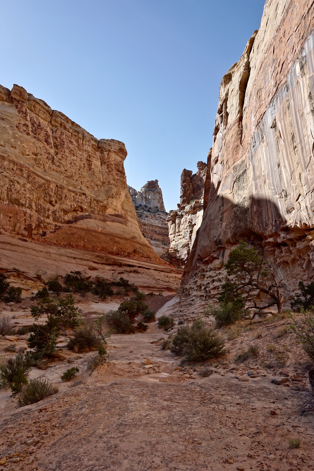
Over the coming miles, the canyon opens and constricts repeatedly. The first set of narrows at 1.2 miles begins with an entrance tunnel. (THW, photo)
 
A testimony to the power of water, the ceiling is undercut and overhung, the floor and walls sculpted. (THW, photo)
 
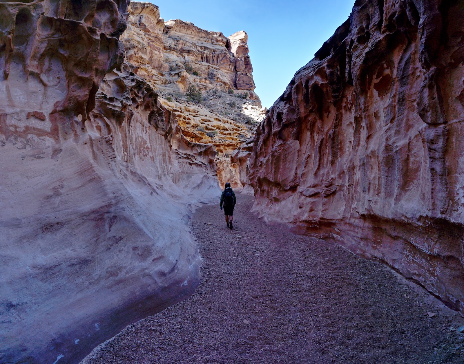
The canyon is ceaselessly mesmerizing. Forms are exquisite and varied, the surrounds are quiet and peaceful, even sensual. (THW, photo)
 
The geological formations on the monocline tilt up to meet the hiker. Though we've descended minimally, below I am walking through the ledge-forming Kayenta Formation. This is the rock that creates all the Class 3 excitement in Crack Canyon. (THW, photo)
 
By definition, a slot is so tight the average human can touch opposite walls with hands outstretched. Crack doesn't meet that standard but it constricts into a pseudo slot at 1.7 miles. The first Class 3 downclimb is a triple-tiered drop at about two miles. The eight-footer is made more challenging because the boulders serving as holds are rounded and smooth. Some hikers will need a spot. The drops commit you to the full loop unless you are skilled with up-climbing. 
(THW, photo)

This image looks back on the pitch. The next two moves in the series are inconsequential unless they are pooled; be prepared to wade after rain.
 
 Stone reaches out to embrace a passer by. (Chris Blackshear, photo)

Walls and towers strain to close the gap between them. (THW, photo)
  
Some will find the second Class 3 obstacle more difficult than the first. We braced off the walls to negotiate the ten-foot drop.

Walls are subtly overhung in this tunnel-like segment. Sun gleams on a few lucky spots when days are long. Fluted walls, gravel floor--idyllic. (THW, photo)

Upon entering Navajo Sandstone the canyon widens. Micro fractures in the formation have created one rounded dome after another. The whole scene reminds me of Bell Canyon which pierces the monocline five miles west as the crow flies.
 
Utah-blue sky predominates as the canyon punches through the east side of the Reef. There is a side canyon on the right 0.15 mile before the exit route. (THW, photo)
  
Overland Trail Across the San Rafael Desert
A sign at 5,000 feet in elevation directs to Chute Canyon. The overland route is 2.3 miles with 160 feet of climbing and takes about one hour. The trail cranks 180 degrees and lifts off the canyon floor.
 
The footpath bears southwest across the face of the Southern Reef. It is well-established for the most part but braided in places. If you find yourself on a loose end, retreat and locate the main track. The immediate landscape isn't super appealing but the long-range vista is outstanding. In 2022, the persistent drought in the West coupled with relentless wind created a dust-laden haze. Even so, we could see Goblin Valley and the Henry Mountains. The wide-open traverse puts the two canyons in context. (THW, photo)
 
Come alongside a tributary of Chute at 4.7 miles. A cairn marks an alternate route down into the tributary. We stayed on top until we were 2.2 miles into the overland route. The trail was vague right where you need to drop into Chute Canyon. Descend a sandy hillside and arrive on the canyon floor at 6.1 miles, 4,820 feet.
 
Lower Chute Canyon to Chute Trailhead 
The trek through Chute Canyon is 4.4 miles with 320 feet of rise. Head north upcanyon. In just 0.3 mile the corridor constricts to 20 feet and barrels up a long straightaway with a uniform gravel floor.
 
The canyon becomes sinuous, meandering lazily. I felt as if I was inside a caldron of gold. (THW, photo)
 
Bulbous walls soar overhead. Navajo Sandstone looks like a pot of boiling stone, folded and irregular.

Elephant skin on the Kayenta Formation gives it a living presence in this hiking theater. (THW, photo)

The canyon widens and the Kayenta presents in chaotic disarray. Blocks are poised to give way but the jumbled mass holds together somehow, at least in this moment. 
 
Delicate lace tafoni on vertically-walled Wingate Sandstone supplants disordered Kayenta. (THW, photo)
 
Chute swings past a major amphitheater. Below, the Wingate overlies purple Chinle Formation in this tilted world. Leave the Crack Canyon Wilderness Study Area 1.25 miles from the trailhead. Finish on a 4WD track.
 
This daring leap in Crack Canyon was captured by friend and photographer, Chris Blackshear.

Wednesday, April 6, 2022

Point 6,060' Ridge, Esperero Spires, Mount Miguel, 4,340'

Essence: Point 6,060' is the highest column in a cluster of monoliths known to the climbing community as Esperero Spires. They are poised high on the divide between Esperero and Bird canyons on the Catalina Front. Access the south ridge of Point 6,060' from the Esperero Trail near Cardiac Gap. This is a classic Pusch Ridge divide hike with mind-bending views and two sets of standing rocks. Finagle through a challenging maze of walls and outcrops. Point 6,060' is a technical climb but you'll get very close on sublime Point 5,980', a solid block of stone. The trek concludes with an optional climb on the three prominences of Mount Miguel from Cardiac Gap. This hike is within the Pusch Ridge Wilderness, managed by the Coronado National Forest.
Travel: Begin from the overflow parking lot for Sabino Canyon Recreation Area. From the signal at the corner of Sunrise Drive and Sabino Canyon Road in Tucson drive north, passing the main entrance and following the sign for overflow parking. Turn right at 0.4 mile on paved FSR 805 at a sign for Southern Arizona Rescue Association. Drive through the gate and park in the northwest corner. Fee required. The pay station and privy are located by the trailhead for the park on the east side of the lot. No water! Gate opens at 6 a.m.
Distance and Elevation Gain: Esperero Spires out-and-back, 9.0 miles, 3,500 feet; Mount Miguel adds 0.5 mile and 250 feet 
Total Time: 6:00 to 8:00 depending on route
Difficulty: Trail (4 miles), off-trail (5.5 miles); navigation challenging; Class 2+ with mild exposure; wear long pants; be on the lookout for rattlesnakes; carry all the water you will need and hike on a cool day. 
Map: Sabino Canyon, AZ 7.5' USGS Quad
Pusch Ridge Wilderness: This hike lies east of the Bighorn Sheep Management Area so those restrictions do not apply. Dogs are not allowed in the Pusch Ridge Wilderness.
Latest Date Hiked: April 6, 2022
Poem:
I have been in many shapes
   before I attained this form.
I have been a drop in the air,
I have been a shining star.
A bridge for passing over
   three score rivers.
I have journeyed as an eagle,
A boat on the sea.
I have been many things...
--Taliesin, b. 534
 
It's not a stretch to imagine that the silent standing sentinels seen here from the highest reaches of the Esperero Trail were created from the stars.
 
Route: From the overflow lot hike on-trail to Cardiac Gap. Segue off-trail to the Point 6,060' divide and hike north to the Spires. Return as you came. The climber's plunge on the purple-line bailout route to the Esperero Trail is discussed but not recommended. Simple instructions for climbing Mount Miguel on the blue-line route conclude the post.
 
 
The standard Esperero Trailhead is located 0.7 mile from the Visitor Center at the Sabino Canyon Recreation Area (water, restrooms). This description avoids the hubbub and asphalt road by taking an unnamed trail frequented by locals to connect with the Esperero Trail. It shaves a mile each way and does not appear on maps.
 
I won't belabor the segment to Cardiac Gap. If you are considering this hike, you've no doubt been there countless times already. Walk northwest out of the lot, elevation 2,820 feet. The trail materializes in a sandy, open area. Flora is immediately Sonoran beautiful with signature saguaro, staghorn and teddybear cholla, prickly pear, brittlebush, palo verde and ocotillo. Below, hikers are looking at a cristate saguaro a short distance west of the trail. The Esperero Spires are visible from the parking lot and lower trail, image-center.

Important! At 0.3 mile the trail splits. Take the left fork and climb swiftly on swaths of bedrock. The highpoint of the shortcut trail has sweet views of town and Mount Wrightson to the south, Rattlesnake and Breakfast canyons to the east, and Bird Canyon to the west. Turn left on the Esperero Trail at one mile.
 
Switchback down into Bird Canyon, cross it at 1.3 miles, and climb to the crest of a ridge to its west. Contour into an unnamed tributary of Bird. Cut across it several times over the next mile to Cardiac. Of note: at 2.2 miles, two canyons join in a quiet, beautiful garden. The descent of Mount Miguel's east ridge rejoins the trail a few paces further on.

Continuing upward, the footpath leaves the canyon floor for good reason. The trail bypasses a 100-foot vertical, water-stained headwall with undercut caves. After storms a waterfall blasts over the pouroff. Enter the Bighorn Fire burn scar shortly before Cardiac. In June, 2020, a lightning strike ignited the fire on Pusch Ridge. By July, it had incinerated 119,987 acres. By April, 2022, invasive and opportunistic bufflegrass had infiltrated entire hillsides.
 
Alight on Cardiac Gap, elevation 4,420 feet, at 2.8 miles with about 1,800 feet of vertical already put away. It's easy to understand why this is a favorite fitness hike for locals. The grade is serious and consistent. Plus, the views over southern Arizona and on high to Cathedral Rock (image-left) are stellar. Stay on the trail to flank the end cap of the south ridge of Point 6,060'. Going over the top of it offers no advantage. 
 
Leave the Esperero Trail 0.15 mile beyond the Gap at a small hoodoo, 4,540 feet, and ascend northeast. 
 
It's a quick jump from the trail to the ridgeline. In 2021, the scorched earth was heartbreaking; even the barrels were burned leaving paper thin sea urchin forms. Easy walking free of undergrowth provided minimal consolation. In 2022, the ridge was clogged with grasses so thick and tall they were hard to plow through. The notorious Arizona blazing star (the dreaded Velcro plant) was an irritating nuisance. This image looks back on the end cap composed of stacked stones.
 
Walking north, two ridges run in parallel. The spine further east comes up from Point 4,863'. At 3.3 miles, 5,100 feet, they join forces at this stone hallway. You may pass through--into an alternate quantum reality? It is a powerful place. (Thomas Holt Ward, photo)

Emerge from the other side and you may feel you are on a pilgrimage to Stonehenge for on the next knob is a circle of eight standing stones.
 
Together, the formations are a harbinger of the Esperero Spire megaliths. The stacked rocks are reminiscent of the innumerable Catalina Granite rattles on Rattlesnake Peak. They are boulder inselbergs, resistant remnants of bedrock left on the surface as erosion wears back the mountain front. Weathering and erosion have enlarged sets of vertical and horizontal joints, dividing the bedrock into individual blocks. Weathering widens and deepens the joints and rounds the corners and edges of the blocks. (THW, photo)

At 3.6 miles, 5,400 feet, the divide splits again. Transfer to the ridge on the east, crossing a small drainage between them.

Soon, the ridgecrest is stripped down to big blocks and slabs. It's great fun to see which outcrops you can pass over and which leave you cliffed out. The wild spire-topped ridge across deeply incised Bird Canyon is a southwest spur off the principal south ridge of Rattlesnake Peak
 
Walk the rim to see whimsical creatures suspended over oblivion. (THW, photo)

At 5,600 feet, movement is complicated by a maze of walls, outcrops, and crevices. Confront a broad rib of rock at 4.0 miles. Navigation from here is a game of probes and missteps. Our first feeler just to the west of the nose left us cliffed out. Below, Point 5,980' and the crests of the two tallest monuments at Esperero Spires are visible.

Eventually we found a viable route west of an unusual and distinctive apricot-colored weathered fin wall, an important landscape marker. (THW, photo)
 
The passageway west of the wall got us to 5,700 feet. The next section is a steep, boulder-filled slot. Progress doesn't come easy. Just wiggle around heading north-northwest and eventually you will come to an accommodating ramp, shown.

Our goal on the second visit was a small stone prominence south of the main tower cluster we knew we could climb, Point 5,980'. First we scampered up its sub peak. Don't miss it!
 
Approach Point 5,980' from its north ridge. Avoid this hike when there is any chance of snow accumulation. In January, the east slope of the prominence was covered in a sheet of snow and moving about without an ice ax was treacherous. Nothing blocks a plunge into the canyon 900 feet below. On our hike in April, the exposure didn't register but it is there.

At 4.5 miles bliss out on Point 5,980', a series of rounded domes with a supreme vista. Captivating attention are the monoliths ahead. Looking at the image below, the tallest tower, Point 6,060' with a rise of 200 feet, is on the left or south. The vertical-walled rectangular stack to its right is the shorter north tower. Ranging further out is the ridge leading to Cathedral Rock, the Esperero-Ventana divide, Window Peak and Rattlesnake Peak just across the way.
 
I recommend turning around here and retracing your steps to Cardiac Gap. We hoped to find a Class 3 route up any of the towers so we went to investigate. We tried crossing the land bridge on the ridge cap but it soon cliffed out. So we flanked the spine tightly on its west. The soil was soft so footing was good, otherwise this would have been a risky ploy. Use caution. We didn't look on the east side of the bridge for a less exposed passage.
 
Back on the boulder-covered ridge, we were soon within a colonnade of free-standing ziggurats and longstones. We were able to squeeze between vegetation and the east wall of Point 6,060' to arrive on a tiny saddle between the south and north towers. 

Point 6,060' was sheer on all sides save a small weakness on the northeast. Definitely not Class 3. (THW, photo)
 
We dropped about 20 feet to the east and walked around the north tower but we couldn't find a scrambler's pitch anywhere.
 
I had read in Mountain Project that climbers walk four miles up the Esperero Trail and then "bushwhack to the climbs."  Curious, we decided to take the plunge, dropping 1,000 feet in half a mile on the purple-line route. We used an ultra steep, rubbly gully that pinches into a pouroff toward the bottom that must be bypassed. Sure enough, we reached the Esperero Trail two miles north of Cardiac. We were plastered with Velcro plant. This route is almost a mile longer than the ridge route and requires a 200 foot climb back up to the Gap. There was no evidence of recent climbing traffic at the Spires even though they have a powerful appeal from the trail.
 
Mount Miguel, 4,340' 
Return on the trail from Cardiac Gap or climb Mount Miguel. It is unranked with 120 feet of prominence. Below, it is the third rise on the descending ridge. We found it easiest to walk around the base of the block box starting on the north side. Be careful while hanging ultra high above Esperero Canyon. Then track south along its west side. On the south end there is a fun C2+ scramble up a crack with good holds. Views are fabulous from the box and it was the most enjoyable climb of the three.
 
It was simple enough to get up the middle knob but we had a heck of a time proceeding from there. It is best to retreat and bash through brush on its east side. It was rather unpleasant and slow. (THW, photo)

There was some evidence of a social trail from the north saddle of Mount Miguel at 4,220 feet. It starts up the center, veers slightly east, and gets back on the ridgetop. The mountain may be small but it sits south of other prominences on the Catalina Front so the views are unparalleled. 

Look deep into Esperero Canyon and up high to the Spires.
 
To descend, back down about 100 feet to contact the east ridge, shown. It requires a little consideration to follow the broad ridge while dropping 400 feet back to the trail. It is a shindagger rich environment. Aim to contact the Esperero Trail just above the confluence of two canyons at about 3,900 feet.
 
After a day among the rocks, dainty and ephemeral Santa Catalina Mountain phlox provides an entirely different form to contemplate. (THW, photo)