Essence: The Galiuro Mountains are a remote and rugged range in the Madrean Sky Islands bounded on the west by San Pedro River Valley, on the east by Sulphur Springs Valley, and on the northeast by Aravaipa Canyon. The block-fault range has two principal ridges trending northwest to southeast. China Peak is
located north of Kennedy Peak on their shared divide east of Rattlesnake Creek. China Peak is generally hiked as an out-and-back. This description offers a circuit for those who wish to explore more territory. The long standard approach utilizes deteriorating trails built in the late 19th and early 20th centuries. Finish overland on the pleasant southwest ridge. Retrace your steps to the trailhead or descend on the more adventurous east ridge where the level of difficulty is significantly higher. The summit is on the boundary between the
76,317-acre Galiuro Wilderness and Coronado National Forest. Note: This mountain is not to be confused with China Peak, 7,110', in the Dragoon Mountains whose name derives from a nearby mine financed and worked by Chinese speculators. I was unable to learn the naming story for Galiuro's China Peak.
Travel From Tucson: The drive to the trailhead is a commitment. From I-10 in Wilcox, take Exit 340, Fort Grant Road. Measure distance from the signal at the end of the eastbound offramp and drive north. Turn left at Ash Creek Road, 17.6 miles, staying on pavement. Sulphur Springs Valley is bound by the Galiuro and Pinaleño mountains. Industrial agriculture is evidenced by massive greenhouses and pecan groves. At the next stop sign, 20.5 miles, turn right staying on Fort Grant Road. At the hamlet of Bonita, 29 miles, go left at the stop, following the sign for Klondyke, Bonita-Klondyke Road. Reset your trip meter and drive northwest on the wide, graded, 40 mph dirt road. Turn left onto Deer Creek Road, FSR 253, at 18 miles. Reset your trip meter, and cross a cattle guard. The road is good for 4.5 miles and then it will be rutted if wet. There is a rocky patch at 5.4 miles. At 6.5 miles, pull off the road on the right at FSR 253B. There is a green gate, Coronado National Forest signpost, and a dilapidated sign, "Deer Creek Administrative Site." Allow 2.5 hours from Kolb Road and I-10 in Tucson. (If you are traveling south from Klondyke, measure from Klondyke Road (24 miles west of US 70) and Klondyke-Bonita Road. Drive south for 4.4 miles to FSR 253.) 2WD with moderate clearance and reasonably tough tires should make the trailhead. Half a mile further out FSR 253 are campsites shaded by cottonwoods. There are fire grills but no other amenities. Share the space with cattle. It can drop below freezing in winter and spring months.
Travel From Tucson: The drive to the trailhead is a commitment. From I-10 in Wilcox, take Exit 340, Fort Grant Road. Measure distance from the signal at the end of the eastbound offramp and drive north. Turn left at Ash Creek Road, 17.6 miles, staying on pavement. Sulphur Springs Valley is bound by the Galiuro and Pinaleño mountains. Industrial agriculture is evidenced by massive greenhouses and pecan groves. At the next stop sign, 20.5 miles, turn right staying on Fort Grant Road. At the hamlet of Bonita, 29 miles, go left at the stop, following the sign for Klondyke, Bonita-Klondyke Road. Reset your trip meter and drive northwest on the wide, graded, 40 mph dirt road. Turn left onto Deer Creek Road, FSR 253, at 18 miles. Reset your trip meter, and cross a cattle guard. The road is good for 4.5 miles and then it will be rutted if wet. There is a rocky patch at 5.4 miles. At 6.5 miles, pull off the road on the right at FSR 253B. There is a green gate, Coronado National Forest signpost, and a dilapidated sign, "Deer Creek Administrative Site." Allow 2.5 hours from Kolb Road and I-10 in Tucson. (If you are traveling south from Klondyke, measure from Klondyke Road (24 miles west of US 70) and Klondyke-Bonita Road. Drive south for 4.4 miles to FSR 253.) 2WD with moderate clearance and reasonably tough tires should make the trailhead. Half a mile further out FSR 253 are campsites shaded by cottonwoods. There are fire grills but no other amenities. Share the space with cattle. It can drop below freezing in winter and spring months.
Distance and Elevation Gain: 9.8 miles; 2,600 feet (Out-and-back on the trail is 12.0 miles.)
Total Time: 6:30 to 8:00
Difficulty: Trail, off-trail; navigation moderate; Class 2+ with no exposure; cows drink from the Oak Creek tributaries so carry all the water you will need; hike on a cool day between late fall and early spring.
Map: Kennedy Peak, AZ 7.5' USGS Quad
Date Hiked: April 3, 2023
History: For a summary of the natural and human history in the Galiuro Mountains consult, Guns and Gold: History of the Galiuro Wilderness, by John P. Wilson, 1977. Wilson opens his monograph by describing the Galiuros as "Remote... primeval... rarely visited."
Quote: Wanderer, there is no road, the road is made by walking. Antonio Machado
Quote: Wanderer, there is no road, the road is made by walking. Antonio Machado
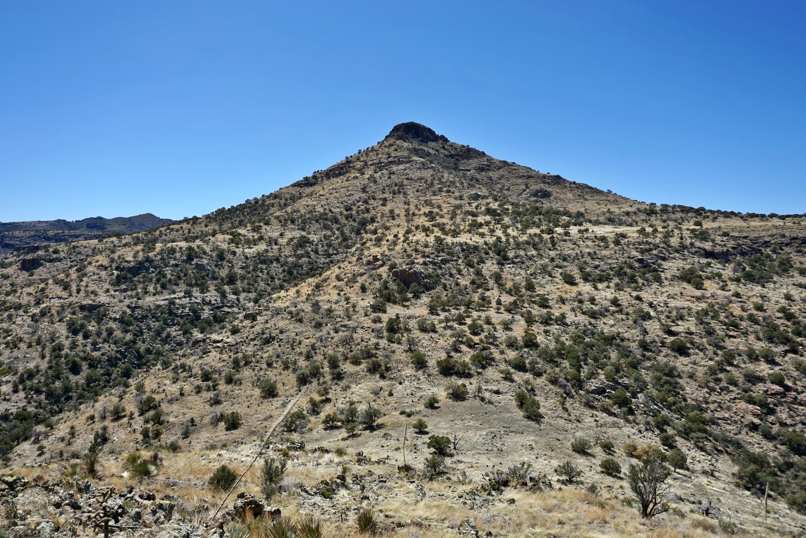
Conical China Peak thrusts from semi-desert grasslands to an all-stone volcanic summit held up by a three-pronged mesa.

Route: This description rotates clockwise on the black-line route. Bear roughly west on the Tortilla and Sycamore trails. Begin the overland segment 4.5 miles from the start and hike north to the summit. Return as you came or descend on the east ridge. We have friends who approached on the east ridge and returned on the blue-line route through Oak Creek canyon, avoiding trails entirely.

The Tortilla Trail begins on FSR 253B, a two-track that serves the administrative site at Deer Creek Cabin. A classic wooden sign, "Entering Coronado National Forest, Safford District," is planted at the trailhead, elevation 4,991 feet. Open and close the gate behind you.

The road points southwest toward Kennedy Peak. The official trailhead for Kennedy has been moved half a mile further south on FSR 253 but you could approach the massif from the Tortilla Trail as well. The range is composed of Galiuro Volcanics. In this region the rock has a reddish hue. The cliffs on the right are fractured vertically into blocks.
(Thomas Holt Ward, photo)

It was a cold, wet winter in 2023. Our water bottles froze overnight, water puddled in the ruts of the two-track, and Deer Creek was flowing at the 0.5 mile crossing. The road carries on up the creek as far as the Deer Creek Cabin at 0.8 mile. The stout little building has a stove pipe atop the old tin roof. On site is a functional vault toilet, fire pit, white metal corral, hay trough, and large brown water tank. It's a beautiful setting with a good vibe under large oak trees.
(THW, photo)

Continue straight through a green gate following the sign for Kennedy Peak 5.3 miles, and Powers Garden. The trail thins to a single track. (THW, photo)

The path begins to ascend gently. Trail engineers preferred distance over pitch, creating broad arcs to moderate the grade. The track turns sharply northeast in front of a fenceline at 1.1 miles. It swings back southwest below the stone anvil on Point 5,458'.

At 1.3 miles open and close the barbed wire gate. Several Spanish windlasses were used to tighten the wires securing the fence. (THW, photo)

The alternate route to Kennedy Peak goes south from here. When we climbed Kennedy in 2022, even the official route was difficult to follow. I wrote,"Unmaintained trails of yesteryear were returning to their natural state." Do your research before launching into that epic hike.

For China, stay on the Tortilla Trail toward Mud Spring for 1.25 miles where the route transitions to the Sycamore Trail. (THW, photo)


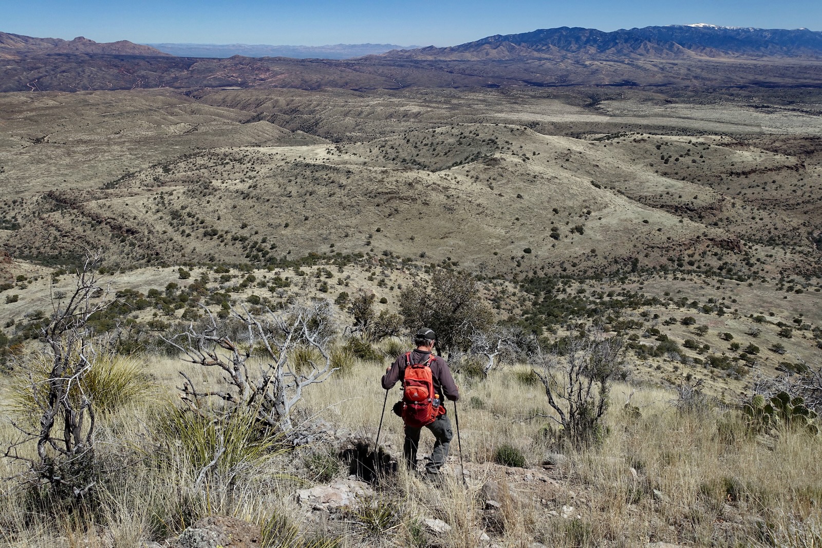
The trail passes over sheets of red rock. Medium-sized stones float on a sloping slab. Views are expansive and China Peak is visible for the duration. (THW, photo)

Give up some elevation descending into the first of several tributaries of Oak Creek at 1.6 miles. This is a significant drainage system that must be contended with at the end of the east ridge bushwhack. Cross two stone-filled branches of Oak in quick succession at 1.8 miles, 5,220 feet. They join to form the main channel just below the trail. The topo shows a trail diverting directly south but we saw no sign of it. Go through an open gate. Tall cairns guide out of the creek to the northwest. Enter the Galiuro Wilderness at 2.0 miles. The route remains in the wilderness to the summit.

The pathway is braided and elusive in places from here to our diversion point. At 5,360 feet it swings southwest to Mud Spring at 2.4 miles. Yes, it was flowing but judging from the dense bovine prints in the mud it is effectively a cattle trough unfit for human consumption.

Turn northwest on the Sycamore Trail at the spring. While there is a sign for the Tortilla Trail going south, it is not apparent on the ground. (THW, photo)

Herds of cattle have decimated the historic trail. They've left six-inch depressions in the mud and created secondary tracks that fooled us time and again. Cross another Oak tributary at 2.8 miles. Coming up out of the creek follow cairns leading uphill. The cattle had stayed on the flat creating a dominant track which we mistakenly followed. If you get more than 20 feet below the Sycamore Trail indicated on the topo map, you are wandering off with the cows.
You must travel uphill to head another branch of Oak at 3.4 miles. The crossing is preceded by a serious canyon wall. Water stains and pale-green lichen enhance the weathered escarpment. (THW, photo)

The trail bears northwest to skirt Point 6,334'. The footpath did a vanishing act in the grass and we wandered too far north. Without some serious maintenance, this trail will soon disappear altogether.

Leave the trail on a north-facing ridge just before it plunges into Sycamore Creek, 4.5 miles, elevation 6,180 feet. Walk north toward Point 6,156'. We stumbled on a use trail right on the center of the ridge. It drifts off to the east to bypass the palisade at the north end of the point.

We tried unsuccessfully to climb down through the snaggletooth.

The use trail switchbacks down on a dirt path to a fenceline at a boulder with two coils of barbed wire. The image below shows the coils, the roller on the east side of Point 6,286', and the southwest ridge of China Peak.

Walk along the fenceline back to the ridgetop at the 6,020-foot saddle north of Point 6,156'. Take the roller straight on. There are boulders to scoot around but no obstacles. It felt good to get off-trail and back into nature in the raw. This image looks back on the formidable standing rocks armoring Point 6,156'.


Gain the mesa southwest of China Peak at elevation 6,220 feet. The topography is essentially flat for a good distance. The span to the saddle at 6,140 feet, 5.5 miles, is simply delightful through golden grasses and an oak-juniper woodland.

The final heft to the summit is a consistent grade, never steep. Grass gives way to stone. Stairstep up the ridgeline. This is the playful part of the hike.

The summit block is primarily stone. After miles and miles on the trail, we were treated to a nice summit finish.

Arrive on the comfortable linear summit at 6.0 miles. It is enhanced by good sitting rocks amongst old agave and impressive cane cholla. The peak register dating to 2007 (Southern Arizona Hiking Club) was buried way down deep in the summit cairn. Mesas splay out and mountain ranges surround. Mount Graham, 10,709', in the Pinaleño Mountains is ranked first in Arizona for prominence, 6,313 feet. (THW, photo)

If Kennedy Peak is on your hiking radar, you might want to climb it while you are in the remote Galiuros. The Earthline post will give you some idea about what you are up against in terms of navigation and brush.

Westward, the Santa Catalina Mountains just make it over the Galiuro summits west of Rattlesnake Creek.
(THW, photo)

East of Aravaipa Canyon are the chaotic granitic masses in the Santa Teresa Mountains.

East Ridge
If you are at all tapped by the journey thus far, or if you are primarily a trail hiker, retrace your steps to the trailhead. The east ridge is a shortcut on paper only. It generated a new motto for bushwhacking: half the distance, double the effort, same amount of time. It looked like we were cliffed out at the very start so we down-climbed on the south side. It was very steep with loose rock for about 100 feet. We wrapped back around to the broad northeast ridgeline.

This image shoots back up at the east face of the summit block. I later asked the friend who turned us on to the east ridge how they negotiated the cliffs. He replied, "We approached the summit block head on, figuring if we couldn't break through that way, we could retreat and circle around. Turned out we got through with only minor scrambling."

Drop almost 1,000 feet in the first half mile. Footing is good enough on a rubbly surface.
For those of you who tackle the east ridge bushwhack you might find a little surprise in the saddle at 5,620 feet, 6.7 miles.

The west slope of Point 5,815' is fun Class 2+ with a great look back on China Peak. (THW, photo)
With a 3.5 hour drive home awaiting we regretfully flanked Point 5,765' (image-left) on the south. With a stone under nearly every footfall, continuous attention and patience was required.

The red bedrock in Oak Creek tempted. Our friends who returned in Oak Creek canyon (blue-line route on the map above), were in awe with the pools of water in the watercourse.

A big flat necks down to a stone peninsula. At 5,360 feet we were cliffed out. We backed up 50 feet and down-climbed through a south-side weakness.


We topped Point 5,213' and then plummeted into the Oak Creek gorge. It would have been better to track north to a shallower drop. Satellite images of the area show an old road about a third of a mile north of our drop going down to the creek and a trail pulling up the other side. Research this before you head out.

We carefully picked our way down an ultra steep slope. I recommend Earthline readers avoid the radical pitch.

Oak Creek was flowing strong over a gorgeous, boulder-strewn bed at 9.1 miles, 4,700 feet. (THW, photo)

We walked downstream a few paces to find a plausible exit.

Our pitch up the slope worked fine.

This image looks back on our descent route into the canyon, right of image-center. (THW, photo)

At 4,870 feet, we happened upon a trail that we believe is an extension of the aforementioned two-track. We went through a fenceline gate at the Coronado National Forest--Arizona State Trust Land boundary. From there we took a dirt road south back to the start, passing twin black water tanks. The only evidence of predators on this hike was a very large cougar print as we closed the loop.
