Sunday, December 4, 2016

Pontatoc Ridge to Point 7,123', Mt. Kimball Loop

Essence: Gain Pontatoc Ridge at Saddle 5,140' and proceed to its terminus at Point 7,123' ("Little Kimball"). Create a loop by returning on the Finger Rock Trail, pivoting at Kimball Saddle or Mt. Kimball. This hike features exceptional Point 5,783', the "Towers of Hercules," unique views of Window Rock while ascending a sequence of rollers, and Kimball's twin, Point 7,123'. Off-trail walking is accommodating in middle-altitude grasses rising to piñon-juniper, and finally, large-girth ponderosa. This hike completes Pontatoc Ridge; it is intended as a companion piece to lower Pontatoc Ridge. This description and hike will appeal particularly to Pusch Ridge regulars.
Travel: From Tucson's Skyline Drive, go north one mile on Alvernon Way to the Richard McKee Finger Rock Trailhead. Park in a large lot on the left. There is a drinking faucet but no other facilities.
Distance and Elevation Gain: 11.5 miles; 4,850 feet of climbing
Time: 7:30 to 9:00
Difficulty: Trail, off-trail; navigation challenging; Class 2+, no exposure
Maps: Tucson North; Sabino Canyon, AZ 7.5 Quads, or Pusch Ridge Wilderness, Coronado National Forest, USDA Forest Service, 1:24,000
Latest Date Hiked: December 4, 2016
Pusch Ridge Wilderness Bighorn Sheep Closure: It is prohibited to travel more than 400 feet off designated Forest Service trails from January 1 through April 30, bighorn sheep lambing season. Pontatoc Ridge is off-limits during that time period.
Quote: I may not know who I am but I know where I am from. Wallace Stegner

Free-standing Towers of Hercules armor Pontatoc Ridge as it approaches Point 7,123', image-right.

Route: From the Finger Rock Trailhead, elevation 3,060 feet, segue onto the Pontatoc Canyon Trail and walk to trail's end. Gain Pontatoc Ridge at Saddle 5,140'. Climb Point 5,783' and proceed through the Towers of Hercules to Little Kimball, Point 7,123'. Descend to the Kimball Saddle. Take the optional spur to Mt. Kimball before returning on the Finger Rock Trail. 2022 Note: In consideration of general usage and Lists of John, on the map below Pontatoc Peak should read Little Kimball and Linda Vista Peak should read Gorp Peak.

The first 3.2 miles of this journey on the Pontatoc Canyon Trail to Saddle 5,140' is described in detail in Pontatoc Loop Route: Canyon and Ridge Trail Connector. If you are not familiar with this trail, please consult the link.

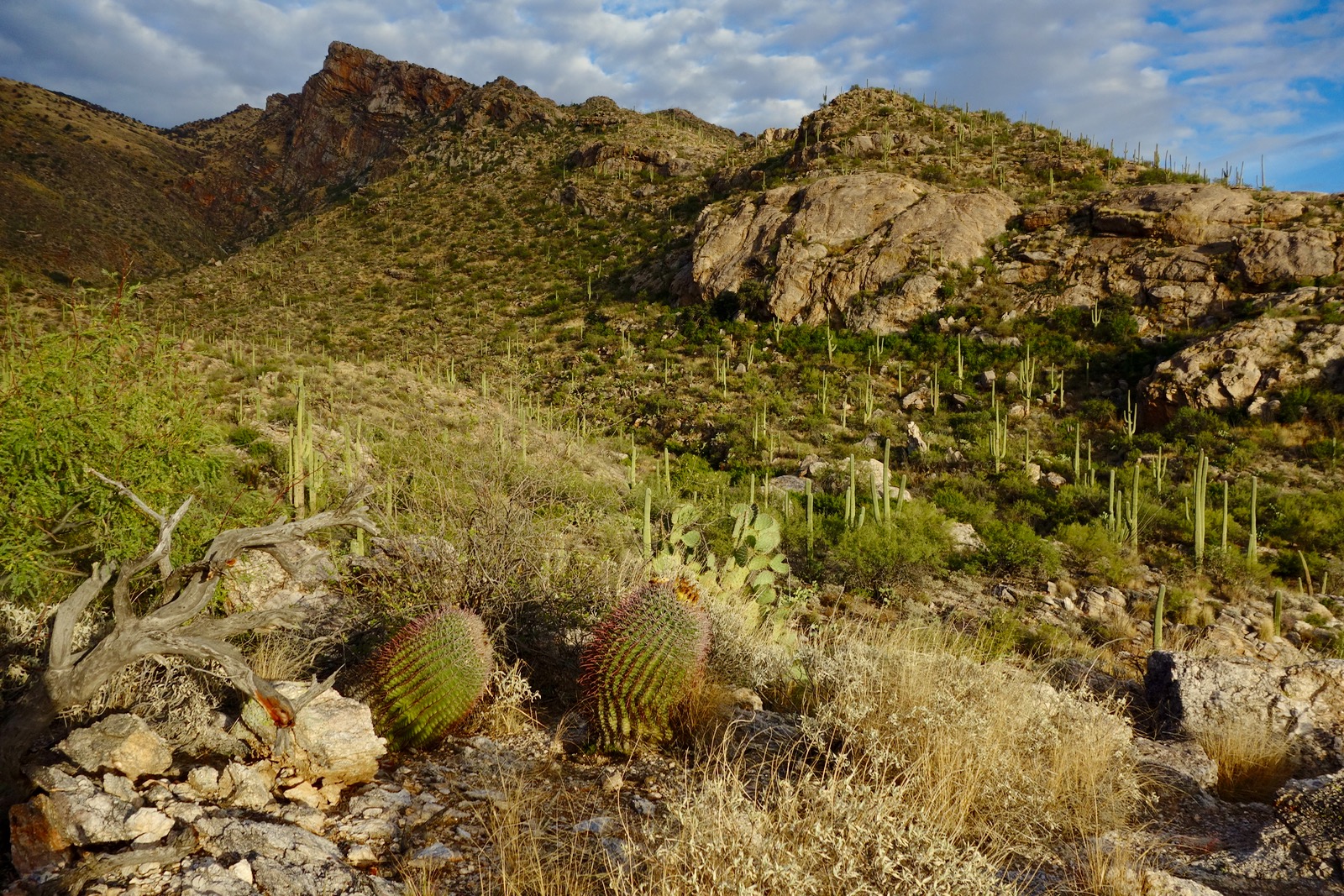
There are two essential intersections. In 0.1 mile, Finger Rock Trail #42 branches left. Proceed straight on Pontatoc Trail #410. At 0.9 mile, Pontatoc Ridge Trail #411 hangs a hard right. Stay on Pontatoc (Canyon) Trail to the End Of Pontatoc Trail sign at 3.1 miles, elevation 4,960 feet. Be advised that the last mile of trail has degenerated into a route, depicted accurately on the map above. To gain Pontatoc Ridge from here, cross the wash and head northeast for 0.1 mile. The image below looks back on Saddle 5,140' and Point 5,391', the gendarme marking the upper bounds of lower Pontatoc Ridge.

From the saddle, Point 5,783' is 0.3 mile away and 600 feet up. This is the steepest gradient of the entire hike. Walking is pleasant on the boulder strewn grassy slope. It is pretty easy to dodge sotol, beargrass, shindaggers, beefy green agave, and Arizona oak. Bear northeast, holding to the rounded ridge.

Point 5,783' has a small rocky crest with sitting stones. There is something so homey and comfortable about this little prominence that it would be a nice destination. A tiny notebook sits in a glass jar with a rusty lid. The continuous register spans 46 years. The first entry reads, "This register placed here Feb. 21, 1970 by the SAHC." The outcrop doesn't see a lot of visitors; the most recent name was four years ago. Judging from the commentary, a favorite loop back in the day was Pontatoc Canyon trail onto an interior Pontatoc ridge to Point 6,820', and looping to this very place. The old timers informally called Point 6,820', Gorp Peak. Inside the jar is a metal film canister with a single entry shown below. From the Southern Arizona Hiking Club Bulletin, Vol. 50, #11:

A hiker named Harry Von B.
Would roam through the desert with glee.
He'd glide through the cactus
With the ease of long practice
But "why?" is what no one could see.


Pontatoc Ridge is clearly displayed from Point 5,783'. Point 7,123' is image-center. (THW, photo)

Drop to 5,660 feet and then center line a series of rollers. The ascent to the next knoll is gentle on a grassy hill with alligator juniper and chunky nuggets of milky white quartz embedded with crystals. Mexican piñon begin at 6,000 feet. From the promontory at 6,200 feet, 4.2 miles, look across Ventana Canyon and directly through Window Rock.  Window Peak is image-center.

The divide between Pontatoc and Ventana Canyons narrows. Work around the vegetation, mostly piñon-juniper with big patches of resurrection moss. Pictured below is the 6,500 foot hillock.

The southwest ridge of Gorp Peak is clearly visible from 6,500 feet.

On the east side of the ridge, pillars rise overhead and march up the side of the precipice from below. The first series of towers begins with playful Class 2+ scrambling.

At 4.9 miles, 6,800 feet, intersect the ridge to Gorp Peak. The prominence is only 0.3 mile distant. We decide to defer so we can reprise the hike described in the peak register on Point 5,783'. Judging from this image shot from Point 5,730' on Linda Vista Ridge, the peak can also be climbed from Linda Vista Saddle.

Enter the Towers of Hercules, granitic monoliths. In 2013, we stayed on the rock as much as possible, climbing everything we could. This was great fun but time-consuming. Inevitably you will get towered-out. Bypassing to the east is not an option so this time we skirted the towers on the west, staying right at the base of the rock. It is a pretty quick passage plowing through vegetation.

Pass by the Guardian of Pontatoc, a venerable alligator juniper. (THW, photo)

Summit Point 7,123', Little Kimball, at 5.3 miles. It stands just shy of 300 feet above Kimball Saddle and thus, is not a legal summit. Locate the peak register in a ten-foot circular clearing. Living in obscurity under the shadow of Mt. Kimball, the last visitor to this admittedly unremarkable crest was three years prior. The view is compromised by tree cover but you can see Mt. Kimball, so similar in vegetation and elevation. Cumulative elevation gain to this point is a hefty 4,400 feet.  

Descend easily 0.4 mile on the broad northwest ridge to Kimball Saddle, elevation 6,860 feet. This is the all-important signed junction for the Finger Rock Trail and Pima Canyon Trail #62. If you've had enough, simply return to the trailhead by going left on the Finger Rock Trail.

Note: In 2013, we returned via Ventana Canyon because we had not been on the two mile connector between Finger Rock and Ventana Canyons. Turn right on the Finger Rock Trail and in one hour you will intersect the Ventana Trail down in the canyon. This secondary trail is well marked with cairns. It is a convoluted landscape and you will go over, around, and under towering cliffs. This option is truly exciting but it does require a shuttle between the Ventana and Finger Rock Trailheads.

To visit Mt. Kimball (so close!), turn right onto the Pima Canyon Trail. The peak is just half a mile away with 400 additional feel of elevation gain. Walk through a stately ponderosa forest. Watch for the signed 0.1 mile spur to Mt. Kimball. Pass a small view opening at 7,240 feet, a false summit. Keep going! The path descends slightly and then rises gently to the true summit, elevation 7,258 feet, 6.2 miles.

While Kimball is the most wooded of all the Pusch Ridge peaks, its crest is pure, bare rock protruding like the prow of a ship. The lookout is precipitous. The broad swing view is jolting, framing peaks the full length of Pusch Ridge. More towers (they're everywhere!) soar above treetops below the standing perch.

Mt. Kimball affords the best view of Little Kimball. For those who climb Mt. Kimball by way of Pontatoc Ridge, there is a strong sense of completion.

Mt. Kimball is the first peak I climbed years ago in the Santa Catalina Mountains. It is pure magic, a euphoria generator. (THW, photo)

Return to Kimball Saddle and turn right on the Finger Rock Trail. I have described this trail in a previous post: Mount Kimball, 7,258': Pima Canyon to Finger Rock Canyon. If you are unfamiliar with this beautiful pathway, please consult the link. You can trim the mileage by 0.2 and elevation gain by 50 feet if you do not visit Linda Vista Saddle on your way home. The lighting is superb every evening on the Finger Rock Trail. This is the golden hour when delicate grasses are backlit and the massive ridge ablaze.

Thursday, December 1, 2016

Linda Vista Ridge to Point 5,730': The Divide Between Finger Rock and Pontatoc Canyons

Essence: Climb along the divide between Finger Rock Canyon and the two canyons of Pontatoc. The steep, off-trail ridge features continuous views, three gendarmes with unusual bypasses, and one final obstacle with a narrow access corridor. Ascend the golden ramp seen from Tucson to spectacular Point 5,730' before down-climbing to Linda Vista Saddle. Chose to return on the Finger Rock Trail or off-trail on an interior Pontatoc Canyon ridge.  
Travel: From Tucson's Skyline Drive, go north one mile on Alvernon Way to the Richard McKee Finger Rock Trailhead. Park in a large lot on the left. There is a drinking faucet but no other facilities.
Distance and Elevation Gain: 6.4 miles: 3.1 miles to Linda Vista Saddle, plus 3.3 miles down Finger Rock or Pontatoc Canyon trails; 3,000 feet of climbing
Time: 4:00 to 6:00
Difficulty: Trail, off-trail; navigation challenging; Class 2+; no exposure unless you go looking for it; carry all the water you will need.
Map: Tucson North, Arizona 7.5 Quad, or Pusch Ridge Wilderness, Coronado National Forest, USDA Forest Service, 1:24,000
Date Hiked: December 1, 2016
Pusch Ridge Wilderness Bighorn Sheep Closure: It is prohibited to travel more than 400 feet off designated Forest Service trails from January 1 through April 30, bighorn sheep lambing season. Linda Vista Ridge is off-limits during that time period.
Quote: Every ridge has its day. Thomas Holt Ward

Morning light illumines Linda Vista Ridge and Point 5,730' as seen from the first roller at 3,580 feet. From the left, this image captures The Tombstone, Prominent Point, Finger Rock and its Guard, Mt. Kimball, Point 5,730', "Gorp Peak," our interior return ridge, and Pontatoc Ridge. (THW, photo)

Route: Divert from the Finger Rock Trail onto an abandoned path to gain Linda Vista Ridge at 3,580 feet. Ascend the ridge to Point 5,730'. Downclimb to Linda Vista Saddle. From here, most hikers will want to descend on the Finger Rock Trail, the red-line route. Alternatively, return off-trail on a ridge straddling the two canyons of Pontatoc. Use the blue-line route to connect with the Pontatoc Canyon Trail.

Exhilaration begins with the first steps from the Finger Rock Trailhead, elevation 3,060 feet. Walk through a Sonoran garden on a natural bedrock incline. At the signed junction in 0.1 mile, Finger Rock Trail #42 branches left. Proceed straight on Pontatoc Trail #410. This image shows the first roller and Point 5,730' from the junction.

Drop 30 feet into a shallow depression before climbing gently. Eight to ten minutes into the hike, at 0.4 mile, on top of a rise at 3,180 feet, come to a wide spot in trail, shown below. Look carefully for a faint path veering north; there are no other markers. This neglected and unmaintained trail is disappearing but there are rock boundary remnants and occasional cairns. Follow intuitively the path of least resistance wandering between Sonoran plants, aiming for the top of the first knoll. Thus, we were able to stay on or close to the old track the whole way.

Crest the roller at 0.8 mile, 3,580 feet. This humble hilltop affords stellar views of the region and would be a pleasant goal in itself. The route is off-trail from here. Unable to locate any information on this ridge, we had the intense pleasure of walking into the mystery. We didn't know if the route would be blocked by impassable gendarmes or the final obstacle. Shindagger and boulder dodging slow the pace but are not a serious impediment. Mesquite, palo verde, saguaro, teddybear cholla, and ocotillo give way to sotol, bear grass, and Arizona oak.  Friction climb a slab with good texture.

Gain a rocky knob at 4,120 feet, 1.4 miles, with a good view of the highpoint. Scramble down the left side of the nose. A series of risers direct to three gendarmes, shown, each separated by a tenth of a mile. (THW, photo)

At 1.7 miles, 4,200 feet, confront the first gendarme. Scoot around on the right at the base of the wall. The northface is a 30 foot vertical cliff. A shredding shrub prohibits going over the top of the second gendarme at 4,360 feet. Bypass on the Pontatoc side. The third rampart at 4,500 feet is the trickiest. Bypass right/east once more, staying snug against the wall where exposure is mild. Pass an overhang at ground level. There is a Class 2+ scramble and a 75 foot climb back to the ridgetop.

This image looks back on the third obstacle.

At 4,700 feet, get a revealing look at the final obstruction which is startling in its beauty. The broad, blocky escarpment possesses, thankfully, a center access chute. Massive cliffs bar a work-around. (THW, photo)

The approach is over at 4,880 feet. Rock stacks frame the narrow corridor. Class 2+ climbing is steep and loose in places but not exposed.

After 200 feet the constriction broadens but remains pitched. Ascend the grassy, golden ramp seen from afar. Reach the highpoint of Linda Vista Ridge, Point 5,730', at 2.7 miles after 2,770 feet of vertical. The divide doubles as the southeast wall of Finger Rock Canyon. It renders a unique perspective on Prominent Point and Finger Rock Guard. (THW, photo)

In the north are Mt. Kimball and Gorp Peak, elevation 6,820 feet. To the wide-open south is the whole sweep of everything out in front of Pusch Ridge fading into the null distance.

Anticipating the final ridge escarpment between Point 5,730' and Linda Vista Saddle, we didn't know whether we'd find a suitable bypass or be forced to retrace our steps. From the highpoint, step down the first two knobs, Class 2+. Climb the final challenge easily. At 5,700 feet, it is a super sweet completion promontory. (THW, photo)

A 100 foot east face cliff requires a short retreat, almost to the first saddle. Staying as high as possible on sneak routes, bypass on the northwest side, returning to the ridge briefly before reaching Linda Vista Saddle. This image, taken from the Finger Rock Trail, indicates the final work-around.

Linda Vista Saddle, at 3.1 miles and 5,580 feet is the conclusion of the lower ridge, though it carries on to Gorp Peak and Little Kimball. From here, there are two choices for the return. Most hikers will want to descend on the Finger Rock Trail, the red-line route above, back to the start. It is 0.4 mile to Linda Vista overlook and 2.8 miles from there to the trailhead.

For those who wish to explore the ridge dividing the two Pontatoc drainages, stay on the black-line route. The transition to the southwest-running ridge is straight-forward. From Linda Vista Saddle, take the minor ridge southeast down a grassy hillside free of shindaggers, shown.

Drop left into the near canyon, crossing it at about 5,280 feet, above a significant pouroff.  The bedrock is Catalina Gneiss, a prize-winning Pusch Ridge formation. (THW, photo)

Contour to the ridge, hitting it at about 5,300 feet. We penetrated a tower cluster straight on but got pushed out of the maze. Bypass on the left/southeast and regain the ridge, Class 2+.

The exquisite, classic Sonoran ridge features rock islands in a sea of grass. There are wild views of Linda Vista Ridge and its imposing wall.

The ridge splits at 5,000 feet. Veer left on the blue-line route. It intersects the Pontatoc Canyon Trail at about 4,400 feet. The trail is obscure on the grassy hillside. Watch for orange flagging and occasional cairns marking the underutilized track. Presumably, if you are doing this hike, you are already familiar with this trail and are aware that it has degenerated into a route. Once you've secured the trail, stay on it to the trailhead.

We kept going to explore the principal ridge but I do not recommend it. There is nothing spectacular on the ridge that you would not want to miss. Shindaggers (mosquitoes of the plant world) are hideous, practically taking over the entire domain. We did find a place of peace at 4,740 feet which we named Resurrection Camp after the lovely thick moss, protective rocks, and gracefully spaced ocotillo and sotol.

Below the camp, the threat of getting speared was present with every step. However, we were determined to remain on the ridge until we reached the insurmountable fins shown below at 3,830 feet. From there, we bailed to the canyon floor (while parrying with blades) and climbed 100 feet up the opposite bank to the Pontatoc Canyon Trail. Close the loop 0.4 mile in advance of the trailhead.

Monday, November 28, 2016

Pontatoc Loop Route: Canyon and Ridge Trail Connector

Essence: Begin on the Pontatoc Canyon Trail and link to Pontatoc Ridge. Delightful and exciting exploration of lower Pontatoc Ridge. From Saddle 5,140' there is a Class 3 scramble to bypass Point 5,391'. Then, stay on the rocky spine the whole way down; that is the appeal. The high ridge has commanding views and diverse terrain, even an unexpected and playful knife.
Travel: From Tucson's Skyline Drive, go north one mile on Alvernon Way to the Richard McKee Finger Rock Trailhead. Park in a large lot on the left. There is a drinking faucet but no other facilities. No dogs.
Distance and Elevation Gain: 7.0 miles; 3,250 feet of climbing
Time: 5:00 to 7:00
Difficulty: Trail, off-trail; navigation challenging; for experienced Class 3 scramblers; mild exposure
Map: Tucson North, AZ 7.5 Quad, or Pusch Ridge Wilderness, Coronado National Forest, USDA Forest Service, 1:24,000
Latest Date Hiked: November 28, 2016
Pusch Ridge Wilderness Bighorn Sheep Closure: It is prohibited to travel more than 400 feet off designated Forest Service trails from January 1 through April 30, bighorn sheep lambing season. The off-trail portion of Pontatoc Ridge is off-limits during that time period.
Quote: In certain landscapes, the planet reveals its skeleton. I come here for this reason, walking the bones of the earth. There are no ambiguities other than what I bring with me, and even those begin to wear away in this place.
Craig Childs

Lower Pontatoc Ridge begins with the rawboned gendarme, Point 5,391', and descends to familiar Pontatoc Point 5,080' before sliding to a halt in Sonoran lowlands. (THW, photo)

Route: Hike the Pontatoc Canyon Trail to its end. Climb to Saddle 5,140' and explore Point 5,391'. Backtrack to trail's end to bypass the gendarme and scale the ridge. Climb Pontatoc Point 5,080' from the unconventional northeast side. Then, stay on the ridge to elevation 3,200 feet. Divert back to the Pontatoc Trail. Caution: Do this hike as described in the clockwise direction to prevent a dangerous and ambiguous downclimb at Point 5,391'. 

From the Finger Rock Trailhead at 3,060 feet, immersion in the Sonoran landscape is immediate. The slope of the Pusch Ridge incline syncs perfectly with the human traveler. I feel a sense of gladness and incredulity while walking on a thread of bedrock. At the signed junction in 0.1 mile, Finger Rock Trail #42 branches left. Proceed straight on Pontatoc Trail #410.

At 0.5 mile, note a gorilla trail branching toward the base of Pontatoc Ridge. If you get lucky, you'll peg this on the return. The trail goes over two small ridges before crossing Pontatoc Canyon at 0.7 mile. Occasionally, there is water in the wash but don't count on it. Reach a signed junction at 0.9 mile. Pontatoc Ridge Trail #411 goes off on a hard right. Stay on Pontatoc Trail #410, commonly called the Pontatoc Canyon Trail. For information on the ridge trail and caves, see the end of this post.

The Pontatoc Canyon Trail initiates on the southeast side of the drainage, rising with the canyon. Locate the Old Spanish Mine caves in this image near the top of the imposing cliff.

At 1.4 miles, 3,600 feet, the trail crosses to the northwest side of the wash. It soon moves away from the drainage and makes short switchbacks up the east-facing slope. The primitive trail is thin with grass in the track. Watch for it. The angle is typical Pusch Ridge steepness. My attention is diverted by the distinctive horizontal striations adorning the Pontatoc escarpment.

Cross a grassy hillside on the contour before switchbacking down into the Amphitheater at 2.2 miles. A side draw comes in from the north to merge with Pontatoc Canyon before they plunge united into a trench. The track crosses the convergence on Catalina Gneiss and goes up the east side for a tenth of a mile before crossing back to the west. The Amphitheater is quite beautiful, a turn-around for many judging from the neglected trail beyond this point.

Back on the northwest side, shindaggers encroach on the path as it climbs the slope directly across from Pontatoc Point. From this vantage, get a sneak preview of the bypass around Point 5,391', shown. Locate the skyhole in the gap. Our route aims for the window before scrambling on its right to the spine.

The final segment of the Pontatoc Canyon Trail has degenerated into a route. In 2013, the trail was discernible but now even the platform has been absorbed back into the earth. The trail has languished because it doesn't go to a destination proper. Bear northeast on the grassy, rounded ridge, watching for faded orange flagging and occasional cairns marking the underutilized track. The ribbons are tied to ocotillo and the masts of spent agave. Be vigilant. The GPS track is good on the map above. All assistance ceases in the final 0.2 mile. Walk south, right down the minor ridge and you will come to the End Of Pontatoc Trail sign at 3.1 miles, elevation 4,960 feet. This location is at the base of a small ridge, just below where two drainages converge. Note that the rest of this loop is off-limits during bighorn lambing season.

For those who do not wish to go to the saddle or mess around on the gendarme, our route returns shortly to this location. To reach Saddle 5,140', cross the drainage and locate a game/social trail that directs toward the saddle. It's not a big deal if you can't find it; the saddle is just a tenth of a mile past the sign. This premier location is the launch point for upper Pontatoc Ridge to Pontatoc Peak (Point 7,123') and Mount Kimball.

It is conceivable that technical climbers or superb scramblers can scale Point 5,391'. We were repelled by the exposure and general difficulty. We scouted the nose seen in the image below before scooting around the southeast side. We turned around after being tempted by an exposed, steep ramp. If you do summit this well-armored gendarme, downclimbing into the southwest gap looks improbable. (THW, photo)

For the bypass, return to Saddle 5,140' and back down to the End Of Pontatoc Trail sign. Subtract 0.7 mile from this hike if you don't go to the saddle and poke around on the gendarme. The next goal is to get back on the ridge at first opportunity. The image below, taken on another hike, illustrates the challenge. After careful scrutiny, I expect that our route is the only passage to the ridgecrest. Directions follow.

From the sign, walk down the southeast side of the canyon. Once under the gendarme, barge up the steep slope to the base of the big obstacle.

In the defile west of the wall, squeeze past trees up the steep crack angling right. Then move left at the base of the caprock.

Locate the arch-like opening in the gap between the gendarme and main ridge. Climb into the hole if you wish and see that you are on a serrated knife comprised of towers: the route is just below. Go slightly right and do a Class 3 scramble. In this image, my friend is topping out.

Gain the spine at 4.1 miles, 5,340 feet. Stand on big blocks of rock while looking back on the climber's crack, seen below. The gap between the gendarme and the ridge is implied in this image. It would be quite difficult and ill advised to attempt to find the one-and-only access crack going in the opposite direction. (THW, photo)

Going down-ridge, big boulders and manzanita quickly give way to unimpeded walking with stellar views. (THW, photo)

Go over a small roller and down to the Pontatoc Point saddle at 4,840 feet. Looking at the image below, there is nothing tricky about summiting the point, Class 2. Mount the steep slope, a grass mix, staying left/southeast of the bedrock nose. Pass distinctive white stones with natural orange and red paint.

Arrive at familiar Pontatoc Point, 5,080 feet, at 4.6 miles. For those who have stood here many times, it is deeply satisfying to have reached the crest from the northeast. This image looks back on the approach ridge.

On a perfectly clear 150 mile day, swing around to take in: the Santa Catalina Mountains, the Rincons, Whetstones, Santa Ritas, Baboquivari Peak, the Tuscon Mountains, on and on it goes. In the background of this image locate The Tombstone,  Prominent Point, and Finger Rock Guard. Closer, is Linda Vista Ridge and Point 5,730'.

Employ the social trail initially upon leaving Pontatoc Point since it holds to the ridge. Leave it and climb the first prominence shown, an easy Class 2 scramble. If at any point you've had enough off-trail travel, the use trail crosses the ridge in numerous places and bailout options are abundant.

Have fun on the razor sharp knife. There is mild exposure here but the ledges at foot level are generous.

The image below shows the knife run-out and the next prominence. The trail crosses in the saddle between them at 5.3 miles, 4,120 feet. If you are not a ridge purist, I recommend getting on the trail here. Past this point, be patient with the backbone. Boulders are nonsensically jumbled up, shindaggers and prickly pear are abundant.

This image looks back on the ridge, taken from the knob seen in the image above at 4,180 feet. (THW, photo)

Below the knob, the divide splits. Move right/southwest to get on the proper ridge, pleasant and broad-topped. Walk through a teddybear cholla forest. Watch out in the nursery! (THW, photo)

The ridge trail at 3,500 feet is handy and on point so make use of it to 3,360 feet where the trail switchbacks way to north. Leaving it once again, walk on globs of rock. Just above a private home, cut down to the canyon on big, open slabby stone. Cross the wash and ascend 100 feet to intersect the Pontatoc Trail within half a mile of the trailhead.

Pontatoc Ridge Trail and Caves
The Pontatoc Ridge Trail is well documented on the web. At the signed junction at 0.9 mile, hang a hard right on trail #411. This was once called the Old Spanish Mine Trail. The path follows the 3,400 foot contour 0.3 mile to the southwest ridge of Pontatoc Point. The track commences a glorious hike up the spine with exquisite views of Pusch Ridge and the deep yonder.

Reach the End Of Trail sign at 2.4 miles, 4,300 feet. Beyond is the protected area for bighorn and date restrictions apply. To reach Pontatoc Point, make a lateral traverse on a fine social trail to the ridge and ascend to 5,080 feet. 

The Old Spanish Mines are dug into a shelf on the precipitous cliff. To reach them, at the End Of Trail sign, continue on a wildcat trail that clings to the northwest face of the escarpment. The path is steep, loose, and exposed. It is a Class 3 scramble into the mines.

Carry a strong, trustworthy light. No one is sure what the miners were extracting. About one hundred yards in, the cave becomes all crystals, all around, even on the floor to a degree. They are not anything that would drive a rockhound crazy, but they are unusual and kind of eerie in the light of a headlamp.

Entrance into the only mine with non-technical access. (THW, photo)

Looking out from the mine portal. (THW, photo)